Perry County, Pennsylvania

Last updated

Perry County
Saville PA C Bridge 2.JPG
Perry County, Pennsylvania.gif
Map of Pennsylvania highlighting Perry County.svg
Location within the U.S. state of Pennsylvania
Pennsylvania in United States.svg
Pennsylvania's location within the U.S.
Coordinates: 40°24′N77°16′W / 40.4°N 77.27°W / 40.4; -77.27
CountryFlag of the United States.svg United States
StateFlag of Pennsylvania.svg  Pennsylvania
Founded22 March 1820
Named for Oliver Hazard Perry
Seat New Bloomfield
Largest Borough Marysville
Area
  Total556 sq mi (1,440 km2)
  Land551 sq mi (1,430 km2)
  Water4.1 sq mi (11 km2)  0.7%
Population
 (2020)
  Total45,842
  Density82/sq mi (32/km2)
Time zone UTC−5 (Eastern)
  Summer (DST) UTC−4 (EDT)
Congressional district 12th
Website www.perryco.org

Perry County is a county in the Commonwealth of Pennsylvania. As of the 2020 census, the population was 45,842. [1] The county seat is New Bloomfield. [2] The county was created on March 22, 1820, and was named for Oliver Hazard Perry, a hero of the War of 1812, who had recently died. [3] It was originally part of Cumberland County and was created in part because residents did not want to travel over the mountain to Carlisle, the county seat of Cumberland County. Landisburg became the temporary county seat before New Bloomfield was ultimately chosen.

Contents

Perry County is included in the Harrisburg–York–Lebanon combined statistical area. The county is served by the 717/223 area codes.

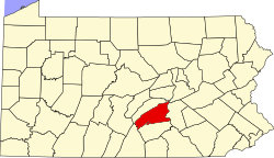
In 2010, the center of population of Pennsylvania was located in the eastern end of Perry County. [4] Green Park, an unincorporated village located in northeastern Tyrone Township, serves as Perry County's midpoint between the Conococheague Mountain in the west and the Susquehanna River to the east. [5]

Geography

The county terrain is formed by the folded Appalachian Mountain ridges which run from southwest to northeast across the county. The terrain slopes to the northeast, [6] with its highest point on the Blue Mountain Ridge, which delineates the border between Perry and Cumberland counties. The ridge peaks at 0.83 miles (1.34 km) NE from Perry County's southmost corner; it measures 2,269 ft (692 m) ASL. [7] The county is drained by the south-flowing Susquehanna River, which forms almost all of its eastern boundary. The Juniata River enters Perry County from Juniata County near Millerstown, and flows southeast to its confluence with the Susquehanna River near Duncannon. The county also contains several creeks, runs, and lakes, [8] which provide recreational and fishing [9] opportunities, formerly powered mills throughout the county [10] and provided transport venues. To this day, canoeing and kayaking are forms of recreation which utilize the Shermans Creek and other waters in the county. [11]

The county has a total area of 556 square miles (1,440 km2), of which 551 square miles (1,430 km2) is land and 4.1 square miles (11 km2) (0.7%) is water. [12]

The Appalachian Trail runs through the town of Duncannon. The county is also famous for being the northern head of the Tuscarora Trail.

Perry County has a hot-summer humid continental climate (Dfa) and average monthly temperatures in New Bloomfield range from 28.5 °F in January to 73.2 °F in July. The hardiness zone is 6b except in Marysville where it is 7a ( Archived 2021-06-18 at the Wayback Machine ). Common trees include red maple, [13] Virginia pine, oak, eastern white pine, [14] eastern hemlock, [15] birch, shagbark hickory, [16] and juniper, though American sycamore, ironwood (ex: Hop-hornbeam, American Hornbeam), sugar maple, black walnut, elm, alder, black cherry, black locust, and sassafras are also fairly common. [17] [18] [19] [20] [21] [22] Mosses of various species are common sights, especially on fallen tree logs, along streams, on tree trunks, [23] and in sidewalk cracks, usually growing in shaded areas. Ferns also grow along streams and in shaded areas, and are also commonly seen in Perry County woodlands.

Adjacent counties

Major highways

Protected areas

Demographics

Historical population
CensusPop.Note
1820 11,342
1830 14,26125.7%
1840 17,09619.9%
1850 20,08817.5%
1860 22,79313.5%
1870 25,44711.6%
1880 27,5228.2%
1890 26,276−4.5%
1900 26,2630.0%
1910 24,136−8.1%
1920 22,875−5.2%
1930 21,744−4.9%
1940 23,2136.8%
1950 24,7826.8%
1960 26,5827.3%
1970 28,6157.6%
1980 35,71824.8%
1990 41,17215.3%
2000 43,6095.9%
2010 45,9695.4%
2020 45,842−0.3%
US Decennial Census [24]
1790–1960 [25] 1900–1990 [26]
1990–2000 [27] 2010–2017 [28] 2010-2020 [29]

2000 census

As of the 2000 United States Census, there were 43,602 people, 16,695 households, and 12,320 families in the county. The population density was 79.1 people per square mile (30.5 people/km2). There were 18,941 housing units at an average density of 34.4 units per square mile (13.3/km2). The racial makeup of the county was 98.54% White, 0.43% Black or African American, 0.12% Native American, 0.15% Asian, 0.01% Pacific Islander, 0.21% from other races, and 0.54% from two or more races. 0.69% of the population were Hispanic or Latino of any race. 45.8% were of German, 16.4% American, 7.8% Irish and 5.0% English ancestry. 96.8% spoke English and 1.2% Spanish as their first language.

There were 16,695 households, out of which 33.2% had children under the age of 18 living with them, 61.6% were married couples living together, 7.8% had a female householder with no husband present, and 26.20% were non-families. 21.7% of all households were made up of individuals, and 9.30% had someone living alone who was 65 years of age or older. The average household size was 2.58 and the average family size was 3.01. There is also a high population of Anabaptist communities, such as Amish and Mennonites.

The county population contained 25.5% under the age of 18, 7.4% from 18 to 24, 29.8% from 25 to 44, 25.1% from 45 to 64, and 12.3% who were 65 years of age or older. The median age was 38 years. For every 100 females, there were 98.4 males. For every 100 females age 18 and over, there were 96.9 males.

A lake in Kennedy's Valley, Perry County PA A lake in Kennedy's Valley, Perry County PA with dormant alder trees.jpg
A lake in Kennedy's Valley, Perry County PA

2020 census

Perry County Racial Composition [30]
RaceNum.Perc.
White (NH)42,83893.4%
Black or African American (NH)2890.63%
Native American (NH)500.11%
Asian (NH)1390.3%
Pacific Islander (NH)30.01%
Other/Mixed (NH)1,6113.51%
Hispanic or Latino 9122%

Metropolitan Statistical Area

The United States Office of Management and Budget [31] has designated Perry County as the Harrisburg-Carlisle, PA Metropolitan Statistical Area (MSA). As of the 2010 census [32] the metropolitan area ranked 6th most populous in the State of Pennsylvania and the 96th most populous in the United States, with its population of 549,475. Perry County is also a part of the larger Harrisburg–York–Lebanon combined statistical area (CSA), which combines the populations of Perry County as well as Adams, Cumberland, Dauphin, Lebanon and York Counties in Pennsylvania. The Combined Statistical Area ranked 5th in the State of Pennsylvania and 43rd most populous in the United States with a population of 1,219,422.

County government

Commissioners

(as of January 2024)

Sheriff

State Senate [33]

State House of Representatives [33]

United States House of Representatives

United States Senate

Emergency services

The county's emergency services are located in the basement of the Perry County Courthouse. The 911 center's coverage area includes almost all of Perry County and portions of Juniata and Dauphin counties.

Politics

In 2016, Donald J. Trump received 73.07% of the presidential vote, compared to 21.67% to Hillary Clinton, and 5.26% for candidates Gary Johnson, write-ins, Jill Stein, and Darrell L. Castle, respectively. The county has voted for the Republican in every presidential election since 1964. In 2006, Lynn Swann received 9,998 votes (69%) to 4,477 votes (31%) for Ed Rendell, making it Swann's strongest county in his defeat. Rick Santorum also received more than 60% of the Perry County vote in his defeat. [34]

United States presidential election results for Perry County, Pennsylvania [34]
Year Republican Democratic Third party
No.%No.%No.%
2020 18,29373.98%5,95024.06%4851.96%
2016 15,61673.07%4,63221.67%1,1235.25%
2012 13,12068.28%5,68529.59%4102.13%
2008 13,05865.79%6,39632.22%3941.99%
2004 13,91971.65%5,42327.91%850.44%
2000 11,18469.56%4,45927.73%4362.71%
1996 8,15656.19%4,61131.77%1,74812.04%
1992 7,87151.35%4,08626.66%3,37021.99%
1988 8,54568.18%3,91031.20%780.62%
1984 9,36571.42%3,69228.16%560.43%
1980 8,02663.70%3,68129.22%8927.08%
1976 7,45460.50%4,60537.38%2612.12%
1972 8,08273.31%2,73124.77%2121.92%
1968 6,65561.34%2,94427.14%1,25011.52%
1964 5,36446.84%6,05452.86%340.30%
1960 8,13470.30%3,41329.50%230.20%
1956 7,51167.59%3,57632.18%250.22%
1952 6,73368.76%3,04231.07%170.17%
1948 5,44467.71%2,59632.29%00.00%
1944 5,72263.37%3,26536.16%430.48%
1940 5,87756.02%4,60143.86%120.11%
1936 5,75949.65%5,78049.83%610.53%
1932 4,40253.23%3,73345.14%1341.62%
1928 6,46977.66%1,80721.69%540.65%
1924 4,18557.52%2,71037.25%3815.24%
1920 3,78760.64%2,31437.05%1442.31%
1916 2,57551.46%2,34846.92%811.62%
1912 1,14023.48%1,94139.98%1,77436.54%
1908 3,26958.82%2,18439.29%1051.89%
1904 3,43360.72%2,09437.04%1272.25%
1900 3,40057.41%2,44041.20%821.38%
1896 3,53757.23%2,47740.08%1662.69%
1892 3,12052.20%2,70545.26%1522.54%
1888 3,16853.04%2,73845.84%671.12%

Education

Public School Districts

Intermediate unit

The Capital Area Intermediate Unit 15 is a state approved education agency that offers to Perry County school districts, charter schools, private schools, and home school students, a variety of services including: a completely developed K-12 curriculum that is mapped and aligned with the Pennsylvania Academic Standards (available online), shared services, a joint purchasing program and a wide variety of special education and special needs services.

Private schools

As reported on EdNA (ED Names and Addresses) by the Pennsylvania Department of Education:

  • Blue Goose Children's Learning Center, Inc – Newport
  • Carson Long Military Institute
  • Clarks Run Parochial School – Blain
  • Community Christian Academy – Newport
  • Farm Lane School – Ickesburg
  • Fowlers Hollow School – Blain
  • Heritage Christian School – West Perry
  • Honeysuckle Ridge School – Elliotsburg
  • Kuddly Bear Child Care Center Inc. – Duncannon
  • Loysville Youth Development Center – Loysville
  • Manassa School – Blain
  • Messiah Day Care Center – Elliottsburg
  • Mountain View Parochial School – Ickesburg
  • Perry View Parochial School – Landisburg
  • Raccoon Valley Amish School – Millerstown
  • Shermans View School – Loysville
  • Stony Point School – Loysville
  • Sunset Valley School – Millerstown

Trade schools

Public libraries

Media

Newspapers

The county is home to four weekly newspapers, three published by Advance Publications of Perry and Juniata Counties, Inc. associated with The Patriot-News of Harrisburg: Duncannon Record, The News-Sun, and Perry County Times. [36] The Perry County Weekly is published by The Sentinel in Carlisle, Cumberland County, by Lee Enterprises of Davenport, Iowa. [37]

Books

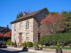
There are numerous historical books written about the county, available at the Council of the Arts in Newport as well as other establishments. They cover various topics of the county's past, including an historical overview of the Blain area; an account of the life of the early settlers along the Shermans Creek in three townships; [38] and an account of a Civil War battle on Sterrett's Gap. [39]

Communities

Map of Perry County, with Boroughs (red) and Townships (white) Map of Perry County Pennsylvania With Municipal and Township Labels.png
Map of Perry County, with Boroughs (red) and Townships (white)

Under Pennsylvania law, there are four types of incorporated municipalities: cities, boroughs, townships, and, in at most two cases, towns. The following boroughs and townships are located in Perry County:

Boroughs

Unincorporated communities

  • Acker
  • Andersonburg
  • Alinda [40]
  • Amity Hall
  • Aqueduct
  • Bailey
  • Bixler
  • Bridgeport
  • Centre
  • Center Square
  • Cisna Run
  • Couchtown [41]
  • Cove
  • Crums Corners
  • Dellville
  • Donnally Mills
  • Dromgold
  • Elliottsburg [42]
  • Erly
  • Eshcol
  • Everhartville
  • Falling Spring
  • Fort Robertson
  • Glenvale
  • Gramere
  • Green Park
  • Half Falls
  • Ickesburg
  • Juniata Furnace
  • Keystone
  • Kinkora Heights
  • Kistler
  • Little Germany
  • Losh Run
  • Loysville
  • Mannsville
  • Marklesville
  • McKee
  • Mecks Corner
  • Milltown
  • Montebello
  • Montgomery Ferry
  • Mount Patrick
  • Mount Pleasant
  • Nekoda
  • New Germantown
  • Oakgrove
  • Old Ferry
  • Perdix
  • Pine Grove
  • Pfoutz Valley
  • Reward
  • Rose Glen
  • Roseburg
  • Saville
  • Seyoc
  • Shermans Dale
  • Stony Point
  • Sundy Place
  • Wahneta
  • Walnut Grove
  • Wardville
  • Wila [43]

Townships

Population ranking

The population ranking of the following table is based on the 2010 census of Perry County. [32]

county seat

RankCity/Town/etc.Municipal typePopulation (2010 Census)
1 Marysville Borough2,534
2 Newport Borough1,574
3 Duncannon Borough1,522
4 New Bloomfield Borough1,247
5 Liverpool Borough955
6 Millerstown Borough673
7 Blain Borough263
8 Landisburg Borough218
9 New Buffalo Borough129

Economy

A barn near Duncannon Concrete milkhouse which abuts the elegantly decorated, louvered barn in Duncannon, Pennsylvania LCCN2011631662.tif
A barn near Duncannon

Perry County's economy is primarily agricultural. [44] Various farmers markets, [45] roadside stands, farm produce stands, [46] food festivals, [47] resale farm stands, meat stores, and plant nurseries [48] [49] are present throughout the county. Two farms in Perry County are particularly well known, which are Spiral Path Farm and Yeehaw Farm, with the latter having been spotlighted by the Washington Post. [50] The county's area is 38.3% farmland, of which 11.09% (thus 4.24% of all land in the county) is pastureland. [51]

Perry County also hosts a wide range of non-agricultural businesses. Historically, mills were prevalent, and the county currently has 21 known non-operational mills still standing. [52] Settlement was not allowed until 1755, and when settlement was allowed, it was not safe: in June 1755, Native Americans chased nearly all of the pioneers out, until it was considered safe to return in 1762. The first mill was taxed in 1763, though the exact date of its completion is not known. [53]

Nearly every stream's basin hosted a sawmill, providing wood for early buildings and boardwalks. [53]

Recreation

The county has a variety of recreation facilities. There are three state parks: Fowlers Hollow State Park, Little Buffalo State Park, and Big Spring State Forest Picnic Area. The Hoverter and Sholl Box Huckleberry Natural Area is found near New Bloomfield along Huckleberry Road. Carroll Township Park also offers a wide variety of athletic facilities. [54]

Pools: Liverpool Pool (Jann Deitzler Memorial Pool), Millerstown Pool, New Bloomfield Pool, and Little Buffalo State Park Pool

Trails: Hawk Rock Trail and Iron Horse Trail

State Game Lands: #170 Dellville, #254 New Buffalo, #256-Mecks Corner and #281 Miller Township. Hunting requires licenses from the PA Game Commission.

See also

Related Research Articles

<span class="mw-page-title-main">Northumberland County, Pennsylvania</span> County in Pennsylvania, United States

Northumberland County is a county in the Commonwealth of Pennsylvania. It is part of Northeastern Pennsylvania. As of the 2020 census, the population was 91,647. Its county seat is Sunbury.

<span class="mw-page-title-main">Dauphin County, Pennsylvania</span> County in Pennsylvania, United States

Dauphin County is a county in the Commonwealth of Pennsylvania. As of the 2020 census, the population was 286,401. The county seat is Harrisburg, Pennsylvania's state capital and ninth-most populous city. The county was created on March 4, 1785, from part of Lancaster County and was named after Louis Joseph, Dauphin of France, the first son of King Louis XVI.

<span class="mw-page-title-main">Duncannon, Pennsylvania</span> Borough in Pennsylvania, United States

Duncannon is a borough in Perry County, Pennsylvania, United States. The population was 1,473 at the 2020 census. It is part of the Harrisburg–Carlisle Metropolitan Statistical Area. The center of population of Pennsylvania is located in Duncannon. Lightning Guider Sleds were manufactured in Duncannon from 1904 until 1988. The Appalachian Trail makes its way through the town, going on various streets, and runs mainly along North High Street. It comes off the mountain at 40.3813, -77.0292 lat/long, onto Inn Road.

<span class="mw-page-title-main">Greenwood Township, Perry County, Pennsylvania</span> Township in Pennsylvania, United States

Greenwood Township is a township in Perry County, Pennsylvania, United States. The population was 1,032 at the 2020 census.

<span class="mw-page-title-main">Liverpool, Pennsylvania</span> Borough in Pennsylvania, United States

Liverpool is a borough located in the northeastern corner of Perry County, Pennsylvania, United States. It is part of the Harrisburg–Carlisle metropolitan statistical area.

<span class="mw-page-title-main">Juniata River</span> River in Pennsylvania, United States

The Juniata River is a tributary of the Susquehanna River, approximately 104 miles (167 km) long, in central Pennsylvania. The river is considered scenic along much of its route, having a broad and shallow course passing through several mountain ridges and steeply lined water gaps. It formed an early 18th-century frontier region in Pennsylvania and was the site of French-allied Native American attacks against English colonial settlements during the French and Indian War.

The South Pennsylvania Railroad is the name given to two proposed, but never completed, Pennsylvania railroads in the nineteenth century. Parts of the right of way for the second South Pennsylvania Railroad were reused for the Pennsylvania Turnpike in 1940.

<span class="mw-page-title-main">Pennsylvania Route 34</span> State highway in Pennsylvania, US

Pennsylvania Route 34 is a 62-mile-long (100 km) state route located in southern Pennsylvania. The southern terminus of the route is at U.S. Route 15 Business in Gettysburg. The northern terminus is at US 11/US 15 south of Liverpool. PA 34 heads north from Gettysburg through farmland in northern Adams County, passing through Biglerville. The route crosses South Mountain into Cumberland County and reaches Mount Holly Springs, where it intersects PA 94. PA 34 heads north into the agricultural Cumberland Valley and heads north to Carlisle, where it has an interchange with Interstate 81 (I-81) in the southern part of town and intersects US 11/PA 74/PA 641 in the downtown area. The route continues north through more rural land and crosses Blue Mountain into Perry County, where it continues through the Ridge-and-Valley Appalachians, winding north to New Bloomfield. From here, PA 34 continues northeast to Newport, where it crosses the Juniata River and reaches an interchange with US 22/US 322, before heading to its terminus at US 11/US 15 near the Susquehanna River.

<span class="mw-page-title-main">Shermans Creek (Pennsylvania)</span>

Shermans Creek is a 53.4-mile-long (85.9 km) tributary of the Susquehanna River in Perry County, Pennsylvania.

<span class="mw-page-title-main">Pennsylvania Route 17</span> State highway in Perry County, Pennsylvania, US

Pennsylvania Route 17 is a state highway located entirely in Perry County, Pennsylvania. The route is 35.7 miles (57.5 km) long and is signed east and west. The western terminus of the route is at PA 274 in Blain. The eastern terminus is at U.S. Route 11 /US 15 in Liverpool. PA 17 is a two-lane undivided road that runs through agricultural valleys in the northern part of Perry County. The route heads northeast from Blain and intersects PA 850 in Kistler and PA 74 in Ickesburg. PA 17 crosses the Juniata River into Millerstown, where it has indirect access to the US 22/US 322 freeway. From here, the route continues east and intersects PA 235 before it comes to its terminus in Liverpool. PA 17 was designated in 1928 to run from US 22 in Millerstown east to US 11 in Liverpool while PA 74 was designated onto the section of road between Ickesburg and Millerstown. In the 1930s, PA 17 was extended southwest from Millerstown to PA 274 in Blain, replacing the portion of PA 74 between Ickesburg and Millerstown.

<span class="mw-page-title-main">Pennsylvania's 10th congressional district</span> U.S. House district for Pennsylvania

Pennsylvania's 10th congressional district is located in the south-central region of the state. It encompasses all of Dauphin County as well as parts of Cumberland County and York County. The district includes the cities of Harrisburg and York. Prior to 2019, the district was located in the northeastern part of the state. The Supreme Court of Pennsylvania redrew the district in 2018 after ruling the previous map unconstitutional because of gerrymandering. The court added State College to the old district's boundaries while removing some Democratic-leaning areas and redesignated it the twelfth district; an area encompassing Harrisburg and York was numbered as the "10th". The new tenth district is represented by Republican Scott Perry, who previously represented the old fourth district.

<span class="mw-page-title-main">Harrisburg–Carlisle metropolitan statistical area</span> Metropolitan area in Pennsylvania, United States

The Harrisburg–Carlisle metropolitan statistical area, officially the Harrisburg–Carlisle, PA Metropolitan Statistical Area, and also referred to as the Susquehanna Valley, is defined by the Office of Management and Budget as an area consisting of three counties in South Central Pennsylvania, anchored by the cities of Harrisburg and Carlisle.

<span class="mw-page-title-main">Pennsylvania Route 233</span> State highway in Pennsylvania, US

Pennsylvania Route 233 is a 53-mile-long (85 km) north–south state highway in south central Pennsylvania. It runs from PA 997 in Mont Alto north to PA 274 in Green Park. PA 233 heads northeast from Mont Alto through forested areas in the South Mountain range, where it runs through Mont Alto and Caledonia state parks and has an intersection with U.S. Route 30. After heading northwest out of the mountains, the route continues into the agricultural Cumberland Valley, where it intersects Interstate 81 (I-81) and US 11 and crosses PA 641 in Newville. PA 233 crosses Blue Mountain into Perry County near Colonel Denning State Park and heads northeast to Landisburg, where it intersects PA 850 and turns north to continue to its terminus.

<span class="mw-page-title-main">West Perry School District</span> School district in Pennsylvania

The West Perry School District is a midsized, public school district located in western Perry County, Pennsylvania. It encompasses over 325 square miles (840 km2), covering virtually all of the western half of the county. As one of Perry County's four school districts, West Perry serves: the boroughs of Blain, New Bloomfield and Landisburg, as well as Carroll Township, Centre Township, Jackson Township, Northeast Madison Township, Saville Township, Spring Township, Southwest Madison Township, Toboyne Township, and Tyrone Township, making it the largest school district in terms of area in Perry County. According to 2008 local census data, West Perry School District had a resident population of 17,101 people. According to the US Census Bureau, by 2010, the district's population had grown to 19,005 people. In 2010, the educational attainment levels, for the population 25 and over, was 83.3% high school graduates and 14.5% college graduates.

<span class="mw-page-title-main">Pennsylvania Route 274</span> State highway in Pennsylvania, US

Pennsylvania Route 274 is a 44-mile-long (71 km) state highway located in Franklin and Perry counties in Pennsylvania. The western terminus is at PA 75 in the Fannett Township community of Doylesburg. The eastern terminus is at an interchange with U.S. Route 11 /US 15 in Duncannon. PA 274 is a two-lane undivided road that runs through rural areas in the Ridge-and-Valley Appalachians. The route heads northeast and crosses Conococheague Mountain, at which point it leaves Franklin County for Perry County. PA 274 continues through agricultural valleys and intersects PA 17 in Blain, PA 850 in Loysville and PA 233 and PA 74 in Green Park. In New Bloomfield, PA 274 intersects PA 34 and turns southeast for a concurrency with that route to Mecks Corner. From here, the route continues east to Duncannon.

<span class="mw-page-title-main">Pennsylvania Route 849</span> State highway in Pennsylvania, US

Pennsylvania Route 849 is a 24.8-mile-long (39.9 km) state highway located in Perry and Dauphin counties in Pennsylvania. The western terminus is at PA 74 in Saville Township, Perry County. The eastern terminus is at U.S. Route 22 /US 322 in Reed Township, Dauphin County, near Duncannon. PA 849 winds east from PA 74 through farms and woods to Newport, where it forms a concurrency with PA 34. From Newport, the route heads southeast through more rural land to Duncannon, where it turns east and crosses the Juniata River to reach its terminus at US 22/US 322 just north of the Susquehanna River.

<span class="mw-page-title-main">Pennsylvania Route 850</span> State highway in Pennsylvania, US

Pennsylvania Route 850 is a 44-mile-long (71 km) state highway located in Juniata and Perry counties in Pennsylvania. The western terminus is at PA 35 in Tuscarora Township. The eastern terminus is at U.S. Route 11 /US 15 in Marysville. PA 850 is a two-lane undivided road that runs through rural areas in the Ridge-and-Valley Appalachians. The route heads southeast from PA 35 and crosses PA 75 in Honey Grove before it traverses Tuscarora Mountain and leaves Juniata County for Perry County. PA 850 continues southeast and crosses PA 17 in Kistler before running east concurrent with PA 274 between Fort Robinson and Loysville. The route turns back to the southeast and heads south concurrent with PA 233 into Landisburg. PA 850 heads east, crossing PA 74 in Alinda before following PA 34 southeast between Dromgold and Shermans Dale. From here, the route continues east to its terminus in Marysville. PA 850 was designated in 1928 to run from PA 274 in Fort Robinson northwest to Kistler, with the road between Landisburg and Dromgold designated as part of PA 233. In 1937, the route was extended to its current length between PA 35 in Tuscarora Township and PA 14 in Marysville, replacing the portion of PA 233 between Landisburg and Dromgold.

<span class="mw-page-title-main">Greenwood School District (Pennsylvania)</span> School district in Pennsylvania, U.S.

The Greenwood School District is a small, rural, public school district which is located in Millerstown, Pennsylvania. The northernmost school district in Perry County, Pennsylvania, it is bordered to the north by the Juniata County School District, to the east by the Susquehanna River, to the south by the Newport School District, and to the west by the West Perry School District.

<span class="mw-page-title-main">Green Park, Pennsylvania</span> Unincorporated community in Pennsylvania, U.S.

Green Park, an unincorporated village located in northeastern Tyrone Township, Perry County, Pennsylvania, United States, sits at the intersection of state routes 233 and 274. The name was given to a local land tract by James Baxter in the late 1700s and made popular as an unofficial moniker for mid- to late-1800s picnic and camp meeting grounds located at the upper end of Stambaugh Farm Run. The town serves as Perry County's midpoint between the Conococheague Mountain in the west and the Susquehanna River to the east.

<span class="mw-page-title-main">Dellville, Pennsylvania</span> Unincorporated community in Pennsylvania, United States

Dellville is a village in Wheatfield Township, United States. The settlement is located within the Harrisburg–Carlisle metropolitan statistical area.

References

  1. "Census - Geography Profile: Perry County, Pennsylvania". United States Census Bureau . Retrieved December 18, 2022.
  2. "Find a County". National Association of Counties. Archived from the original on May 31, 2011. Retrieved June 7, 2011.
  3. Early History of Perry County Archived July 26, 2011, at the Wayback Machine
  4. "Centers of Population by State: 2010". US Census Bureau. Archived from the original on January 3, 2014. Retrieved April 22, 2014.
  5. Hain, H. H. "History of Perry County, Pennsylvania". Hain-Moore Co. Retrieved October 14, 2011.
  6. ""Find an Altitude/Perry County PA" - Google Maps (accessed 25 May 2019)". Archived from the original on May 21, 2019. Retrieved May 25, 2019.
  7. Blue Mountain-Perry/Cumberland High Point, Pennsylvania (PeakBagger.com, accessed 25 May 2019)
  8. SusquehannaMan (February 7, 2018), English: A lake., archived from the original on May 10, 2018, retrieved March 10, 2018
  9. Fishidy Inc. "Sherman Creek PA Fishing Reports, Map & Hot Spots". www.fishidy.com. Archived from the original on March 11, 2018. Retrieved March 10, 2018.
  10. "Roddy/Waggoner's Mill - Perry Co. - Pennsylvania". millpictures.com. Archived from the original on March 11, 2018. Retrieved March 10, 2018.
  11. "Kayaking Shermans Creek, PA". Vimeo. Archived from the original on May 10, 2018. Retrieved March 10, 2018.
  12. "2010 Census Gazetteer Files". US Census Bureau. August 22, 2012. Retrieved March 10, 2015.
  13. SusquehannaMan (October 24, 2017), English: Maple, archived from the original on May 10, 2018, retrieved March 10, 2018
  14. SusquehannaMan (November 21, 2017), English: Pinus strobus, Pennsylvania., archived from the original on May 10, 2018, retrieved March 10, 2018
  15. "A hemlock tree in Perry County, PA".[ dead link ]
  16. SusquehannaMan (October 26, 2017), English: Hickory., archived from the original on May 10, 2018, retrieved March 10, 2018
  17. "Table of Contents: Trees of Pennsylvania". www.upenn.edu. Archived from the original on January 29, 2018. Retrieved August 25, 2019.
  18. "DCNR > Conservation > Forests and Trees". www.dcnr.pa.gov. Retrieved December 23, 2023.
  19. "Perry County PA CD - Big Trees of Perry County". www.perrycd.org. Retrieved December 23, 2023.
  20. "Black locust - Flora of Pennsylvania". www.paenflowered.org. Retrieved December 23, 2023.
  21. "An assessment of black locust in northern U.S. forests". www.fs.usda.gov. Retrieved December 23, 2023.
  22. "Common Trees of PA 2014". www.dcnr.pa.gov. Retrieved December 23, 2023.
  23. SusquehannaMan (July 2, 2015), English: Moss , retrieved March 10, 2018
  24. "US Decennial Census". US Census Bureau. Archived from the original on May 7, 2015. Retrieved March 10, 2015.
  25. "Historical Census Browser". University of Virginia Library. Archived from the original on August 11, 2012. Retrieved March 10, 2015.
  26. Forstall, Richard L., ed. (March 24, 1995). "Population of Counties by Decennial Census: 1900 to 1990". US Census Bureau. Archived from the original on March 20, 2015. Retrieved March 10, 2015.
  27. "Census 2000 PHC-T-4. Ranking Tables for Counties: 1990 and 2000" (PDF). US Census Bureau. April 2, 2001. Archived (PDF) from the original on December 18, 2014. Retrieved March 10, 2015.
  28. "State & County QuickFacts". United States Census Bureau. Archived from the original on July 17, 2011. Retrieved November 20, 2013.
  29. "Census 2020".
  30. "P2 HISPANIC OR LATINO, AND NOT HISPANIC OR LATINO BY RACE – 2020: DEC Redistricting Data (PL 94-171) – Perry County, Pennsylvania".
  31. "Office of Management and Budget". whitehouse.gov. Archived from the original on April 29, 2018.
  32. 1 2 CNMP, US Census Bureau. "Decennial Census of Population and Housing". www.census.gov. Archived from the original on December 6, 2013. Retrieved December 7, 2017.
  33. 1 2 Center, Legislativate Data Processing. "Find Your Legislator". The official website for the Pennsylvania General Assembly. Archived from the original on May 6, 2017. Retrieved May 10, 2017.
  34. 1 2 Leip, David. "Atlas of US Presidential Elections". uselectionatlas.org. Archived from the original on March 23, 2018.
  35. "Public Libraries of Perry County, Pennsylvania". pecoinfo.org. Archived from the original on April 2, 2012. Retrieved May 10, 2018.
  36. Archived 10 March 2010 at the Wayback Machine Perry County Times and "Perry County Times | Perry County Newspapers Online - PennLive.com". Archived from the original on December 11, 2012. Retrieved December 18, 2012.
  37. Cumberlink
  38. "Life Along the Shermans". www.perryheritage.com. Archived from the original on July 6, 2017. Retrieved March 9, 2018.
  39. "The Wind-Down of Photo Season". Emerging Civil War. November 20, 2014. Archived from the original on March 10, 2018. Retrieved March 9, 2018.
  40. Alinda PA - Google Maps (accessed 25 May 2019)
  41. Couchtown PA - Google Maps (accessed 25 May 2019)
  42. Elliottsburg PA - Google Maps (accessed 25 May 2019)
  43. Wila PA - Google Maps (accessed 25 May 2019)
  44. "USDA - NASS, Census of Agriculture - Ag Census Web Maps - Documentation". Archived from the original on July 22, 2017. Retrieved January 29, 2018. State Name: Pennsylvania/County Name: Perry/NASS County Code: 42099: Acres of Land in Farms as Percent of Land Area in Acres: 2012, 38.3%
  45. Services, Audra Jon Hoover Creative. "Butcher's Farm Market : Newport, PA : Fresh Produce, Fruits, Vegetables, Baked Goods, Flowers". www.butchersfarmmarket.com. Archived from the original on January 29, 2018. Retrieved January 29, 2018.
  46. "Google Maps". Google Maps. Retrieved January 29, 2018.
  47. "Home | Sherman's Valley Heritage Days". www.svheritagedays.com. Archived from the original on April 22, 2018. Retrieved January 29, 2018.
  48. "Perennial Gardens". perennialgardens.name. Archived from the original on January 29, 2018. Retrieved January 29, 2018.
  49. Connect, Garden. "Perennials range of Ashcombe Garden Center in Shermans Dale". www.gardencenterguide.com. Archived from the original on January 29, 2018. Retrieved January 29, 2018.
  50. Horton, Emily C. (September 10, 2013). "Want your own personal farmer? Try a whole-diet CSA". Washington Post. ISSN   0190-8286. Archived from the original on January 29, 2018. Retrieved January 29, 2018.
  51. "USDA - NASS, Census of Agriculture - Ag Census Web Maps - Documentation". Archived from the original on July 22, 2017. Retrieved January 29, 2018. State Name: Pennsylvania/County Name: Perry/NASS County Code: 42099: Acres of All Types of Pastureland as Percent of Land in Farms Acreage: 2012 (Text),"11.09"
  52. "Pennsylvania - Perry Co. Mills". millpictures.com. Archived from the original on March 11, 2018. Retrieved March 10, 2018.
  53. 1 2 Hain, Harry Harrison (1922). History of Perry County, Pennsylvania, including descriptions of Indians and pioneer life from the time of earliest settlement. The Library of Congress. Hain-Moore Co., Harrisburg PA. Archived from the original on June 3, 2017.
  54. Perry County Administration, Services available in Perry County, 2015

40°24′N77°16′W / 40.40°N 77.27°W / 40.40; -77.27