Altoona, Pennsylvania

Last updated

Altoona, Pennsylvania
Altoona Downtown from Brush Mountain.jpg
Altoona seen from Brush Mountain in September 2011
Flag of Altoona, Pennsylvania.png
City of Altoona Seal.jpeg
Logo of Altoona, Pennsylvania.png
Nicknames: 
The Mountain City, Railroad City [1]
Altoona, Pennsylvania
Interactive map of Altoona
USA Pennsylvania relief location map.svg
Red pog.svg
Altoona
Usa edcp relief location map.png
Red pog.svg
Altoona
Coordinates: 40°31′N78°24′W / 40.51°N 78.40°W / 40.51; -78.40
Country United States
State Pennsylvania
County Blair County
Founded1849
Incorporated (borough) February 6, 1854
Incorporated (city)1868
Government
   Mayor Matt Pacifico (R) [2] [3] [4]
Area
[5]
   City 9.79 sq mi (25.36 km2)
  Land9.79 sq mi (25.36 km2)
  Water0.00 sq mi (0.00 km2)
Elevation
[6]
1,161 ft (354 m)
Population
 (2020) [7]
   City 43,963
  Density4,490.14/sq mi (1,733.67/km2)
   Urban
79,930
   Metro
121,829
   Demonym
Altoonian
Time zone UTC−5 (EST)
  Summer (DST) UTC−4 (EDT)
ZIP Codes
16601–16603
Area code 814
FIPS code 42-02184
GNIS feature ID1214939 [6]
Website www.altoonapa.gov
DesignatedApril 01, 1947 [8]

Altoona is a city in Blair County, Pennsylvania, United States. The population was 43,963 at the time of the 2020 census. [9] It is the principal city of the Altoona metropolitan area, which includes all of Blair County and was recorded as having a population of 122,822 in 2020. [10]

Contents

Altoona was established in 1849 by the Pennsylvania Railroad. [11] Having grown around the railroad industry, the city has worked to recover from industrial decline and urban decentralization experienced in recent decades. The city is home to the Altoona Curve baseball team of the Eastern League, which is the AA affiliate of the Pittsburgh Pirates Major League Baseball team. They play at Peoples Natural Gas Field in Altoona. [12] The Altoona Symphony Orchestra has called Altoona home since 1928. [13] Prominent landmarks include the Horseshoe Curve, the Railroaders Memorial Museum, the Juniata Shops of the Altoona Works, the Mishler Theatre, the Cathedral of the Blessed Sacrament, and the Jaffa Shrine Center.

History

Etymology

One explanation of the city's name is that the word Altoona is a derivative of the Latin word altus, meaning high. [14]

That explanation is contradicted by Pennsylvania Place Names. [15] One history named a Colonel Beverly Mayer of Columbia, Pennsylvania, a civil engineer of the Pennsylvania Central Railway, as the person who named Altoona after the city of Altona in Danish Holstein, which became part of Germany in 1864.[ citation needed ] The German Altona, which is today a district of Hamburg, lies on the right bank of the Elbe and is an important railway and manufacturing center.

In 1849, David Robinson sold his farm to Archibald Wright of Philadelphia, who transferred the property to his son, John A. Wright, who laid it out in building lots, became one of the founders of Altoona, and is considered another person who may have named the city. According to his own statement, he had spent considerable time in the Cherokee country of Georgia. Here he had been attracted to the name Allatoona, which he believed meant "the high lands of great worth." An 1883 publication favored the Cherokee derivation, stating that "Its name is not derived from the Latin word altus nor from the French word alto, as has frequently been asserted and published, but from the beautiful, liquid, and expressive Cherokee word Allatoona." [16]

For 60 days in 2011, the city officially changed its name to "POM Wonderful Presents: The Greatest Movie Ever Sold" in exchange for $25,000 as part of a marketing gimmick for the movie of the same name. [17]

Founding and growth

Altoona in 1895: a Pennsylvania Railroad town, a lithograph by Thaddeus Mortimer Fowler Thaddeus M. Fowler - Penn'a R.R. Car Shop's, Altoona, Pennsylvania, 1895.jpg
Altoona in 1895: a Pennsylvania Railroad town, a lithograph by Thaddeus Mortimer Fowler

Prior to European settlement, the Altoona area was inhabited by the Iroquois Confederacy. [18] Altoona was founded by the Pennsylvania Railroad (PRR) in 1849 as the site for a shop and maintenance complex. Altoona was incorporated as a borough on February 6, 1854, and as a city under legislation approved on April 3, 1867, and February 8, 1868. [19]

In late September 1862, Altoona was home to the War Governors' Conference which brought together 13 governors of Union states. This body gave early approval to the Emancipation Proclamation. The town grew rapidly in the late 19th century, its population approximately 2,000 in 1854, 10,000 in 1870, and 20,000 in 1880. The demand for locomotives during the Civil War stimulated much of this growth, and by the later years of the war, Altoona was known as a valuable city for the North. Altoona was also the site of the first Interstate Commission meeting to create and design the Gettysburg National Cemetery following the devastating Battle of Gettysburg. The centrality and convenience of the town's rail transportation brought these two important gatherings to the city during the war.[ citation needed ]

Horseshoe Curve

A stereo card of a train on the Horseshoe Curve, c. 1907 The Horseshoe Curve, Pennsylvania, by H.C. White Co. crop.jpg
A stereo card of a train on the Horseshoe Curve, c.1907

Horseshoe Curve, a curved section of track built by the Pennsylvania Railroad, located at MP 242 on the NS Pittsburgh line, has become a tourist attraction and National Historic Landmark. The curve was built to help trains cross the Allegheny Ridge, a barrier to westward trade. Construction of the Erie Canal in New York 20 years earlier had diverted much port traffic from Philadelphia to New York City, feeding that city's commercial dominance. Because the curve was an industrial link to the western United States, Horseshoe Curve was a primary target of eight Nazi saboteurs who had landed during World War II from U-boats of Nazi Germany's Kriegsmarine during Operation Pastorius. [20]

At its peak in the early 20th century, PRR's Altoona Works complex employed about 15,000 people and covered three miles (5 km) in length, 218 acres (88 ha) of yards and 37 acres (15 ha) of indoor workshop floor space in 122 buildings. The PRR built 7,873 of its own locomotives at the Works, the last in 1946. [21] PRR shaped the city, creating the city's fire departments and moving the hospital to a site nearer to the shop's gates. Today, the fire department employs 65 people and is the largest career department between Harrisburg and Pittsburgh. [22] PRR sponsored a city band and constructed Cricket Field, a sports complex. In 1853, the PRR built the Mechanic's Library, the first industrial library in the nation, which exists today as the Altoona Area Public Library. [23] With the decline in railroad demand after World War II, things began to decline. Many treasures of the city's history disappeared, including the Logan House Hotel and railroad shops. [21]

Horseshoe Curve is a popular tourist attraction, particularly for train aficionados. There is a funicular that takes visitors to a viewing area, or it can be reached by climbing 194 steps to the top. [24]

1949 tornado

On May 22, 1949, at about 6 pm, a tornado moved through the southern part of Altoona. According to the Altoona Mirror, the tornado touched down near Sugar Run Road in the Canan Station area of Allegheny Township and cut a 100-yard (91 m) swath of destruction through the southwestern portion of Altoona. Houses lost shingles and there was extensive tree damage in the Eldorado and Llyswen sections of town.

Another tornado touched down in Morrisons Cove, 20 miles (32 km) south of Altoona. Houses were unroofed and barns were destroyed in the Henrietta and Millerstown area. A 17-year-old girl was injured in Henrietta. The damage done by these tornadoes is consistent with winds of 105–110 miles per hour (169–177 km/h). [25]

A map made by Ted Fujita in 1974 of all of the tornadoes in the U.S. between 1930 and 1974 shows these two tornadoes mapped as F1 tornadoes on the Fujita Scale. [26]

Present

Altoona is one of the dual seats of the Roman Catholic Diocese of Altoona–Johnstown. The Cathedral of the Blessed Sacrament was made a cathedral and rechristened from St. John's Church in 1851.

The Altoona Mirror newspaper, [27] founded in 1876 by Harry Slep, is Altoona's oldest media outlet. Today, the newspaper has a daily circulation of 32,000 and a Sunday circulation of 39,000. Approximately 13,000 people read the online edition of the newspaper each day.

Altoona is home to the world's oldest wooden roller coaster, the Leap-The-Dips, located in Lakemont Park.

Geography

The Fairview neighborhood in Altoona Altoona Fairview1.jpg
The Fairview neighborhood in Altoona

Altoona lies at the base of Brush Mountain within Logan Valley and Pleasant Valley. According to the United States Census Bureau, the city has a total area of 9.8 square miles (25.4 km2), all land. Altoona is situated in the Allegheny Mountains.

Neighborhoods

Map of Altoona neighborhoods Altoona City Sections V2.jpg
Map of Altoona neighborhoods

The main sections of Altoona are Downtown Altoona, Center City, Logantown, Fairview, Juniata, Wehnwood, Calvert Hills, 5th Ward, Westmont, Eldorado, East End, Dutch Hill, Pleasant Valley, Hileman Heights, 6th Ward, Mansion Park, Llyswen, Garden Heights, and Highland Park. Some significant neighborhoods are Little Italy, Gospel Hill, Toy Town, Columbia Park, Knickerbockers, and Curtin. Some areas within Logan Township, outside the city limits but still considered sections of Altoona, are Lakemont, Greenwood, Bellmeade, Westfall, Newburg, and Red Hill. Many of the older districts consist of a mix of rowhouses and individual homes, which were a common building style in railroad towns so-as to provide for worker and manager housing, respectively.

Downtown

The downtown is the cultural and commercial center of Altoona and straddles the famous railroads. As is typical to a traditional city layout, the downtown is centrally located and contains significant development in all directions. Much of the area is listed on the National Register of Historic Places as the Downtown Altoona Historic District. [28] Popular landmarks include the Mishler Theatre, the Penn Alto Building (formerly the Penn Alto Hotel), the Gable's Building, City Hall, the Cathedral of the Blessed Sacrament, and Eleventh Avenue itself.

Altoona has several notable churches, including the Cathedral of the Blessed Sacrament at the corner of 13th Street and 13th Avenue, the building on the corner of 12th Street and 14th Avenue that used to house the First Presbyterian Church, and the First Lutheran Church on the corner of 14th Street and 12th Avenue. The Station Medical Center, formerly known as the Station Mall, was a downtown mall built during the 1970s in place of many old railroad shops. The downtown contains most of what is known as Altoona's Little Italy district.

Because of the geography of the area, exact or natural boundaries for Downtown are not present. Therefore, Downtown is generally defined by what the city has zoned as Central Business: between 13th Avenue and the PRR Expressway, and from 7th Street to 16th Street. However, it is common for areas within Logantown and Center City to be expressed locally as "downtown".

The Texas Hot Dog was originally created in downtown Altoona in 1918, although the Paterson, New Jersey, Texas Hot Dog location, which opened in 1924, is more famous.

Architecture

The commercial core of the downtown includes many multistory residential, commercial, and mixed-use facilities designed at the turn of the 20th century in a mix of Victorian, Edwardian Baroque, and Neo-Romanesque styles. This style features high ceilings, resulting in taller buildings than is typical for the number of floors. The high ceilings are typically made of either tin or plaster, although sometimes a drop ceiling is utilized.

Individual homes originally provided housing to managers and executives of the PRR and have structural similarities to Victorian or Edwardian mansions, but built very narrow and tall. These are sometimes used as double or triple family apartments or even converted into commercial space. Outside of the commercial core is a mosaic of multistory commercial structures, mixed-use facilities, single story commercial structures, apartment buildings, multi-unit housing, and single-family homes.

The U.S. post office in Altoona contains two oil-on-canvas WPA-commissioned murals painted by Lorin Thompson in 1938, titled Pioneers of Altoona and Growth of the Road. [29] Murals were produced from 1934 to 1943 in the United States through the Section of Painting and Sculpture, later called the Section of Fine Arts, of the Treasury Department.

Climate

Under the Köppen climate classification, Altoona falls within either a hot-summer humid continental climate (Dfa) if the 0 °C (32 °F) isotherm is used or a humid subtropical climate (Cfa) if the −3 °C (27 °F) isotherm is used. Summers are hot and winters are moderately cold with wide variations in temperature. The monthly daily average temperature ranges from 28.4 °F (−2.0 °C) in January to 72.4 °F (22.4 °C) in July, although extremes in temperature have ranged from −25 °F (−32 °C) in 1904 to 103 °F (39 °C) in 2011. Total precipitation is greatest in September and least in February.

Climate data for Altoona, Pennsylvania (Blair County Airport) 1991–2020 normals, extremes 1926–present
MonthJanFebMarAprMayJunJulAugSepOctNovDecYear
Record high °F (°C)78
(26)
76
(24)
85
(29)
91
(33)
94
(34)
97
(36)
103
(39)
102
(39)
97
(36)
90
(32)
82
(28)
74
(23)
103
(39)
Mean daily maximum °F (°C)35.5
(1.9)
38.6
(3.7)
47.7
(8.7)
61.0
(16.1)
70.9
(21.6)
78.6
(25.9)
82.9
(28.3)
81.1
(27.3)
74.2
(23.4)
62.7
(17.1)
50.5
(10.3)
39.9
(4.4)
60.3
(15.7)
Daily mean °F (°C)28.4
(−2.0)
30.7
(−0.7)
38.7
(3.7)
50.4
(10.2)
60.3
(15.7)
68.5
(20.3)
72.4
(22.4)
70.6
(21.4)
63.7
(17.6)
53.0
(11.7)
42.3
(5.7)
33.1
(0.6)
51.0
(10.6)
Mean daily minimum °F (°C)21.3
(−5.9)
22.7
(−5.2)
29.8
(−1.2)
39.8
(4.3)
49.7
(9.8)
58.4
(14.7)
61.8
(16.6)
60.0
(15.6)
53.2
(11.8)
43.2
(6.2)
34.1
(1.2)
26.2
(−3.2)
41.7
(5.4)
Record low °F (°C)−25
(−32)
−20
(−29)
−4
(−20)
8
(−13)
25
(−4)
32
(0)
38
(3)
34
(1)
26
(−3)
15
(−9)
0
(−18)
−12
(−24)
−25
(−32)
Average precipitation inches (mm)2.23
(57)
1.95
(50)
3.01
(76)
3.28
(83)
3.72
(94)
3.42
(87)
3.48
(88)
3.26
(83)
3.96
(101)
2.92
(74)
2.85
(72)
2.57
(65)
36.65
(931)
Average precipitation days (≥ 0.01 in)11.29.712.012.713.612.312.110.810.310.89.910.3135.7
Source 1: NOAA [30] [31]
Source 2: PA State Climateologist [32]

Demographics

Historical population
CensusPop.Note
1860 3,591
1870 10,610195.5%
1880 19,71085.8%
1890 30,33753.9%
1900 38,97328.5%
1910 52,12733.8%
1920 60,33115.7%
1930 82,05436.0%
1940 80,214−2.2%
1950 77,177−3.8%
1960 69,407−10.1%
1970 63,115−9.1%
1980 57,078−9.6%
1990 51,881−9.1%
2000 49,523−4.5%
2010 46,320−6.5%
2020 43,963−5.1%
Sources: [33] [34] [35] [7]

As of the 2010 census, the city was 93.8% White, 3.3% Black or African American, 0.1% Native American, 0.4% Asian, and 2.0% were two or more races. 1.3% of the population was of Hispanic or Latino ancestry. [36] The 2000 Census reported the following predominate ancestry/ethnicities: German (35%), Irish (17%), Italian (12%), English (7%), Polish (4%), Black or African American (2%), Dutch (2%), Scotch-Irish (2%), French (2%), Scottish (1%), Pennsylvania German (1%), Welsh (1%), Swedish (1%), Slovak (1%).

As of the census [37] of 2000, there were 49,523 people, 20,059 households, and 12,576 families residing in the city. The population density was 5,069.7 inhabitants per square mile (1,957.4/km2). There were 21,681 housing units at an average density of 2,219.5 per square mile (857.0/km2). The racial makeup of the city was 96.01% White, 2.49% African American, 0.10% Native American, 0.32% Asian, 0.02% Pacific Islander, 0.24% from other races, and 0.83% from two or more races. Hispanic or Latino of any race were 0.74% of the population.

There were 20,059 households, out of which 28.4% had children under the age of 18 living with them, 44.6% were married couples living together, 13.8% had a female householder with no husband present, and 37.3% were non-families. 31.6% of all households were made up of individuals, and 14.7% had someone living alone who was 65 years of age or older. The average household size was 2.37 and the average family size was 2.98.

In the city, the population was spread out, with 22.9% under the age of 18, 10.9% from 18 to 24, 27.3% from 25 to 44, 22.0% from 45 to 64, and 16.8% who were 65 years of age or older. The median age was 37 years. For every 100 females, there were 88.3 males. For every 100 females age 18 and over, there were 84.5 males.

The median income for a household in the city was $28,248, and the median income for a family was $36,758. Males had a median income of $28,851 versus $21,242 for females. The per capita income for the city was $15,213. About 12.9% of families and 17.7% of the population were below the poverty line, including 24.1% of those under age 18 and 9.0% of those age 65 or over.

Economy

Knickerbocker Tavern Altoona Knickerbocker.JPG
Knickerbocker Tavern
UPMC Altoona serves as a regional hub of the University of Pittsburgh Medical Center system. UPMCAltoona.jpg
UPMC Altoona serves as a regional hub of the University of Pittsburgh Medical Center system.

Historically, the sole economic force driving the growth of Altoona into a City was the Pennsylvania Railroad (PRR). While the various local railroad shops still employ over a thousand people, they are no longer the driving economic engine of the area like they once were.

The top field of employment in Altoona and the metro area is the healthcare industry. Facilities include: UPMC Altoona with its many local facilities that employ thousands, Healthsouth Rehabilitation Hospital and its several local facilities, James E. Van Zandt VA Medical Center, dozens of doctors offices, and over 20 nursing homes and assisted living facilities.

Altoona serves as the corporate home to Sheetz, a rapidly growing convenience store and gasoline chain with over 600 locations in the Northeast. [38]

Altoona also serves as the headquarters to the candy company Boyer. Famous for their Mallo Cup, the company was founded in 1936, 42 years after the founding of The Hershey Company in Hershey.

Another massive employer is the retail and service industries. Altoona is the linchpin of the Tri-City Region. Its location along I-99 draws from a large trade area over a wide geographic area that extends to State College and Johnstown and over 40 miles (64 km) south along I-99 past I-70.

Altoona draws the retail customers into the region due to its centralized location. Retail areas include:

Industry

As is typical in many Rust Belt cities, the economic downturn of the railroad resulted in the closure of many of the downtown's landmark stores and industries. The simultaneous rise in prominence of the automobile shifted commercial development to the suburbs of Altoona. However, through recent revitalization efforts, Altoona's downtown maintains a significant level of economic vitality and hosts few office and residential vacancies.[ citation needed ] The downtown maintains a significant focus on pedestrian-oriented development, as evidenced by the presence of more pedestrian bridges and underpasses across the railroad tracks (connecting the two parts of downtown) than automobile crossings.

Penn State Altoona has bought several downtown buildings, including the former Playhouse Theater building, the six-story Penn Furniture building, and the former WRTA building. The university has turned them into the Devorris Downtown Center, the Aaron Building and the Kazmaier Family Building. Recently Sheetz has added another building to Penn State Altoona called The Sheetz Center for Entrepreneurial Excellence on the former site of a department store behind the Amtrak Station. The university provides a flow of resources into the downtown, aiding in revitalization efforts. As an example of the university's value to the downtown's economy, the installation of the Blue Lot near the Wolf Court Building has improved the economic attraction of downtown by offering up to three hours of free parking. A bike path connecting the Campus to Downtown Altoona has also been built.

Sports

Car raced at Altoona's board track, Altoona Speedway 1914 Board Track Car Passenger Side.jpg
Car raced at Altoona's board track, Altoona Speedway

The city is home to the Altoona Curve, a Minor League Baseball franchise. The Curve began play in 1999 and are the Double-A affiliate of the Pittsburgh Pirates. The team plays in the Eastern League at Peoples Natural Gas Field. [39]

In the early 20th century, the Pennsylvania Railroad constructed a large sports complex at the intersection of Chestnut Avenue and Seventh Street. [40] It was named Cricket Field in an attempt to appeal to Cricket-loving British investors. Cricket did not catch on with the Altoona populace, so its close relative baseball became the choice for Cricket Field. Well known baseball players as Babe Ruth and Josh Gibson played at Cricket Field, and the stadium was also the venue for numerous other sporting events, musical competitions, marching units, and activities. [23] A commercial plaza and the Pennsylvania State Parole & Probation stands today on the site of the former Cricket Field.

Altoona was the site of a 1.25-mile (2.01 km) board track called Altoona Speedway from 1923 to 1931. [41] The track was the site of the fatal injuries of three Indianapolis 500 winners during the 1920s, claiming the lives of Howdy Wilcox (1919 winner) on September 4, 1923; Joe Boyer (1924 winner) on September 2, 1923; and Ray Keech (1929 winner) on June 15, 1929.

Altoona Area School District's Mansion Park Stadium fields sporting events for both its constituents schools, Bishop Guilfoyle High School and various amateur athletic district events. Mansion Park has also been the site of a 1992 Pittsburgh Steeler intrasquad scrimmage, the Pennsylvania State Athletic Conference men's and women's college soccer championships, University of Pittsburgh preseason football practices and the 1995 PIAA Soccer Championships.[ citation needed ] Musical events have included the Beach Boys, Up With People, the United States Marine Drum and Bugle Corps, the Penn State Blue Band, the Ohio State Pride of the Buckeyes Band, the University of Notre Dame Band of the Fighting Irish, the University of Illinois Marching Illini and the Indiana University of Pennsylvania Marching Band[ citation needed ] In early 2010, a new scoreboard featuring a video display board with an improved stadium sound system was erected thanks to the generosity of local sponsors. [42]

Education

Primary education

Altoona has an education system that contains three high schools, two parochial, one public. Bishop Guilfoyle High School is one of the private parochial schools serving grades 9–12. Great Commission Schools is the second private parochial school having grades K–12. Altoona Area High School [43] houses grades 10–12. Altoona High is much larger than Bishop Guilfoyle, graduating around 500 students annually, while Guilfoyle graduates around 70.

D.S. Keith Junior High and Theodore Roosevelt Junior High merged in 2008 to become the Altoona Area Junior High School. Roosevelt was torn down and the ground on which it stood was constructed into the new field for the new junior high. D. S. Keith was turned into residential apartments.

Colleges and universities

Altoona is the location of the Pennsylvania State University, Ivyside Park campus, also known as Penn State Altoona. This is the third largest of the Pennsylvania State University Commonwealth campuses. The college has approximately 3,903 students as of the 2014–15 school year. [44]

Altoona also has several technical schools. The Greater Altoona Career and Technology Center (GACTC) is located on 16th Street next to the high school and offers a variety of technical classes for both Junior High and High School students throughout Blair County, as well as high school graduates seeking a technical degree. YTI Career Institute has a campus in Logan Hills on Fairway Drive. South Hills Business School has a campus located on 58th Street.

Media

Newspapers

Altoona is served by the daily Altoona Mirror , which has been in print since 1874. [45]

Television

The Altoona television market is part of the regional Johnstown/Altoona/State College market.

Radio

FM stations
call lettersfrequencyformatlocationOwner
WHHN 88.1ReligiousHollidaysburgRadio Maria, Inc.
WRXV 89.1Christian contemporaryState CollegeInvisible Allies Ministries
WUFR 91.1ReligiousBedfordFamily Radio
WJSM 92.7ReligiousMartinsburgMartinsburg Broadcasting
WLKE 93.5Christian ContemporaryGallitzinEducational Media Foundation
WBXQ 94.3Classic RockPattonLightner Communications
WBRX 94.7Adult contemporaryCressonLightner Communications
WKMC 96.1Classic CountryAltoonaLightner Communications
WTRN 96.9Easy FavoritesAltoonaLightner Communications
WFGY 98.1CountryAltoonaSeven Mountains Media
WRTA (AM) 98.5News/TalkAltoonaLightner Communications
WTNA 99.7OldiesAltoonaSeven Mountains Media
WALY 100.1Adult ContemporaryAltoonaSeven Mountains Media
WTRN 100.7Easy FavoritesTryoneaLightner Communications
WRXV 102.7Christian contemporaryAltoonaInvisibile Allies Ministries
WQWY 103.9Classic HitsBellwoodSeven Mountains Media
WFBG 104.5Hot Adult ContemporaryAltoonaSeven Mountains Media
WRKY-FM 104.9Classic RockHollidaysburgSeven Mountains Media
WPSU-FM 106.7Public RadioAltoonaPennsylvania State University
WYUP 107.7Adult HitsAltoonaLightner Communications
WMES 107.7ReligiousAltoonaLay Stewardship Educational Association
AM stations
call lettersfrequencyformatlocationOwner
WJSM 1110ReligiousMartinsburgMartinsburg Broadcasting
WRTA (AM) 1240News/TalkAltoonaLightner Communications
WFBG 1290News/TalkAltoonaForever Media
WTRN 1340Easy FavoritesTyroneLightner Communications
WKMC1370Classic CountryRoaring SpringLightner Communications
WYUP 1400Adult HitsLorettoLightner Communications
WTNA 1430OldiesAltoonaForever Media

Infrastructure

Transportation

Amtrak's Pennsylvanian entering the Altoona Transportation Center as a Norfolk Southern Railway freight train passes through. Westbound Pennsylvanian at Altoona station, August 2022.jpg
Amtrak's Pennsylvanian entering the Altoona Transportation Center as a Norfolk Southern Railway freight train passes through.

Altoona is a major center on the Norfolk Southern Railway's (NS) Pittsburgh Line. In Altoona, helper engines are added to heavy trains to give them extra power up and over Horseshoe Curve west of town. The Juniata Heavy Repair Shop Complex, originally built by the Pennsylvania Railroad, is the primary repair and maintenance facility on NS. On an average day, 60 to 80 trains pass through Altoona. The historical importance to the railroad industry and the current high level of railroad activity has made Altoona a mecca for railfans for over 60 years, with the Railroaders Memorial Museum and the Horseshoe Curve being popular spots. Amtrak's Pennsylvanian stops at Altoona station once daily in each direction. [46]

Local bus service in the city is provided by AMTRAN. In 2007, AMTRAN customers suffered a major loss in service due to cuts in state funding. In May of that year, Governor Rendell visited Altoona to discuss plans intended to rectify this situation.

Roadway service primarily consists of Interstate 99, which provides access to the Pennsylvania Turnpike to the south and Interstate 80 to the north; and U.S. Route 22, which provides east–west service and direct access to Pittsburgh and Harrisburg. Local roadways in Altoona tend to be given numerical names, and Streets are aligned northwest–southeast and Avenues are aligned northeast–southwest.

The Altoona–Blair County Airport provides commercial air service for Altoona, offering daily flights to Philadelphia International Airport on Contour Airlines as part of the Essential Air Service. [47]

City services

Altoona Fire Department Station 4 and Engine 314 Altoona AFD Station4.JPG
Altoona Fire Department Station 4 and Engine 314

Altoona and the Altoona Area are serviced by several companies for emergency services. Given that Altoona is entirely encompassed by Logan Township, and some small areas within the city are belonging to the Township, City and Township services often intermingle. Given the close proximity to Hollidaysburg and Duncansville Boroughs as well as Allegheny and Blair Townships, City, borough and township services will often assist or be called in place of each other.

The Altoona Police Department (APD) services the city. APD is about 66 strong, and the precinct is located on 16th St downtown. Logan Township Police Department services all areas of Logan Township. However, since the township encompasses the city, in order to be centrally located the precinct is located in the city on 7th Ave. LTPD is 16 strong.

The Altoona Fire Department (AFD) supplies fire and Quick Response Service (QRS) to the city, as well as Haz-Mat response for Blair County. The department is also a part of the IAFF, local 299. There are also several Volunteer Companies located just outside the city limits on all sides.

AMED or the Altoona Mobile Emergency Department provides EMS services for both Altoona and Logan Township as well as many surrounding areas in Blair County including Bellwood, Tyrone, and Roaring Spring. AMED has several online and several offline ambulances on duty at the main station 430 on 7th Avenue and 10th Street as well as an additional online ambulance at 480 in Lakemont.

Notable people

Sister cities

Altoona is a sister city with:

See also

Related Research Articles

<span class="mw-page-title-main">Blair County, Pennsylvania</span> County in Pennsylvania, United States

Blair County is a county in the Commonwealth of Pennsylvania. As of the 2020 census, the population was 122,822. Its county seat is Hollidaysburg, and its largest city is Altoona. The county was created on February 26, 1846, from parts of Huntingdon and Bedford counties.

<span class="mw-page-title-main">Logan Township, Blair County, Pennsylvania</span> Township in Pennsylvania, United States

Logan Township is a township in Blair County, Pennsylvania, United States. It is part of the Altoona, PA Metropolitan Statistical Area. It is the most populous township in Blair County, with a population of 12,413 at the 2020 census. Logan Township is home to Horseshoe Curve, a National Historic Landmark.

<span class="mw-page-title-main">Williamsburg, Pennsylvania</span> Borough in Pennsylvania, United States

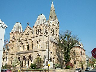
Williamsburg in Morrisons Cove, is a borough in Blair County, Pennsylvania, United States. The population was 1,241 at the 2020 census. It is part of the Altoona, PA Metropolitan Statistical Area.

<span class="mw-page-title-main">Bellefonte, Pennsylvania</span> Borough in Pennsylvania, United States

Bellefonte is a borough in, and the county seat of, Centre County, Pennsylvania, United States. It is approximately twelve miles northeast of State College and is part of the State College, Pennsylvania metropolitan statistical area. The borough population was 6,187 at the 2010 census. It houses the Centre County Courthouse, located downtown on the diamond. Bellefonte has also been home to five of Pennsylvania's governors, as well as two other governors. All seven are commemorated in a monument located at Talleyrand Park.

<span class="mw-page-title-main">State College, Pennsylvania</span> Home rule municipality in Pennsylvania, United States

State College is a home rule municipality in Centre County, Pennsylvania, United States. It is a college town, dominated economically, culturally, and demographically by the presence of the University Park campus of Penn State University.

The Pennsylvania Railroad, legal name The Pennsylvania Railroad Company, also known as the "Pennsy", was an American Class I railroad that was established in 1846 and headquartered in Philadelphia. It was named for the commonwealth in which it was established. At its peak in 1882, the Pennsylvania Railroad was the largest railroad, the largest transportation enterprise, and the largest corporation in the world.

<span class="mw-page-title-main">Horseshoe Curve (Pennsylvania)</span> Rail curve in Altoona, Pennsylvania

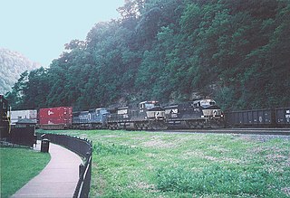
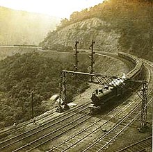
The Horseshoe Curve is a three-track railroad curve on Norfolk Southern Railway's Pittsburgh Line in Blair County, Pennsylvania. The curve is roughly 2,375 feet (700 m) long and 1,300 feet (400 m) in diameter. Completed in 1854 by the Pennsylvania Railroad as a way to reduce the westbound grade to the summit of the Allegheny Mountains, it replaced the time-consuming Allegheny Portage Railroad, which was the only other route across the mountains for large vehicles. The curve was later owned and used by three Pennsylvania Railroad successors: Penn Central, Conrail, and Norfolk Southern.

<span class="mw-page-title-main">Harrisburg Transportation Center</span> Intermodal station in Harrisburg, Pennsylvania

The Harrisburg Transportation Center is a railway station and transportation hub in Harrisburg, Pennsylvania. It is located on the eastern edge of Downtown Harrisburg between the intersections of Aberdeen and Market Streets and 4th and Chestnut Streets.

<span class="mw-page-title-main">Penn State Altoona</span> Public college in Logan Township, Pennsylvania, U.S.

Penn State Altoona is a commonwealth campus of The Pennsylvania State University located in Logan Township, Pennsylvania. It is one of four full-fledged four year institutions in the Commonwealth Campus network. The full-time student count was 2,577 in 2023.

<span class="mw-page-title-main">Altoona Area School District</span> School district in Pennsylvania

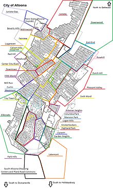
The Altoona Area School District is a large, urban, public school district based in Altoona, Pennsylvania. The school district encompasses 59.6 square miles (154 km2) which includes all of Altoona, Logan Township and a small portion of Tyrone Township.

Altoona Area High School (AAHS) is the public high school for the Altoona Area School District in Altoona, Pennsylvania. The high school serves the communities of Altoona, Logan Township, and a small portion of Tyrone Township.

<span class="mw-page-title-main">Altoona Transportation Center</span> Railroad and bus station in Altoona, Pennsylvania, US

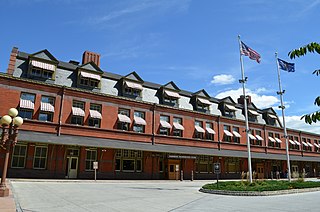
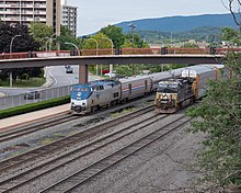
The Altoona Transportation Center is an intermodal passenger facility in downtown Altoona, Pennsylvania. It is served by the daily Amtrak Pennsylvanian, Greyhound Lines intercity buses, and AMTRAN local bus service. The station was built in 1986, replacing a temporary station, which had in turn replaced the 1887-built Pennsylvania Railroad station in 1972.

<span class="mw-page-title-main">Logansport, Indiana</span> City in Indiana, United States

Logansport is a city in and the county seat of Cass County, Indiana, United States. The population was 18,366 at the 2020 census. Logansport is located in northern Indiana at the junction of the Wabash and Eel rivers, northwest of Kokomo.

<span class="mw-page-title-main">Railroaders Memorial Museum</span> Railroad museum in Altoona, Pennsylvania

The Railroaders Memorial Museum (RMM) is a railroad museum in Altoona, Pennsylvania. The museum focuses on the history of railroad workers and railroad communities in central Pennsylvania, particularly Altoona, the Altoona Works, and the greater Pittsburgh area. Since 1998, the museum has been located in the Master Mechanics Building, built by the Pennsylvania Railroad in 1882. The museum also operates a separate museum, visitor center, and observation area at the Horseshoe Curve.

<span class="mw-page-title-main">Altoona Works</span> Railroad complex in Altoona, Pennsylvania, U.S.

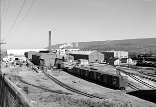
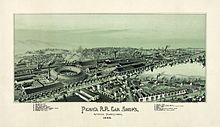
Altoona Works is a large railroad industrial complex in Altoona, Pennsylvania. It was built between 1850 and 1925 by the Pennsylvania Railroad (PRR), to supply the railroad with locomotives, railroad cars and related equipment. For many years, it was the largest railroad shop complex in the world.

<span class="mw-page-title-main">Pennsylvania Railroad 1361</span> Preserved PRR K4 class 4-6-2 locomotive

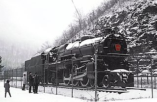
Pennsylvania Railroad 1361 is a 4-6-2 K4 "Pacific" type steam locomotive built in May 1918 by the Pennsylvania Railroad's (PRR) Juniata Shops in Altoona, Pennsylvania. It hauled mainline passenger trains in Pennsylvania and commuter trains in Central New Jersey on the PRR until its retirement from revenue service in 1956. Restored to operating condition for excursion service in 1987, No. 1361 and its only surviving sister locomotive, No. 3750, were designated as the official state steam locomotives by the Pennsylvania General Assembly. In 1988, it was sidelined due to mechanical problems and was currently owned by the Railroaders Memorial Museum (RMM) in Altoona, Pennsylvania, who were currently getting No. 1361 back to operation.

<span class="mw-page-title-main">Pittsburgh Line</span> Norfolk Southern rail line

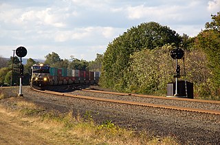
The Pittsburgh Line is the Norfolk Southern Railway's primary east–west artery in its Pittsburgh Division and Harrisburg Division across the U.S. state of Pennsylvania and is part of the Keystone Corridor, Amtrak-Norfolk Southern's combined rail corridor.

<span class="mw-page-title-main">UPMC Altoona</span> Hospital in Pennsylvania, U.S.

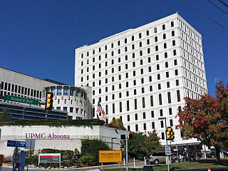
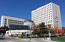
UPMC Altoona, located in downtown Altoona, Pennsylvania, is a 380-bed, non-profit, private community hospital system that contains more than 20 affiliated health care companies and functions as the regional referral center and tertiary hub of the University of Pittsburgh Medical Center (UPMC). Founded in 1883 as to serve the needs of the area and the Pennsylvania Railroad, the hospital was known for most of its history simply as Altoona Hospital. It became part of the Altoona Regional Health System which was created in 2004 by the merger of Altoona Hospital with Bon Secours-Holy Family Hospital, previously Mercy Hospital of Altoona. Today as part of UPMC, it is an Adult Level II trauma center for a 20 county region in central Pennsylvania and is served by 300 physicians and 4,000 care givers that help it to provide a variety of medical services and specialties.

<span class="mw-page-title-main">Muleshoe Curve</span>

Muleshoe Curve is a curve of track used by the former Pennsylvania Railroad (PRR) near Duncansville, Pennsylvania. Part of a secondary and frequently disused route, the curve is less well known than Horseshoe Curve, located 4.34 mi north.

Eldorado is an unincorporated community and census-designated place (CDP) in Blair County, Pennsylvania, United States. It was first listed as a CDP prior to the 2020 census.

References

  1. "Explore The Altoona Railroad Museum". Pennsylvania-mountains-of-attractions.com. Retrieved July 9, 2012.
  2. "Altoona City Council". City of Altoona, Pennsylvania. Archived from the original on November 8, 2015. Retrieved September 21, 2015.
  3. Kibler, William (November 2, 2013). "Altoona mayoral candidates newcomers to politics". Altoona Mirror. Retrieved September 21, 2015. Two political newcomers – and Altoona natives – are vying for the city mayor's chair in Tuesday's election: Republican Matt Pacifico and Democrat John Pentland.
  4. Kibler, William. "Pacifico secures mayoral re-election". Altoona Mirror. Retrieved July 9, 2020.
  5. "ArcGIS REST Services Directory". United States Census Bureau. Retrieved October 12, 2022.
  6. 1 2 U.S. Geological Survey Geographic Names Information System: Altoona, Pennsylvania
  7. 1 2 "Census Population API". United States Census Bureau. Retrieved October 12, 2022.
  8. "PHMC Historical Markers Search". Pennsylvania Historical and Museum Commission. Commonwealth of Pennsylvania. Archived from the original (Searchable database) on March 21, 2016. Retrieved January 25, 2014.
  9. United States Census Bureau, 2020 Census, Altoona, Pennsylvania
  10. United States Census Bureau, 2020 Census, Blair County
  11. "City of Altoona History". Altoona, Pennsylvania. Archived from the original on June 25, 2013. Retrieved September 8, 2013.
  12. "Peoples Natural Gas Field". MiLB.com. Retrieved June 28, 2023.
  13. "Altoona Symphony Orchestra". Archived from the original on September 26, 2007. Retrieved September 22, 2007.
  14. Gannett, Henry (1905). The origin of certain place names in the United States. Government Printing Office. p.  22.
  15. Espenshade, A. Howry: Pennsylvania Place Names, pp. 175–176. Genealogical Publishing Co, Inc., Baltimore, Maryland, 1970
  16. Africa, J. Simpson: History of Huntingdon and Blair Counties, Pennsylvania, page 135. J. B. Lippincott & Co. Philadelphia, 1883.
  17. Mandak, Joe. Associated Press, April 26, 2011, "Altoona, Pa., changes name to Spurlock movie title". Accessed February 27, 2019.
  18. "- History".
  19. "History of Altoona". I Love Altoona. Archived from the original on February 1, 2015. Retrieved September 8, 2013.
  20. "Event to revisit Nazi plot that ratcheted up security at Horseshoe Curve - AltoonaMirror.com - Altoona, PA | News, Sports, Jobs, Community Information - The Altoona Mirror". altoonamirror.com. Retrieved September 29, 2015.
  21. 1 2 "History of the Altoona Railroad Shops: The Creation And Coming Of The Pennsylvania Railroad". National Park Service Special History Study. United States National Park Service. October 22, 2004. Retrieved August 21, 2007.
  22. "Altoona Firefighters Local 299". Archived from the original on September 28, 2007. Retrieved September 22, 2007.
  23. 1 2 "Historical Society of Pennsylvania".
  24. "Altoona's Horseshoe Curve: A Must-See for Train Lovers". August 26, 2013.
  25. "Altoona Mirror Newspaper Archives | NewspaperArchive".
  26. "Image: us-tornado-map-1930-74-9x12.jpg, (3600 × 2709 px)". southwestcollection.files.wordpress.com. July 15, 2013. Retrieved September 29, 2015.
  27. "Altoona Mirror" . Retrieved September 22, 2007.
  28. "National Register of Historic Places - Blair County".
  29. "U.S.Post Office/Altoona". Central Pennsylvania Community Foundation. Archived from the original on November 5, 2013. Retrieved January 19, 2015.
  30. "NowData – NOAA Online Weather Data". National Oceanic and Atmospheric Administration. Retrieved August 7, 2021.
  31. "Station: Altoon Blair CO AP, PA". U.S. Climate Normals 2020: U.S. Monthly Climate Normals (1991-2020). National Oceanic and Atmospheric Administration. Retrieved August 7, 2021.
  32. "Pennsylvania State Clamatologist records 1926–1996". Pennsylvania State Climatologist. Retrieved June 30, 2021.
  33. "Census of Population and Housing: Decennial Censuses". United States Census Bureau . Retrieved March 4, 2012.
  34. "Incorporated Places and Minor Civil Divisions Datasets: Subcounty Resident Population Estimates: April 1, 2010 to July 1, 2012". Population Estimates. U.S. Census Bureau. Archived from the original on June 11, 2013. Retrieved December 11, 2013.
  35. "Census 2020".
  36. "Census 2010: Pennsylvania". Usatoday.Com. Retrieved July 9, 2012.
  37. "U.S. Census website". United States Census Bureau . Retrieved January 31, 2008.
  38. "Number of Sheetz locations in the USA in 2023". ScrapeHero. Retrieved October 13, 2023.
  39. "Historical League Names to Return in 2022". Minor League Baseball. March 16, 2022. Retrieved March 16, 2022.
  40. "RootsWeb Blair place names". Archived from the original on February 25, 2008. Retrieved December 3, 2007.
  41. Motorsport Memorial: Ray Keech, Retrieved 2007-07-24.
  42. "Altoona Area School District, Altoona PA". Aasdcat.com. Archived from the original on April 20, 2012. Retrieved July 9, 2012.
  43. "Altoona Area School District". Archived from the original on 28 September 2007. Retrieved 22 September 2007.
  44. "Penn State Fact Book". Budget.psu.edu. Retrieved January 7, 2015.
  45. "The Old Pennsylvania Mirror". StateCollege.com. December 28, 2017. Retrieved September 29, 2021.
  46. Amtrak (June 2, 2013). "Pennsylvanian On-Time Performance" . Retrieved June 2, 2013.
  47. "Contour Airlines Wins US Subsidies for Regional Routes".
  48. "Altoona City Council Meeting Minutes" (PDF). City of Altoona. January 14, 2015.