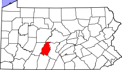
Mill Run, Pennsylvania | |
---|---|
Coordinates: 40°30′20″N78°25′55″W / 40.50556°N 78.43194°W | |
Country | United States |
State | Pennsylvania |
County | Blair |
Township | Logan |
Area | |
• Total | 0.30 sq mi (0.78 km2) |
• Land | 0.30 sq mi (0.78 km2) |
• Water | 0.00 sq mi (0.00 km2) |
Elevation | 1,253 ft (382 m) |
Population | |
• Total | 231 |
• Density | 764.90/sq mi (295.30/km2) |
Time zone | UTC-5 (Eastern (EST)) |
• Summer (DST) | UTC-4 (EDT) |
ZIP Code | 16601 (Altoona) |
Area code(s) | 814/582 |
FIPS code | 42-49848 |
GNIS feature ID | 2805524 [2] |
Mill Run is an unincorporated community and census-designated place (CDP) in Blair County, Pennsylvania, United States. It was first listed as a CDP prior to the 2020 census. [2]
The CDP is in western Blair County, south of the center of Logan Township. It is bordered to the east by the city of Altoona and is often considered a neighborhood of the city. The community is in the valley of Mill Run, a stream which comes off the Allegheny Front 2 miles (3 km) to the west and flows southeast, then south, to join Beaverdam Creek west of Hollidaysburg. Allegheny Reservoir is just west of the CDP, and Mill Run Reservoir is 1 mile (1.6 km) upstream. Mill Run is part of the watershed of the Frankstown Branch Juniata River, leading to the Susquehanna.
Census | Pop. | Note | %± |
---|---|---|---|
2020 | 231 | — | |
U.S. Decennial Census [4] |
The school district is Altoona Area School District. [5] Altoona Area High School is the comprehensive high school.
Blair County is a county in the Commonwealth of Pennsylvania. As of the 2020 census, the population was 122,822. Its county seat is Hollidaysburg, and its largest city is Altoona. The county was created on February 26, 1846, from parts of Huntingdon and Bedford counties. The county is part of the Southwest Pennsylvania region of the state.
Cresson is a borough in Cambria County, Pennsylvania, United States. Cresson is 80 miles (130 km) east of Pittsburgh. It is above 2,000 feet (600 m) in elevation. Lumber, coal, and coke yards were industries that had supported the population, which numbered 1,470 in 1910. The borough is part of the Johnstown Metropolitan Statistical Area, although state and local sources list it as part of the Altoona area due to being much closer to that city. The population of Cresson at the 2010 census was 1,711.
Lakemont is a census-designated place in Allegheny and Logan Townships in Blair County, Pennsylvania, United States. It is located to the east of I-99 and is located between Altoona and Hollidaysburg. Lakemont is the location of Lakemont Park, although the address is generally Altoona and part of the "Lakemont" area actually lies within the Altoona city boundaries. As of the 2010 census, the population was 1,868 residents.
Canan Station is an unincorporated community and census-designated place (CDP) in Blair County, Pennsylvania, United States. It was first listed as a CDP prior to the 2020 census. The community is also known as Canan.
Carson Valley is an unincorporated community and census-designated place (CDP) in Blair County, Pennsylvania, United States. It was first listed as a CDP prior to the 2020 census.
Charlottsville is an unincorporated community and census-designated place (CDP) in Blair County, Pennsylvania, United States. It was first listed as a CDP prior to the 2020 census.
Cross Keys is an unincorporated community and census-designated place (CDP) in Blair County, Pennsylvania, United States. It was first listed as a CDP prior to the 2020 census.
East Altoona is an unincorporated community and census-designated place (CDP) in Blair County, Pennsylvania, United States. It was first listed as a CDP prior to the 2020 census.
Elberta is an unincorporated community and census-designated place (CDP) in Blair County, Pennsylvania, United States. It was first listed as a CDP prior to the 2020 census.
Eldorado is an unincorporated community and census-designated place (CDP) in Blair County, Pennsylvania, United States. It was first listed as a CDP prior to the 2020 census.
Juniata Gap is an unincorporated community and census-designated place (CDP) in Blair County, Pennsylvania, United States. It was first listed as a CDP prior to the 2020 census.
Leamersville is an unincorporated community and census-designated place (CDP) in Blair County, Pennsylvania, United States. It was first listed as a CDP prior to the 2020 census.
Newburg is an unincorporated community and census-designated place (CDP) in Blair County, Pennsylvania, United States. It was first listed as a CDP prior to the 2020 census.
Pinecroft is an unincorporated community and census-designated place (CDP) in Blair County, Pennsylvania, United States. It was first listed as a CDP prior to the 2020 census.
Red Hill is an unincorporated community and census-designated place (CDP) in Blair County, Pennsylvania, United States. It was first listed as a CDP prior to the 2020 census.
Reightown is an unincorporated community and census-designated place (CDP) in Blair County, Pennsylvania, United States. It was first listed as a CDP prior to the 2020 census.
Roots is an unincorporated community and census-designated place (CDP) in Blair County, Pennsylvania, United States. It was first listed as a CDP prior to the 2020 census.
Sickles Corner is an unincorporated community and census-designated place (CDP) in Blair County, Pennsylvania, United States. It was first listed as a CDP prior to the 2020 census.
Sunbrook is an unincorporated community and census-designated place (CDP) in Blair County, Pennsylvania, United States. It was first listed as a CDP prior to the 2020 census.
Wopsononock is an unincorporated community and census-designated place (CDP) in Blair County, Pennsylvania, United States. It was first listed as a CDP prior to the 2020 census.