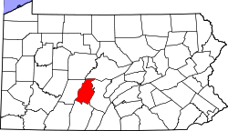
East Altoona, Pennsylvania | |
---|---|
Coordinates: 40°32′49″N78°21′49″W / 40.54694°N 78.36361°W | |
Country | United States |
State | Pennsylvania |
County | Blair |
Township | Logan |
Area | |
• Total | 0.26 sq mi (0.67 km2) |
• Land | 0.26 sq mi (0.67 km2) |
• Water | 0.00 sq mi (0.00 km2) |
Elevation | 1,152 ft (351 m) |
Population | |
• Total | 351 |
• Density | 1,350.00/sq mi (520.65/km2) |
Time zone | UTC-5 (Eastern (EST)) |
• Summer (DST) | UTC-4 (EDT) |
ZIP Code | 16601 (Altoona) |
Area code(s) | 814/582 |
FIPS code | 42-20752 |
GNIS feature ID | 2805490 [2] |
East Altoona is an unincorporated community and census-designated place (CDP) in Blair County, Pennsylvania, United States. It was first listed as a CDP prior to the 2020 census. [2]
The CDP is in western Blair County, in the northeastern part of Logan Township. It is in Logan Valley, on the east side of the Little Juniata River, 2.5 miles (4.0 km) northeast of the center of Altoona. Greenwood is 1 mile (1.6 km) to the east, in the neighboring valley of Sandy Run, and Pinecroft is 2 miles (3 km) to the north in Antis Township.
The East Altoona Roundhouse, the largest locomotive-servicing roundhouse in the world in the early 20th century, was located 1 mile (1.6 km) southwest of the current CDP, just outside the Altoona city limits.
Census | Pop. | Note | %± |
---|---|---|---|
2020 | 351 | — | |
U.S. Decennial Census [4] |
Blair County is a county in the Commonwealth of Pennsylvania. As of the 2020 census, the population was 122,822. Its county seat is Hollidaysburg, and its largest city is Altoona. The county was created on February 26, 1846, from parts of Huntingdon and Bedford counties. The county is part of the Southwest Pennsylvania region of the state.
Canan Station is an unincorporated community and census-designated place (CDP) in Blair County, Pennsylvania, United States. It was first listed as a CDP prior to the 2020 census. The community is also known as Canan.
Carson Valley is an unincorporated community and census-designated place (CDP) in Blair County, Pennsylvania, United States. It was first listed as a CDP prior to the 2020 census.
Charlottsville is an unincorporated community and census-designated place (CDP) in Blair County, Pennsylvania, United States. It was first listed as a CDP prior to the 2020 census.
Cotton Town is an unincorporated community and census-designated place (CDP) in Blair County, Pennsylvania, United States. It was first listed as a CDP prior to the 2020 census.
Cross Keys is an unincorporated community and census-designated place (CDP) in Blair County, Pennsylvania, United States. It was first listed as a CDP prior to the 2020 census.
Elberta is an unincorporated community and census-designated place (CDP) in Blair County, Pennsylvania, United States. It was first listed as a CDP prior to the 2020 census.
Eldorado is an unincorporated community and census-designated place (CDP) in Blair County, Pennsylvania, United States. It was first listed as a CDP prior to the 2020 census.
Fort Fetters is a neighborhood and census-designated place (CDP) in Blair County, Pennsylvania, United States. It was first listed as a CDP prior to the 2020 census.
Geeseytown is an unincorporated community and census-designated place (CDP) in Blair County, Pennsylvania, United States. It was first listed as a CDP prior to the 2020 census.
Juniata Gap is an unincorporated community and census-designated place (CDP) in Blair County, Pennsylvania, United States. It was first listed as a CDP prior to the 2020 census.
Leamersville is an unincorporated community and census-designated place (CDP) in Blair County, Pennsylvania, United States. It was first listed as a CDP prior to the 2020 census.
Linds Crossing is a census-designated place (CDP) in Blair County, Pennsylvania, United States. Comprising the unincorporated communities of Linds Crossing and Upper Reese, it was first listed as a CDP prior to the 2020 census.
Mill Run is an unincorporated community and census-designated place (CDP) in Blair County, Pennsylvania, United States. It was first listed as a CDP prior to the 2020 census.
Newburg is an unincorporated community and census-designated place (CDP) in Blair County, Pennsylvania, United States. It was first listed as a CDP prior to the 2020 census.
Pinecroft is an unincorporated community and census-designated place (CDP) in Blair County, Pennsylvania, United States. It was first listed as a CDP prior to the 2020 census.
Penn Farms is an unincorporated community and census-designated place (CDP) in Blair County, Pennsylvania, United States. It was first listed as a CDP prior to the 2020 census.
Red Hill is an unincorporated community and census-designated place (CDP) in Blair County, Pennsylvania, United States. It was first listed as a CDP prior to the 2020 census.
Reightown is an unincorporated community and census-designated place (CDP) in Blair County, Pennsylvania, United States. It was first listed as a CDP prior to the 2020 census.
Wopsononock is an unincorporated community and census-designated place (CDP) in Blair County, Pennsylvania, United States. It was first listed as a CDP prior to the 2020 census.