Tipton, Pennsylvania | |
---|---|
Coordinates: 40°38′8″N78°17′53″W / 40.63556°N 78.29806°W | |
Country | United States |
State | Pennsylvania |
County | Blair |
Township | Antis |
Area | |
• Total | 1.02 sq mi (2.64 km2) |
• Land | 1.02 sq mi (2.64 km2) |
• Water | 0.00 sq mi (0.0 km2) |
Elevation | 997 ft (304 m) |
Population | |
• Total | 826 |
• Density | 809.01/sq mi (312.32/km2) |
Time zone | UTC-5 (Eastern (EST)) |
• Summer (DST) | UTC-4 (EDT) |
ZIP code | 16684 [4] |
Area code | 814 |
FIPS code | 42-76880 |
GNIS feature ID | 2390393 [2] |
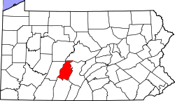
Tipton is a census-designated place (CDP) in Antis Township, Blair County, Pennsylvania, United States. The population was 1,083 at the 2010 census. It was a stop on the former Pennsylvania Railroad Main Line between Tyrone and Altoona.
According to the United States Census Bureau, the CDP has a total area of 1.9 square miles (4.9 km2), all land.
There are four unique sections to the Tipton area. The Poe, The Pellegrine, The Noel, and The Tilly regions, all named after the first settlers in the area. The Poe region consists of the north-eastern area, the Pellegrine region consists of the southern houses and apartments, and the Noel region consists of a small portion of land to the north-western area in which notable landmarks, such as the Tipton Recreation Center, are located. The Tilly region overlaps with the other three regions, and consists of most of the factory and manufacturing buildings.
Census | Pop. | Note | %± |
---|---|---|---|
2020 | 826 | — | |
U.S. Decennial Census [5] [3] |
As of the census [6] of 2000, there were 1,225 people, 463 households, and 356 families residing in the CDP. The population density was 663.9 inhabitants per square mile (256.3/km2). There were 478 housing units at an average density of 259.1 per square mile (100.0/km2). The racial makeup of the CDP was 99.10% White, 0.16% African American, 0.41% Native American, and 0.33% from two or more races. Hispanic or Latino of any race were 0.33% of the population.
There were 463 households, out of which 33.5% had children under the age of 18 living with them, 67.4% were married couples living together, 5.6% had a female householder with no husband present, and 23.1% were non-families. 19.2% of all households were made up of individuals, and 8.9% had someone living alone who was 65 years of age or older. The average household size was 2.65 and the average family size was 3.03.
In the CDP, the population was spread out, with 23.8% under the age of 18, 7.3% from 18 to 24, 28.7% from 25 to 44, 25.0% from 45 to 64, and 15.2% who were 65 years of age or older. The median age was 40 years. For every 100 females, there were 100.8 males. For every 100 females age 18 and over, there were 101.9 males.
The median income for a household in the CDP was $51,250, and the median income for a family was $59,100. Males had a median income of $37,596 versus $28,359 for females. The per capita income for the CDP was $21,320. About 6.0% of families and 12.0% of the population were below the poverty line, including 19.9% of those under age 18 and 13.5% of those age 65 or over.
Desert Hills is an unincorporated community and census-designated place (CDP) in Mohave County, Arizona, United States. The population was 2,764 at the 2020 census, up from 2,245 at the 2010 census.
Tipton is a census-designated place (CDP) in Tulare County, California, United States. The population was 2,543 at the 2010 census, up from 1,790 at the 2000 census.
Taft is a census-designated place and an unincorporated area in Orange County, Florida, United States. The population was 2,205 at the 2010 census. It is part of the Orlando–Kissimmee Metropolitan Statistical Area.
Ingalls Park is an unincorporated community, census-designated place (CDP), and suburb of Joliet in Will County, Illinois, United States. The population was 3,314 at the 2010 census. The town consists of a small neighborhood and a few businesses between Joliet's Pilcher Park and Interstate 80. It is the nearest town to Chicagoland Speedway, which hosted the NASCAR Cup Series from 2001 to 2019.
Morrisonville is a hamlet and census-designated place in Clinton County, New York, United States. The population was 1,545 at the 2010 census.
Beaverdale is an unincorporated community and census-designated place (CDP) in Cambria County, Pennsylvania, United States. The population was 1,035 at the 2010 census. Prior to that time, the CDP was known as Beaverdale-Lloydell.
Belmont is an unincorporated community and census-designated place (CDP) in Cambria County, Pennsylvania, United States. The population was 2,784 at the 2010 census.
Spring Hill is a census-designated place (CDP) in Cambria County, Pennsylvania, United States. The population was 839 at the 2010 census, down from 970 at the 2000 census.
Coburn is a census-designated place (CDP) in Centre County, Pennsylvania, United States. It is part of the State College, Pennsylvania Metropolitan Statistical Area. The population was 236 at the 2010 census.
New Kingstown is a census-designated place (CDP) in Silver Spring Township, Cumberland County, Pennsylvania, United States. The population was 495 at the 2010 census. It is part of the Harrisburg–Carlisle metropolitan statistical area.
Guilford is a census-designated place (CDP) in Franklin County, Pennsylvania, United States. The population was 2,923 at the 2020 census.
New Castle Northwest is an unincorporated area and census-designated place (CDP) in Lawrence County, Pennsylvania, United States. The population was 1,413 at the 2010 census.
Brodheadsville is a census-designated place (CDP) in Monroe County, Pennsylvania, United States. The population was 1,700 at the 2020 census. The community is served by Pleasant Valley School District.
Blue Bell is a census-designated place (CDP) in Whitpain Township, Pennsylvania, United States. As of the 2010 census, its population was 6,067.
Montgomeryville is a census-designated place (CDP) in Montgomery Township, Montgomery County, Pennsylvania, United States. The population was 12,624 at the 2010 census. According to a 2010 Forbes magazine/Yahoo.com survey, Montgomeryville ranks 5th in America's top 10 affordable suburbs. It is part of the North Penn Valley region that is centered on the borough of Lansdale.
Klingerstown is a census-designated place (CDP) in Upper Mahantongo Township, Schuylkill County, Pennsylvania, United States. As of the 2000 census, the CDP population was 102.
Emigsville is a census-designated place (CDP) in York County, Pennsylvania, United States. The population was 3,563 at the 2020 census.
Wiley Ford is a census-designated place (CDP) in Mineral County, West Virginia, United States and part of the 'Cumberland, MD-WV Metropolitan Statistical Area'. The population was 1,026 at the 2010 census.
Lynnwood-Pricedale is a census-designated place (CDP) in Fayette and Westmoreland counties in the Pennsylvania. The population was 2,031 at the 2010 census, down from 2,168 at the 2000 census. The community of Lynwood is located in Fayette County's Washington Township, while Pricedale is part of Westmoreland County's Rostraver Township.
Barre is a census-designated place (CDP) in the town of Barre in Worcester County, Massachusetts, United States. The population was 1,009 at the 2010 census.