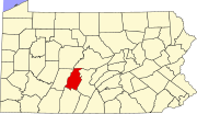
Yellow Springs is a populated place in Blair County, Pennsylvania, United States, [1] with the zip code 16693. [2]
Blair County is a county in the Commonwealth of Pennsylvania. As of the 2020 census, the population was 122,822. Its county seat is Hollidaysburg. The county was created on February 26, 1846, from parts of Huntingdon and Bedford counties.
Catharine Township is a township in Blair County, Pennsylvania, United States. The population was 774 at the 2020 census. It is part of the Altoona, PA Metropolitan Statistical Area.
Huston Township is a township in Blair County, Pennsylvania, United States. It is part of the Altoona, PA Metropolitan Statistical Area. The population was 1,251 at the 2020 census.
Logan Township is a township in Blair County, Pennsylvania, United States. It is part of the Altoona, PA Metropolitan Statistical Area. It is the most populous township in Blair County, with a population of 12,413 at the 2020 census. Logan Township is home to Horseshoe Curve, a National Historic Landmark.
North Woodbury Township is a township in Blair County, Pennsylvania, United States. It is part of the Altoona, PA Metropolitan Statistical Area. The population was 2,429 at the 2020 census.
Taylor Township is a township in Blair County, Pennsylvania, United States. It is part of the Altoona, PA Metropolitan Statistical Area. The population was 2,306 at the 2020 census.
Tyrone Township is a township in Blair County, Pennsylvania, United States. It is part of the Altoona, PA Metropolitan Statistical Area. The population was 1,882 at the 2020 census.
Portage Township is a township in Cambria County, Pennsylvania, United States. It surrounds the borough of Portage. The township population was 3,640 at the 2010 census. It is part of the Johnstown, Pennsylvania Metropolitan Statistical Area.
Madisonburg is an unincorporated community and census-designated place (CDP) in Miles Township, Centre County, Pennsylvania, United States. It is part of the State College, Pennsylvania Metropolitan Statistical Area. The population was 168 at the 2010 census.
Tunnelhill is a borough that is located in Cambria and Blair counties in Pennsylvania, United States. The population was 363 at the 2010 census. Of these, 245 were in Cambria County, and 118 were in Blair County. It is part of the Altoona, PA Metropolitan Statistical Area. Tunnelhill is named after the many railroad tunnels of the Pennsylvania Railroad near here known as the Gallitzin Tunnels.
Puzzletown is an unincorporated community and census-designated place (CDP) in Blair County, Pennsylvania, United States.
Bald Eagle Creek is a 9.4-mile-long (15.1 km) tributary of the Little Juniata River in Blair County, Pennsylvania, in the United States. It runs southwest through the Bald Eagle Valley at the foot of the Bald Eagle Mountain ridge to Tyrone.
The Frankstown Branch Juniata River is a 46.0-mile-long (74.0 km) tributary of the Juniata River in Blair and Huntingdon counties, Pennsylvania, in the United States.
Morrisons Cove, is an eroded anticlinal valley in Blair and Bedford counties of central Pennsylvania, United States, extending from Evitts Mountain near New Enterprise, north to the Frankstown Branch Juniata River at Williamsburg. The width of the valley varies from 10 to 15 miles between Tussey Mountain on the east to the chain of Dunning, Loop and Lock Mountains on the west. Almost entirely enclosed by these mountains, the only openings in the cove are at Loysburg Gap in the south, McKee Gap in the west, and at Williamsburg to the north. The floor of the valley is mostly level, with many large fertile farm fields. The southern end of the valley drains to the Raystown Branch Juniata River via Yellow Creek through Loysburg Gap, and the northern end drains to the Frankstown Branch, via Clover Creek.
Bald Eagle is an unincorporated populated place in Blair County, Pennsylvania, United States. It is located in the Bald Eagle Valley at the foot of the Bald Eagle Mountain ridge, along the Big Fill Run near its confluence with the headwaters of the Bald Eagle Creek tributary of the Little Juniata River. Originally a stop on the Pennsylvania Railroad Tyrone Division, it is now exit 52 off Interstate 99, and was the former northern terminus of the unfinished highway. The Bald Eagle postal zip code is 16686.
McGee's Crossroads is an unincorporated community in Johnston County, North Carolina, United States, situated at the intersection of North Carolina Highway 50, and North Carolina Highway 210. It lies at an elevation of 292 feet.
East Freedom is a census-designated place (CDP) in Freedom Township, Blair County, Pennsylvania, United States. It is located near I-99 and is approximately four miles to the west of the borough of Roaring Spring. As of the 2010 census, the population was 972 residents.
Halter Creek is a 9.5-mile-long (15.3 km) tributary of the Frankstown Branch of the Juniata River in Bedford and Blair counties, Pennsylvania, in the United States.
Culp is an unincorporated community located in Tyrone Township, Blair County, Pennsylvania, United States. It is located on Kettle Road at the intersection with Golf Course Road.
The Pennsylvania State Game Lands Number 26 are Pennsylvania State Game Lands in Bedford, Blair, Cambria, and Somerset Counties in Pennsylvania in the United States providing hunting, bird watching, equestrian, snowmobiling, and other activities.
Coordinates: 40°31′02″N78°12′24″W / 40.51722°N 78.20667°W