Klahr, Pennsylvania | |
---|---|
Coordinates: 40°17′52″N78°30′45″W / 40.29778°N 78.51250°W | |
Country | United States |
State | Pennsylvania |
County | Blair |
Township | Greenfield |
Area | |
• Total | 0.14 sq mi (0.35 km2) |
• Land | 0.14 sq mi (0.35 km2) |
• Water | 0.00 sq mi (0.00 km2) |
Elevation | 1,624 ft (495 m) |
Population | |
• Total | 76 |
• Density | 562.96/sq mi (217.00/km2) |
Time zone | UTC-5 (Eastern (EST)) |
• Summer (DST) | UTC-4 (EDT) |
ZIP Code | 16625 (Claysburg) |
Area code(s) | 814/582 |
FIPS code | 42-40072 |
GNIS feature ID | 2805516 [2] |
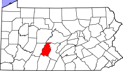
Klahr is an unincorporated community and census-designated place (CDP) in Blair County, Pennsylvania, United States. It was first listed as a CDP prior to the 2020 census. [2]
The CDP is in southwestern Blair County, in the southern part of Greenfield Township. It sits at the head of the valley of Smoky Run, at the base of Spruce Knob, an eastern spur of Blue Knob, the second-highest summit in Pennsylvania. Smoky Run is a southeastward-flowing tributary of Beaverdam Creek, one of the main headwater tributaries of the Frankstown Branch of the Juniata River, part of the Susquehanna River watershed.
Locust Hollow Road is the main street through Klahr, leading north 2 miles (3 km) to Ski Gap and southeast 2.5 miles (4.0 km) to Cotton Town. Claysburg is 5 miles (8 km) by road to the east, and Hollidaysburg is 20 miles (32 km) to the northeast.
Census | Pop. | Note | %± |
---|---|---|---|
2020 | 76 | — | |
U.S. Decennial Census [4] |
Landisville is an unincorporated community and census-designated place (CDP) in East Hempfield Township, Lancaster County, Pennsylvania, United States. As of the 2010 census the population was 1,893. The community was once part of the Salunga-Landisville CDP, before splitting into two separate CDPs for the 2010 census, the other being Salunga.
Lampeter is an unincorporated community and census-designated place (CDP) in West Lampeter Township, Lancaster County, Pennsylvania, United States. As of the 2010 census, it had a population of 1,669. It is a suburb of Lancaster and has a ZIP code of 17537. The community was named after Lampeter, in Wales.
Frizzleburg is an unincorporated community and census-designated place (CDP) in Lawrence County, Pennsylvania, United States. The population was 602 at the 2010 census.
Little Britain is an unincorporated community and census-designated place (CDP) in Little Britain Township, Lancaster County, Pennsylvania, United States. At the 2010 census, the population was 372.
Beavertown is an unincorporated community and census-designated place (CDP) in Blair County, Pennsylvania, United States. It was first listed as a CDP prior to the 2020 census.
Blue Knob is an unincorporated community and census-designated place (CDP) in Blair County, Pennsylvania, United States. It was first listed as a CDP prior to the 2020 census.
Cotton Town is an unincorporated community and census-designated place (CDP) in Blair County, Pennsylvania, United States. It was first listed as a CDP prior to the 2020 census.
East Altoona is an unincorporated community and census-designated place (CDP) in Blair County, Pennsylvania, United States. It was first listed as a CDP prior to the 2020 census.
Elberta is an unincorporated community and census-designated place (CDP) in Blair County, Pennsylvania, United States. It was first listed as a CDP prior to the 2020 census.
Fort Fetters is a neighborhood and census-designated place (CDP) in Blair County, Pennsylvania, United States. It was first listed as a CDP prior to the 2020 census.
Ganister is an unincorporated community and census-designated place (CDP) in Blair County, Pennsylvania, United States. It was first listed as a CDP prior to the 2020 census.
Geeseytown is an unincorporated community and census-designated place (CDP) in Blair County, Pennsylvania, United States. It was first listed as a CDP prior to the 2020 census.
Henrietta is an unincorporated community and census-designated place (CDP) in Blair County, Pennsylvania, United States. It was first listed as a CDP prior to the 2020 census.
Larke is an unincorporated community and census-designated place (CDP) in Blair County, Pennsylvania, United States. It was first listed as a CDP prior to the 2020 census.
McKee is an unincorporated community and census-designated place (CDP) in Blair County, Pennsylvania, United States. It was first listed as a CDP prior to the 2020 census.
Millerstown is an unincorporated community and census-designated place (CDP) in Blair County, Pennsylvania, United States. It was first listed as a CDP prior to the 2020 census.
Moores Mill is a census-designated place (CDP) in Blair County, Pennsylvania, United States. It was first listed as a CDP prior to the 2020 census.
Olivia is an unincorporated community and census-designated place (CDP) in Blair County, Pennsylvania, United States. It was first listed as a CDP prior to the 2020 census.
Moose Run is a census-designated place (CDP) in Centre County, Pennsylvania, United States. It was first listed as a CDP prior to the 2020 census.
Runville is an unincorporated community and census-designated place (CDP) in Centre County, Pennsylvania, United States. It was first listed as a CDP prior to the 2020 census.