Blue Knob, Pennsylvania

Last updated

Blue Knob, Pennsylvania
USA Pennsylvania location map.svg
Red pog.svg
Blue Knob
Usa edcp location map.svg
Red pog.svg
Blue Knob
Coordinates: 40°21′18″N78°33′11″W / 40.35500°N 78.55306°W / 40.35500; -78.55306
CountryUnited States
State Pennsylvania
County Blair
Township Juniata
Area
[1]
  Total0.09 sq mi (0.23 km2)
  Land0.09 sq mi (0.23 km2)
  Water0.00 sq mi (0.00 km2)
Elevation
2,370 ft (720 m)
Population
 (2020) [2]
  Total56
  Density615.38/sq mi (238.80/km2)
Time zone UTC-5 (Eastern (EST))
  Summer (DST) UTC-4 (EDT)
ZIP Codes
15946 (Portage)
16635 (Duncansville)
Area codes 814/582
FIPS code 42-07272
GNIS feature ID2805467 [3]

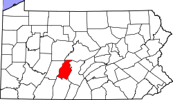
Blue Knob is an unincorporated community and census-designated place (CDP) in Blair County, Pennsylvania, United States. It was first listed as a CDP prior to the 2020 census. [3]

The CDP is in southwestern Blair County, at the southern end of Juniata Township. It stands atop the Allegheny Front at 2,370 feet (720 m) elevation, approximately 1 mile (1.6 km) southeast of the Eastern Continental Divide. Pennsylvania Route 164 passes through the community, leading east down the Front 7 miles (11 km) to East Freedom and west 8 miles (13 km) to Portage. Knob Road leads south from the CDP 5 miles (8 km) to Blue Knob State Park, atop Blue Knob, the second-highest peak in Pennsylvania.

Demographics

Historical population
CensusPop.Note
2020 56
U.S. Decennial Census [4] [2]

Related Research Articles

<span class="mw-page-title-main">Claysburg, Pennsylvania</span> Census-designated place in Pennsylvania, United States

Claysburg is a census-designated place (CDP) along Interstate 99 and the Allegheny Front in Blair County, Pennsylvania, United States, situated near the base of Blue Knob. As of the 2020 census, it had a population of 1,291.

<span class="mw-page-title-main">Beaverdale, Pennsylvania</span> Census-designated place in Pennsylvania, United States

Beaverdale is an unincorporated community and census-designated place (CDP) in Cambria County, Pennsylvania, United States. The population was 1,035 at the 2010 census. Prior to that time, the CDP was known as Beaverdale-Lloydell.

Leola is a census-designated place (CDP) in Lancaster County, Pennsylvania, United States. It includes the unincorporated communities of Leola, Leacock, and Bareville, and prior to 2010 was known as the Leacock-Leola-Bareville census-designated place. Originally named "Mechanicsburg", its present name is a portmanteau of "Leacock" and the "Glenola" train station that once served the town. As of the 2010 census, the population of the CDP was 7,214.

Fort Loudon (CDP) is an unincorporated community and census-designated place (CDP) in Peters Township, Franklin County, Pennsylvania, United States. As of the 2020 census, the population was 895.

East Sharpsburg is an unincorporated community and census-designated place (CDP) in Blair County, Pennsylvania, United States. It was first listed as a CDP prior to the 2020 census.

Beavertown is an unincorporated community and census-designated place (CDP) in Blair County, Pennsylvania, United States. It was first listed as a CDP prior to the 2020 census.

Brooks Mill is an unincorporated community and census-designated place (CDP) in Blair County, Pennsylvania, United States. It was first listed as a CDP prior to the 2020 census.

Carson Valley is an unincorporated community and census-designated place (CDP) in Blair County, Pennsylvania, United States. It was first listed as a CDP prior to the 2020 census.

Cross Keys is an unincorporated community and census-designated place (CDP) in Blair County, Pennsylvania, United States. It was first listed as a CDP prior to the 2020 census.

East Altoona is an unincorporated community and census-designated place (CDP) in Blair County, Pennsylvania, United States. It was first listed as a CDP prior to the 2020 census.

Eldorado is an unincorporated community and census-designated place (CDP) in Blair County, Pennsylvania, United States. It was first listed as a CDP prior to the 2020 census.

Friesville is an unincorporated community and census-designated place (CDP) in Blair County, Pennsylvania, United States. It was first listed as a CDP prior to the 2020 census.

Klahr is an unincorporated community and census-designated place (CDP) in Blair County, Pennsylvania, United States. It was first listed as a CDP prior to the 2020 census.

Leamersville is an unincorporated community and census-designated place (CDP) in Blair County, Pennsylvania, United States. It was first listed as a CDP prior to the 2020 census.

Mill Run is an unincorporated community and census-designated place (CDP) in Blair County, Pennsylvania, United States. It was first listed as a CDP prior to the 2020 census.

Moores Mill is a census-designated place (CDP) in Blair County, Pennsylvania, United States. It was first listed as a CDP prior to the 2020 census.

Newburg is an unincorporated community and census-designated place (CDP) in Blair County, Pennsylvania, United States. It was first listed as a CDP prior to the 2020 census.

Oreminea is an unincorporated community and census-designated place (CDP) in Blair County, Pennsylvania, United States. It was first listed as a CDP prior to the 2020 census.

Point View is an unincorporated community and census-designated place (CDP) in Blair County, Pennsylvania, United States. It was first listed as a CDP prior to the 2020 census.

Ski Gap is a census-designated place (CDP) in Blair County, Pennsylvania, United States. It was first listed as a CDP prior to the 2020 census. The CDP corresponds to the unincorporated community of Fredericksburg, not to be confused with the Fredericksburg in the eastern part of Blair County.

References

  1. "ArcGIS REST Services Directory". United States Census Bureau. Retrieved October 12, 2022.
  2. 1 2 "Census Population API". United States Census Bureau. Retrieved October 12, 2022.
  3. 1 2 "Blue Knob Census Designated Place". Geographic Names Information System . United States Geological Survey, United States Department of the Interior.
  4. "Census of Population and Housing". Census.gov. Retrieved June 4, 2016.