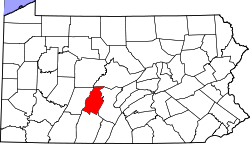
Culp is an unincorporated community and census-designated place located in Tyrone Township, Blair County, Pennsylvania, United States. [1] It is located on Kettle Road (Route 1013) at the intersection with Golf Course Road (Route 1015). [2]
Culp is less than one mile to the east of historic Fort Roberdeau, and approximately 2.5 miles southwest of Tytoona Cave. It is located in Sinking Valley and is near Skelp, another small unincorporated community. Sinking Run flows through Culp.[ citation needed ]
Blair County is a county in the Commonwealth of Pennsylvania. As of the 2020 census, the population was 122,822. Its county seat is Hollidaysburg, and its largest city is Altoona. The county was created on February 26, 1846, from parts of Huntingdon and Bedford counties. The county is part of the Southwest Pennsylvania region of the state.
Berlin Charter Township is a charter township of Monroe County in the U.S. state of Michigan. At the 2020 census, the township population was 9,890.
Blair Township is a township in Blair County, Pennsylvania, United States. The population was 4,785 at the 2020 census.
Catharine Township is a township in Blair County, Pennsylvania, United States. The population was 773 at the 2020 census. It is part of the Altoona, PA Metropolitan Statistical Area.
Frankstown Township is a township in Blair County, Pennsylvania, United States. It is part of the Altoona Metropolitan Statistical Area. The population was 7,399 at the 2020 census. The township was named after Stephen Franks, a pioneer citizen.
Greenfield Township is a township in Blair County, Pennsylvania, United States. It is part of the Altoona, PA Metropolitan Statistical Area. The population was 3,785 at the 2020 census.
Logan Township is a township in Blair County, Pennsylvania, United States. It is part of the Altoona, PA Metropolitan Statistical Area. It is the most populous township in Blair County, with a population of 12,413 at the 2020 census. Logan Township is home to Horseshoe Curve, a National Historic Landmark.
Snyder Township is a township in Blair County, Pennsylvania, United States. It is part of the Altoona, PA Metropolitan Statistical Area. The population was 3,345 at the 2020 census.
Tyrone Township is a township in Blair County, Pennsylvania, United States. It is part of the Altoona, PA Metropolitan Statistical Area. The population was 1,873 at the 2020 census.
Dean Township is a township in Cambria County, Pennsylvania, United States. The population was 391 at the 2010 census. It is part of the Johnstown, Pennsylvania Metropolitan Statistical Area despite being much closer to Altoona.
Dysart is an unincorporated community located in Dean Township, Cambria County, Pennsylvania, United States.
Fritztown is an unincorporated community in South Heidelberg and Spring Township, Berks County, Pennsylvania, United States. It is located along Fritztown Road to the west of U.S. Route 222 and approximately two miles northeast of the Berks and Lancaster County line and 3.4 miles southwest of Sinking Spring. The Cacoosing Creek begins here and drains northeastward into the Tulpehocken Creek, a tributary of the Schuylkill River. The area is experiencing population growth, due to new sub-divisions being built around the community. It is served by the Sinking Spring branch of the Reading post office, with the zip code of 19608.
Arch Springs is an unincorporated community located in Tyrone Township, Blair County, Pennsylvania. It is located on Kettle Road approximately 0.3 miles to the south of Hileman Road. Sinking Run flows through the community, and the Arch Spring itself is located on the creek.
Skelp is an unincorporated community and Census-designated place located in Tyrone Township, Blair County, Pennsylvania, United States. It is located on Skelp Mountain Road at the intersection with Hobbit Hollow Road, at the foot of Mt. Charma, a small section of Brush Mountain. It is located in Sinking Valley and is near Culp, another small unincorporated community. Elk Run flows through Skelp.
The Pennsylvania State Game Lands Number 26 are Pennsylvania State Game Lands in Bedford, Blair, Cambria, and Somerset Counties in Pennsylvania in the United States providing hunting, bird watching, equestrian, snowmobiling, and other activities.
The Pennsylvania State Game Lands Number 166 are Pennsylvania State Game Lands in Blair and Huntingdon Counties in Pennsylvania in the United States providing hunting, trapping, bird watching, and other activities.
Elberta is an unincorporated community and census-designated place (CDP) in Blair County, Pennsylvania, United States. It was first listed as a CDP prior to the 2020 census.
Olivia is an unincorporated community and census-designated place (CDP) in Blair County, Pennsylvania, United States. It was first listed as a CDP prior to the 2020 census.
Sickles Corner is an unincorporated community and census-designated place (CDP) in Blair County, Pennsylvania, United States. It was first listed as a CDP prior to the 2020 census.
Vail is an unincorporated community and census-designated place (CDP) in Blair County, Pennsylvania, United States. It was first listed as a CDP prior to the 2020 census.
40°34′51″N78°15′35″W / 40.58083°N 78.25972°W