Fostoria, Pennsylvania

Last updated

Fostoria, Pennsylvania
USA Pennsylvania location map.svg
Red pog.svg
Fostoria
Usa edcp location map.svg
Red pog.svg
Fostoria
Coordinates: 40°37′6″N78°19′14″W / 40.61833°N 78.32056°W / 40.61833; -78.32056
CountryUnited States
State Pennsylvania
County Blair
Township Antis
Area
[1]
  Total0.08 sq mi (0.21 km2)
  Land0.08 sq mi (0.21 km2)
  Water0.00 sq mi (0.00 km2)
Elevation
[2]
1,011 ft (308 m)
Population
 (2020) [3]
  Total36
  Density444.44/sq mi (171.31/km2)
Time zone UTC-5 (Eastern (EST))
  Summer (DST) UTC-4 (EDT)
ZIP Code
16686 (Tyrone)
Area code(s) 814/582
FIPS code 42-26976
GNIS feature ID2805499 [2]

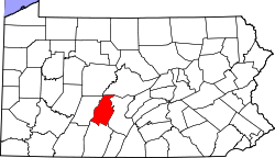
Fostoria is an unincorporated community and census-designated place (CDP) in Blair County, Pennsylvania, United States. It was first listed as a CDP prior to the 2020 census. [2]

The CDP is in northern Blair County, in the eastern part of Antis Township. It is bordered to the east by the Little Juniata River and to the west by the Pittsburgh Line of the Norfolk Southern Railway. Fostoria is 1.5 miles (2.4 km) north of Bellwood and 6 miles (10 km) southwest of Tyrone.

Demographics

Historical population
CensusPop.Note
2020 36
U.S. Decennial Census [4]

Related Research Articles

Frankstown is an unincorporated community and census-designated place (CDP) in Blair County, Pennsylvania, United States. It was first listed as a CDP prior to the 2020 census.

Beavertown is an unincorporated community and census-designated place (CDP) in Blair County, Pennsylvania, United States. It was first listed as a CDP prior to the 2020 census.

Blue Knob is an unincorporated community and census-designated place (CDP) in Blair County, Pennsylvania, United States. It was first listed as a CDP prior to the 2020 census.

Brooks Mill is an unincorporated community and census-designated place (CDP) in Blair County, Pennsylvania, United States. It was first listed as a CDP prior to the 2020 census.

Carson Valley is an unincorporated community and census-designated place (CDP) in Blair County, Pennsylvania, United States. It was first listed as a CDP prior to the 2020 census.

Cross Keys is an unincorporated community and census-designated place (CDP) in Blair County, Pennsylvania, United States. It was first listed as a CDP prior to the 2020 census.

Dumb Hundred is an unincorporated community and census-designated place (CDP) in Blair County, Pennsylvania, United States. It was first listed as a CDP prior to the 2020 census.

East Altoona is an unincorporated community and census-designated place (CDP) in Blair County, Pennsylvania, United States. It was first listed as a CDP prior to the 2020 census.

Franklin Forge is a census-designated place (CDP) in Blair County, Pennsylvania, United States. It was first listed as a CDP prior to the 2020 census.

Fredericksburg, also known as Clover Creek, is an unincorporated community and census-designated place (CDP) in Blair County, Pennsylvania, United States. It was first listed as a CDP prior to the 2020 census.

<span class="mw-page-title-main">Geeseytown, Pennsylvania</span> Census-designated place in Pennsylvania, United States

Geeseytown is an unincorporated community and census-designated place (CDP) in Blair County, Pennsylvania, United States. It was first listed as a CDP prior to the 2020 census.

Henrietta is an unincorporated community and census-designated place (CDP) in Blair County, Pennsylvania, United States. It was first listed as a CDP prior to the 2020 census.

Jugtown is an unincorporated community and census-designated place (CDP) in Blair County, Pennsylvania, United States. It was first listed as a CDP prior to the 2020 census.

Klahr is an unincorporated community and census-designated place (CDP) in Blair County, Pennsylvania, United States. It was first listed as a CDP prior to the 2020 census.

Leamersville is an unincorporated community and census-designated place (CDP) in Blair County, Pennsylvania, United States. It was first listed as a CDP prior to the 2020 census.

Mill Run is an unincorporated community and census-designated place (CDP) in Blair County, Pennsylvania, United States. It was first listed as a CDP prior to the 2020 census.

Millerstown is an unincorporated community and census-designated place (CDP) in Blair County, Pennsylvania, United States. It was first listed as a CDP prior to the 2020 census.

Nealmont is an unincorporated community and census-designated place (CDP) in Blair County, Pennsylvania, United States. It was first listed as a CDP prior to the 2020 census.

Oreminea is an unincorporated community and census-designated place (CDP) in Blair County, Pennsylvania, United States. It was first listed as a CDP prior to the 2020 census.

Penn Farms is an unincorporated community and census-designated place (CDP) in Blair County, Pennsylvania, United States. It was first listed as a CDP prior to the 2020 census.

References

  1. "ArcGIS REST Services Directory". United States Census Bureau. Retrieved October 12, 2022.
  2. 1 2 3 U.S. Geological Survey Geographic Names Information System: Fostoria, Pennsylvania
  3. "Census Population API". United States Census Bureau. Retrieved October 12, 2022.
  4. "Census of Population and Housing". Census.gov. Retrieved June 4, 2016.