Greenwood, Pennsylvania

Last updated

Greenwood, Pennsylvania
USA Pennsylvania location map.svg
Red pog.svg
Greenwood
Usa edcp location map.svg
Red pog.svg
Greenwood
Coordinates: 40°32′14″N78°21′16″W / 40.53722°N 78.35444°W / 40.53722; -78.35444
Country United States
State Pennsylvania
County Blair
Township Logan
Area
[1]
  Total1.64 sq mi (4.25 km2)
  Land1.64 sq mi (4.25 km2)
  Water0.00 sq mi (0.00 km2)
Elevation
[2]
1,188 ft (362 m)
Population
 (2020) [3]
  Total3,114
  Density1,898.78/sq mi (733.06/km2)
Time zone UTC-5 (Eastern (EST))
  Summer (DST) UTC-4 (EDT)
FIPS code 42-31368
GNIS feature ID2630602 [2]

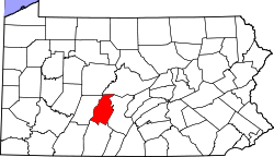
Greenwood is a census-designated place [4] in Logan Township, Blair County, Pennsylvania, United States. It is located near I-99 and is adjacent in the northeast to the city of Altoona. As of the 2010 census, the population was 2,458 residents. [5]

Contents

Demographics

Historical population
CensusPop.Note
2020 3,114
U.S. Decennial Census [6]

Related Research Articles

<span class="mw-page-title-main">Antis Township, Blair County, Pennsylvania</span> Township in Pennsylvania, United States

Antis Township is a township in Blair County, Pennsylvania, United States. The population was 6,484 at the 2020 census.

<span class="mw-page-title-main">Eyers Grove, Pennsylvania</span> Census-designated place in Pennsylvania, United States

Eyers Grove is a census-designated place in Columbia County, Pennsylvania, United States. It is part of Northeastern Pennsylvania. The population was 102 at the 2020 census. It is part of the Bloomsburg-Berwick micropolitan area.

<span class="mw-page-title-main">Greenwood Township, Columbia County, Pennsylvania</span> Township in Pennsylvania, United States

Greenwood Township is a township in Columbia County, Pennsylvania. It is part of Northeastern Pennsylvania. The population was 1,888 at the 2020 census.

<span class="mw-page-title-main">Iola, Pennsylvania</span> Census-designated place in Pennsylvania, United States

Iola is a census-designated place in Columbia County, Pennsylvania, United States. It is part of Northeastern Pennsylvania. The population was 154 at the 2020 census. It is part of the Bloomsburg-Berwick micropolitan area.

<span class="mw-page-title-main">Millville, Pennsylvania</span> Borough in Pennsylvania, United States

Millville is a borough in Columbia County, Pennsylvania, United States. It is part of Northeastern Pennsylvania. As of the 2020 census it had a population of 976. It is part of the Bloomsburg-Berwick micropolitan area.

<span class="mw-page-title-main">Geneva, Pennsylvania</span> Census-designated place in Pennsylvania, United States

Geneva is a census-designated place in Crawford County, Pennsylvania, United States. The population was 109 at the 2010 census.

<span class="mw-page-title-main">Petersburg, Pennsylvania</span> Borough in Pennsylvania, United States

Petersburg is a borough in Huntingdon County, Pennsylvania, United States. It was a stop on the former Pennsylvania Railroad Main Line between Tyrone and Huntingdon and the junction point for the Petersburg Branch. The population was 480 at the 2010 census.

<span class="mw-page-title-main">Armagh, Pennsylvania</span> Borough in Pennsylvania, United States

Armagh is a borough in Indiana County in the U.S. state of Pennsylvania. The population was 103 at the 2020 census.

<span class="mw-page-title-main">Greenwood Township, Juniata County, Pennsylvania</span> Township in Pennsylvania, United States

Greenwood Township is a township in Juniata County, Pennsylvania, United States. The population was 533 at the 2020 census, an increase over the figure of 617 tabulated in 2010.

<span class="mw-page-title-main">Blakely, Pennsylvania</span> Borough in Pennsylvania, United States

Blakely is a borough in Lackawanna County, Pennsylvania, United States. It is part of Northeastern Pennsylvania. The population was 6,657 at the 2020 census.

<span class="mw-page-title-main">Liverpool, Pennsylvania</span> Borough in Pennsylvania, United States

Liverpool is a borough located in the northeastern corner of Perry County, Pennsylvania, United States. It is part of the Harrisburg–Carlisle metropolitan statistical area.

<span class="mw-page-title-main">Liverpool Township, Perry County, Pennsylvania</span> Township in Pennsylvania, United States

Liverpool Township is a township in Perry County, Pennsylvania, United States. The population was 1,037 at the 2020 census. It is not to be confused with the borough of Liverpool, which is adjacent.

<span class="mw-page-title-main">Great Bend, Pennsylvania</span> Borough in Pennsylvania, United States

Great Bend is a borough in Susquehanna County, Pennsylvania, United States, 39 miles (63 km) north of Scranton. According to 2020 Census data, Great Bend's population was 634, down 13.6% from 2010. Great Bend sits along the Susquehanna River, less than two miles from the New York State border, and is located directly off Interstate 81. Several small manufacturers also call Great Bend home. Great Bend is considered a bedroom community of the Binghamton, NY metropolitan area. Downtown Binghamton is roughly 11 miles (18 km) from Great Bend. The borough has three public parks. Billy Greenwood Memorial Park on Kilrow Avenue and Veterans' Memorial Park on Spring St. overlook the Susquehanna River. Great Bend is within the Blue Ridge School District.

Baumstown is a census-designated place in Exeter Township, Berks County, Pennsylvania, United States, located near the borough of Birdsboro. It is located at the junction of U.S. Highway 422 and Pennsylvania Route 345. As of the 2020 census the population of Baumstown was 346 residents.

Mohrsville is a census-designated place in Centre Township, Berks County, Pennsylvania, United States. It is located approximately three miles south of the borough of Shoemakersville, along the Schuylkill River. As of the 2010 census, the population was 383 residents.

Colony Park is a census-designated place in Spring Township, Berks County, Pennsylvania, United States. It is located just off U.S. 222, approximately one mile northwest of the borough of Wyomissing. As of the 2020 census, the population was 1,269 residents.

Grazierville is a census-designated place in Snyder Township, Blair County, Pennsylvania, United States. It is located near I-99 and is approximately one mile to the south of the borough of Tyrone. As of the 2010 census, the population was 665 residents.

Greens Landing is a census-designated place in Athens Township, Bradford County, Pennsylvania, United States. It is part of Northeastern Pennsylvania and is located along US Route 220 approximately five miles south of the borough of Athens. As of the 2010 census, the population of Greens Landing was 894 residents.

<span class="mw-page-title-main">Kerrtown, Pennsylvania</span> Census-designated place in Pennsylvania, United States

Kerrtown is a census-designated place located in Vernon Township, Crawford County, Pennsylvania, United States, at the intersection of U.S. Routes 6/19/322 and Pennsylvania Route 102, just west of the city of Meadville. At the 2010 census, the population was 305.

<span class="mw-page-title-main">Haverford College, Pennsylvania</span> Census-designated place in Pennsylvania, United States

Haverford College (CDP) is a census-designated place located in Haverford Township, Delaware County, and Lower Merion Township, Montgomery County, in the U.S. state of Pennsylvania. It corresponds to the campus of Haverford College, located on the southwestern side of U.S. Route 30, approximately 10 miles (16 km) northwest of the city of Philadelphia. As of the 2010 census, the population was 1,331.

References

  1. "ArcGIS REST Services Directory". United States Census Bureau. Retrieved October 12, 2022.
  2. 1 2 U.S. Geological Survey Geographic Names Information System: Greenwood, Pennsylvania
  3. "Census Population API". United States Census Bureau. Retrieved October 12, 2022.
  4. "2010 U.S. Census website". United States Census Bureau . Retrieved February 10, 2013.
  5. "U.S. Census website". United States Census Bureau . Retrieved May 14, 2011.
  6. "Census of Population and Housing". Census.gov. Retrieved June 4, 2016.