Logan Township, Blair County, Pennsylvania

Last updated

Logan Township,
Blair County,
Pennsylvania
Horseshoe Curve Penna2.jpg
Three trains passing on triple-track mainline of Norfolk Southern Railway at Horseshoe Curve in Logan Township
Map of Logan Township, Blair County, Pennsylvania Highlighted.png
Map of Blair County, Pennsylvania highlighting Logan Township
USA Pennsylvania location map.svg
Red pog.svg
Logan Township
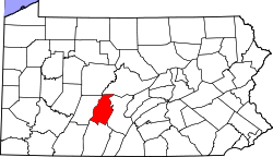
Location of Logan Township in Pennsylvania
Coordinates: 40°31′30″N78°30′29″W / 40.52500°N 78.50806°W / 40.52500; -78.50806
Country United States
State Pennsylvania
County Blair
Settled1770
Incorporated1850
Government
  TypeBoard of Supervisors
Area
[1]
  Total46.84 sq mi (121.31 km2)
  Land46.51 sq mi (120.46 km2)
  Water0.33 sq mi (0.85 km2)
Population
 (2020) [2]
  Total12,404 Decrease2.svg
  Density270.06/sq mi (104.27/km2)
Time zone UTC-5 (Eastern (EST))
  Summer (DST) UTC-4 (EDT)
Area code 814
FIPS code 42-013-44328
Website www.logantownship-pa.gov

Logan Township is a township in Blair County, Pennsylvania, United States. It is part of the Altoona, PA Metropolitan Statistical Area. It is the most populous township in Blair County, with a population of 12,413 at the 2020 census. Logan Township is home to Horseshoe Curve, a National Historic Landmark. [3]

Contents

General information

Geography

Logan Township is located in west-central Blair County and nearly encloses the city of Altoona. The Interstate 99/U.S. Route 220 freeway passes through Logan Township as it bypasses Altoona to the east, with access from Exits 31, 32, and 33. The township includes the unincorporated communities of Wopsononock, Juniata Gap, East Altoona, Greenwood, Red Hill, Newburg, Mill Run, Eldorado, and Lakemont.

Horseshoe Curve is located in the southwestern part of the township where the Norfolk Southern Railway's Pittsburgh Line climbs the Allegheny Front, a major escarpment at the edge of the Allegheny Mountains of central Pennsylvania.

According to the United States Census Bureau, the township has a total area of 46.7 square miles (121.0 km2), of which 46.4 square miles (120.1 km2) is land and 0.31 square miles (0.8 km2), or 0.70%, is water.

Demographics

Historical population
CensusPop.Note
2000 11,925
2010 12,2893.1%
2020 12,4040.9%
U.S. Decennial Census [4]

As of the census [5] of 2010, there were 12,289 people, 4,875 households, and 3,111 families residing in the township. The population density was 262.4 inhabitants per square mile (101.3/km2). There were 5,111 housing units at an average density of 109.1 per square mile (42.1/km2). The racial makeup of the township was 96.6% White, 1.2% African American, 0.1% Native American, 0.9% Asian, 0.02% Pacific Islander, 0.2% from other races, and 0.8% from two or more races. Hispanic or Latino of any race were 0.9% of the population.

There were 4,875 households, out of which 36.4% had children under the age of 18 living with them, 63.8% were married couples living together, 9.1% had a female householder with no husband present, and 36.2% were non-families. 25.4% of all households were made up of individuals, and 16.4% had someone living alone who was 65 years of age or older. The average household size was 2.42 and the average family size was 2.8.

In the township the population was spread out, with 16.3% under the age of 18, 18.5% from 18 to 24, 19.0% from 25 to 44, 29.7% from 45 to 64, and 16.4% who were 65 years of age or older. The median age was 41.5 years. For every 100 females, there were 96.8 males. For every 100 females age 18 and over, there were 95.6 males.

The median income for a household in the township was $36,993, and the median income for a family was $48,943. Males had a median income of $45,988 versus $32,051 for females. The per capita income for the township was $26,033. About 6.6% of families and 14.1% of the population were below the poverty line, including 14.9% of those under age 18 and 7.5% of those age 65 or over.

Related Research Articles

<span class="mw-page-title-main">Blair County, Pennsylvania</span> County in Pennsylvania, United States

Blair County is a county in the Commonwealth of Pennsylvania. As of the 2020 census, the population was 122,822. Its county seat is Hollidaysburg, and its largest city is Altoona. The county was created on February 26, 1846, from parts of Huntingdon and Bedford counties. The county is part of the Southwest Pennsylvania region of the state.

<span class="mw-page-title-main">Allegheny Township, Blair County, Pennsylvania</span> Township in Pennsylvania, United States

Allegheny Township is a township in Blair County, Pennsylvania, United States. The population was 6,585 at the 2020 census. It is part of the Altoona, Pennsylvania Metropolitan Statistical Area.

<span class="mw-page-title-main">Altoona, Pennsylvania</span> City in Pennsylvania, United States

Altoona is a city in Blair County, Pennsylvania, United States. The population was 43,963 at the time of the 2020 census. It is the principal city of the Altoona metropolitan area, which includes all of Blair County and was recorded as having a population of 122,822 in 2020.

<span class="mw-page-title-main">Bellwood, Pennsylvania</span> Borough in Pennsylvania, United States

Bellwood is a borough in Blair County, Pennsylvania, United States. It is part of the Altoona, PA Metropolitan Statistical Area. The population was at 1,829 as of the 2020 census.

<span class="mw-page-title-main">Blair Township, Pennsylvania</span> Township in Pennsylvania, United States

Blair Township is a township in Blair County, Pennsylvania, United States. The population was 4,785 at the 2020 census.

<span class="mw-page-title-main">Catharine Township, Pennsylvania</span> Township in Pennsylvania, United States

Catharine Township is a township in Blair County, Pennsylvania, United States. The population was 773 at the 2020 census. It is part of the Altoona, PA Metropolitan Statistical Area.

<span class="mw-page-title-main">Frankstown Township, Blair County, Pennsylvania</span> Township in Pennsylvania, United States

Frankstown Township is a township in Blair County, Pennsylvania, United States. It is part of the Altoona Metropolitan Statistical Area. The population was 7,399 at the 2020 census. The township was named after Stephen Franks, a pioneer citizen.

<span class="mw-page-title-main">Freedom Township, Blair County, Pennsylvania</span> Township in Pennsylvania, United States

Freedom Township is a township in Blair County, Pennsylvania, United States. It is part of the Altoona, PA Metropolitan Statistical Area. The population was 3,005 at the 2020 census.

<span class="mw-page-title-main">Greenfield Township, Blair County, Pennsylvania</span> Township in Pennsylvania, United States

Greenfield Township is a township in Blair County, Pennsylvania, United States. It is part of the Altoona, PA Metropolitan Statistical Area. The population was 3,785 at the 2020 census.

<span class="mw-page-title-main">Huston Township, Blair County, Pennsylvania</span> Township in Pennsylvania, United States

Huston Township is a township in Blair County, Pennsylvania, United States. It is part of the Altoona, PA Metropolitan Statistical Area. The population was 1,247 at the 2020 census.

<span class="mw-page-title-main">Juniata Township, Blair County, Pennsylvania</span> Township in Pennsylvania, United States

Juniata Township is a township in Blair County, Pennsylvania, United States. It is part of the Altoona, PA Metropolitan Statistical Area. The population was 965 at the 2020 census.

<span class="mw-page-title-main">North Woodbury Township, Pennsylvania</span> Township in Pennsylvania, United States

North Woodbury Township is a township in Blair County, Pennsylvania, United States. It is part of the Altoona, PA Metropolitan Statistical Area. The population was 2,434 at the 2020 census.

<span class="mw-page-title-main">Snyder Township, Blair County, Pennsylvania</span> Township in Pennsylvania, United States

Snyder Township is a township in Blair County, Pennsylvania, United States. It is part of the Altoona, PA Metropolitan Statistical Area. The population was 3,345 at the 2020 census.

<span class="mw-page-title-main">Taylor Township, Blair County, Pennsylvania</span> Township in Pennsylvania, United States

Taylor Township is a township in Blair County, Pennsylvania, United States. It is part of the Altoona, PA Metropolitan Statistical Area. The population was 2,296 at the 2020 census.

<span class="mw-page-title-main">Tyrone Township, Blair County, Pennsylvania</span> Township in Pennsylvania, United States

Tyrone Township is a township in Blair County, Pennsylvania, United States. It is part of the Altoona, PA Metropolitan Statistical Area. The population was 1,873 at the 2020 census.

<span class="mw-page-title-main">Dean Township, Cambria County, Pennsylvania</span> Township in Pennsylvania, United States

Dean Township is a township in Cambria County, Pennsylvania, United States. The population was 391 at the 2010 census. It is part of the Johnstown, Pennsylvania Metropolitan Statistical Area despite being much closer to Altoona.

<span class="mw-page-title-main">Gallitzin, Pennsylvania</span> Borough in Pennsylvania, United States

Gallitzin is a borough in Cambria County, Pennsylvania, United States. It is bordered by Gallitzin Township and Tunnelhill, all of which sit astride the Eastern continental divide. Tunnel Hill and Gallitzin both are pierced by railroad tunnels shortening the necessary ascent for rails crossing the Allegheny Front onto the Allegheny Plateau which encompasses the towns' terrains. Topping the gaps of the Allegheny, the area is one of only five major breaks in the Appalachians allowing east–west transportation corridors before the advent of 20th century technologies.

<span class="mw-page-title-main">Gallitzin Township, Cambria County, Pennsylvania</span> Township in Pennsylvania, United States

Gallitzin Township is a township in Cambria County, Pennsylvania, United States. The township nearly surrounds, but is a separate entity from, Gallitzin borough. As of the 2010 census, the township population was 1,324. It is part of the Johnstown, Pennsylvania Metropolitan Statistical Area.

<span class="mw-page-title-main">Portage Township, Cambria County, Pennsylvania</span> Township in Pennsylvania, United States

Portage Township is a township in Cambria County, Pennsylvania, United States. It surrounds the borough of Portage. The township population was 3,640 at the 2010 census. It is part of the Johnstown, Pennsylvania Metropolitan Statistical Area.

<span class="mw-page-title-main">Shenango Township, Mercer County, Pennsylvania</span> Township in Pennsylvania, United States

Shenango Township is a township in Mercer County, Pennsylvania, United States. The population was 3,519 at the 2020 census, down from 3,929 in 2010.

References

  1. "2016 U.S. Gazetteer Files". United States Census Bureau. Retrieved August 13, 2017.
  2. "City and Town Population Totals: 2020-2022". Census.gov. US Census Bureau. Retrieved March 5, 2024.
  3. 2007 General Highway Map Blair County Pennsylvania (PDF) (Map). 1:65,000. Pennsylvania Department of Transportation, Bureau of Planning and Research, Geographic Information Division. Retrieved April 2, 2008.[ permanent dead link ]Note: shows Horseshoe Curve
  4. "United States Census Bureau QuickFacts". United States Census Bureau. Retrieved February 26, 2022.
  5. "U.S. Census website". United States Census Bureau . Retrieved December 15, 2018.

40°31′30″N78°30′29″W / 40.52500°N 78.50806°W / 40.52500; -78.50806