Geeseytown, Pennsylvania | |
|---|---|
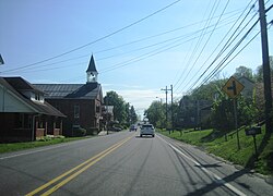 Westbound US 22 in Geeseytown | |
 Geeseytown  Geeseytown | |
| Coordinates: 40°27′06″N78°20′38″W / 40.45167°N 78.34389°W | |
| Country | United States |
| State | Pennsylvania |
| County | Blair |
| Township | Frankstown |
| Area | |
• Total | 0.16 sq mi (0.42 km2) |
| • Land | 0.16 sq mi (0.42 km2) |
| • Water | 0 sq mi (0.00 km2) |
| Elevation | 991 ft (302 m) |
| Population | |
• Total | 107 |
| • Density | 663.5/sq mi (256.19/km2) |
| Time zone | UTC-5 (Eastern (EST)) |
| • Summer (DST) | UTC-4 (EDT) |
| ZIP Code | 16648 (Hollidaysburg) |
| Area codes | 814/582 |
| FIPS code | 42-28696 |
| GNIS feature ID | 2805506 [2] |
Geeseytown is an unincorporated community and census-designated place (CDP) in Blair County, Pennsylvania, United States. It was first listed as a CDP prior to the 2020 census. [2]
Contents
The CDP is in central Blair County, in the western part of Frankstown Township. U.S. Route 22 passes through the community, leading southwest 3 miles (5 km) to Hollidaysburg and northeast 4 miles (6 km) to Canoe Creek. Geeseytown is on the north side of the valley of the Frankstown Branch Juniata River, one of the main headwater branches of the Juniata River which leads east to the Susquehanna.
