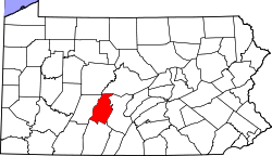
Canoe Creek, Pennsylvania

Last updated

Canoe Creek, Pennsylvania
USA Pennsylvania location map.svg
Red pog.svg
Canoe Creek
Location within the state of Pennsylvania
Usa edcp location map.svg
Red pog.svg
Canoe Creek
Canoe Creek (the United States)
Coordinates: 40°28′25″N78°16′44″W / 40.47361°N 78.27889°W / 40.47361; -78.27889
Country United States
State Pennsylvania
County Blair
Township Frankstown
Area
[1]
  Total0.12 sq mi (0.32 km2)
  Land0.12 sq mi (0.32 km2)
  Water0.00 sq mi (0.00 km2)
Elevation
[2]
906 ft (276 m)
Population
 (2020) [3]
  Total66
  Density540.98/sq mi (209.26/km2)
Time zone UTC-5 (Eastern (EST))
  Summer (DST) UTC-4 (EDT)
Area code 814
FIPS code 42-11136
GNIS feature ID2805471 [2]

Canoe Creek is an unincorporated community and census-designated place (CDP) in Frankstown Township, Blair County, Pennsylvania, United States. It is located on U.S. Route 22. It was first listed as a CDP prior to the 2020 census. [2]

Demographics

Historical population
CensusPop.Note
2020 66
U.S. Decennial Census [4] [3]

Related Research Articles

<span class="mw-page-title-main">Brickerville, Pennsylvania</span> Census-designated place in Pennsylvania, United States

Brickerville is an unincorporated community and census-designated place (CDP) in Elizabeth Township, Lancaster County, Pennsylvania, United States, with a ZIP code of 17543. The population was 1,309 at the 2010 census.

<span class="mw-page-title-main">Beurys Lake, Pennsylvania</span> CDP in Pennsylvania, United States

Beurys Lake is a census-designated place in Schuylkill County, Pennsylvania, United States. The population was 133 at the 2000 census.

Leola is a census-designated place (CDP) in Lancaster County, Pennsylvania, United States. It includes the unincorporated communities of Leola, Leacock, and Bareville, and prior to 2010 was known as the Leacock-Leola-Bareville census-designated place. Originally named "Mechanicsburg", its present name is a portmanteau of "Leacock" and the "Glenola" train station that once served the town. As of the 2010 census, the population of the CDP was 7,214.

Landisville is an unincorporated community and census-designated place (CDP) in East Hempfield Township, Lancaster County, Pennsylvania, United States. As of the 2010 census the population was 1,893. The community was once part of the Salunga-Landisville CDP, before splitting into two separate CDPs for the 2010 census, the other being Salunga.

East Earl is an unincorporated community and census-designated place (CDP) in East Earl Township, Lancaster County, Pennsylvania, United States. As of the 2010 census, it had a population of 1,144.

<span class="mw-page-title-main">New Tripoli, Pennsylvania</span> Census-designated place in Pennsylvania, United States

New Tripoli is an unincorporated community and census-designated place (CDP) in Lynn Township in Lehigh County, Pennsylvania. As of the 2020 census, the population was 840. New Tripoli is part of the Lehigh Valley, which had a population of 861,899 and was the 68th-most populous metropolitan area in the U.S. as of the 2020 census.

Hopeland is a small unincorporated hamlet and census-designated place (CDP) that is located in Lancaster County in the south of the U.S. state of Pennsylvania in the United States. The hamlet's ZIP code is 17533.

<span class="mw-page-title-main">Kirkwood, Pennsylvania</span> Census-designated place in Pennsylvania, United States

Kirkwood is an unincorporated farming town and census-designated place (CDP) in Colerain Township, Lancaster County, Pennsylvania, United States. It is part of the Lancaster Metro area, in Pennsylvania Dutch Country. The ZIP code is 17536. As of the 2010 census, the population was 396.

<span class="mw-page-title-main">Cetronia, Pennsylvania</span> Census-designated place in Pennsylvania, United States

Cetronia is a census-designated place (CDP) in South Whitehall Township in Lehigh County, Pennsylvania, located near Allentown. As of the 2020 census, its population was 2,421.

<span class="mw-page-title-main">Falmouth, Pennsylvania</span> Census-designated place in Pennsylvania, United States

Falmouth is an unincorporated community and census-designated place (CDP) in Conoy Township, Lancaster County, Pennsylvania, United States. As of the 2010 census the population was 420, but the 2020 census shows that the population has decreased to 397.

Fivepointville is an unincorporated community and census-designated place (CDP) in Brecknock Township, Lancaster County, Pennsylvania, United States. As of the 2010 census, the population was 1,156. The town is named for its position at an intersection of five separate roads.

Kenmar is a census-designated place (CDP) in Loyalsock Township, Lycoming County, Pennsylvania, United States. As of the 2010 census, it had a population of 4,124. Kenmar is not a separately incorporated community, but is a part of Loyalsock Township.

Pikes Creek is a census-designated place (CDP) in Lake Township, Luzerne County, Pennsylvania, United States. The population was 269 at the 2010 census.

<span class="mw-page-title-main">Clay, Pennsylvania</span> Census-designated place in Pennsylvania, United States

Clay is an unincorporated community and census-designated place (CDP) in Clay Township, Lancaster County, Pennsylvania, United States. It is located along U.S. Route 322 between Brickerville and Ephrata. As of the 2010 census, the population was 1,559.

Little Britain is an unincorporated community and census-designated place (CDP) in Little Britain Township, Lancaster County, Pennsylvania, United States. At the 2010 census, the population was 372.

Hebron is a census-designated place in South Lebanon Township, Lebanon County, Pennsylvania, United States. As of the 2010 census the population was 1,305. The Lebanon County Prison is located within the CDP.

Fisherville is an unincorporated community and census-designated place (CDP) in Blair County, Pennsylvania, United States. It was first listed as a CDP prior to the 2020 census.

<span class="mw-page-title-main">Geeseytown, Pennsylvania</span> Census-designated place in Pennsylvania, United States

Geeseytown is an unincorporated community and census-designated place (CDP) in Blair County, Pennsylvania, United States. It was first listed as a CDP prior to the 2020 census.

Linds Crossing is a census-designated place (CDP) in Blair County, Pennsylvania, United States. Comprising the unincorporated communities of Linds Crossing and Upper Reese, it was first listed as a CDP prior to the 2020 census.

Moores Mill is a census-designated place (CDP) in Blair County, Pennsylvania, United States. It was first listed as a CDP prior to the 2020 census.

References

  1. "ArcGIS REST Services Directory". United States Census Bureau. Retrieved October 12, 2022.
  2. 1 2 3 U.S. Geological Survey Geographic Names Information System: Canoe Creek, Pennsylvania
  3. 1 2 "Census Population API". United States Census Bureau. Retrieved October 12, 2022.
  4. "Census of Population and Housing". Census.gov. Retrieved June 4, 2016.