Grazierville, Pennsylvania

Last updated

Grazierville, Pennsylvania
USA Pennsylvania location map.svg
Red pog.svg
Grazierville
Usa edcp location map.svg
Red pog.svg
Grazierville
Coordinates: 40°39′27″N78°16′17″W / 40.65750°N 78.27139°W / 40.65750; -78.27139
Country United States
State Pennsylvania
County Blair
Township Snyder
Area
[1]
  Total
1.07 sq mi (2.78 km2)
  Land1.07 sq mi (2.78 km2)
  Water0.00 sq mi (0.00 km2)
Elevation
[2]
994 ft (303 m)
Population
 (2020) [3]
  Total
670
  Density624.42/sq mi (241.13/km2)
Time zone UTC-5 (Eastern (EST))
  Summer (DST) UTC-4 (EDT)
ZIP code
16686 [4]
Area code 814
FIPS code 42-30704
GNIS feature ID2630012 [2]

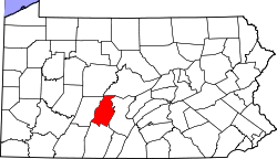
Grazierville is a census-designated place [5] in Snyder Township, Blair County, Pennsylvania, United States. It is located near I-99 and is approximately one mile to the south of the borough of Tyrone. As of the 2010 census, the population was 665 residents. [6]

Contents

Demographics

Historical population
CensusPop.Note
2020 670
U.S. Decennial Census [7]

Education

The school district is the Tyrone Area School District. [8]

References

  1. "ArcGIS REST Services Directory". United States Census Bureau. Retrieved October 12, 2022.
  2. 1 2 U.S. Geological Survey Geographic Names Information System: Grazierville, Pennsylvania
  3. "Census Population API". United States Census Bureau. Retrieved October 12, 2022.
  4. "Grazierville PA ZIP Code". zipdatamaps.com. 2023. Retrieved June 27, 2023.
  5. "2010 U.S. Census website". United States Census Bureau . Retrieved February 10, 2013.
  6. "U.S. Census website". United States Census Bureau . Retrieved May 14, 2011.
  7. "Census of Population and Housing". Census.gov. Retrieved June 4, 2016.
  8. "2020 CENSUS - SCHOOL DISTRICT REFERENCE MAP: Blair County, PA" (PDF). U.S. Census Bureau . Retrieved December 22, 2024. - Text list