Charlottsville, Pennsylvania | |
---|---|
Coordinates: 40°38′44″N78°16′32″W / 40.64556°N 78.27556°W | |
Country | United States |
State | Pennsylvania |
County | Blair |
Townships | Antis, Snyder |
Area | |
• Total | 0.07 sq mi (0.19 km2) |
• Land | 0.07 sq mi (0.19 km2) |
• Water | 0.00 sq mi (0.00 km2) |
Elevation | 932 ft (284 m) |
Population | |
• Total | 48 |
• Density | 666.67/sq mi (257.07/km2) |
Time zone | UTC-5 (Eastern (EST)) |
• Summer (DST) | UTC-4 (EDT) |
ZIP Code | 16686 (Tyrone) |
Area code(s) | 814/582 |
FIPS code | 42-12768 |
GNIS feature ID | 2805474 [2] |
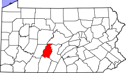
Charlottsville is an unincorporated community and census-designated place (CDP) in Blair County, Pennsylvania, United States. It was first listed as a CDP prior to the 2020 census. [2]
The CDP is in northern Blair County, mostly in the eastern part of Antis Township but extending northeastward into the southern part of Snyder Township. North Pleasant Valley Boulevard (old U.S. Route 220) forms the southeastern edge of the CDP, and the Pittsburgh Line of the Norfolk Southern Railway forms the northwestern edge. Interstate 99 passes southeast of the community, with access from Exit 45 at Pleasant Valley Boulevard. Tyrone is 3 miles (5 km) to the northeast, and Altoona is 11 miles (18 km) to the southwest.
Charlottsville is on the northwestern side of the valley of the Little Juniata River, which flows east to join the Juniata River near Petersburg.
Census | Pop. | Note | %± |
---|---|---|---|
2020 | 48 | — | |
U.S. Decennial Census [4] [3] |
East Sharpsburg is an unincorporated community and census-designated place (CDP) in Blair County, Pennsylvania, United States. It was first listed as a CDP prior to the 2020 census.
Brooks Mill is an unincorporated community and census-designated place (CDP) in Blair County, Pennsylvania, United States. It was first listed as a CDP prior to the 2020 census.
Canan Station is an unincorporated community and census-designated place (CDP) in Blair County, Pennsylvania, United States. It was first listed as a CDP prior to the 2020 census. The community is also known as Canan.
Clappertown is an unincorporated community and census-designated place (CDP) in Blair County, Pennsylvania, United States. It was first listed as a CDP prior to the 2020 census.
Cotton Town is an unincorporated community and census-designated place (CDP) in Blair County, Pennsylvania, United States. It was first listed as a CDP prior to the 2020 census.
Cross Keys is an unincorporated community and census-designated place (CDP) in Blair County, Pennsylvania, United States. It was first listed as a CDP prior to the 2020 census.
East Altoona is an unincorporated community and census-designated place (CDP) in Blair County, Pennsylvania, United States. It was first listed as a CDP prior to the 2020 census.
Elberta is an unincorporated community and census-designated place (CDP) in Blair County, Pennsylvania, United States. It was first listed as a CDP prior to the 2020 census.
Fort Fetters is a neighborhood and census-designated place (CDP) in Blair County, Pennsylvania, United States. It was first listed as a CDP prior to the 2020 census.
Franklin Forge is a census-designated place (CDP) in Blair County, Pennsylvania, United States. It was first listed as a CDP prior to the 2020 census.
Fredericksburg, also known as Clover Creek, is an unincorporated community and census-designated place (CDP) in Blair County, Pennsylvania, United States. It was first listed as a CDP prior to the 2020 census.
Ganister is an unincorporated community and census-designated place (CDP) in Blair County, Pennsylvania, United States. It was first listed as a CDP prior to the 2020 census.
Geeseytown is an unincorporated community and census-designated place (CDP) in Blair County, Pennsylvania, United States. It was first listed as a CDP prior to the 2020 census.
Gray is an unincorporated community and census-designated place (CDP) in Blair County, Pennsylvania, United States. It was first listed as a CDP prior to the 2020 census.
Klahr is an unincorporated community and census-designated place (CDP) in Blair County, Pennsylvania, United States. It was first listed as a CDP prior to the 2020 census.
Leamersville is an unincorporated community and census-designated place (CDP) in Blair County, Pennsylvania, United States. It was first listed as a CDP prior to the 2020 census.
Olivia is an unincorporated community and census-designated place (CDP) in Blair County, Pennsylvania, United States. It was first listed as a CDP prior to the 2020 census.
Pinecroft is an unincorporated community and census-designated place (CDP) in Blair County, Pennsylvania, United States. It was first listed as a CDP prior to the 2020 census.
Point View is an unincorporated community and census-designated place (CDP) in Blair County, Pennsylvania, United States. It was first listed as a CDP prior to the 2020 census.
Royer is an unincorporated community and census-designated place (CDP) in Blair County, Pennsylvania, United States. It was first listed as a CDP prior to the 2020 census.