Royer, Pennsylvania

Last updated

Royer, Pennsylvania
USA Pennsylvania location map.svg
Red pog.svg
Royer
Usa edcp location map.svg
Red pog.svg
Royer
Coordinates: 40°25′20″N78°16′20″W / 40.42222°N 78.27222°W / 40.42222; -78.27222
CountryUnited States
State Pennsylvania
County Blair
Township Woodbury
Area
[1]
  Total
0.13 sq mi (0.34 km2)
  Land0.13 sq mi (0.34 km2)
  Water0.0 sq mi (0.0 km2)
Elevation
[2]
1,083 ft (330 m)
Time zone UTC-5 (Eastern (EST))
  Summer (DST) UTC-4 (EDT)
ZIP Code
16693 (Williamsburg)
Area code(s) 814/582
FIPS code 42-66568
GNIS feature ID2805555 [2]

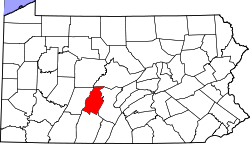
Royer is an unincorporated community and census-designated place (CDP) in Blair County, Pennsylvania, United States. It was first listed as a CDP prior to the 2020 census. [2]

The CDP is in eastern Blair County, in the southwestern corner of Woodbury Township. It sits in the valley of Piney Creek, a northward-flowing tributary of the Frankstown Branch Juniata River. Pennsylvania Route 866 runs along the eastern edge of the community, leading northeast 5 miles (8 km) to Williamsburg and south-southwest 8 miles (13 km) to Martinsburg.

The Daniel Royer House, listed on the National Register of Historic Places, is in the eastern part of the community.

Education

It is in the Williamsburg Community School District. [3]

Related Research Articles

Beavertown is an unincorporated community and census-designated place (CDP) in Blair County, Pennsylvania, United States. It was first listed as a CDP prior to the 2020 census.

Blue Knob is an unincorporated community and census-designated place (CDP) in Blair County, Pennsylvania, United States. It was first listed as a CDP prior to the 2020 census.

Carson Valley is an unincorporated community and census-designated place (CDP) in Blair County, Pennsylvania, United States. It was first listed as a CDP prior to the 2020 census.

Cove Forge is a census-designated place (CDP) in Blair County, Pennsylvania, United States. It includes the unincorporated community of Covedale. Cove Forge was first listed as a CDP prior to the 2020 census.

Cross Keys is an unincorporated community and census-designated place (CDP) in Blair County, Pennsylvania, United States. It was first listed as a CDP prior to the 2020 census.

Fisherville is an unincorporated community and census-designated place (CDP) in Blair County, Pennsylvania, United States. It was first listed as a CDP prior to the 2020 census.

Franklin Forge is a census-designated place (CDP) in Blair County, Pennsylvania, United States. It was first listed as a CDP prior to the 2020 census.

Ganister is an unincorporated community and census-designated place (CDP) in Blair County, Pennsylvania, United States. It was first listed as a CDP prior to the 2020 census.

Klahr is an unincorporated community and census-designated place (CDP) in Blair County, Pennsylvania, United States. It was first listed as a CDP prior to the 2020 census.

Larke is an unincorporated community and census-designated place (CDP) in Blair County, Pennsylvania, United States. It was first listed as a CDP prior to the 2020 census.

Moores Mill is a census-designated place (CDP) in Blair County, Pennsylvania, United States. It was first listed as a CDP prior to the 2020 census.

Oreminea is an unincorporated community and census-designated place (CDP) in Blair County, Pennsylvania, United States. It was first listed as a CDP prior to the 2020 census.

Point View is an unincorporated community and census-designated place (CDP) in Blair County, Pennsylvania, United States. It was first listed as a CDP prior to the 2020 census.

Reese is an unincorporated community and census-designated place (CDP) in Blair County, Pennsylvania, United States. It was first listed as a CDP prior to the 2020 census.

Reservoir is an unincorporated community and census-designated place (CDP) in Blair County, Pennsylvania, United States. It was first listed as a CDP prior to the 2020 census.

Robeson Extension is an unincorporated community and census-designated place (CDP) in Blair County, Pennsylvania, United States. It was first listed as a CDP prior to the 2020 census.

Shelltown is an unincorporated community and census-designated place (CDP) in Blair County, Pennsylvania, United States. It was first listed as a CDP prior to the 2020 census.

Shellytown is an unincorporated community and census-designated place (CDP) in Blair County, Pennsylvania, United States. It was first listed as a CDP prior to the 2020 census.

St. Clair is an unincorporated community and census-designated place (CDP) in Blair County, Pennsylvania, United States. It was first listed as a CDP prior to the 2020 census.

Vail is an unincorporated community and census-designated place (CDP) in Blair County, Pennsylvania, United States. It was first listed as a CDP prior to the 2020 census.

References

  1. "2020 U.S. Gazetteer Files – Pennsylvania". United States Census Bureau. Retrieved August 30, 2021.
  2. 1 2 3 U.S. Geological Survey Geographic Names Information System: Royer, Pennsylvania
  3. "2020 CENSUS - SCHOOL DISTRICT REFERENCE MAP: Blair County, PA" (PDF). U.S. Census Bureau . Retrieved January 2, 2025. - Text list