Newry, Pennsylvania

Last updated
Newry, Pennsylvania
Farmers Market Newry PA.jpg
Farmers market
Blair County Pennsylvania Incorporated and Unincorporated areas Newry Highlighted.svg
Location of Newry in Blair County, Pennsylvania.
USA Pennsylvania location map.svg
Red pog.svg
Newry
Coordinates: 40°23′36″N78°26′06″W / 40.39333°N 78.43500°W / 40.39333; -78.43500
Country United States
State Pennsylvania
County Blair
Settled1793
Incorporated1876
Government
  TypeBorough Council
Area
[1]
  Total0.10 sq mi (0.25 km2)
  Land0.10 sq mi (0.25 km2)
  Water0.00 sq mi (0.00 km2)
Elevation
[2]
1,050 ft (320 m)
Population
 (2020) [3]
  Total230
  Density2,346.94/sq mi (905.39/km2)
Time zone UTC-5 (Eastern (EST))
  Summer (DST) UTC-4 (EDT)
Zip code
16665
Area code 814
FIPS code 42-54024
GNIS feature ID1182411 [2]

Newry is a borough in Blair County, Pennsylvania, United States. The population was 231 at the 2020 census. [4] It is part of the Altoona, PA Metropolitan Statistical Area and one of the communities comprising the Altoona Urban Area.

Contents

It was named after the town of Newry in Northern Ireland.

Geography

Newry is located at 40°23′36″N78°26′6″W / 40.39333°N 78.43500°W / 40.39333; -78.43500 (40.393223, -78.435085). [5]

According to the United States Census Bureau, the borough has a total area of 0.1 square miles (0.26 km2), all land.

South of Newry, the stream known as Poplar Run flows to the east towards the Frankstown Branch of the Juniata River.

Demographics

Historical population
CensusPop.Note
1880 326
1890 3352.8%
1900 3504.5%
1910 3808.6%
1920 3974.5%
1930 394−0.8%
1940 4175.8%
1950 412−1.2%
1960 4324.9%
1970 4442.8%
1980 353−20.5%
1990 288−18.4%
2000 245−14.9%
2010 27010.2%
2020 231−14.4%
2021 (est.)235 [4] 1.7%
Sources: [6] [7] [8] [3]

As of the census [7] of 2000, there were 245 people, 107 households, and 61 families residing in the borough. The population density was 2,550.2 inhabitants per square mile (984.6/km2). There were 116 housing units at an average density of 1,207.4 per square mile (466.2/km2). The racial makeup of the borough was 97.14% White, 0.82% African American, 0.82% from other races, and 1.22% from two or more races. Hispanic or Latino of any race were 1.22% of the population.

There were 107 households, out of which 29.9% had children under the age of 18 living with them, 44.9% were married couples living together, 10.3% had a female householder with no husband present, and 42.1% were non-families. 38.3% of all households were made up of individuals, and 9.3% had someone living alone who was 65 years of age or older. The average household size was 2.26 and the average family size was 3.08.

In the borough the population was spread out, with 24.9% under the age of 18, 7.8% from 18 to 24, 29.0% from 25 to 44, 24.9% from 45 to 64, and 13.5% who were 65 years of age or older. The median age was 36 years. For every 100 females there were 92.9 males. For every 100 females age 18 and over, there were 84.0 males.

The median income for a household in the borough was $24,688, and the median income for a family was $39,375. Males had a median income of $38,500 versus $18,333 for females. The per capita income for the borough was $14,949. About 14.5% of families and 14.2% of the population were below the poverty line, including 15.6% of those under the age of eighteen and 7.4% of those sixty five or over.

History

During the late 18th century, Patrick Cassidy, a native of Newry, Ireland and an American soldier in the American Revolutionary War, purchased three hundred acres of land in Huntingdon County, Pennsylvania. This is now known as Blair County. C. 1793, where he constructed a small town on the land, which he named for his home.

A half-century later, Newry flourished as the Allegheny Portage Railroad began to carry passengers from Hollidaysburg across the Alleghenies to Johnstown. Newry's location made it a suitable stop for the railroad and this new influx of visitors stimulated the economy of the town. This prosperity lasted from the 1830s to the 1850s, when the railroad closed.

During the following century, the town decreased in population and quietly shifted from an urban to a rural center until the 1950s, when migration of Altoonans from the north began to increase the size of Newry and gave it a more suburban character.

Businesses and institutions

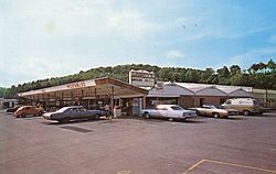
The majority of Newry's businesses are found along the main north-south road, Old Route 220: just north of the town, a storage company and a small motor vehicles store; within Newry, several crafts shops and an electronics repair store; and immediately to the south, the largest business in the town, Leighty's, which comprises a convenience store, a computer systems, parts, and repair store, a golf driving range, a hunting outfitter, a flea market, a flower store, a gas station, and a bathroom and kitchen remodeling store.

Along Patrick Lane, the southmost east-west road in the town, are located a post office, a small apartment building, a furniture store, a used home appliances and furniture store, and St. Patrick's Parish, a Roman Catholic parish comprising a small church, a graveyard, a shrine to Our Lady of Lourdes, and an elementary school.

Along Allegheny Street, the northmost east-west street, one can find a Lutheran church, two bars,(McCoy's Tavern has since been closed down, a dance studio now resides in the building) and town hall.

Events

The two yearly events celebrated by the community, both held by St. Patrick's Parish, are the Lenten fish fries, held in the cafeteria of the school, and the summer festival, held near the end of July or early August on the school playground and in the gymnasium. Both attract visitors from across the Altoona metropolis and greatly benefit the church and school.

Surrounding areas

To the north of Newry, Old Route 220 leads to Duncansville and then to Altoona and other points north.

To the west, the Puzzletown Road curves to the southwest through a few miles of housing developments and into Puzzletown, where it becomes Knob Run Road, continues south-southwest up the Appalachian Plateau, up the mountain of Blue Knob and reaches the town of the same name.

To the south, 220 leads through Leamersville and East Freedom, near McKee, and intersects with Interstate 99; it leads eventually to Bedford.

To the east, the Catfish Road goes through a few miles of sparse farmland, interrupted by a few houses and a monastery, until it intersects Route 36, which leads north to Hollidaysburg and south to Roaring Spring.

Related Research Articles

<span class="mw-page-title-main">Blair County, Pennsylvania</span> County in Pennsylvania, United States

Blair County is a county in the Commonwealth of Pennsylvania. As of the 2020 census, the population was 122,822. Its county seat is Hollidaysburg. The county was created on February 26, 1846, from parts of Huntingdon and Bedford counties.

<span class="mw-page-title-main">Altoona, Florida</span> Census-designated place in Florida

Altoona is an unincorporated community and census-designated place (CDP) in Lake County, Florida, United States. The population was 89 at the 2010 census. It is part of the Orlando–Kissimmee–Sanford Metropolitan Statistical Area.

<span class="mw-page-title-main">Haysville, Pennsylvania</span> Borough in Pennsylvania, United States

Haysville is a borough in Allegheny County, Pennsylvania, United States, along the Ohio River. The population was 81 according to the 2020 census, making it the least-populous municipality in Allegheny County.

<span class="mw-page-title-main">Wall, Pennsylvania</span> Borough in Pennsylvania, United States

Wall is a borough in Allegheny County, Pennsylvania, United States. The population was 519 at the 2020 census.

<span class="mw-page-title-main">St. Clairsville, Pennsylvania</span> Borough in Pennsylvania, United States

St. Clairsville is a borough in Bedford County, Pennsylvania, United States. The population was 76 at the 2020 census.

<span class="mw-page-title-main">Allegheny Township, Blair County, Pennsylvania</span> Township in Pennsylvania, United States

Allegheny Township is a township in Blair County, Pennsylvania, United States. The population was 6,585 at the 2020 census. It is part of the Altoona, Pennsylvania Metropolitan Statistical Area.

<span class="mw-page-title-main">Bellwood, Pennsylvania</span> Borough in Pennsylvania, United States

Bellwood is a borough in Blair County, Pennsylvania, United States. It is part of the Altoona, PA Metropolitan Statistical Area. The population was at 1,829 as of the 2020 census.

<span class="mw-page-title-main">Blair Township, Blair County, Pennsylvania</span> Township in Pennsylvania, United States

Blair Township is a township in Blair County, Pennsylvania, United States. The population was 4,792 at the 2020 census.

<span class="mw-page-title-main">Duncansville, Pennsylvania</span> Borough in Pennsylvania, United States

Duncansville is a borough in Blair County, Pennsylvania, United States. It is part of the Altoona, PA Metropolitan Statistical Area. Duncansville is one of the communities that comprises the Altoona Urban Area. The population was 1,258 at the 2020 census.

<span class="mw-page-title-main">Frankstown Township, Blair County, Pennsylvania</span> Township in Pennsylvania, United States

Frankstown Township is a township in Blair County, Pennsylvania, United States. It is part of the Altoona Metropolitan Statistical Area. The population was 7,399 at the 2020 census. The township was named after Stephen Franks, a pioneer citizen.

<span class="mw-page-title-main">Hollidaysburg, Pennsylvania</span> Place in Pennsylvania, United States

Hollidaysburg is a borough in and the county seat of Blair County in the U.S. Commonwealth of Pennsylvania. It is located on the Juniata River, 5 miles (8 km) south of Altoona and is part of the Altoona, Pennsylvania, metropolitan statistical area. In 1900, 2,998 people lived in the borough, in 1910, 3,734 lived there, and in 1940, 5,910 residents were counted. The population was 5,641 at the 2020 census. Coal, iron ore, ganister, and limestone are found in the vicinity. In the past, the borough had foundries and machine shops, a silk mill, car works and classification yards.

<span class="mw-page-title-main">Williamsburg, Pennsylvania</span> Borough in Pennsylvania, United States

Williamsburg in Morrisons Cove, is a borough in Blair County, Pennsylvania, United States. The population was 1,241 at the 2020 census. It is part of the Altoona, PA Metropolitan Statistical Area.

<span class="mw-page-title-main">Allegheny Township, Cambria County, Pennsylvania</span> Township in Pennsylvania, United States

Allegheny Township is a township in Cambria County, Pennsylvania, United States. It is part of the Johnstown, Pennsylvania Metropolitan Statistical Area. The population was 2,851 at the 2010 census, up from 2,498 at the 2000 census.

<span class="mw-page-title-main">Cresson, Pennsylvania</span> Borough in Pennsylvania, United States

Cresson is a borough in Cambria County, Pennsylvania, United States. Cresson is 80 miles (130 km) east of Pittsburgh. It is above 2,000 feet (600 m) in elevation. Lumber, coal, and coke yards were industries that had supported the population, which numbered 1,470 in 1910. The borough is part of the Johnstown Metropolitan Statistical Area, although state and local sources list it as part of the Altoona area due to being much closer to that city. The population of Cresson at the 2010 census was 1,711.

<span class="mw-page-title-main">Gallitzin, Pennsylvania</span> Borough in Pennsylvania, United States

Gallitzin is a borough in Cambria County, Pennsylvania, United States. It is bordered by Gallitzin Township and Tunnelhill, all of which sit astride the Eastern continental divide. Tunnel Hill and Gallitzin both are pierced by railroad tunnels shortening the necessary ascent for rails crossing the Allegheny Front onto the Allegheny Plateau which encompasses the towns' terrains. Topping the gaps of the Allegheny, the area is one of only five major breaks in the Appalachians allowing east–west transportation corridors before the advent of 20th century technologies.

<span class="mw-page-title-main">Loretto, Pennsylvania</span> Borough in Pennsylvania, United States

Loretto is a borough in Cambria County, Pennsylvania, United States. As of the 2010 census it had a population of 1,302. Like the rest of Cambria County, it is part of the Johnstown, Pennsylvania Metropolitan Statistical Area. Loretto is the home of Saint Francis University.

<span class="mw-page-title-main">South Fork, Pennsylvania</span> Borough in Pennsylvania, United States

South Fork is a borough in Cambria County, Pennsylvania, United States. It is part of the Johnstown, Pennsylvania Metropolitan Statistical Area. The population was 928 at the 2010 census, down from 1,138 at the 2000 census.

<span class="mw-page-title-main">Foxburg, Pennsylvania</span> Borough in Pennsylvania, United States

Foxburg is a borough in Clarion County, Pennsylvania, United States. It is located along the east bank of the Allegheny River, about 2 miles (3 km) north of the mouth of the Clarion River. As of the 2020 census it had a population of 181.

<span class="mw-page-title-main">Falls Creek, Pennsylvania</span> Borough in Pennsylvania, United States

Falls Creek is a borough located in Jefferson and Clearfield counties in Pennsylvania, United States. The population was 1,036 at the 2020 census. Of this, 994 were in Jefferson County, and 42 were in Clearfield County.

<span class="mw-page-title-main">Hollidaysburg Area School District</span> School district in Pennsylvania

The Hollidaysburg Area School District is a midsized, suburban public school district which is based in Hollidaysburg, Pennsylvania. It serves the boroughs of Duncansville, Hollidaysburg, and Newry, and the townships of Allegheny, Blair, Frankstown, and Juniata.

References

  1. "ArcGIS REST Services Directory". United States Census Bureau. Retrieved October 12, 2022.
  2. 1 2 U.S. Geological Survey Geographic Names Information System: Newry, Pennsylvania
  3. 1 2 "Census Population API". United States Census Bureau. Retrieved Oct 12, 2022.
  4. 1 2 Bureau, US Census. "City and Town Population Totals: 2020—2021". Census.gov. US Census Bureau. Retrieved August 31, 2022.
  5. "US Gazetteer files: 2010, 2000, and 1990". United States Census Bureau. 2011-02-12. Retrieved 2011-04-23.
  6. "Census of Population and Housing". U.S. Census Bureau. Retrieved 11 December 2013.
  7. 1 2 "U.S. Census website". United States Census Bureau . Retrieved 2008-01-31.
  8. "Incorporated Places and Minor Civil Divisions Datasets: Subcounty Resident Population Estimates: April 1, 2010 to July 1, 2012". Population Estimates. U.S. Census Bureau. Archived from the original on 11 June 2013. Retrieved 11 December 2013.