Ashville, Pennsylvania

Last updated

Ashville, Pennsylvania
Borough
Ashville, Pennsylvania (6937408068).jpg
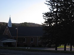
St. Thomas Aquinas Church in Ashville
Cambria County Pennsylvania Incorporated and Unincorporated areas Ashville Highlighted.svg
Location of Ashville in Cambria County, Pennsylvania.
Map of Pennsylvania highlighting Cambria County.svg
Map of Cambria County, Pennsylvania
USA Pennsylvania location map.svg
Red pog.svg
Ashville
Location in Pennsylvania
Usa edcp location map.svg
Red pog.svg
Ashville
Ashville (the United States)
North America laea location map.svg
Red pog.svg
Ashville
Ashville (North America)
Coordinates: 40°33′33″N78°32′53″W / 40.55917°N 78.54806°W / 40.55917; -78.54806
Country United States
State Pennsylvania
County Cambria
Settled1842
Incorporated1887
Government
  TypeBorough Council
Area
[1]
  Total
0.18 sq mi (0.47 km2)
  Land0.18 sq mi (0.47 km2)
  Water0.00 sq mi (0.00 km2)
Elevation
[2]
1,680 ft (510 m)
Population
 (2020) [3]
  Total
213
  Density1,163.93/sq mi (450.27/km2)
Time zone UTC-5 (Eastern (EST))
  Summer (DST) UTC-4 (EDT)
Zip code
16613
Area code 814
FIPS code 42-03296
GNIS feature ID1215008 [2]

Ashville is a borough in Cambria County, Pennsylvania, United States. It is part of the Johnstown, Pennsylvania Metropolitan Statistical Area. However, it is much closer to Altoona and is often considered a suburb of the latter. The population was 213 at the 2020 census. [4]

Contents

Geography

Ashville is located in northeastern Cambria County. It is in the valley of Clearfield Creek, a northward-flowing tributary of the West Branch Susquehanna River, and the trace of the eastern continental divide either passes through or is just east of town, [5] in the abutting Gallitzin Township to the south.

According to the United States Census Bureau, the borough of Ashville has a total area of 0.18 square miles (0.46 km2), all land. [4]

Demographics

Historical population
CensusPop.Note
1890 289
1900 39336.0%
1910 384−2.3%
1920 44716.4%
1930 4868.7%
1940 5115.1%
1950 441−13.7%
1960 422−4.3%
1970 409−3.1%
1980 383−6.4%
1990 306−20.1%
2000 279−8.8%
2010 227−18.6%
2020 213−6.2%
U.S. Decennial Census [6] [3]

As of the census [7] of 2010, there were 227 people, 102 households, and 62 families residing in the borough. The population density was 1,289.9 inhabitants per square mile (498.0/km2). There were 111 housing units at an average density of 630.8 per square mile (243.6/km2). The racial makeup of the borough was 97.4% White, 0.9% Black or African American, 0.4% Native Hawaiian, 0.9% from other races, and 0.4% from two or more races. Hispanic or Latino of any race were 0.9% of the population.

There were 102 households, out of which 27.5% had children under the age of 18 living with them, 34.3% were married couples living together, 19.6% had a female householder with no husband present, and 33.6% were non-families. 39.2% of all households were made up of individuals, and 17.7% had someone living alone who was 65 years of age or older. The average household size was 2.23 and the average family size was 2.87.

In the borough the population was spread out, with 24.2% under the age of 18, 7.5% from 18 to 24, 22.9% from 25 to 44, 22.0% from 45 to 64, and 23.3% who were 65 years of age or older. The median age was 40 years. For every 100 females there were 102.7 males. For every 100 females age 18 and over, there were 95.5 males.

The median income for a household in the borough was $38,409, and the median income for a family was $45,208. Males had a median income of $35,417 versus $36,667 for females. The per capita income for the borough was $22,999. About 12.3% of families and 15.6% of the population were below the poverty line, including 27.7% of those under the age of eighteen and none of those sixty five or over.

References

  1. "ArcGIS REST Services Directory". United States Census Bureau. Retrieved October 12, 2022.
  2. 1 2 U.S. Geological Survey Geographic Names Information System: Ashville, Pennsylvania
  3. 1 2 "Census Population API". United States Census Bureau. Retrieved October 12, 2022.
  4. 1 2 "Geographic Identifiers: 2010 Demographic Profile Data (G001): Ashville borough, Pennsylvania". U.S. Census Bureau, American Factfinder. Archived from the original on March 11, 2015. Retrieved March 11, 2015.
  5. See commons source topomap for Kittanning Run, .
  6. "Census of Population and Housing". Census.gov. Retrieved June 4, 2016.
  7. "U.S. Census website". United States Census Bureau . Retrieved January 31, 2008.