Loretto, Pennsylvania

Last updated
Loretto, Pennsylvania
Borough
Loretto01.jpg
The main house, cascades, and gardens of "Immergrün", Charles M. Schwab's retreat in Loretto
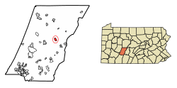
Cambria County Pennsylvania Incorporated and Unincorporated areas Loretto Highlighted.svg
Location of Loretto in Cambria County, Pennsylvania.
USA Pennsylvania location map.svg
Red pog.svg
Loretto
Coordinates: 40°30′23″N78°38′10″W / 40.50639°N 78.63611°W / 40.50639; -78.63611 Coordinates: 40°30′23″N78°38′10″W / 40.50639°N 78.63611°W / 40.50639; -78.63611
Country United States
State Pennsylvania
County Cambria
Settled1788
Incorporated1845
Government
  TypeBorough council
Area
[1]
  Total0.98 sq mi (2.55 km2)
  Land0.98 sq mi (2.55 km2)
  Water0.00 sq mi (0.00 km2)
Elevation
[2]
1,952 ft (595 m)
Population
 (2020) [3]
  Total1,196
  Density1,215.45/sq mi (469.48/km2)
Time zone UTC-5 (Eastern (EST))
  Summer (DST) UTC-4 (EDT)
ZIP code
15940
Area code 814
FIPS code 42-44704
GNIS feature ID1215028 [2]

Loretto is a borough in Cambria County, Pennsylvania, United States. As of the 2010 census it had a population of 1,302. [4] Like the rest of Cambria County, it is part of the Johnstown, Pennsylvania Metropolitan Statistical Area. Loretto is the home of Saint Francis University.

Contents

Geography

Loretto is located in east-central Cambria County at 40°30′23″N78°38′10″W / 40.50639°N 78.63611°W / 40.50639; -78.63611 (40.506355, -78.636066). [5] It is 6 miles (10 km) east of Ebensburg, the Cambria County seat, and 17 miles (27 km) west of Altoona. Johnstown is 25 miles (40 km) to the southwest.

According to the U.S. Census Bureau, the borough of Loretto has a total area of 0.97 square miles (2.5 km2), all land. [4]

Saint Francis University, an institute of higher learning with an enrollment of 2,210, [6] occupies the southwestern quadrant of the borough.

Basilica of St. Michael the Archangel Basilica of St. Michael the Archangel - Loretto, Pennsylvania 01.jpg
Basilica of St. Michael the Archangel

History

Loretto was founded in 1799 by Demetrius Augustine Gallitzin as the first English-speaking Catholic settlement west of the Allegheny Front. He named it after the town of Loreto, Italy, [7] site of a Catholic place of pilgrimage. Loretto was built adjoining the original settlement founded by Captain Michael McGuire, a Revolutionary War veteran, in 1788. [8] In his will, Captain McGuire donated land to the Catholic Church on which Prince Gallitzin built St. Michael's Church in 1799.

Federal Correctional Institution, Loretto, is a U.S. federal prison located 0.5 miles (0.80 km) southeast of Loretto, on the site of a former Catholic seminary.

Demographics

Historical population
CensusPop.Note
1850 193
1860 25632.6%
1870 2809.4%
1880 2800.0%
1890 236−15.7%
1900 2401.7%
1910 2462.5%
1920 42271.5%
1930 352−16.6%
1940 50443.2%
1950 86371.2%
1960 1,33855.0%
1970 1,66124.1%
1980 1,395−16.0%
1990 1,072−23.2%
2000 1,19011.0%
2010 1,3029.4%
2020 1,196−8.1%
Sources: [9] [10] [11] [3]

At the 2000 census there were 1,190 people, 133 households, and 82 families living in the borough. The population density was 1,167.3 people per square mile (450.7 people/km2). There were 153 housing units at an average density of 150.1 per square mile (58.0/km2). The racial makeup of the borough was 96.39% White, 2.52% African American, 0.50% Asian, 0.08% Pacific Islander, 0.25% from other races, and 0.25% from two or more races. Hispanic or Latino of any race were 1.26%. [10]

There were 133 households, 21.8% had children under the age of 18 living with them, 51.1% were married couples living together, 6.0% had a female householder with no husband present, and 37.6% were non-families. 27.8% of households were made up of individuals, and 12.0% were one person aged 65 or older. The average household size was 2.52 and the average family size was 3.20.

The age distribution was 5.5% under the age of 18, 71.6% from 18 to 24, 8.7% from 25 to 44, 7.2% from 45 to 64, and 6.9% 65 or older. The median age was 21 years. For every 100 females there were 70.7 males. For every 100 females age 18 and over, there were 69.8 males. The median household income was $30,357 and the median family income was $40,750. Males had a median income of $30,417 versus $16,250 for females. The per capita income for the borough was $7,125. About 2.7% of families and 9.1% of the population were below the poverty line, including none of those under age 18 and 2.6% of those age 65 or over.

Notable people

Related Research Articles

<span class="mw-page-title-main">Brownstown, Cambria County, Pennsylvania</span> Borough in Pennsylvania, United States

Brownstown is a borough in Cambria County, Pennsylvania, United States. The population was 744 at the 2010 census. It is part of the Johnstown, Pennsylvania Metropolitan Statistical Area and also part of Johnstown's urban area.

<span class="mw-page-title-main">Cambria County, Pennsylvania</span> County in Pennsylvania, United States

Cambria County is a county in the Commonwealth of Pennsylvania. As of the 2020 census, the population was 133,472. Its county seat is Ebensburg. The county was created on March 26, 1804, from parts of Bedford, Huntingdon, and Somerset Counties and later organized in 1807. It was named for the nation of Wales, which in Latin is known as "Cambria".

<span class="mw-page-title-main">Adams Township, Cambria County, Pennsylvania</span> Township in Pennsylvania, United States

Adams Township in Cambria County, Pennsylvania, United States, is a township that is part of the Johnstown, Pennsylvania Metropolitan Statistical Area. The population was 5,972 at the 2010 census, down from 6,495 at the 2000 census.

<span class="mw-page-title-main">Ashville, Pennsylvania</span> Borough in Pennsylvania, United States

Ashville is a borough in Cambria County, Pennsylvania, United States. It is part of the Johnstown, Pennsylvania Metropolitan Statistical Area. However, it is much closer to Altoona and is often considered a suburb of the latter. The population was 213 at the 2020 census.

<span class="mw-page-title-main">Carrolltown, Pennsylvania</span> Borough in Pennsylvania, United States

Carrolltown is a borough in Cambria County, Pennsylvania, United States. The population was 853 at the 2010 census, down from 1,049 at the 2000 census. It is part of the Johnstown, Pennsylvania Metropolitan Statistical Area.

<span class="mw-page-title-main">Chest Township, Cambria County, Pennsylvania</span> Township in Pennsylvania, United States

Chest Township is a township in Cambria County, Pennsylvania, United States. The population was 458 at the 2020 census. It is part of the Johnstown, Pennsylvania Metropolitan Statistical Area.

<span class="mw-page-title-main">Cresson, Pennsylvania</span> Borough in Pennsylvania, United States

Cresson is a borough in Cambria County, Pennsylvania, United States. Cresson is 80 miles (130 km) east of Pittsburgh. It is above 2,000 feet (600 m) in elevation. Lumber, coal, and coke yards were industries that had supported the population, which numbered 1,470 in 1910. The borough is part of the Johnstown Metropolitan Statistical Area, although state and local sources list it as part of the Altoona area due to being much closer to that city. The population of Cresson at the 2010 census was 1,711.

<span class="mw-page-title-main">Daisytown, Pennsylvania</span> Borough in Pennsylvania, United States

Daisytown is a borough in Cambria County, Pennsylvania, United States. It is part of the Johnstown, Pennsylvania Metropolitan Statistical Area. The population was 326 at the 2010 census.

<span class="mw-page-title-main">East Conemaugh, Pennsylvania</span> Borough in Pennsylvania, United States

East Conemaugh is a borough in Cambria County, Pennsylvania, United States. It is part of the Johnstown, Pennsylvania Metropolitan Statistical Area. The population was 1,220 at the 2010 census.

<span class="mw-page-title-main">Ehrenfeld, Pennsylvania</span> Borough in Pennsylvania, United States

Ehrenfeld is a borough in Cambria County, Pennsylvania, United States. It is part of the Johnstown, Pennsylvania Metropolitan Statistical Area. The population was 228 at the 2010 census.

<span class="mw-page-title-main">Ferndale, Pennsylvania</span> Borough in Pennsylvania, United States

Ferndale is a borough in Cambria County, Pennsylvania, United States. It is part of the Johnstown, Pennsylvania Metropolitan Statistical Area. The population was 1,636 at the 2010 census, down from 1,834 at the 2000 census.

<span class="mw-page-title-main">Gallitzin, Pennsylvania</span> Borough in Pennsylvania, United States

Gallitzin is a borough in Cambria County, Pennsylvania, United States. It is bordered by Gallitzin Township and Tunnelhill, all of which sit astride the Eastern continental divide. Tunnel Hill and Gallitzin both are pierced by railroad tunnels shortening the necessary ascent for rails crossing the Allegheny Front onto the Allegheny Plateau which encompasses the towns' terrains. Topping the gaps of the Allegheny, the area is one of only five major breaks in the Appalachians allowing east–west transportation corridors before the advent of 20th century technologies.

<span class="mw-page-title-main">Gallitzin Township, Cambria County, Pennsylvania</span> Township in Pennsylvania, United States

Gallitzin Township is a township in Cambria County, Pennsylvania, United States. The township nearly surrounds, but is a separate entity from, Gallitzin borough. As of the 2010 census, the township population was 1,324. It is part of the Johnstown, Pennsylvania Metropolitan Statistical Area.

<span class="mw-page-title-main">Northern Cambria, Pennsylvania</span> Borough in Pennsylvania, United States

Northern Cambria is a borough in Cambria County, Pennsylvania, United States. It is part of the Johnstown, Pennsylvania Metropolitan Statistical Area. The population was 3,835 at the 2010 census.

<span class="mw-page-title-main">Richland Township, Cambria County, Pennsylvania</span> Township in Pennsylvania, United States

Richland Township is a township in Cambria County, Pennsylvania, United States. The population was 12,814 at the 2010 census. It is part of the Johnstown, Pennsylvania Metropolitan Statistical Area.

<span class="mw-page-title-main">Scalp Level, Pennsylvania</span> Borough in Pennsylvania, United States

Scalp Level is a borough in Cambria County, Pennsylvania, United States. It is part of the Johnstown, Pennsylvania Metropolitan Statistical Area. The population was 778 at the 2010 census.

<span class="mw-page-title-main">South Fork, Pennsylvania</span> Borough in Pennsylvania, United States

South Fork is a borough in Cambria County, Pennsylvania, United States. It is part of the Johnstown, Pennsylvania Metropolitan Statistical Area. The population was 928 at the 2010 census, down from 1,138 at the 2000 census.

<span class="mw-page-title-main">White Township, Cambria County, Pennsylvania</span> Township in Pennsylvania, United States

White Township is a township in Cambria County, Pennsylvania, United States. The population was 836 at the 2010 census. It is part of the Johnstown, Pennsylvania Metropolitan Statistical Area.

<span class="mw-page-title-main">Wilmore, Pennsylvania</span> Borough in Pennsylvania, United States

Wilmore is a borough in Cambria County, Pennsylvania, United States. It is part of the Johnstown, Pennsylvania Metropolitan Statistical Area. The population was 225 at the 2010 census.

<span class="mw-page-title-main">Franklin, Cambria County, Pennsylvania</span> Borough in Pennsylvania, United States

Franklin is a borough in Cambria County, Pennsylvania, United States. It is part of the Johnstown, Pennsylvania Metropolitan Statistical Area. At the 2010 census the borough population was 323, down from 442 at the 2000 census.

References

  1. "ArcGIS REST Services Directory". United States Census Bureau. Retrieved October 12, 2022.
  2. 1 2 U.S. Geological Survey Geographic Names Information System: Loretto, Pennsylvania
  3. 1 2 "Census Population API". United States Census Bureau. Retrieved Oct 12, 2022.
  4. 1 2 "Geographic Identifiers: 2010 Demographic Profile Data (G001): Loretto borough, Pennsylvania". U.S. Census Bureau, American Factfinder. Archived from the original on March 17, 2015. Retrieved March 17, 2015.
  5. "US Gazetteer files: 2010, 2000, and 1990". United States Census Bureau. 2011-02-12. Retrieved 2011-04-23.
  6. About Saint Francis University Archived 2007-07-26 at the Wayback Machine
  7. Gannett, Henry (1905). The Origin of Certain Place Names in the United States. U.S. Government Printing Office. p.  190.
  8. Adams, Edmund (1989). Catholic Trails West: Founding Catholic Families of Pennsylvania, volume 2. Baltimore: Gateway Press. p. 354. ISBN   0806312122.
  9. "Census of Population and Housing". U.S. Census Bureau. Retrieved 11 December 2013.
  10. 1 2 "U.S. Census website". United States Census Bureau . Retrieved 2008-01-31.
  11. "Incorporated Places and Minor Civil Divisions Datasets: Subcounty Resident Population Estimates: April 1, 2010 to July 1, 2012". Population Estimates. U.S. Census Bureau. Archived from the original on 11 June 2013. Retrieved 11 December 2013.