Lilly, Pennsylvania

Last updated
Lilly, Pennsylvania
Borough
Lilly Bridge.jpg
The Lilly Bridge, a historic site in the borough
Cambria County Pennsylvania Incorporated and Unincorporated areas Lilly Highlighted.svg
Location of Lilly in Cambria County, Pennsylvania.
USA Pennsylvania location map.svg
Red pog.svg
Lilly
Coordinates: 40°25′30″N78°37′14″W / 40.42500°N 78.62056°W / 40.42500; -78.62056 Coordinates: 40°25′30″N78°37′14″W / 40.42500°N 78.62056°W / 40.42500; -78.62056
Country United States
State Pennsylvania
County Cambria
Settled1806
Incorporated1883
Government
  TypeBorough council
  MayorMichael Eckenrode
Area
[1]
  Total0.52 sq mi (1.35 km2)
  Land0.52 sq mi (1.35 km2)
  Water0.00 sq mi (0.00 km2)
Elevation
[2]
1,896 ft (578 m)
Population
 (2020) [3]
  Total879
  Density1,683.91/sq mi (650.10/km2)
Time zone UTC-5 (Eastern (EST))
  Summer (DST) UTC-4 (EDT)
ZIP code
15938
Area code 814
FIPS code 42-43248
GNIS feature ID1215026 [2]
Website lillyboro.com

Lilly is a borough in Cambria County, Pennsylvania, United States. It is part of the Johnstown, Pennsylvania Metropolitan Statistical Area. The population was 968 at the 2010 census. [4]

Contents

History

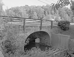
The Lilly Bridge was listed on the National Register of Historic Places in 1988. [5]

Geography

Lilly is located in eastern Cambria County at 40°25′30″N78°37′14″W / 40.42500°N 78.62056°W / 40.42500; -78.62056 (40.425000, -78.620434), [6] in the valley of the Little Conemaugh River near its headwaters. Pennsylvania Route 53 passes through the borough, leading north 2 miles (3 km) to U.S. Route 22 near Cresson.

According to the United States Census Bureau, Lilly has a total area of 0.50 square miles (1.3 km2), all land. [4]

Demographics

Historical population
CensusPop.Note
1890 915
1900 1,27639.5%
1910 1,63828.4%
1920 2,34643.2%
1930 2,163−7.8%
1940 2,2825.5%
1950 1,898−16.8%
1960 1,642−13.5%
1970 1,429−13.0%
1980 1,4622.3%
1990 1,162−20.5%
2000 948−18.4%
2010 9682.1%
2020 879−9.2%
Sources: [7] [8] [9] [3]

As of the census [8] of 2000, there were 948 people, 407 households, and 269 families residing in the borough. The population density was 1,952.4 people per square mile (753.8 people/km2). There were 439 housing units at an average density of 904.1 per square mile (349.1/km2). The racial makeup of the borough was 99.47% White, 0.21% Native American, 0.11% Asian, 0.11% Pacific Islander, and 0.11% from two or more races.

There were 407 households, out of which 23.3% had children under the age of 18 living with them, 49.1% were married couples living together, 12.8% had a female householder with no husband present, and 33.9% were non-families. 31.9% of all households were made up of individuals, and 17.7% had someone living alone who was 65 years of age or older. The average household size was 2.32 and the average family size was 2.91.

In the borough the population was spread out, with 18.8% under the age of 18, 7.4% from 18 to 24, 26.2% from 25 to 44, 26.8% from 45 to 64, and 20.9% who were 65 years of age or older. The median age was 44 years. For every 100 females there were 88.8 males. For every 100 females age 18 and over, there were 89.7 males.

The median income for a household in the borough was $27,917, and the median income for a family was $38,750. Males had a median income of $29,063 versus $18,929 for females. The per capita income for the borough was $15,984. About 3.8% of families and 7.8% of the population were below the poverty line, including 3.4% of those under age 18 and 12.7% of those age 65 or over.

Central Mainline Sewer Authority

Sewage treatment in Lilly is provided by the Central Mainline Sewer Authority. A dedication ceremony was held on August 21, 2006, by local congressman John Murtha. Total costs of the system was $10 million, and construction took 14 years. Central Mainline serves over 2,000 customers. [10]

Related Research Articles

<span class="mw-page-title-main">Brownstown, Cambria County, Pennsylvania</span> Borough in Pennsylvania, United States

Brownstown is a borough in Cambria County, Pennsylvania, United States. The population was 744 at the 2010 census. It is part of the Johnstown, Pennsylvania Metropolitan Statistical Area and also part of Johnstown's urban area.

<span class="mw-page-title-main">Duncansville, Pennsylvania</span> Borough in Pennsylvania, United States

Duncansville is a borough in Blair County, Pennsylvania, United States. It is part of the Altoona, PA Metropolitan Statistical Area. Duncansville is one of the communities that comprises the Altoona Urban Area. The population was 1,258 at the 2020 census.

<span class="mw-page-title-main">Carrolltown, Pennsylvania</span> Borough in Pennsylvania, United States

Carrolltown is a borough in Cambria County, Pennsylvania, United States. The population was 853 at the 2010 census, down from 1,049 at the 2000 census. It is part of the Johnstown, Pennsylvania Metropolitan Statistical Area.

<span class="mw-page-title-main">Cassandra, Pennsylvania</span> Borough in Pennsylvania, United States

Cassandra is a borough in Cambria County, Pennsylvania, United States. The population was 147 at the 2010 census. It is part of the Johnstown, Pennsylvania Metropolitan Statistical Area.

<span class="mw-page-title-main">Chest Springs, Pennsylvania</span> Borough in Pennsylvania, United States

Chest Springs is a borough in Cambria County, Pennsylvania, United States. It is part of the Johnstown, Pennsylvania Metropolitan Statistical Area. The population was 149 at the 2010 census.

<span class="mw-page-title-main">Cresson Township, Cambria County, Pennsylvania</span> Township in Pennsylvania, United States

Cresson Township is a township in Cambria County, Pennsylvania, United States. The population was 2,820 at the 2020 census. The township surrounds the boroughs of Cresson and Sankertown but is separate from them. It is part of the Johnstown, Pennsylvania Metropolitan Statistical Area.

<span class="mw-page-title-main">Daisytown, Pennsylvania</span> Borough in Pennsylvania, United States

Daisytown is a borough in Cambria County, Pennsylvania, United States. It is part of the Johnstown, Pennsylvania Metropolitan Statistical Area. The population was 326 at the 2010 census.

<span class="mw-page-title-main">Dale, Pennsylvania</span> Borough in Pennsylvania, United States

Dale is a borough in Cambria County, Pennsylvania, United States. It is part of the Johnstown, Pennsylvania Metropolitan Statistical Area. The population was 1,234 at the 2010 census, down from 1,503 at the 2000 census.

<span class="mw-page-title-main">Ehrenfeld, Pennsylvania</span> Borough in Pennsylvania, United States

Ehrenfeld is a borough in Cambria County, Pennsylvania, United States. It is part of the Johnstown, Pennsylvania Metropolitan Statistical Area. The population was 228 at the 2010 census.

<span class="mw-page-title-main">Ferndale, Pennsylvania</span> Borough in Pennsylvania, United States

Ferndale is a borough in Cambria County, Pennsylvania, United States. It is part of the Johnstown, Pennsylvania Metropolitan Statistical Area. The population was 1,636 at the 2010 census, down from 1,834 at the 2000 census.

<span class="mw-page-title-main">Gallitzin Township, Cambria County, Pennsylvania</span> Township in Pennsylvania, United States

Gallitzin Township is a township in Cambria County, Pennsylvania, United States. The township nearly surrounds, but is a separate entity from, Gallitzin borough. As of the 2010 census, the township population was 1,324. It is part of the Johnstown, Pennsylvania Metropolitan Statistical Area.

<span class="mw-page-title-main">Geistown, Pennsylvania</span> Borough in Pennsylvania, United States

Geistown is a borough in Cambria County, Pennsylvania, United States. It is part of the Johnstown, Pennsylvania Metropolitan Statistical Area. The population was 2,467 at the 2010 census.

<span class="mw-page-title-main">Hastings, Pennsylvania</span> Borough in Pennsylvania, United States

Hastings is a borough in Cambria County, Pennsylvania, United States. It is part of the Johnstown, Pennsylvania Metropolitan Statistical Area. The population was 1,278 at the 2010 census.

<span class="mw-page-title-main">Loretto, Pennsylvania</span> Borough in Pennsylvania, United States

Loretto is a borough in Cambria County, Pennsylvania, United States. As of the 2010 census it had a population of 1,302. Like the rest of Cambria County, it is part of the Johnstown, Pennsylvania Metropolitan Statistical Area. Loretto is the home of Saint Francis University.

<span class="mw-page-title-main">Portage Township, Cambria County, Pennsylvania</span> Township in Pennsylvania, United States

Portage Township is a township in Cambria County, Pennsylvania, United States. It surrounds the borough of Portage. The township population was 3,640 at the 2010 census. It is part of the Johnstown, Pennsylvania Metropolitan Statistical Area.

<span class="mw-page-title-main">Sankertown, Pennsylvania</span> Borough in Pennsylvania, United States

Sankertown is a borough in Cambria County, Pennsylvania, United States. It is part of the Johnstown, Pennsylvania Metropolitan Statistical Area. The population was 675 at the 2010 census.

<span class="mw-page-title-main">South Fork, Pennsylvania</span> Borough in Pennsylvania, United States

South Fork is a borough in Cambria County, Pennsylvania, United States. It is part of the Johnstown, Pennsylvania Metropolitan Statistical Area. The population was 928 at the 2010 census, down from 1,138 at the 2000 census.

<span class="mw-page-title-main">Washington Township, Cambria County, Pennsylvania</span> Township in Pennsylvania, United States

Washington Township is a township in Cambria County, Pennsylvania, United States. As of the 2010 census, the township population was 875. It is part of the Johnstown, Pennsylvania Metropolitan Statistical Area.

<span class="mw-page-title-main">Tunnelhill, Pennsylvania</span> Borough in Pennsylvania, United States

Tunnelhill is a borough that is located in Cambria and Blair counties in Pennsylvania, United States. The population was 363 at the 2010 census. Of these, 245 were in Cambria County, and 118 were in Blair County. It is part of the Altoona, PA Metropolitan Statistical Area. Tunnelhill is named after the many railroad tunnels of the Pennsylvania Railroad near here known as the Gallitzin Tunnels.

<span class="mw-page-title-main">Franklin, Cambria County, Pennsylvania</span> Borough in Pennsylvania, United States

Franklin is a borough in Cambria County, Pennsylvania, United States. It is part of the Johnstown, Pennsylvania Metropolitan Statistical Area. At the 2010 census the borough population was 323, down from 442 at the 2000 census.

References

  1. "ArcGIS REST Services Directory". United States Census Bureau. Retrieved October 12, 2022.
  2. 1 2 U.S. Geological Survey Geographic Names Information System: Lilly, Pennsylvania
  3. 1 2 "Census Population API". United States Census Bureau. Retrieved Oct 12, 2022.
  4. 1 2 "Geographic Identifiers: 2010 Demographic Profile Data (G001): Lilly borough, Pennsylvania". U.S. Census Bureau, American Factfinder. Archived from the original on March 16, 2015. Retrieved March 15, 2015.
  5. "National Register Information System". National Register of Historic Places . National Park Service. July 9, 2010.
  6. "US Gazetteer files: 2010, 2000, and 1990". United States Census Bureau. 2011-02-12. Retrieved 2011-04-23.
  7. "Census of Population and Housing". U.S. Census Bureau. Retrieved 11 December 2013.
  8. 1 2 "U.S. Census website". United States Census Bureau . Retrieved 2008-01-31.
  9. "Incorporated Places and Minor Civil Divisions Datasets: Subcounty Resident Population Estimates: April 1, 2010 to July 1, 2012". Population Estimates. U.S. Census Bureau. Archived from the original on 11 June 2013. Retrieved 11 December 2013.
  10. "Central Mainline history". www.washington-cmsa.com. Archived from the original on April 7, 2016. Retrieved June 8, 2016.