Radnor Township, Pennsylvania

Last updated

Radnor Township
Township of Radnor
MilePostRadnor.JPG
Wayne Hotel Wayne PA b.JPG
RadnorFriendsMeetinghouse.jpg
Garrett-hill-july-4.JPG
VillanovaMonastery.jpg
Villanova University A panoramic shot.jpg
SealOfRadnorTownshipDelcoPA 01.png
WordmarkOfRadnorTownshipDelcoPA.jpg
Etymology: Named for Radnorshire, Wales
Motto: 
"Best of the Main Line"
Delaware County Pennsylvania incorporated and unincorporated areas Radnor highlighted.svg
Location in Delaware County and the state of Pennsylvania.
Pennsylvania in United States (US48).svg
Location of Pennsylvania in the United States
Coordinates: 40°2′11″N75°22′21″W / 40.03639°N 75.37250°W / 40.03639; -75.37250
CountryFlag of the United States.svg  United States
State Flag of Pennsylvania.svg  Pennsylvania
County Delaware
Historic colony Province of Pennsylvania
Founded1682
Incorporated1901
Founded by William Penn
Government
  Type Board of Commissioners
  Township ManagerWilliam White [1]
Area
[2]
  Total13.79 sq mi (35.72 km2)
  Land13.78 sq mi (35.68 km2)
  Water0.01 sq mi (0.04 km2)
Elevation
381 ft (116 m)
Population
 (2010)
  Total31,531
  Estimate 
(2019) [3]
31,875
  Density2,309.38/sq mi (891.64/km2)
Demonym Radnorite [4]
Time zone UTC-5 (EST)
  Summer (DST) UTC-4 (EDT)
ZIP Code
190xx
Area codes 484 and 610
FIPS code 42-045-63264
Interstates I-476.svg
U.S. Routes US 30.svg
Commuter rail Paoli/Thorndale Line
Rapid transit Norristown High Speed Line
Website Radnor Township

Radnor Township, often called simply Radnor, is a first class township with home rule status in Delaware County, Pennsylvania, United States.

Contents

Historically regarded as part of Philadelphia’s famed Main Line, the township’s population was 31,875 as of the 2019 United States census. [3] Radnor Township is the largest municipality in Delaware County by land area and the fourth-largest by population, following Upper Darby Township, Haverford Township, and Chester. [5]

Radnor Township is one of the oldest municipalities in Pennsylvania. Radnor Township was founded as a part of the Welsh tract. The original settlers were Welsh-speaking Quakers, led by John Roberts, in an attempt to establish a barony of Wales in Pennsylvania. [6] In about 1681, a group of Welsh Quakers met with William Penn to secure a grant of land in which they could conduct their affairs in their own language. The parties agreed on a tract covering 40,000 acres (160 km2), to be constituted as a separate county whose people and government could conduct their affairs in Welsh. William Penn, an English Quaker, laid out the township in an elongated rectangle located parallel to the Schuylkill River, and the borders of the township have remained unchanged since its founding in 1682. [7]

In 1717, the Welsh Friends built a meeting house on a trail made by the Susquehannock Indians in Radnor Township. Radnor Township grew around the meeting house and remained the center of population of the township for 200 years. The new township was named Radnor after the county in Wales called Radnorshire. The influence of the Welsh, some of whom were forced by heavy taxation to sell their land, waned in the latter half of the 18th century. A hint of Radnor's beginnings remain in the names of streets and places evident throughout the community, such as the St. Davids neighborhood, named for Saint David, the patron saint of Wales. [7]

There are a number colleges and universities located in Radnor Township, of which the two largest are Villanova University and Cabrini University. The Valley Forge Military Academy and College is located in the neighborhood of Wayne and Eastern University is located in the neighborhood of St. Davids. [8]

History

Colonial era

In 1681, Richard Davies purchased 5,000 acres from William Penn. These lands were sold to various purchasers and were mainly in the location of current Radnor Township. [9] The township was part of the Welsh Tract and was named for Radnorshire in Wales. [10] In 1717, the Welsh Friends erected a Quaker meetinghouse (Radnor Friends Meetinghouse) near what is now the intersection of Conestoga Road and Sproul Road at the geographic center of the township. The new town, "Radnorville", later known as the community of "Ithan" after nearby Ithan Creek, grew around the meetinghouse. The Welsh influence waned in the late 18th century as many left the area due to high taxation. Stone monuments were erected in various locations throughout the township in the late 20th century to commemorate the township's Welsh heritage.

18th century

In 1794, the Philadelphia and Lancaster Turnpike was built through Radnor Township, making it the first toll road in the United States, and connecting the cities of Philadelphia and Lancaster, Pennsylvania. [11] The turnpike was populated by businesses over time and forms the modern Lancaster Avenue. Lancaster Avenue is the largest and busiest roadway in Radnor Township that is not an interstate, and along it lies many notable places, including Villanova University and Downtown Wayne.

The Columbia Railroad, later part of the Pennsylvania Railroad also passed through the township in 1832. As a result, Radnor Township is today recognized among the collection of Philadelphia suburbs known as the Main Line. The Main Line railroad facilities are still used by SEPTA (the Philadelphia area's transit authority) for its Paoli/Thorndale Line and Amtrak.

19th and 20th centuries

In the 1880s, George W. Childs bought property in the community of Louella in the western part of Radnor Township, renamed the area Wayne, Pennsylvania (after American Revolutionary War hero Anthony Wayne) and organized one of the United States's first suburban developments.

A separate railroad passing through Radnor Township, the Philadelphia and Western Railroad, was opened in the early 20th century. Today, parts of that railroad are still used as SEPTA's Norristown High Speed Line, while others have been repurposed into walking trails.

Geography

A map, c. 1895, showing most of Radnor Township together with other communities on the Pennsylvania Main Line Main Line 1895.jpg
A map, c. 1895, showing most of Radnor Township together with other communities on the Pennsylvania Main Line

According to the U.S. Census Bureau, the township has a total area of 13.8 square miles (35.7 km2), of which 13.8 square miles (35.6 km2) is land and 0.07% is water. Waterways in Radnor Township include Darby Creek, Ithan Creek, Little Darby Creek, Meadowbrook Run, and Gulph Creek.

Climate

Radnor Township has a hot-summer humid continental climate (Dfa) and the hardiness zone is 7a. Average monthly temperatures in St. Davids range from 30.7 °F in January to 75.4 °F in July. [12]

Locations

Adjacent municipalities

Neighborhoods

Radnor Township is divided into many neighborhoods. Some of these neighborhoods are well-defined, while others have unclear boundaries. The unincorporated community of Wayne is further divided into smaller historic districts: the North Wayne Historic District and South Wayne Historic District, used as residential areas, and the Downtown Wayne Historic District used for commercial activity. Some mainly residential neighborhoods include St. Davids, Ithan and Rosemont. The unincorporated communities of Garrett Hill and Villanova are notable for their substantial Catholic populations. Some neighborhoods, such as Strafford and Bryn Mawr, are split over municipal lines and are shared by at least one other township adjacent to Radnor.

Demographics

Racial breakdown

As of 2010 census, the racial makeup of the township was 85.8% White, 3.9% African American, 0.2% Native American, 7.9% Asian, 0.6% from other races, and 1.6% from two or more races. Hispanic or Latino of any race were 3.0% of the population Explore Census Data [ dead link ].

Historical population
CensusPop.Note
1930 12,263
1940 12,012−2.0%
1950 14,70922.5%
1960 21,69747.5%
1970 28,78232.7%
1980 27,676−3.8%
1990 28,7033.7%
2000 30,8787.6%
2010 31,5312.1%
2020 33,2285.4%
U.S. Decennial Census [13] [14]

As of the 2000 census, [15] there were 30,878 people, 10,347 households, and 6,373 families residing in the township. The population density was 2,244.3 inhabitants per square mile (866.5/km2). There were 10,731 housing units at an average density of 779.9 per square mile (301.1/km2). The racial makeup of the township was 89.55% White, 5.67% Asian, 3.09% African American, 0.08% Native American, 0.02% Pacific Islander, 0.62% from other races, and 0.98% from two or more races. 2.03% of the population were Hispanic or Latino of any race.

Familial size

There were 10,347 households, out of which 29.4% had children under the age of 18 living with them, 52.9% were married couples living together, 6.8% had a female householder with no husband present, and 38.4% were non-families. 31.1% of all households were made up of individuals, and 12.1% had someone living alone who was 65 years of age or older. The average household size was 2.39 and the average family size was 3.08.

Age and poverty

In the township, the population was spread out, with 19.5% under the age of 18, 24.0% from 18 to 24, 22.5% from 25 to 44, 20.6% from 45 to 64, and 13.4% who were 65 years of age or older. The median age was 32 years. For every 100 females, there were 87.2 males. For every 100 females age 18 and over, there were 83.6 males.

According to a 2007 estimate, the median income for a household in the township was $86,812, and the median income for a family was $113,601. Males had a median income of $71,308 versus $42,652 for females. The per capita income for the township was $39,813. About 2.4% of families and 6.7% of the population were below the poverty line, including 2.9% of those under age 18 and 7.8% of those age 65 or over.

Religion

Religion in Radnor Township [16]
religionpercent
Catholic
48.1%
Unaffiliated
35.5%
Protestant
10.5%
Other Christian
3.1%
Muslim
0.8%
Jewish
0.6%

The population of Radnor Township in 2010 was 31,531. Of these, about 20,337 (64.5%) were estimated to belong to some form of organized religion. Pennsylvania was unique in its guarantee of religious freedoms, one result of this uncommon freedom was a wide religious diversity, which continues to the present.

Quakerism was brought to Radnor after William Penn granted Welsh settlers land west of Philadelphia to establish the Welsh Tract. The Radnor Friends Meetinghouse was built in 1717. Beginning in the nineteenth century, an influx of Irish, Italian, and Polish immigrants to the Delaware Valley caused the growth of Catholic neighborhoods in Garrett Hill and Villanova. [17] [18] The development of these Catholic communities expanded further with the foundation of Villanova University and Cabrini University. [19]

According to Sperling's BestPlaces, the largest religious group in Radnor Township is the Catholic Church, represented by the Archdiocese of Philadelphia. [20] Almost half of Radnor residents identify as Catholics, and there are more Catholic parishes in Radnor than any other religious group. [21] According to the Archdiocese of Philadelphia, Radnorites are served by five parishes: St. Thomas of Villanova Parish, St. Katharine of Siena Parish, SS. Colman and John Neumann Parish, Our Mother of Good Counsel Parish, and St. Monica Parish. [22]

St. David's Episcopal Church is one of the oldest houses of worship in Radnor and one of the oldest in the United States. Its parish is divided between Radnor and Newtown Township in Delaware County, as well as Easttown Township in Chester County. St. David's Episcopal Parish is the largest in the Episcopal Diocese of Pennsylvania. [23]

Languages

As of 2000, 90.57% (26,115) of Radnor residents aged five and older spoke only English at home, while 9.43% (2,720) spoke any language besides English. Among the largest were Spanish (2.46%), French (0.99%) and Chinese (0.87%). [24]

Landmarks

St. Thomas of Villanova Church, the parish church and university chapel of Villanova University. AKSM EM 2005.jpg
St. Thomas of Villanova Church, the parish church and university chapel of Villanova University.

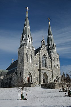
St. Thomas of Villanova Church in Villanova is known for its Gothic revival architecture. The church, built between 1883 and 1887, is considered to have been the tallest man-made structure between the Delaware River and Lancaster at the time of its construction. Today, the church is nearly entirely whitewashed on the interior and lit by blue stained glass windows. Much of the original decoration has been preserved, although moved to different locations in the parish and campus. The windows enclosing the nave depict the life of St. Augustine. [25]

St. David's Episcopal Church, whose graveyard, and buildings begun in 1715, is listed on the National Register of Historic Places. [26] [27] The grave yard hosts many founders including the celebrated revolutionary General “Mad” Anthony Wayne.

The Bridge in Radnor Township No.1, Bridge in Radnor Township No.2, Camp-Woods, Chanticleer, Downtown Wayne Historic District, Glenays, North Wayne Historic District, Pennsylvania Railroad Station at Wayne, Radnor Friends Meetinghouse, South Wayne Historic District, Wayne Hotel, and Woodcrest are listed on the National Register of Historic Places. [28]

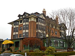
Other historic structures in Radnor Township include the Sorrel Horse, a former tavern located on Conestoga Road that sheltered George Washington and Lafayette during the Continental Army's retreat back to Philadelphia from the Battle of Brandywine. [29]

Economy

Lincoln Financial Group is headquartered in Radnor Township. [30] In 2007 the company moved 400 employees, including its top executives, to Radnor from Philadelphia. [31] Other companies based in Radnor Township include, J. G. Wentworth, TV Guide magazine , and Airgas.

Top employers

The main house at Chanticleer Garden Chanticleer Gardens Main House Springtime 2892px.jpg
The main house at Chanticleer Garden

According to Radnor Township's 2013 Comprehensive Annual Financial Report, [32] the top employers in the city are:

#Employer# of EmployeesCommunity
1 Villanova University 3,438 Villanova
2 Radnor Township School District 933 Wayne
3 Eastern University 841 St. Davids
4 Lincoln Financial 641 Radnor
5 VWR 448 Radnor
6 Janssen Biotech 403 Radnor
7 Penn Medicine Radnor 367 Radnor
8 Cabrini University 332 Radnor
9 Jefferson Health System 318 Radnor
10 J.G. Wentworth 279 Radnor

Education

Primary and secondary schools

Public schools

Pupils in Radnor Township attend Radnor Township School District. Radnor High School and Radnor Middle School are the sole public high and middle schools of the district. There are three elementary schools in the RTSD: Radnor Elementary School, Ithan Elementary School, and Wayne Elementary School.

Private schools

Archbishop John Carroll High School, a Roman Catholic High School in the Archdiocese of Philadelphia. Valley Forge Military Academy and College contains a boarding school program for seventh through twelfth grades. The Agnes Irwin School is an all-girls school for prekindergarten through twelfth grade. St. Katharine of Siena is a Catholic school in Wayne for students in kindergarten through eighth grade. The Hill Top Preparatory School is a school located in Ithan for students with learning disabilities in fifth through twelfth grade. Armenian Sisters Academy, an Armenian primary school, has a Radnor postal address but is located in Upper Merion Township. [33] [34] [35]

Colleges and universities

Villanova University, Eastern University, and Cabrini University are located within Radnor Township. Valley Forge Military Academy and College operates a two-year junior college.

Sports

Radnor Township is home to the Villanova Wildcats, the NCAA Division I athletic program of Villanova University, the Cabrini Cavaliers, the NCAA Division III athletic program of Cabrini University, and the Eastern Eagles, the NCAA Division III athletic program of Eastern University.

The Villanova Wildcats have a storied athletic program, the pinnacle of which being their men's basketball program. The Wildcats are consistently ranked among the AP Top 25, and won the NCAA Division I men's basketball tournament in 1985, 2016, and 2018. Each of these championships featured celebrations by students at the intersection of Lancaster and Ithan Avenues. [36]

The Cabrini Cavaliers won their first NCAA Division III Men's Lacrosse Championship in 2019, defeating the Amherst Mammoths by a score of 16–12. [37]

SchoolNicknameColorsAssociationConference
Villanova University Wildcats Blue and White NCAA Division I Big East
Cabrini University Cavaliers Blue and White NCAA Division III Atlantic East
Eastern University Eagles Maroon and White NCAA Division III MAC

Infrastructure

Transportation

Public transportation

Goshen Road Bridge GoshenRoadBridge.jpg
Goshen Road Bridge

Radnor Township is serviced by SEPTA Regional Rail's Paoli/Thorndale Line which has stations within the township at Wayne, St. Davids, Radnor, and Villanova. Eastern Radnor Township is served by SEPTA's Norristown High Speed Line, an interurban heavy rail line. Within Radnor Township, there are seven stations located at Bryn Mawr, Roberts Road, Garrett Hill, Stadium – Ithan Avenue, Villanova, Radnor, and County Line. [38]

SEPTA Suburban Bus Route 106 runs through the center of Radnor Township via Lancaster Avenue, excluding a brief deviation along King of Prussia and Radnor-Chester Roads to service the Norristown High Speed Line's Radnor Station and Paoli/Thorndale Line's Radnor Station. The 106 serves the communities of Rosemont, Villanova, St. Davids, Radnor, and Wayne with westbound access to Paoli and eastbound access to the 69th Street Transportation Center in Upper Darby. [38] [39] The 105 bus formerly drove a route similar to that of the 106, but a 2016 schedule change moved the route's western terminus to Rosemont Station, on Montrose Avenue near the border of Radnor Township and Lower Merion Township. Since 2017, the route runs parallel to Radnor Township's border on Airedale Road, but never enters the township.

Roads and highways

I-476 "Blue Route" northbound in Radnor Township 2022-10-08 15 11 34 View north along Interstate 476 (Mid-County Expressway-"Blue Route") from the overpass for the rail line between U.S. Route 30 (Lancaster Avenue) and County Line Road in Radnor Township, Delaware County, Pennsylvania.jpg
I-476 "Blue Route" northbound in Radnor Township

As of 2018, there were 118.96 miles (191.45 km) of public roads in Radnor Township, of which 33.59 miles (54.06 km) were maintained by Pennsylvania Department of Transportation (PennDOT) and 85.37 miles (137.39 km) were maintained by the township. [40]

Highways serving Radnor Township include U.S. Route 30, which passes east–west through the township on Lancaster Avenue (part of the historical Lincoln Highway), Pennsylvania Route 320, which passes north–south through the township along Sproul Road and Spring Mill Road; and Interstate 476, which passes north–south through the township on the Blue Route and has an interchange with US 30. [41]

Healthcare

The corporate offices of Main Line Health are located in the Radnor Financial Center, as is the Thomas Jefferson University Marcus Institute clinic. In 2020, Penn Medicine opened a hospital next to the Blue Route called Penn Medicine Radnor.

Notable people

Taps was filmed at Valley Forge Military Academy and College.

See also

Related Research Articles

<span class="mw-page-title-main">Bryn Mawr, Pennsylvania</span> Census-designated place in Pennsylvania, United States

Bryn Mawr, from Welsh for 'big hill', is a census-designated place (CDP) located across three townships: Radnor Township and Haverford Township in Delaware County and Lower Merion Township in Montgomery County, Pennsylvania, United States. It is located just west of Philadelphia along Lancaster Avenue, also known as U.S. Route 30.

<span class="mw-page-title-main">Delaware County, Pennsylvania</span> County in Pennsylvania, United States

Delaware County, colloquially referred to as Delco, is a county in the Commonwealth of Pennsylvania. With a population of 576,830 as of the 2020 census, it is the fifth-most populous county in Pennsylvania and the third-smallest in area. The county was created on September 26, 1789, from part of Chester County and named for the Delaware River.

<span class="mw-page-title-main">Easttown Township, Pennsylvania</span> Township in Pennsylvania, United States

Easttown Township is a township in Chester County, Pennsylvania, United States. The population was 10,984 at the 2020 census. The township, which lies in the western half of Philadelphia's Main Line suburbs, is comprised predominantly of parts of two unincorporated areas: Devon and Berwyn. A small portion of the township has a Paoli address.

<span class="mw-page-title-main">Haverford Township, Pennsylvania</span> Place in Pennsylvania

Haverford Township is a home rule municipality township in Delaware County, Pennsylvania, United States. Haverford is named after the town of Haverfordwest in Wales, United Kingdom. It is a commuting suburb located due west of Philadelphia and is officially known as the Township of Haverford. Despite being under a home rule charter since 1977, it continues to operate under a Board of Commissioners divided into wards, as do "First Class" townships that are still under the Pennsylvania Township Code. Haverford Township was founded in 1682 and incorporated in 1911.

<span class="mw-page-title-main">Newtown Township, Delaware County, Pennsylvania</span> Township in Pennsylvania, United States

Newtown Township, also referred to by the name of its post office of Newtown Square, is a township in Delaware County, Pennsylvania, United States. Prior to 1789, it was part of Chester County. As of the 2020 census, the population was 15,002.

<span class="mw-page-title-main">Lower Merion Township, Pennsylvania</span> Township in Pennsylvania, United States

Lower Merion Township is a township in Montgomery County, Pennsylvania. It is part of the Philadelphia Main Line. The township's name originates with the county of Merioneth in north Wales. Merioneth is an English-language transcription of the Welsh Meirionnydd.

<span class="mw-page-title-main">Narberth, Pennsylvania</span> Borough in Montgomery County, Pennsylvania

Narberth is a borough in Montgomery County, Pennsylvania. It is one of many neighborhoods on the historic Philadelphia Main Line. The population was 4,282 at the 2010 census.

<span class="mw-page-title-main">Upper Merion Township, Pennsylvania</span> Township in Pennsylvania, United States of America

Upper Merion Township is a township in Montgomery County, Pennsylvania. The population was 33,613 at the 2020 U.S. Census. Located 16 miles (26 km) from Philadelphia, it consists of the villages of Gulph Mills, King of Prussia, Swedeland, Swedesburg, and portions of Radnor, and Wayne.

<span class="mw-page-title-main">Philadelphia Main Line</span> Collection of suburban communities in Pennsylvania, United States

The Philadelphia Main Line, known simply as the Main Line, is an informally delineated historical and social region of suburban Philadelphia, Pennsylvania. Lying along the former Pennsylvania Railroad's once prestigious Main Line, it runs northwest from Center City Philadelphia parallel to Lancaster Avenue, also known as U.S. Route 30.

<span class="mw-page-title-main">Radnor, Pennsylvania</span> Locality on the Philadelphia Main Line

Radnor is a community which straddles Montgomery and Delaware Counties, Pennsylvania, United States. It is located approximately 13 miles west of Philadelphia, in the Main Line suburbs. The community was named after Radnor, in Wales.

<span class="mw-page-title-main">Wayne, Pennsylvania</span> Unincorporated community in Delaware County, Pennsylvania, United States

Wayne is an unincorporated community centered in Delaware County, Pennsylvania, United States, on the Main Line, a series of highly affluent Philadelphia suburbs located along the railroad tracks of the Pennsylvania Railroad and one of the wealthiest areas in the nation. While the center of Wayne is in Radnor Township, Wayne extends into both Tredyffrin Township in Chester County and Upper Merion Township in Montgomery County. The center of Wayne was designated the Downtown Wayne Historic District in 2012. Considering the large area served by the Wayne post office, the community may extend slightly into Easttown Township, Chester County, as well.

<span class="mw-page-title-main">Rosemont, Pennsylvania</span> Place in Pennsylvania, United States

Rosemont is a neighborhood and census-designated place that is located in Bryn Mawr, Pennsylvania, United States on the Philadelphia Main Line. Part of Lower Merion Township in Montgomery County, it is best known as the home of Rosemont College. It is the location of the 1894 gothic-revival Anglo-Catholic Church of the Good Shepherd.

<span class="mw-page-title-main">Wynnewood, Pennsylvania</span> Place in Pennsylvania, United States

Wynnewood is a suburban unincorporated community, located west of Philadelphia, straddling Lower Merion Township in Montgomery County, Pennsylvania and Haverford Township in Delaware County, Pennsylvania, United States.

<span class="mw-page-title-main">Villanova, Pennsylvania</span> Village in Pennsylvania

Villanova is a suburb of Philadelphia, Pennsylvania, United States. It straddles Lower Merion Township in Montgomery County and Radnor Township in Delaware County. It is located at the center of the Philadelphia Main Line, a series of Philadelphia suburbs located along the original east–west railroad tracks of the Pennsylvania Railroad. It is served by the SEPTA Paoli/Thorndale Line regional rail train and the Norristown High Speed Line.

<span class="mw-page-title-main">Villanova station (SEPTA Regional Rail)</span>

Villanova station is a SEPTA Regional Rail station on the campus of Villanova University in Villanova, Pennsylvania. It is in Radnor Township, located on North Spring Mill Road near County Line Road and serves most Paoli/Thorndale Line trains.

<span class="mw-page-title-main">St. Davids station</span> SEPTA rail station in Philadelphia

St. Davids station is a commuter rail station located in the western suburbs of Philadelphia at the intersection of Chamounix Road & Glynn Lane, Wayne, Pennsylvania. Named for the nearby historic Episcopal church, the station is served by most Paoli/Thorndale Line trains. There is no ticket office at this station. There are 107 parking spaces at the station. There are also 5 bike racks available that can accommodate up to 20 bikes. It is in Radnor Township.

<span class="mw-page-title-main">Wayne station</span>

Wayne station is a SEPTA Regional Rail station located in the western suburbs of Philadelphia in Wayne, Delaware County, Pennsylvania. It is served by most Paoli/Thorndale Line trains. It is in Radnor Township.

<span class="mw-page-title-main">Stadium–Ithan Avenue station</span> Rapid transit station in Pennsylvania

Stadium–Ithan Avenue station, formerly known as Stadium station, is a SEPTA rapid transit station in Radnor Township, Pennsylvania. It serves the Norristown High Speed Line and is located on Ithan Avenue near Lancaster Avenue, near Villanova Stadium, the athletic facility for nearby Villanova University. Local, Hughes Park Express, and Norristown Express trains stop at Ithan Avenue. The station lies 6.8 track miles (10.9 km) from 69th Street Terminal.

<span class="mw-page-title-main">St. David's Episcopal Church (Radnor, Pennsylvania)</span> Historic church in Pennsylvania, United States

St. David's Episcopal Church, also known as St. David's at Radnor or Old St. David's, is a parish of the Episcopal Church located at 763 South Valley Forge Road in Radnor Township, Pennsylvania. The church property contains the original church built in 1715, a chapel, church offices, school and cemetery. The property straddles the borders of Radnor Township and Newtown Township in Delaware County and the majority of the cemetery is in Easttown Township, Chester County. It was founded c. 1700 in the Welsh Tract section of the Province of Pennsylvania by Welsh settlers and has grown to be the largest congregation in the Episcopal Diocese of Pennsylvania with approximately 3,000 members. The original church and cemetery were placed on the National Register of Historic Places in 1978.

Ithan, formerly known as Radnorville, is a small village and neighborhood located in Villanova, Pennsylvania, west of Philadelphia. It is generally considered to include all portions of Villanova approximately a half mile either side of the Blue Route.

References

  1. Ilgenfritz, Richard. "William White named new Radnor Township manager". Main Line Times. Main Line Media News. Archived from the original on April 24, 2020. Retrieved April 23, 2020.
  2. "2016 U.S. Gazetteer Files". United States Census Bureau. Archived from the original on August 24, 2017. Retrieved August 13, 2017.
  3. 1 2 "QuickFacts: Radnor Township, Delaware County, Pennsylvania". Census Quick Facts. U.S. Census Bureau. Archived from the original on December 7, 2020. Retrieved November 27, 2020.
  4. "Archived copy". Archived from the original on September 2, 2017. Retrieved September 2, 2017.{{cite web}}: CS1 maint: archived copy as title (link)
  5. "Municipal Statistics". Pennsylvania Department of Community and Economic Development. Archived from the original on November 26, 2020. Retrieved November 27, 2020.
  6. Jordan, John Woolf (1914) (1914). A History of Delaware County, Pennsylvania, and Its People, Volume 1. Lewis Historical Publishing Company. p. 115. ISBN   9785876569028. Archived from the original on October 22, 2021. Retrieved December 1, 2020.{{cite book}}: CS1 maint: numeric names: authors list (link)
  7. 1 2 "Radnor Township History". Radnor Township. Archived from the original on October 31, 2020. Retrieved December 2, 2020.
  8. "Schools & Universities". Radnor Township. Archived from the original on December 6, 2020. Retrieved November 27, 2020.
  9. Ashmeade, Henry Graham (1884). History of Delaware County, Pennsylvania. Philadelphia: L.H. Everts & Co. p.  678 . Retrieved June 16, 2017.
  10. Espenshade, A. Howry (1925). Pennsylvania place names. State College, PA: The Pennsylvania State College. p. 246. Archived from the original on October 22, 2021. Retrieved June 8, 2016.
  11. "Toll Roads in the United States: History and Current Policy" (PDF). Federal Highway Administration. U.S. Department of Transportation. Archived (PDF) from the original on October 21, 2020. Retrieved November 27, 2020.
  12. "PRISM Climate Group, Oregon State U". prism.oregonstate.edu. Archived from the original on August 25, 2019. Retrieved September 11, 2019.
  13. "Census of Population and Housing". Census.gov. Archived from the original on October 3, 2014. Retrieved June 4, 2016.
  14. "Census 2020". Archived from the original on October 22, 2021. Retrieved October 7, 2021.
  15. "U.S. Census website". United States Census Bureau. Archived from the original on December 27, 1996. Retrieved January 31, 2008.
  16. "Religious composition of adults in Radnor Township, Pennsylvania". Religion. Sperling's Best Places. 2017. Archived from the original on November 16, 2020. Retrieved October 31, 2020.
  17. "Philadelphia's Irish Immigrant History". Great Hunger Event. Archived from the original on November 24, 2020. Retrieved November 27, 2020.
  18. "Aspects of Italian Immigration to Philadelphia". The Pennsylvania State University. Archived from the original on December 5, 2020. Retrieved November 27, 2020.
  19. "Learn More About Our Parish History". St. Thomas of Villanova Church. Archived from the original on December 5, 2020. Retrieved December 23, 2020.
  20. Sperling, Bert. "Religion in Radnor Township, PA". Sperling's BestPlaces. Archived from the original on November 16, 2020. Retrieved December 23, 2020.
  21. "Delaware County (Pennsylvania)". The Association of Religion Data Archives. The Pennsylvania State University. Archived from the original on December 6, 2020. Retrieved November 27, 2020.
  22. "Archdiocese of Philadelphia map". archphila.org. Archived from the original on December 13, 2020. Retrieved November 16, 2020.
  23. Allen, W. Frank. "About St. David's". St. David's Episcopal Church. Archived from the original on January 22, 2021. Retrieved December 23, 2020.
  24. "Radnor Township, Pennsylvania Data". Data Center. Modern Language Association. Archived from the original on March 8, 2016. Retrieved November 27, 2020.
  25. "St. Thomas of Villanova Church". The Art of Villanova University. Villanova University. Archived from the original on January 7, 2009. Retrieved November 27, 2020.
  26. "St. David's Church: Who We Are: History". Archived from the original on October 4, 2011.
  27. "Item No.:78002394 NRIS (National Register Information System)". National Park Service. Archived from the original on February 20, 2013. Retrieved September 26, 2008.
  28. "National Register Information System". National Register of Historic Places . National Park Service. July 9, 2010.
  29. The Agnes Irwin School lower school now uses this building. Pilgrim’s Hill is located along the modern Conestoga Rd in Garret Hill and was a first test for many early pioneers traveling west. "Fight Over An Old-Time Inn" Archived 2021-10-22 at the Wayback Machine , New York Times, Dec. 20, 1903
  30. "Radnor township, Pennsylvania [ permanent dead link ]." U.S. Census Bureau. Retrieved on August 20, 2009.
  31. Blumenthal, Jeff. "Lincoln sells Delaware Investments Archived 2009-09-06 at the Wayback Machine ." Philadelphia Business Journal . Wednesday August 19, 2009. Modified Thursday August 20, 2009. Retrieved on August 24, 2009.
  32. "Township of Radnor CAFR" (PDF). Archived from the original (PDF) on December 31, 2014.
  33. "Home". Armenian Sisters Academy. Archived from the original on September 1, 2019. Retrieved September 1, 2019. 440 Upper Gulph Road | Radnor, PA 19087
  34. "Township Zoning Map". Upper Merion Township, Pennsylvania. Archived from the original on October 22, 2021. Retrieved September 1, 2019. – Also see: Township Street Map Archived 2019-09-01 at the Wayback Machine
  35. Panosian, Sevana (July 4, 2019). "The Battle Cry for Armenian Schools in the Diaspora". Armenian Weekly . Archived from the original on September 1, 2019. Retrieved September 1, 2019. (Opinion article) – The article describes it as being in Radnor Township, but an analysis of maps shows that it is in Upper Merion.
  36. "Classes canceled at Villanova after championship victory". 6abc Philadelphia. April 3, 2018. Archived from the original on April 6, 2018. Retrieved April 3, 2018.
  37. Sigal, Jonathan. "CABRINI CAPS HISTORIC SEASON WITH FIRST DIVISION III NATIONAL TITLE". US Lacrosse Magazine. Archived from the original on December 5, 2020. Retrieved May 26, 2020.
  38. 1 2 SEPTA Official Transit & Street Map Suburban (PDF) (Map). SEPTA. Archived (PDF) from the original on April 7, 2016. Retrieved May 2, 2016.
  39. "106 Map" (PDF). Archived (PDF) from the original on December 15, 2017. Retrieved November 27, 2017.
  40. "Radnor Township map" (PDF). PennDOT. Retrieved March 12, 2023.
  41. Delaware County, Pennsylvania Highway Map (PDF) (Map). PennDOT. 2015. Archived (PDF) from the original on October 16, 2015. Retrieved January 25, 2016.
  42. 1 2 3 4 "Radnor High School Hall of Fame". Archived from the original on August 4, 2020. Retrieved April 30, 2020.