Upper Chichester Township, Pennsylvania

Last updated

Upper Chichester Township, Pennsylvania
Chichester Meeting 2.jpg
Delaware County Pennsylvania incorporated and unincorporated areas Upper Chichester highlighted.svg
Location in Delaware County and the state of Pennsylvania.
Pennsylvania in United States (US48).svg
Location of Pennsylvania in the United States
Coordinates: 39°50′18″N75°26′26″W / 39.83833°N 75.44056°W / 39.83833; -75.44056
CountryUnited States
StatePennsylvania
County Delaware
Area
[1]
  Total6.70 sq mi (17.34 km2)
  Land6.69 sq mi (17.32 km2)
  Water0.01 sq mi (0.02 km2)
Elevation
98 ft (30 m)
Population
 (2010)
  Total16,738
  Estimate 
(2016) [2]
16,992
  Density2,540.67/sq mi (980.99/km2)
Time zone UTC-5 (EST)
  Summer (DST) UTC-4 (EDT)
ZIP code
19061
Area code 610
FIPS code 42-045-78776
Communities Boothwyn
Ogden
Twin Oaks
Website www.upperchichester.org

Upper Chichester Township is a civil township in Delaware County, Pennsylvania, United States. The population was 16,738 at the 2010 census. [3]

Contents

History

The Lenni Lenape Indians were the earliest occupants of Upper Chichester. They erected several semi-permanent villages in the area tied to fishing and hunting cycles with some farming.

The Upper Chichester area was claimed by New Sweden in 1643 and the Dutch in 1654, but both nations were primary interested in trading with the Lenni Lenape Indians.

The first European settlers to Upper Chichester were in 1681 under the Penn's Grant of land to William Penn from King Charles II. The first purchasers under Penn's authority were fourteen English and Welshmen, mostly Quakers.

Upper Chichester Township was originally part of the section of Chester County called Chichester. Chichester comprised the area now known as Upper and Lower Chichester. It is named after the town Chichester in West Sussex, England from which many of its settlers came from. [4]

Upper Chichester Township, at the time called "Chichester Liberty," is considered by most to be one of the first settlements within the land grant of Pennsylvania.

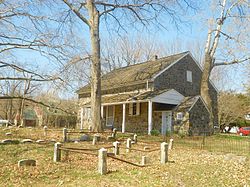
Among the earliest settlers of the township was Walter Martin, the founder of St. Martin's Church, in the late 17th century. [5] The road from Chichester to Aston traversing the township almost due north, was laid out 1688, while the Upper Chichester road was laid out on October 25, 1687. At the southwestern limit of the territory was a tract of 250 acres (100 ha), which was located September 5 and 6, 1681. The "Twelve-Mile Circle" (the circular northern boundary line of the state of Delaware) traverses this tract.

The division of Chichester into Upper and Lower Chichester was made early in 1700 to facilitate public business. In 1753, an effort was made to have the division officially recognized. The movement was, however, met by sturdy opposition from the leading citizens and land-owners of Lower Chichester, stating that the township as it currently stood was convenient enough and did not need any separation. They further argued that recent work to mend the highways in Lower Chichester, and the need to provide for several poor in the township were more important uses of funds than the cost of the survey.

The matter was permitted to drag along for six years, during which time the reasons for the official recognition of the separation of the two townships became apparent to all. In August 1759, a petition to formally separate the two townships was presented, bearing the signatures of almost every freeholder in Upper and Lower Chichester as well as those in Nether Providence. [6]

Edwin Booth, a significant land owner within Upper Chichester Township, is the namesake for the town of Boothwyn within Upper Chichester Township Boundaries. Local Pennsylvania Amish market "Booth's Corner" also inherit's his name and rests on the upper left corner of Booth's former land holdings.

Upper Chichester became a first class township on December 30, 1941. [7]

The Chichester Friends Meetinghouse is listed on the National Register of Historic Places.

Geography

Upper Chichester Township is in southwestern Delaware County, west of the city of Chester. It is bordered to the south by the state of Delaware, to the west by Bethel Township, to the north by Aston Township, to the east by Chester Township and the city of Chester, and to the south by the borough of Trainer and Lower Chichester Township. The unincorporated community of Boothwyn is in the center and southern part of the township.

According to the United States Census Bureau, the township has a total area of 6.70 square miles (17.34 km2), of which 6.69 square miles (17.32 km2) is land and 0.01 square miles (0.03 km2), or 0.15%, is water. [3]

Waterways in Upper Chichester include Naaman's Creek and Marcus Hook Creek.

Educational system

Upper Chichester is a part of Chichester School District. Children within the township usually attend Boothwyn Elementary School (Grades K-4) or Hilltop Elementary School (Grades K-4), Chichester Middle School (Grades 5-8), or Chichester High School (Grades 9-12).

Demographics

Historical population
CensusPop.Note
1930 3,743
1940 5,28041.1%
1950 6,99732.5%
1960 9,68238.4%
1970 11,41417.9%
1980 14,37726.0%
1990 15,0444.6%
2000 16,84212.0%
2010 16,738−0.6%
2020 16,8981.0%
U.S. Decennial Census [8] [9]

As of Census 2010, the racial makeup of the township was 84.0% White, 10.7% African American, 0.3% Native American, 2.7% Asian, 0.5% from other races, and 1.8% from two or more races. Hispanic or Latino of any race were 2.4% of the population [ dead link ].

As of the census [10] of 2000, there were 16,842 people, 6,500 households, and 4,439 families residing in the township. The population density was 2,508.2 inhabitants per square mile (968.4/km2). There were 6,705 housing units at an average density of 998.5 per square mile (385.5/km2). The racial makeup of the township was 86.00% White, 10.36% African American, 0.18% Native American, 2.02% Asian, 0.01% Pacific Islander, 0.30% from other races, and 1.14% from two or more races. Hispanic or Latino of any race were 1.16% of the population.

There were 6,500 households, out of which 30.3% had children under the age of 18 living with them, 52.9% were married couples living together, 11.2% had a female householder with no husband present, and 31.7% were non-families. 26.0% of all households were made up of individuals, and 10.9% had someone living alone who was 65 years of age or older. The average household size was 2.58 and the average family size was 3.15.

In the township the population was spread out, with 23.6% under the age of 18, 8.0% from 18 to 24, 32.6% from 25 to 44, 22.9% from 45 to 64, and 12.9% who were 65 years of age or older. The median age was 37 years. For every 100 females, there were 90.9 males. For every 100 females age 18 and over, there were 88.2 males.

The median income for a household in the township was $53,962, and the median income for a family was $63,125. Males had a median income of $43,159 versus $31,349 for females. The per capita income for the township was $23,412. About 4.2% of families and 5.5% of the population were below the poverty line, including 8.1% of those under age 18 and 7.8% of those age 65 or over.

Transportation

I-95 southbound in Upper Chichester Township 2022-10-07 10 48 36 View south along Interstate 95 (Delaware Expressway) from the overpass for Chichester Avenue in Upper Chichester Township, Delaware County, Pennsylvania.jpg
I-95 southbound in Upper Chichester Township

As of 2020, there were 67.53 miles (108.68 km) of public roads in Upper Chichester Township, of which 20.81 miles (33.49 km) were maintained by Pennsylvania Department of Transportation (PennDOT) and 46.72 miles (75.19 km) were maintained by the township. [11]

Interstate 95 is the main highway serving Upper Chichester Township. It follows the Delaware Expressway along a southwest-to-northeast alignment through the southeastern section of the township. U.S. Route 322 interchanges with I-95 at the township's eastern border and heads northwestward along Conchester Highway through northern portions of the township. Pennsylvania Route 452 follows Market Street along a north-south alignment through eastern portions of the township. Finally, Pennsylvania Route 491 follows Naamans Creek Road along a northwest-southeast alignment across southwestern portions of the township.

Notable people

Related Research Articles

<span class="mw-page-title-main">Delaware County, Pennsylvania</span> County in Pennsylvania, United States

Delaware County, colloquially referred to as Delco, is a county in the Commonwealth of Pennsylvania. With a population of 576,830 as of the 2020 census, it is the fifth-most populous county in Pennsylvania and the third-smallest in area. The county was created on September 26, 1789, from part of Chester County and named for the Delaware River.

<span class="mw-page-title-main">Lower Oxford Township, Chester County, Pennsylvania</span> Township in Pennsylvania, United States

Lower Oxford Township is a township in Chester County, Pennsylvania, United States. The population was 5,420 at the 2020 census. Lincoln University, a historically black university, is located in the township.

<span class="mw-page-title-main">Newlin Township, Chester County, Pennsylvania</span> Township in Pennsylvania, United States

Newlin Township is a township in Chester County, Pennsylvania, United States. The population was 1,285 at the 2010 census.

<span class="mw-page-title-main">Upper Uwchlan Township, Pennsylvania</span> Township in Pennsylvania, United States

Upper Uwchlan Township is a township in Chester County, Pennsylvania, United States. The population was 11,227 at the 2010 census. The township included the community of Milford Mills before it was inundated by the creation of the Marsh Creek Dam in 1972.

<span class="mw-page-title-main">Aston Township, Pennsylvania</span> Township in Pennsylvania, United States

Aston Township is a township in Delaware County, Pennsylvania, United States. The population was 16,592 at the 2010 census.

<span class="mw-page-title-main">Boothwyn, Pennsylvania</span> Census-designated place in Pennsylvania, United States

Boothwyn is a census-designated place (CDP) in Delaware County, Pennsylvania, United States. The population was 4,933 at the 2010 census, down from 5,206 at the 2000 census. The census estimation for population circa 2019 is 6,115.

<span class="mw-page-title-main">Broomall, Pennsylvania</span> Census-designated place in Pennsylvania, United States

Broomall is a census-designated place (CDP) in Marple Township, Delaware County, Pennsylvania, United States. The population was 10,789 at the 2010 census.

<span class="mw-page-title-main">Edgmont Township, Delaware County, Pennsylvania</span> Township in Pennsylvania, United States

Edgmont Township is a township in Delaware County, Pennsylvania, United States. Edgmont contains the unincorporated community of Gradyville. The population was 3,987 at the 2010 census.

<span class="mw-page-title-main">Linwood, Pennsylvania</span> Census-designated place in Pennsylvania, United States

Linwood is a census-designated place (CDP) in Delaware County, Pennsylvania, United States. The population was 3,281 at the 2010 census.

<span class="mw-page-title-main">Lower Chichester Township, Delaware County, Pennsylvania</span> Township in Pennsylvania, United States

Lower Chichester Township is a township in Delaware County, Pennsylvania, United States. The population was 3,469 at the 2010 census. It contains the census designated place of Linwood.

<span class="mw-page-title-main">Marcus Hook, Pennsylvania</span> Borough in Pennsylvania, United States

Marcus Hook is a borough in Delaware County, Pennsylvania, United States. The population was 2,397 at the 2010 census. The current mayor is Gene Taylor. The borough calls itself "The Cornerstone of Pennsylvania". The 2005 film One Last Thing... was set and partially filmed in Marcus Hook.

<span class="mw-page-title-main">Marple Township, Delaware County, Pennsylvania</span> Township in Pennsylvania, United States

Marple Township is a township in Delaware County, Pennsylvania, United States. It contains the census designated place of Broomall. The population was estimated at 23,743 as of 2015. ZIP codes include mainly 19008, as well as 19064 and 19063. The township is run by Marple Township board of commissioners.

<span class="mw-page-title-main">Middletown Township, Delaware County, Pennsylvania</span> Home rule municipality in Pennsylvania, United States

Middletown Township is a township in Delaware County, Pennsylvania, United States. The population was 15,807 at the 2010 census. The Pennsylvania State University has an undergraduate satellite campus called Penn State Brandywine located in the north-central portion of the township. Located outside of Philadelphia, it constitutes part of the Delaware Valley.

<span class="mw-page-title-main">Thornbury Township, Delaware County, Pennsylvania</span> Township in Pennsylvania, United States

Thornbury Township is a township in Delaware County, Pennsylvania, United States. As of the 2010 U.S. census, the population was 8,028, up from 7,093 at the 2000 census. It is adjacent to, and was once joined with, Thornbury Township in Chester County. It includes part of the census designated place of Cheyney University.

<span class="mw-page-title-main">Trainer, Pennsylvania</span> Borough in Pennsylvania, United States

Trainer is a borough in Delaware County, Pennsylvania, United States. The population was 1,828 at the 2010 census, down from 1,901 at the 2000 census. The borough was named after David Trainer, a wealthy textile manufacturer.

<span class="mw-page-title-main">Lower Nazareth Township, Northampton County, Pennsylvania</span> Place in Pennsylvania, United States

Lower Nazareth Township is a township in Northampton County, Pennsylvania. The population of Lower Nazareth Township was 5,674 at the 2010 census. The township is located in the Lehigh Valley, which had a population of 861,899 and was the 68th-most populous metropolitan area in the U.S. as of the 2020 census.

<span class="mw-page-title-main">Plainfield Township, Pennsylvania</span> Place in Pennsylvania, United States

Plainfield Township is a township in Northampton County, Pennsylvania. The population of Plainfield Township was 6,138 at the 2010 census. The township is part of the Lehigh Valley metropolitan area, which had a population of 861,899 and was the 68th-most populous metropolitan area in the U.S. as of the 2020 census.

<span class="mw-page-title-main">Upper Mount Bethel Township, Pennsylvania</span> Place in Pennsylvania, United States

Upper Mount Bethel Township is a township in Northampton County, Pennsylvania. The population of Upper Mount Bethel Township was 6,706 at the 2010 census. The township is part of the Lehigh Valley metropolitan area, which had a population of 861,899 and was the 68th-most populous metropolitan area in the U.S. as of the 2020 census.

<span class="mw-page-title-main">Chester Township, Delaware County, Pennsylvania</span> Home rule municipality in Pennsylvania, United States

Chester Township is a township in Delaware County, Pennsylvania, United States. The population was 3,940 at the 2010 census, down from 4,604 at the 2000 census.

<span class="mw-page-title-main">Upper Providence Township, Delaware County, Pennsylvania</span> Home rule municipality in Pennsylvania, United States

Upper Providence Township is a township in Delaware County, Pennsylvania, United States, located around and to the north of the borough of Media, and approximately 15 miles (24 km) west of center city Philadelphia. The population was 10,142 at the 2010 census. The township lies between Ridley Creek on the west and Crum Creek on the east. Most of Ridley Creek State Park is in the township, towards the northern edge. Zoning is 98% residential, 1% commercial and 1% industrial, with minimal space zoned to commercial business.

References

  1. "2016 U.S. Gazetteer Files". United States Census Bureau. Retrieved August 13, 2017.
  2. "Population and Housing Unit Estimates" . Retrieved June 9, 2017.
  3. 1 2 "Geographic Identifiers: 2010 Demographic Profile Data (G001): Upper Chichester township, Delaware County, Pennsylvania". U.S. Census Bureau, American Factfinder. Archived from the original on February 13, 2020. Retrieved December 30, 2015.
  4. "Delaware County Historic Resources Survey - Report and Findings for Upper Chichester Township" (PDF). www.chichesterhistory.org. Retrieved November 25, 2017.
  5. "St. Martins Church". www.chichesterhistory.org. Retrieved December 8, 2017.
  6. Ashmeade, Henry Graham (1884). History of Delaware County, Pennsylvania. Philadelphia: L.H. Everts & Co. pp.  448–453. Retrieved May 29, 2017.
  7. "Delaware County Historic Resources Survey - Report and Findings for Upper Chichester Township" (PDF). www.chichesterhistory.org. Retrieved November 25, 2017.
  8. "Census of Population and Housing". Census.gov. Retrieved June 4, 2016.
  9. "Census 2020".
  10. "U.S. Census website". United States Census Bureau . Retrieved January 31, 2008.
  11. "Upper Chichester Township map" (PDF). PennDOT. Retrieved March 12, 2023.