Marple Township, Pennsylvania

Last updated
Marple Township
MasseyHouse.JPG
Seventeenth-century Thomas Massey House on Lawrence Road
Marple Township Logo.jpg
Delaware County Pennsylvania incorporated and unincorporated areas Marple highlighted.svg
Location in Delaware County and the state of Pennsylvania
Pennsylvania in United States (US48).svg
Location of Pennsylvania in the United States
Coordinates: 39°58′30″N75°21′29″W / 39.97500°N 75.35806°W / 39.97500; -75.35806
CountryUnited States
StatePennsylvania
County Delaware
Area
[1]
  Total10.52 sq mi (27.24 km2)
  Land10.20 sq mi (26.42 km2)
  Water0.31 sq mi (0.81 km2)
Elevation
361 ft (110 m)
Population
 (2010)
  Total23,428
  Estimate 
(2016) [2]
23,780
  Density2,330.92/sq mi (899.96/km2)
Time zone UTC-5 (EST)
  Summer (DST) UTC-4 (EDT)
ZIP codes
19008, 19063, 19064
Area code 610
FIPS code 42-045-47616
Website www.marpletwp.com

Marple Township is a township in Delaware County, Pennsylvania, United States. It contains the census designated place of Broomall. The population was estimated at 23,743 as of 2015. ZIP codes include mainly 19008, as well as 19064 and 19063. The township is run by Marple Township board of commissioners.

Contents

History

Portion of 1687 Holme map. Marple Township is on the right side of the map, below Newtown and above Springfield. 1687HolmeMapProvRoad.jpg
Portion of 1687 Holme map. Marple Township is on the right side of the map, below Newtown and above Springfield.

The Delaware County area was first settled by Quakers who came to Pennsylvania by the Delaware River on September 29, 1683. The ship they used was called the Endeavor. [3] Marple Township was originally settled in 1684 and was recognized as a township in the same year. [4] The original spelling of the township was Marpool, but the spelling was changed to Marple in the Thomas Holme map of 1687. The Marpool spelling may have been an error. [5]

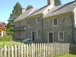
One of the settlers who arrived on the Endeavor was Thomas Massey. He obtained a 300-acre plantation in the township from William Penn. The house he built on the land is still preserved today, as well as some of its surrounding gardens. Another historical family known as the Van Leers built several historical sites and lived in the area. Dr. Bernardhus Van Leer owned the nearby Van Leer House and his family built the nearby Van Leer Cabin.

In 1948 Marple Township got its first police station. Before, there was no local branch, no patrols of the police, and only a county sheriff. Crimes were mostly settled between victims and perpetrators themselves. [6]

Marple became a first-class township in 1961.

Geography

According to the United States Census Bureau, the township has a total area of 10.5 square miles (27.2 km2), of which 10.2 square miles (26.4 km2) is land and 0.3 square mile (0.8 km2; 2.95%) is water.

The community of Broomall is located in, but is not coterminous with, Marple Township—the township also includes part of the ZIP codes of Springfield and Media. Other villages include Larchmont (also in Newtown Township) and Lawrence Park.

Waterways in Marple Township include Crum Creek, Darby Creek, Hotland Run, Springton Lake and Trout Run.

Marple Presbyterian Church, built 1834-1835, oldest church in the township Marple Presby DelCo PA.jpg
Marple Presbyterian Church, built 1834–1835, oldest church in the township

Adjacent municipalities

Climate

Marple Township straddles the boundary between a hot-summer humid continental climate (Dfa) and a humid subtropical climate (Cfa). The average monthly temperature in Broomall ranges from 31.9 °F in January to 77.1 °F in July. The hardiness zone is 7a and the annual average absolute minimum temperature in Broomall is 1.9 °F.

Demographics

As of the census [7] of 2010, there were 23,428 people, down slightly from 23,737 people in 2000. The racial makeup of the township was 89.6% White, 2.1% African American, 0.1% Native American, 7.0% Asian, 0.3% from other races, and 0.9% from two or more races. Hispanic or Latino people of any race were 1.3% of the population. [8]

The 2000 census showed 8,623 households, and 6,415 families residing in the township. The population density was 2,326.1 inhabitants per square mile (898.1/km2). There were 8,797 housing units at an average density of 862.1 per square mile (332.9/km2). The racial makeup of the township was 92.60% White, 1.10% African American, 0.09% Native American, 5.51% Asian, 0.12% from other races, and 0.59% from two or more races. Hispanic or Latino people of any race were 0.66% of the population.

Historical population
CensusPop.Note
1930 1,553
1940 2,17039.7%
1950 4,779120.2%
1960 19,722312.7%
1970 25,04027.0%
1980 23,642−5.6%
1990 23,123−2.2%
2000 23,7372.7%
2010 23,428−1.3%
2020 24,2143.4%
[9] [10]

There were 8,623 households, out of which 30.0% had children under the age of 18 living with them, 64.1% were married couples living together, 7.6% had a female householder with no husband present, and 25.6% were non-families. 22.6% of all households were made up of individuals, and 13.0% had someone living alone who was 65 years of age or older. The average household size was 2.64 and the average family size was 3.12.

In the township the population was spread out, with 21.8% under the age of 18, 6.3% from 18 to 24, 24.8% from 25 to 44, 25.0% from 45 to 64, and 22.0% who were 65 years of age or older. The median age was 43 years. For every 100 females, there were 89.4 males. For every 100 females age 18 and over, there were 85.1 males.

The median income for a household in the township was $59,577, and the median income for a family was $71,829. Males had a median income of $47,062 versus $32,304 for females. The per capita income for the township was $28,494. About 2.1% of families and 4.6% of the population were below the poverty line, including 3.7% of those under age 18 and 5.0% of those age 65 or over.

Government

Marple Township is governed by a Board of Commissioners made up of representatives from each of the township's wards which meets for regular sessions. The current[ when? ] commissioners, by ward, are Joseph Rufo (R-1), Jan Ceton (R-2), Robert Fortebouno (R-3), John Lucas (R-4), John Longacre (R-5), Michael Molinaro (R-6), and Daniel Leefson (R-7). Rufo currently serves as the board's president.

Politics

Presidential elections results
Year Republican Democratic
2012 53.5%7,01045.8% 6,008
2008 51.1%6,92048.0% 6,503

Marple generally leans to the right on the political spectrum. In the 2008 general elections, the township voted Republican for every office except for the General Assembly representative from the 166th district.

Along with Aston, Bethel, Chadds Ford, Concord, Edgmont, Middletown, Newtown, Springfield, and Tinicum, Marple was one of the ten Delaware County municipalities to vote Republican in the 2008 presidential election. The county as a whole voted Democratic. [11]

Education

Lewis Tannery was used as a safe house on the Underground Railroad. Lewis Tannery Marple DelCo PA.jpg
Lewis Tannery was used as a safe house on the Underground Railroad.

Marple Township lies within the Marple Newtown School District. The district has four elementary schools, one middle school, and one high school.

Delaware County Community College, a public, two-year community college, is also located in Marple Township; this campus has a Media mailing address. [12]

The township is also served by the Marple Public Library.

St. Luke Greek Orthodox Church on N. Malin Road St Lukes Orthodox Marple Township Delco PA.jpg
St. Luke Greek Orthodox Church on N. Malin Road

Parks

Marple Township has a system of eleven parks. [13] They are maintained by the municipal government.

Transportation

I-476 "Blue Route" southbound in Marple Township 2022-10-07 14 31 02 View south along Interstate 476 (Mid-County Expressway-"Blue Route") from the overpass for Pennsylvania State Route 320 (Sproul Road) in Marple Township, Delaware County, Pennsylvania.jpg
I-476 "Blue Route" southbound in Marple Township

As of 2021, there were 106.26 miles (171.01 km) of public roads in Marple Township, of which 25.81 miles (41.54 km) were maintained by Pennsylvania Department of Transportation (PennDOT) and 80.45 miles (129.47 km) were maintained by the township. [14]

Roads serving Marple Township include U.S. Route 1, which passes north–south through the southern part of the township along a freeway; Pennsylvania Route 3, which passes east–west through the northern part of the township along West Chester Pike; Pennsylvania Route 252, which passes north–south through the western part of the township along Newtown Street Road; Pennsylvania Route 320, which passes north–south through the township along Sproul Road; and Interstate 476, which passes north–south through the eastern part of the township along the Blue Route and has interchanges with US 1 and PA 3. [15]

SEPTA provides Suburban Bus service to Marple Township along Route 104, which follows West Chester Pike through the township on its route between West Chester and 69th Street Transportation Center in Upper Darby; Route 107, which runs from the Lawrence Park Shopping Center in the township to 69th Street Transportation Center via the Springfield Mall; Route 112, which follows Media Line Road and West Chester Pike through the township on its route between Delaware County Community College and the 69th Street Transportation Center; Route 115, which offers weekday service along Media Line Road and West Chester Pike through the township on its route between Delaware Community College and the Darby Transportation Center in Darby and the Philadelphia International Airport; Route 118, which follows Newtown Street Road through the township on its route between Newtown Square and the Chester Transportation Center in Chester; Route 120, which follows West Chester Pike through the township on its route between Cheyney University and the 69th Street Transportation Center; and Route 126, which runs from the Lawrence Park Shopping Center in the township to 69th Street Transportation Center via Havertown. [16]

Notable people

Related Research Articles

<span class="mw-page-title-main">Delaware County, Pennsylvania</span> County in Pennsylvania, United States

Delaware County, colloquially referred to as Delco, is a county in the Commonwealth of Pennsylvania. With a population of 576,830 as of the 2020 census, it is the fifth-most populous county in Pennsylvania and the third-smallest in area. The county was created on September 26, 1789, from part of Chester County and named for the Delaware River.

<span class="mw-page-title-main">Northampton Township, Bucks County, Pennsylvania</span> Township in Pennsylvania, United States

Northampton Township is a township in Bucks County, Pennsylvania, United States. The township is located approximately 12 miles northeast of Philadelphia. The population was 39,915 at the 2020 census.

<span class="mw-page-title-main">Easttown Township, Pennsylvania</span> Township in Pennsylvania, United States

Easttown Township is a township in Chester County, Pennsylvania, United States. The population was 10,984 at the 2020 census. The township, which lies in the western half of Philadelphia's Main Line suburbs, is comprised predominantly of parts of two unincorporated areas: Devon and Berwyn. A small portion of the township has a Paoli address.

<span class="mw-page-title-main">West Chester, Pennsylvania</span> Borough in Pennsylvania, United States

West Chester is a borough and the county seat of Chester County, Pennsylvania, United States. Located within the Philadelphia metropolitan area, the borough had a population of 18,461 at the 2010 census. West Chester is the mailing address for most of its neighboring townships. When calculated by mailing address, the population as of the 2010 U.S. Census was 108,696, which would make it the 10th largest city by mailing address in the state of Pennsylvania.

<span class="mw-page-title-main">West Goshen Township, Pennsylvania</span> Township in Pennsylvania, United States

West Goshen Township is a township in Chester County, Pennsylvania, United States. The population was 23,040 at the 2020 census. In 2013, Money Magazine voted West Goshen as the 10th best place to live in America. West Goshen has also been ranked in the top 15 places to live in America from 2014 to 2017 and is also at the top of best neighborhoods to raise a family in Pennsylvania every year.

<span class="mw-page-title-main">Broomall, Pennsylvania</span> Census-designated place in Pennsylvania, United States

Broomall is a census-designated place (CDP) in Marple Township, Delaware County, Pennsylvania, United States. The population was 10,789 at the 2010 census.

<span class="mw-page-title-main">Edgmont Township, Pennsylvania</span> Township in Pennsylvania, United States

Edgmont Township is a township in Delaware County, Pennsylvania, United States. Edgmont contains the unincorporated community of Gradyville. The population was 3,987 at the 2010 census.

<span class="mw-page-title-main">Middletown Township, Delaware County, Pennsylvania</span> Home rule municipality in Pennsylvania, United States

Middletown Township is a township in Delaware County, Pennsylvania, United States. The population was 15,807 at the 2010 census. The Pennsylvania State University has an undergraduate satellite campus called Penn State Brandywine located in the north-central portion of the township. Located outside of Philadelphia, it constitutes part of the Delaware Valley.

<span class="mw-page-title-main">Newtown Township, Delaware County, Pennsylvania</span> Township in Pennsylvania, United States

Newtown Township, also referred to by the name of its post office of Newtown Square, is a township in Delaware County, Pennsylvania, United States. Prior to 1789, it was part of Chester County. As of the 2020 census, the population was 15,002.

<span class="mw-page-title-main">Norwood, Pennsylvania</span> Borough in Pennsylvania, United States

Norwood is a borough that is located in Delaware County, Pennsylvania, United States. The population was 5,890 at the time of the 2010 census.

<span class="mw-page-title-main">Ridley Township, Pennsylvania</span> Township in Pennsylvania, United States

Ridley Township is a township in Delaware County, Pennsylvania, United States. The population was 30,768 at the 2010 census. Ridley Township contains the (CDPs) of Folsom and Woodlyn, along with the unincorporated communities of Crum Lynne and Holmes and a portion of Secane.

<span class="mw-page-title-main">Springfield Township, Delaware County, Pennsylvania</span> Township in Pennsylvania, United States

Springfield Township, or simply Springfield, is a township in Delaware County in the U.S. state of Pennsylvania. The population was 25,070 at the 2020 census. Springfield is a suburb of Philadelphia, located about 4 miles (6.4 km) west of the city.

<span class="mw-page-title-main">Upper Darby Township, Pennsylvania</span> Home rule township in Pennsylvania, United States

Upper Darby Township, often shortened to Upper Darby, is a home rule township in Delaware County, Pennsylvania, United States. As of the 2020 census, the township had a total population of 85,681, making it the state's sixth-most populated municipality after Philadelphia, Pittsburgh, Allentown, Reading, and Erie. Upper Darby borders Philadelphia, the nation's sixth-most populous city, and constitutes part of the Delaware Valley, also known as the Philadelphia metropolitan area, the nation's seventh-largest metropolitan area.

<span class="mw-page-title-main">Darby Township, Pennsylvania</span> First Class Township in Pennsylvania, United States

Darby Township is a township in Delaware County, Pennsylvania, United States. The population was 9,264 as of the 2010 census. It is home to both residential areas and expansive industrial districts. Darby Township is home to a diverse population and its industrial districts are popular among shipping companies for their proximity to Philadelphia International Airport. It also is known for being made up of two non-contiguous geographical areas, requiring one to pass through at least two neighboring municipalities to make it from one end of Darby Township to the other. Darby Township is a distinct municipality from the nearby and similarly named Darby Borough and Upper Darby Township.

<span class="mw-page-title-main">Nether Providence Township, Pennsylvania</span> Township in Pennsylvania, United States

Nether Providence Township is a first class township in Delaware County, Pennsylvania, United States. Many residents refer to the township by the name of its largest community, Wallingford, because the Wallingford postal code is used for most of the township. The population of the township was 13,706 at the 2010 census.

<span class="mw-page-title-main">Tinicum Township, Delaware County, Pennsylvania</span> Township in Pennsylvania, United States

Tinicum Township, also known as Tinicum Island or The Island, is a township in Delaware County, Pennsylvania, United States. The population was 4,091 at the 2010 census, down from 4,353 at the 2000 census. Included within the township's boundaries are the communities of Essington and Lester.

<span class="mw-page-title-main">SEPTA Routes 101 and 102</span> Light rail lines in Delaware County, Pennsylvania

SEPTA Routes 101 and 102, also known as the Media–Sharon Hill Line, are light rail lines operated by the Suburban Transit Division of the Southeastern Pennsylvania Transportation Authority, serving portions of Delaware County. The routes' eastern terminus is 69th Street Transportation Center in Upper Darby Township, Pennsylvania. Route 101 runs to Media, while Route 102 goes to Sharon Hill. Altogether, the two lines operate on approximately 11.9 miles (19.2 km) of route. The lines were formerly interurbans.

<span class="mw-page-title-main">Pennsylvania Route 3</span> State highway in Chester, Delaware, and Philadelphia counties in Pennsylvania, US

Pennsylvania Route 3 is a 24.3-mile (39.1 km) state highway located in the southeastern portion of Pennsylvania. The route runs from U.S. Route 322 Business in West Chester east to PA 611 in Philadelphia.

Route 104 is a bus route operated by SEPTA between Upper Darby's 69th Street Transportation Center and the North Campus of West Chester University in West Chester, Pennsylvania. Route 104 initially was a streetcar line which operated parallel to the West Chester Pike and was operated by the Philadelphia Suburban Transportation Company.

<span class="mw-page-title-main">Pennsylvania Route 252</span> State highway in Pennsylvania, US

Pennsylvania Route 252 is a north–south state highway in the U.S. state of Pennsylvania that connects PA 320 in Nether Providence Township at its southern terminus to PA 23 in Valley Forge at its northern terminus. The route runs through the western suburbs of Philadelphia in Delaware, Chester, and Montgomery counties, including Nether Providence Township, the borough of Media, Upper Providence Township, Marple Township, Newtown Township, Easttown Township, Tredyffrin Township, and Upper Merion Township. The route intersects many roads including U.S. Route 1 north of Media, PA 3 in Newtown Square, US 30 in Paoli, and US 202 near Berwyn.

References

  1. "2016 U.S. Gazetteer Files". United States Census Bureau. Retrieved Aug 13, 2017.
  2. "Population and Housing Unit Estimates" . Retrieved June 9, 2017.
  3. Neal, Aaron. "Thomas Massey House". ThomasMasseyHouse.org. Retrieved 19 March 2012.
  4. Lockhart, Keith. "Delaware County History". Delaware County (PA) History. Retrieved 19 March 2012.
  5. Ashmeade, Henry Graham (1884). History of Delaware County, Pennsylvania. Philadelphia: L.H. Everts & Co. p.  579 . Retrieved 9 June 2017.
  6. Marple Township Police Department: Brief Department History
  7. "U.S. Census website". United States Census Bureau . Retrieved 2008-01-31.
  8. "U.S. Census website". United States Census Bureau . Retrieved 2017-10-26.
  9. "DVRPC > Site Search". Archived from the original on 2019-04-09. Retrieved 2014-03-21.
  10. "Census 2020".
  11. "Official General Election Results".
  12. "Locations". Delaware County Community College . Retrieved 2023-10-29. Marple Campus Marple Township (Media mailing address)
  13. "Marple Township Park System". Archived from the original on 2011-09-18. Retrieved 2011-07-20.
  14. "Marple Township map" (PDF). PennDOT. Retrieved March 12, 2023.
  15. Delaware County, Pennsylvania Highway Map (PDF) (Map). PennDOT. 2015. Retrieved January 25, 2016.
  16. SEPTA Official Transit & Street Map Suburban (PDF) (Map). SEPTA. Retrieved May 2, 2016.