Tinicum Township, Delaware County, Pennsylvania

Last updated

Tinicum Township, Delaware County,
Pennsylvania
Lazaretto PA.JPG
The Philadelphia Lazaretto, November 2009
Delaware County Pennsylvania incorporated and unincorporated areas Tinicum highlighted.svg
Location in Delaware County and the U.S. state of Pennsylvania
Coordinates: 39°52′15″N75°16′57″W / 39.87083°N 75.28250°W / 39.87083; -75.28250
CountryUnited States
State Pennsylvania
County Delaware
Settled1643
Area
[1]
  Total8.78 sq mi (22.75 km2)
  Land5.75 sq mi (14.90 km2)
  Water3.03 sq mi (7.86 km2)
Elevation
13 ft (4 m)
Population
 (2010)
  Total4,091
  Estimate 
(2016) [2]
4,103
  Density713.44/sq mi (275.45/km2)
Time zone UTC-5 (EST)
  Summer (DST) UTC-4 (EDT)
ZIP Code
19029
Area code(s) 610 and 484
Website www.tinicumtownshipdelco.com

Tinicum Township, also known as Tinicum Island or The Island, is a township in Delaware County, Pennsylvania, United States. The population was 4,091 at the 2010 census, [3] down from 4,353 at the 2000 census. Included within the township's boundaries are the communities of Essington and Lester.

Contents

John Heinz National Wildlife Refuge at Tinicum is located in the township and attracts visitors year-round. Philadelphia International Airport's international terminal, the western end of the airfield, and runways 9L/27R and 9R/27L are also located in the township.

History

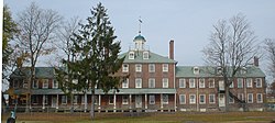
Tinicum Township has the distinction of being the site of the first recorded European settlement in Pennsylvania.[ citation needed ] Fort Nya Gothenborg, located on the South River, was settled by colonial Swedes in 1643. It served as capital of the New Sweden colony, under the rule of Royal Governor Johan Björnsson Printz. Governor Printz built his manor house, The Printzhof, on Tinicum Island, from which he administered the colony. The original Lenape called the place Tin-eek Unk. [4] The township is the site of the Philadelphia Lazaretto, the first quarantine hospital in the United States. [5] It and the Printzhof are listed on the National Register of Historic Places. [6]

Geography

Tinicum Township is located in southeastern Delaware County at 39°52′8″N75°17′17″W / 39.86889°N 75.28806°W / 39.86889; -75.28806 (39.868962, -75.288273). [7] It is bordered to the south by the Delaware River, to the west and northwest by Darby Creek, and to the northeast by the city of Philadelphia. The township borders the state of New Jersey at the center of the Delaware River. The unincorporated community of Essington is in the western part of the township, and Lester is directly to its east. The western part of Philadelphia International Airport takes up nearly all of the center and eastern parts of the township. The John Heinz National Wildlife Refuge lies along Darby Creek on the northwestern side of the township.

According to the U.S. Census Bureau, the township has a total area of 8.8 square miles (22.7 km2), of which 5.8 square miles (14.9 km2) is land and 3.0 square miles (7.8 km2), or 34.33%, is water. [3] It has a humid subtropical climate (Cfa) and average monthly temperatures in Essington range from 33.6 °F in January to 78.4 °F in July. The hardiness zone is mainly 7b with a little area of 7a and the average annual absolute minimum temperature in Essington is 5.2 °F. Archived July 4, 2019, at the Wayback Machine

Demographics

Historical population
CensusPop.Note
1930 3,630
1940 3,7924.5%
1950 5,31440.1%
1960 4,375−17.7%
1970 4,90612.1%
1980 4,291−12.5%
1990 4,4403.5%
2000 4,353−2.0%
2010 4,091−6.0%
2020 3,983−2.6%
[8]

As of 2010 census, the racial makeup of the township was 93.7% White, 1.7% African American, 0.2% Native American, 2.0% Asian, 0.4% from other races, and 1.9% from two or more races. Hispanic or Latino of any race were 2.2% of the population [ dead link ].

Economy

When Scott Paper Company was an independent company, it had its headquarters in International Plaza (Scott Plaza) in Tinicum Township. [9]

Education

Tinicum Township is part of the Interboro School District. [10] Tinicum Township is the district's only township, since the remaining municipalities having borough status. Tinicum School and Interboro High School (which is in Prospect Park) serve the township.

All-State Career School has two campuses in the Tinicum Township, in Lester and Essington. [11]

Transportation

I-95 southbound in Tinicum Township 2022-10-08 10 30 43 View south along Interstate 95 (Delaware Expressway) from the overpass for a ramp leading from northbound Interstate 95 to Philadelphia International Airport in Tinicum Township, Delaware County, Pennsylvania.jpg
I-95 southbound in Tinicum Township

As of 2018, there were 29.22 miles (47.03 km) of public roads in Tinicum Township, of which 10.00 miles (16.09 km) were maintained by Pennsylvania Department of Transportation (PennDOT) and 19.22 miles (30.93 km) were maintained by the township. [12]

Interstate 95 is the main highway serving Tinicum Township. It follows the Delaware Expressway along an east-west alignment through northwestern sections of the township. Pennsylvania Route 291 follows Industrial Highway parallel to and slightly south of I-95. Pennsylvania Route 420 begins at PA 291, heads north, interchanges with I-95, and exits the northwestern edge of the township.

Part of Philadelphia International Airport lies within Tinicum Township. [13]

SEPTA provides bus service to Tinicum Township along City Bus Route 37, which runs between the Chester Transportation Center and South Philadelphia via the Philadelphia International Airport, City Bus Route 68, which runs between the 69th Street Transportation Center and South Philadelphia, Suburban Bus Route 108, which runs between the 69th Street Transportation Center and the Philadelphia International Airport, and Suburban Bus Route 115, which runs between Delaware County Community College, the Darby Transportation Center, and the Philadelphia International Airport. [14]

Taxation

Employers who maintain worksites in Pennsylvania or employ individuals who may work from their homes are required to withhold applicable Earned Income Tax (EIT) from those employees. [15] This is a result of Act 32, which consolidated the tax collecting entities for the state of Pennsylvania. [16] The current Earned Income tax rate for Tinicum Township workers is 1.0%. [17] This tax must be withheld from employee pay and paid to the representative of the local tax collector, Keystone Collections Group. [18]

Birth of stromboli

The stromboli is reported by Peter Romano to have originated in 1950 in Tinicum Township at Romano's Italian Restaurant & Pizzeria, by his grandfather Nazzareno Romano. There, William Schofield supposedly gave it the name, after the movie Stromboli , starring Ingrid Bergman. [19] [20] Others claim that the stromboli was the brainchild of Mike Aquino Sr., and that he created it in Spokane, Washington, in 1954. [21]

Related Research Articles

<span class="mw-page-title-main">Plumstead Township, Pennsylvania</span> Township in Pennsylvania, United States

Plumstead Township is a township in Bucks County, Pennsylvania, United States. The population was 12,442 at the 2010 census.

<span class="mw-page-title-main">Edgmont Township, Pennsylvania</span> Township in Pennsylvania, United States

Edgmont Township is a township in Delaware County, Pennsylvania, United States. Edgmont contains the unincorporated community of Gradyville. The population was 3,987 at the 2010 census.

<span class="mw-page-title-main">Folcroft, Pennsylvania</span> Borough in Pennsylvania, United States

Folcroft is a borough in Delaware County, Pennsylvania, United States. The population was 6,606 at the 2010 census, down from 6,978 at the 2000 census.

<span class="mw-page-title-main">Glenolden, Pennsylvania</span> Borough in Pennsylvania, United States

Glenolden is a borough in Delaware County, Pennsylvania, United States. The population was 7,153 at the 2010 census, down from 7,476 at the 2000 census.

<span class="mw-page-title-main">Marple Township, Pennsylvania</span> Township in Pennsylvania, United States

Marple Township is a township in Delaware County, Pennsylvania, United States. It contains the census designated place of Broomall. The population was estimated at 23,743 as of 2015. ZIP codes include mainly 19008, as well as 19064 and 19063. The township is run by Marple Township board of commissioners.

<span class="mw-page-title-main">Middletown Township, Delaware County, Pennsylvania</span> Home rule municipality in Pennsylvania, United States

Middletown Township is a township in Delaware County, Pennsylvania, United States. The population was 15,807 at the 2010 census. The Pennsylvania State University has an undergraduate satellite campus called Penn State Brandywine located in the north-central portion of the township. Located outside of Philadelphia, it constitutes part of the Delaware Valley.

<span class="mw-page-title-main">Norwood, Pennsylvania</span> Borough in Pennsylvania, United States

Norwood is a borough that is located in Delaware County, Pennsylvania, United States. The population was 5,890 at the time of the 2010 census.

<span class="mw-page-title-main">Prospect Park, Pennsylvania</span> Borough in Pennsylvania, United States

Prospect Park is a borough in Delaware County, Pennsylvania, United States. The population was 6,454 at the 2010 census, down from 6,594 at the 2000 census. It originated as a bedroom community of Philadelphia. It is located within 10 miles (16 km) of Center City, Philadelphia, with convenient rail access.

<span class="mw-page-title-main">Ridley Township, Pennsylvania</span> Township in Pennsylvania, United States

Ridley Township is a township in Delaware County, Pennsylvania, United States. The population was 30,768 at the 2010 census. Ridley Township contains the (CDPs) of Folsom and Woodlyn, along with the unincorporated communities of Crum Lynne and Holmes and a portion of Secane.

<span class="mw-page-title-main">Springfield Township, Delaware County, Pennsylvania</span> Township in Pennsylvania, United States

Springfield Township, or simply Springfield, is a township in Delaware County in the U.S. state of Pennsylvania. The population was 25,070 at the 2020 census. Springfield is a suburb of Philadelphia, located about 4 miles (6.4 km) west of the city.

<span class="mw-page-title-main">Upper Darby Township, Pennsylvania</span> Home rule township in Pennsylvania, United States

Upper Darby Township, often shortened to Upper Darby, is a home rule township in Delaware County, Pennsylvania, United States. As of the 2020 census, the township had a total population of 85,681, making it the state's sixth-most populated municipality after Philadelphia, Pittsburgh, Allentown, Reading, and Erie. Upper Darby borders Philadelphia, the nation's sixth-most populous city, and constitutes part of the Delaware Valley, also known as the Philadelphia metropolitan area, the nation's seventh-largest metropolitan area.

<span class="mw-page-title-main">Darby Township, Pennsylvania</span> First Class Township in Pennsylvania, United States

Darby Township is a township in Delaware County, Pennsylvania, United States. The population was 9,264 as of the 2010 census. It is home to both residential areas and expansive industrial districts. Darby Township is home to a diverse population and its industrial districts are popular among shipping companies for their proximity to Philadelphia International Airport. It also is known for being made up of two non-contiguous geographical areas, requiring one to pass through at least two neighboring municipalities to make it from one end of Darby Township to the other. Darby Township is a distinct municipality from the nearby and similarly named Darby Borough and Upper Darby Township.

<span class="mw-page-title-main">Philadelphia International Airport</span> Airport in Philadelphia, Pennsylvania, U.S.

Philadelphia International Airport is the primary airport serving Philadelphia, Pennsylvania. The airport served 9.8 million passengers annually in 2021, making it the 21st busiest airport in the United States. The airport is located 7 miles (11 km) from the city's downtown area and has 22 airlines that offer nearly 500 daily departures to more than 130 destinations worldwide.

<span class="mw-page-title-main">Johan Björnsson Printz</span> 1600s governor of New Sweden

Johan Björnsson Printz was governor from 1643 until 1653 of the Swedish colony of New Sweden on the Delaware River in North America.

Interboro School District is a midsized, suburban public school district located in southeastern Pennsylvania, just outside Philadelphia in Delaware County. Interboro School District encompasses approximately 11 square miles (28 km2).

<span class="mw-page-title-main">Pennsylvania Route 3</span> State highway in Chester, Delaware, and Philadelphia counties in Pennsylvania, US

Pennsylvania Route 3 is a 24.3-mile (39.1 km) state highway located in the southeastern portion of Pennsylvania. The route runs from U.S. Route 322 Business in West Chester east to PA 611 in Philadelphia.

<span class="mw-page-title-main">Interstate 95 in Pennsylvania</span> Section of Interstate Highway in Pennsylvania, United States

Interstate 95 (I-95) is a major north–south Interstate Highway that runs along the East Coast of the United States from Miami, Florida, north to the Canada–United States border at Houlton, Maine. In the state of Pennsylvania, it runs 51.00 miles (82.08 km) from the Delaware state line near Marcus Hook in Delaware County in the southeastern part of the state northeast to the Delaware River–Turnpike Toll Bridge at the New Jersey state line near Bristol in Bucks County, closely paralleling the New Jersey state line for its entire length through Pennsylvania.

<span class="mw-page-title-main">Pennsylvania Route 291</span> State highway in Pennsylvania, US

Pennsylvania Route 291 is an east–west state route in Pennsylvania that runs from U.S. Route 13 and US 13 Business in Trainer, Delaware County, east to Interstate 76 (I-76) in South Philadelphia near the Walt Whitman Bridge and the South Philadelphia Sports Complex. Except for a short 1-mile (1.6 km) section between the western terminus and the Chester/Trainer line, PA 291 is mostly a four-lane highway. From the western terminus to the eastern part of Chester, the route has a concurrency with US 13. It runs parallel to the Delaware River for much of the route. The route passes through industrial areas near the river in Delaware County, serving Chester, Eddystone, Essington, and Lester. PA 291 enters Philadelphia near the Philadelphia International Airport, at which point it has an interchange with I-95. The route crosses the Schuylkill River on the George C. Platt Memorial Bridge and continues along Penrose Avenue to I-76. It has been designated the Industrial Heritage Highway.

<span class="mw-page-title-main">Pennsylvania Route 420</span> State highway in Delaware County, Pennsylvania, US

Pennsylvania Route 420 is a north–south state highway in Delaware County, Pennsylvania. The route runs 5.6 miles (9.0 km) from PA 291 in Tinicum Township, a short distance west of the Philadelphia International Airport, northwest to PA 320 in Springfield Township. PA 420 runs through suburban areas, passing through Prospect Park, Folsom, and Morton. The route interchanges with Interstate 95 (I-95) in Tinicum Township and intersects U.S. Route 13 in Prospect Park. PA 420 was first designated by 1928 to run from PA 191 at the intersection of 84th Street and Bartram Avenue in Philadelphia to PA 320 in Springfield. By 1950, the southern terminus was moved to its current location at PA 291.

The Chester Secondary is an active railroad line in the U.S. states of Pennsylvania and Delaware. The line is operated by Conrail Shared Assets Operations, which serves as contract local carrier and switching company for both CSX Transportation and the Norfolk Southern Railway. The line runs from Philadelphia to Claymont, Delaware, a distance of 14.9 miles (24.0 km). It traverses the namesake Stoney Creek, Chester Creek, Ridley Creek, Crum Creek and Darby Creek near their mouths along the shore of the Delaware River.

References

  1. "2016 U.S. Gazetteer Files". United States Census Bureau. Retrieved August 13, 2017.
  2. "Population and Housing Unit Estimates" . Retrieved June 9, 2017.
  3. 1 2 "Geographic Identifiers: 2010 Demographic Profile Data (G001): Tinicum township, Delaware County, Pennsylvania". U.S. Census Bureau, American Factfinder. Archived from the original on February 13, 2020. Retrieved December 30, 2015.
  4. History of Delaware County, Pennsylvania (Henry Graham Ashmead. Philadelphia: L. H. Everts & Co. 1884) Archived May 7, 2001, at the Wayback Machine
  5. Tinicum history
  6. "National Register Information System". National Register of Historic Places . National Park Service. July 9, 2010.
  7. "US Gazetteer files: 2010, 2000, and 1990". United States Census Bureau. February 12, 2011. Retrieved April 23, 2011.
  8. "Census 2020".
  9. Kostelni, Natalie. "Old Scott Paper HQ for sale." Philadelphia Business Journal . September 16, 2002. 1. Retrieved on September 6, 2012.
  10. "2020 CENSUS - SCHOOL DISTRICT REFERENCE MAP: Delaware County, PA" (PDF). U.S. Census Bureau . Retrieved December 27, 2023.
  11. "All-State Career School locations". Archived from the original on January 24, 2012. Retrieved January 9, 2012.
  12. "Tinicum Township map" (PDF). PennDOT. Retrieved March 12, 2023.
  13. Delaware County, Pennsylvania Highway Map (PDF) (Map). PennDOT. 2022. Retrieved March 19, 2023.
  14. SEPTA Official Transit & Street Map Suburban (PDF) (Map). SEPTA. Retrieved May 2, 2016.
  15. ""Act 32 for Employees/Self-Employed"". Archived from the original on February 7, 2015. Retrieved February 12, 2015.
  16. "Act 32 Overview"
  17. ""Municipal Statistics Tax Report." Retrieved Feb. 11, 2015". Archived from the original on February 15, 2015. Retrieved February 12, 2015.
  18. "Business-Keystone Collections."
  19. "Romano's Pizzeria Facebook page"
  20. Daley, Bill (March 26, 2013). "Calzone v. stromboli". Chicago Tribune. Retrieved March 29, 2013.
  21. Stimson, William (June 5, 1976). "Stromboli Sandwich is Spokane Original". Spokane Daily Chronicle. Retrieved August 13, 2014.
Preceded by Bordering communities
of Philadelphia
Succeeded by