Glenolden, Pennsylvania

Last updated
Glenolden, Pennsylvania
Glenolden Delco PA gazebo.JPG
Gazebo in Glenolden Park
Delaware County Pennsylvania incorporated and unincorporated areas Glenolden highlighted.svg
Location in Delaware County and the U.S. state of Pennsylvania.
USA Pennsylvania location map.svg
Red pog.svg
Glenolden
Location of Glenolden in Pennsylvania
Usa edcp location map.svg
Red pog.svg
Glenolden
Glenolden (the United States)
Coordinates: 39°53′56″N75°17′33″W / 39.89889°N 75.29250°W / 39.89889; -75.29250
CountryUnited States
StatePennsylvania
County Delaware
Area
[1]
  Total0.97 sq mi (2.52 km2)
  Land0.97 sq mi (2.52 km2)
  Water0.00 sq mi (0.00 km2)
Elevation
92 ft (28 m)
Population
 (2020) [2]
  Total7,223
  Density7,408.21/sq mi (2,861.11/km2)
Time zone UTC-5 (EST)
  Summer (DST) UTC-4 (EDT)
ZIP code
19036
Area codes 610 and 484
FIPS code 42-29720
Website www.glenoldenborough.com

Glenolden is a borough in Delaware County, Pennsylvania, United States. The population was 7,153 at the 2010 census, [3] down from 7,476 at the 2000 census.

Contents

Geography

Glenolden is located in eastern Delaware County at 39°53′56″N75°17′33″W / 39.89889°N 75.29250°W / 39.89889; -75.29250 (39.898812, −75.292456). [4] It is bordered to east and southeast by the borough of Folcroft, to the southwest by Norwood, to the northwest by Ridley Township, to the north by Darby Township, and to the northeast by Collingdale.

According to the United States Census Bureau, Glenolden has a total area of 0.97 square miles (2.52 km2), all land. [3]

Transportation

US 13 northbound in Glenolden 2022-10-16 14 44 11 View north along U.S. Route 13 (Chester Pike) just north of Ashland Avenue in Glenolden, Delaware County, Pennsylvania.jpg
US 13 northbound in Glenolden

As of 2017, there were 17.35 miles (27.92 km) of public roads in Glenolden, of which 3.54 miles (5.70 km) were maintained by the Pennsylvania Department of Transportation (PennDOT) and 13.81 miles (22.23 km) were maintained by the borough. [5]

The main road through the borough is Chester Pike (U.S. Route 13), which leads northeast 9 miles (14 km) to the center of Philadelphia and 5 miles (8 km) southwest to Chester.

Glenolden Station is a SEPTA train station on the Wilmington/Newark Line.

Demographics

Historical population
CensusPop.Note
1900 873
1910 1,15732.5%
1920 1,94468.0%
1930 4,482130.6%
1940 4,8257.7%
1950 6,45033.7%
1960 7,24912.4%
1970 8,69720.0%
1980 7,633−12.2%
1990 7,260−4.9%
2000 7,4763.0%
2010 7,153−4.3%
2020 7,2231.0%
Sources: [6] [7] [8] [9] [2]

As of Census 2010, the racial makeup of the borough was 86.9% White, 8.5% African American, 0.1% Native American, 1.7% Asian, 0.1% Native Hawaiian and Other Pacific Islander, 0.3% from other races, and 2.4% from two or more races. Hispanic or Latino of any race were 2.2% of the population [ dead link ].

As of the census of 2000, there were 7,476 people, 3,058 households, and 1,871 families residing in the borough. The population density was 7,673.6 inhabitants per square mile (2,962.8/km2). There were 3,198 housing units at an average density of 3,282.5 per square mile (1,267.4/km2). The racial makeup of the borough was 92.28% White, 4.03% African American, 0.04% Native American, 2.38% Asian, 0.01% Pacific Islander, 0.21% from other races, and 1.04% from two or more races. Hispanic or Latino of any race were 1.18% of the population. [7]

There were 3,058 households, out of which 28.3% had children under the age of 18 living with them, 44.1% were married couples living together, 12.9% had a female householder with no husband present, and 38.8% were non-families. 33.1% of all households were made up of individuals, and 11.5% had someone living alone who was 65 years of age or older. The average household size was 2.43 and the average family size was 3.17.

In the borough the population was spread out, with 23.8% under the age of 18, 9.1% from 18 to 24, 31.8% from 25 to 44, 20.6% from 45 to 64, and 14.8% who were 65 years of age or older. The median age was 36 years. For every 100 females there were 90.4 males. For every 100 females age 18 and over, there were 88.3 males.

The median income for a household in the borough was $41,189, and the median income for a family was $48,648. Males had a median income of $39,401 versus $29,083 for females. The per capita income for the borough was $20,173. About 3.4% of families and 5.0% of the population were below the poverty line, including 4.6% of those under age 18 and 5.5% of those age 65 or over.

Education

Students living in Glenolden attend classes in the Interboro School District, which consists of Glenolden and its neighboring towns Prospect Park, Norwood, and Tinicum Township. Glenolden School is the home of the borough's public elementary and middle schools. Public school students attend Interboro High School in Prospect Park.

The school district's administration offices are located in Prospect Park.

Notable people

Related Research Articles

<span class="mw-page-title-main">Bechtelsville, Pennsylvania</span> Borough in Pennsylvania, United States

Bechtelsville is a borough in Berks County, Pennsylvania, United States. The population was 942 at the 2010 census.

<span class="mw-page-title-main">Mohnton, Pennsylvania</span> Borough in Pennsylvania, United States

Mohnton is a borough in Berks County, Pennsylvania, United States. It had a population of 3,043 in the 2010 census.

<span class="mw-page-title-main">Weissport, Pennsylvania</span> Borough in Pennsylvania, United States

Weissport is a borough in Carbon County, Pennsylvania. It is part of Northeastern Pennsylvania. As of the 2010 census, it had a population of 412.

<span class="mw-page-title-main">West Grove, Pennsylvania</span> Borough in Pennsylvania, United States

West Grove is a borough in Chester County, Pennsylvania, United States. The population was 2,775 at the 2020 census.

<span class="mw-page-title-main">Clifton Heights, Pennsylvania</span> Borough in Pennsylvania, United States

Clifton Heights is a borough in Delaware County, Pennsylvania, United States, located on Darby Creek 5 miles (8 km) west of downtown Philadelphia. As of the 2020 census, the population was 6,863.

<span class="mw-page-title-main">Folcroft, Pennsylvania</span> Borough in Pennsylvania, United States

Folcroft is a borough in Delaware County, Pennsylvania, United States. The population was 6,606 at the 2010 census, down from 6,978 at the 2000 census.

<span class="mw-page-title-main">Morton, Pennsylvania</span> Borough in Pennsylvania, United States

Morton is a borough in Delaware County, Pennsylvania, United States. The population was 2,778 at the 2020 census.

<span class="mw-page-title-main">Norwood, Pennsylvania</span> Borough in Pennsylvania, United States

Norwood is a borough that is located in Delaware County, Pennsylvania, United States. The population was 5,890 at the time of the 2010 census.

<span class="mw-page-title-main">Parkside, Pennsylvania</span> Borough in Pennsylvania, United States

Parkside is a borough in Delaware County, Pennsylvania, United States. The population was 2,328 at the 2010 census.

<span class="mw-page-title-main">Prospect Park, Pennsylvania</span> Borough in Pennsylvania, United States

Prospect Park is a borough in Delaware County, Pennsylvania, United States. The population was 6,454 at the 2010 census, down from 6,594 at the 2000 census. It originated as a bedroom community of Philadelphia. It is located within 10 miles (16 km) of Center City, Philadelphia, with convenient rail access.

<span class="mw-page-title-main">Ridley Township, Pennsylvania</span> Township in Pennsylvania, United States

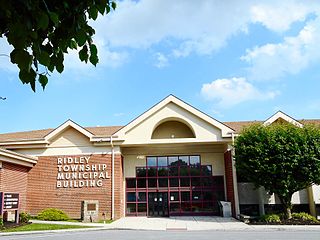
Ridley Township is a township in Delaware County, Pennsylvania, United States. The population was 30,768 at the 2010 census. Ridley Township contains the (CDPs) of Folsom and Woodlyn, along with the unincorporated communities of Crum Lynne and Holmes and a portion of Secane.

<span class="mw-page-title-main">Sharon Hill, Pennsylvania</span> Borough in Pennsylvania, United States

Sharon Hill is a borough in Delaware County, Pennsylvania, United States. The population was 5,697 at the 2010 census. Currently the population stands at 6,356 residents.

<span class="mw-page-title-main">Trainer, Pennsylvania</span> Borough in Pennsylvania, United States

Trainer is a borough in Delaware County, Pennsylvania, United States. The population was 1,828 at the 2010 census, down from 1,901 at the 2000 census. The borough was named after David Trainer, a wealthy textile manufacturer.

<span class="mw-page-title-main">Delaware Water Gap, Pennsylvania</span> Borough in Pennsylvania, United States

Delaware Water Gap is a borough in Monroe County, Pennsylvania, United States. It is located adjacent to the Delaware Water Gap, the pass through which the Lackawanna Corridor and Interstate 80 run across the Pennsylvania-New Jersey border along the Delaware River.

<span class="mw-page-title-main">Green Lane, Pennsylvania</span> Borough in Pennsylvania, United States

Green Lane is a borough in Montgomery County, Pennsylvania. The population was 490 at the 2020 census. It is part of the Upper Perkiomen School District and Boyertown Area School District.

<span class="mw-page-title-main">Roseto, Pennsylvania</span> Place in Pennsylvania, United States

Roseto is a borough in Northampton County, Pennsylvania. The population of Roseto was 1,567 at the 2010 census. Roseto is part of the Lehigh Valley metropolitan area, which has a population of 861,899 and is the 68th most populated metropolitan area in the U.S. as of the 2020 census.

<span class="mw-page-title-main">Midway, Washington County, Pennsylvania</span> Borough in Pennsylvania, United States

Midway is a borough that is located in Washington County, Pennsylvania, United States. The population was 921 at the time of the 2020 census.

<span class="mw-page-title-main">Nicholson, Pennsylvania</span> Borough in Pennsylvania, United States

Nicholson is a borough in Wyoming County, Pennsylvania. The population was 698 at the 2020 census.

<span class="mw-page-title-main">Chester Township, Pennsylvania</span> Home rule municipality in Pennsylvania, United States

Chester Township is a township in Delaware County, Pennsylvania, United States. The population was 3,940 at the 2010 census, down from 4,604 at the 2000 census.

Interboro School District is a midsized, suburban public school district located in southeastern Pennsylvania, just outside Philadelphia in Delaware County. Interboro School District encompasses approximately 11 square miles. The district is made up of four communities: the boroughs of Glenolden, Norwood, and Prospect Park, and Tinicum Township. At one time the area was divided into separate school districts: Glen-Nor, Prospect Park, and Lester. In 1955 Glen-Nor and Prospect Park joined with Lester being included later. The first graduating class of Interboro High School was in 1956 with 125 members. According to 2000 federal census data, Interboro School District serves a resident population of 24,408. In 2009, the district residents’ per capita income was $19,983, while the median family income was $51,323. In the Commonwealth, the median family income was $49,501 and the United States median family income was $49,445, in 2010.

References

  1. "ArcGIS REST Services Directory". United States Census Bureau. Retrieved October 12, 2022.
  2. 1 2 "Census Population API". United States Census Bureau. Retrieved Oct 12, 2022.
  3. 1 2 "Geographic Identifiers: 2010 Demographic Profile Data (G001): Glenolden borough, Pennsylvania". U.S. Census Bureau, American Factfinder. Archived from the original on February 13, 2020. Retrieved December 24, 2015.
  4. "US Gazetteer files: 2010, 2000, and 1990". United States Census Bureau. 2011-02-12. Retrieved 2011-04-23.
  5. "Glenolden Borough map" (PDF). PennDOT. Retrieved March 12, 2023.
  6. "Census of Population and Housing". U.S. Census Bureau. Retrieved 11 December 2013.
  7. 1 2 "U.S. Census website". United States Census Bureau . Retrieved 2008-01-31.
  8. "Incorporated Places and Minor Civil Divisions Datasets: Subcounty Resident Population Estimates: April 1, 2010 to July 1, 2012". Population Estimates. U.S. Census Bureau. Archived from the original on June 11, 2013. Retrieved 11 December 2013.
  9. "Census 2020".
  10. "Women's Basketball Illinois Fighting Illini :: The Official Athletic Site". Archived from the original on 2007-04-04. Retrieved 2007-04-26.