Rutledge, Pennsylvania

Last updated
Rutledge, Pennsylvania
Borough Hall Rutledge, PA.JPG
Borough Hall
Delaware County Pennsylvania incorporated and unincorporated areas Rutledge highlighted.svg
Location in Delaware County and the U.S. state of Pennsylvania
USA Pennsylvania location map.svg
Red pog.svg
Rutledge
Location of Rutledge in Pennsylvania
Usa edcp location map.svg
Red pog.svg
Rutledge
Rutledge (the United States)
Coordinates: 39°54′03″N75°19′39″W / 39.90083°N 75.32750°W / 39.90083; -75.32750
CountryUnited States
StatePennsylvania
County Delaware
Government
  MayorGamal Sherif [1]
Area
[2]
  Total0.14 sq mi (0.37 km2)
  Land0.14 sq mi (0.37 km2)
  Water0.00 sq mi (0.00 km2)
Elevation
128 ft (39 m)
Population
 (2020)
  Total782
  Estimate 
(2022) [3]
778
  Density5,587.41/sq mi (2,157.51/km2)
Time zone UTC-5 (EST)
  Summer (DST) UTC-4 (EDT)
ZIP code
19070
Area code(s) 610 and 484
FIPS code 42-045-66928
FIPS code 42-66928
GNIS feature ID1204564
Website www.rutledgepa.org

Rutledge is a borough in Delaware County, Pennsylvania, United States. The population was 782 at the 2020 census, [4] down from 860 at the 2000 census.

Contents

History

Rutledge was founded in 1885 by a group of Philadelphia businessmen, and incorporated as a borough in 1887. A promotional brochure produced in 1897 described the community as follows:

"Located ten miles from Philadelphia, on the line of the Central Division of the Philadelphia, Wilmington and Baltimore Railroad, three minutes walk from Morton Station – it is reached in from 20 to 30 minutes by 21 trains daily… To the west lies the magnificent Swarthmore College, and to the southeast, three miles away, lies the Delaware River... its school is one of the finest in the county; its houses are neat and attractive, and their owners take great pride in their homes and the adornment of their grounds."

House in Rutledge built 1900 House in Rutledge, PA.JPG
House in Rutledge built 1900

Since then, there have been a few name changes. The train line is SEPTA's Media/Wawa Line, which provides 26 trains on weekdays from Philadelphia to what is now called the Morton-Rutledge Station. But in many ways, this description still holds true today. The schools in the Wallingford-Swarthmore School District are among the finest in the state, [5] and the homes, many of them dating back to the late 19th century, are still kept with pride by their owners.

Keystone Marker perpetuating the myth that the borough was named after Ann Rutledge Rutledge, PA Keystone Marker.jpg
Keystone Marker perpetuating the myth that the borough was named after Ann Rutledge

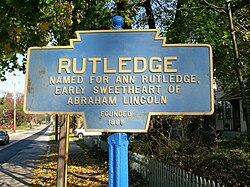
There is a long-standing legend that the borough was named after Ann Rutledge, the first-love of Abraham Lincoln. This erroneous story is perpetuated in the Keystone Marker that greets those approaching Rutledge from the south on Morton Avenue. The actual story, according to the founders' brochure, is that the town was named after a then-popular romantic novel Rutledge written by Miriam Coles Harris published in 1860. However, the site of what is now Rutledge borough was once a section of land on the estate of Edward Rutledge,[ citation needed ] who served as a delegate to the Continental Congress from South Carolina and was the youngest signer of the Declaration of Independence.

In 1958, George Raymond, the president of the NAACP Chester branch, purchased a house in Rutledge. The day before he was to move in, a fire burned down the house. [6] After the fire, the township attempted to exercise eminent domain and claim Raymond's property as a site for a new town hall. Raymond threatened legal action and the township backed down. The house was rebuilt and Raymond took residence in the house in 1959. [7]

Geography

Rutledge is located in eastern Delaware County at 39°54′3″N75°19′39″W / 39.90083°N 75.32750°W / 39.90083; -75.32750 (39.900812, -75.327404). [8] It is nearly surrounded by Ridley Township, with the northernmost tip of the borough touching the borough of Morton. The unincorporated community of Folsom in Ridley Township borders Rutledge to the south.

According to the United States Census Bureau, Rutledge has a total area of 0.14 square miles (0.37 km2), all land. [2]

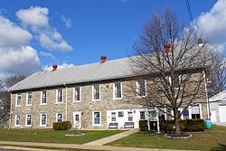
Triangle Park, a children's park, is located in the borough. Morton-Rutledge Fire Company in Morton serves as its fire department. Rutledge is served by the Swarthmore Police Department.

Demographics

Historical population
CensusPop.Note
1890 269
1900 36937.2%
1910 52341.7%
1920 71135.9%
1930 78911.0%
1940 7960.9%
1950 91915.5%
1960 9473.0%
1970 1,16723.2%
1980 934−20.0%
1990 843−9.7%
2000 8602.0%
2010 784−8.8%
2020 782−0.3%
[4]

As of Census 2010, the racial makeup of the borough was 91.7% White, 2.9% African American, 3.1% Asian, and 2.3% from two or more races. Hispanic or Latino of any race were 1.8% of the population [ dead link ].

As of the census [9] of 2000,[ needs update ] there were 860 people, 297 households, and 217 families residing in the borough. The population density was 6,410.8 inhabitants per square mile (2,475.2/km2). There were 305 housing units at an average density of 2,273.6 per square mile (877.8/km2).

There were 297 households, out of which 40.1% had children under the age of 18 living with them, 61.3% were married couples living together, 9.1% had a female householder with no husband present, and 26.6% were non-families. 22.2% of all households were made up of individuals, and 10.1% had someone living alone who was 65 years of age or older. The average household size was 2.87 and the average family size was 3.44.

The population was spread out, with 30.3% under the age of 18, 7.0% from 18 to 24, 27.6% from 25 to 44, 23.6% from 45 to 64, and 11.5% who were 65 years of age or older. The median age was 38 years. For every 100 females, there were 96.3 males. For every 100 females age 18 and over, there were 87.2 males.

The median income for a household in the borough was $80,972, and the median income for a family was $90,333. Males had a median income of $46,500 versus $33,281 for females. The per capita income for the borough was $51,800. About 4.1% of families and 5.3% of the population were below the poverty line, including 2.7% of those under age 18 and 12.1% of those age 65 or over.

Education

Rutledge lies within the Wallingford-Swarthmore School District. Public school children in the borough attend Swarthmore-Rutledge School for grades K–5, Strath Haven Middle School for grades 6–8, and Strath Haven High School for grades 9–12. Rutledge originally had its own one-school district, which was located in the current borough building. The Rutledge and Swarthmore School Districts merged in 1955. [10]

Transportation

Sylvan Avenue in Rutledge 2022-10-24 12 32 36 View northwest along Sylvan Avenue just northwest of Unity Terrace in Rutledge, Delaware County, Pennsylvania.jpg
Sylvan Avenue in Rutledge

As of 2008, there were 3.33 miles (5.36 km) of public roads in Rutledge, of which 0.43 miles (0.69 km) were maintained by the Pennsylvania Department of Transportation (PennDOT) and 2.90 miles (4.67 km) were maintained by the borough. [11]

No numbered highways serve Rutledge directly. Main thoroughfares in the borough include Morton Avenue, which follows a southwest-to-northeast alignment along Rutledge's northwestern border, and Sylvan Avenue, which follows a northwest-to-southeast alignment through the heart of the borough.

Related Research Articles

<span class="mw-page-title-main">Delaware County, Pennsylvania</span> County in Pennsylvania, United States

Delaware County, colloquially referred to as Delco, is a county in the Commonwealth of Pennsylvania. With a population of 576,830 as of the 2020 census, it is the fifth-most populous county in Pennsylvania and the third-smallest in area. The county was created on September 26, 1789, from part of Chester County and named for the Delaware River.

<span class="mw-page-title-main">Folsom, Pennsylvania</span> Census-designated place in Pennsylvania, United States

Folsom is a census-designated place (CDP) in Delaware County, Pennsylvania, United States. It is part of Ridley Township. The population was 8,323 at the 2010 census.

<span class="mw-page-title-main">Lower Chichester Township, Pennsylvania</span> Township in Pennsylvania, United States

Lower Chichester Township is a township in Delaware County, Pennsylvania, United States. The population was 3,469 at the 2010 census. It contains the census designated place of Linwood.

<span class="mw-page-title-main">Media, Pennsylvania</span> Borough in Pennsylvania, United States

Media is a borough in and the county seat of Delaware County, Pennsylvania, United States. It is located about 13 miles (21 km) west of Philadelphia. It is part of the Delaware Valley.

<span class="mw-page-title-main">Morton, Pennsylvania</span> Borough in Pennsylvania, United States

Morton is a borough in Delaware County, Pennsylvania, United States. The population was 2,778 at the 2020 census.

<span class="mw-page-title-main">Norwood, Pennsylvania</span> Borough in Pennsylvania, United States

Norwood is a borough that is located in Delaware County, Pennsylvania, United States. The population was 5,890 at the time of the 2010 census.

<span class="mw-page-title-main">Prospect Park, Pennsylvania</span> Borough in Pennsylvania, United States

Prospect Park is a borough in Delaware County, Pennsylvania, United States. The population was 6,454 at the 2010 census, down from 6,594 at the 2000 census. It originated as a bedroom community of Philadelphia. It is located within 10 miles (16 km) of Center City, Philadelphia, with convenient rail access.

<span class="mw-page-title-main">Ridley Township, Pennsylvania</span> Township in Pennsylvania, United States

Ridley Township is a township in Delaware County, Pennsylvania, United States. The population was 30,768 at the 2010 census. Ridley Township contains the (CDPs) of Folsom and Woodlyn, along with the unincorporated communities of Crum Lynne and Holmes and a portion of Secane.

<span class="mw-page-title-main">Ridley Park, Pennsylvania</span> Borough in Pennsylvania, United States

Ridley Park is a borough in Delaware County, Pennsylvania, United States. The population was 7,002 at the 2010 census. Ridley Park is the home of Boeing's CH-47 Chinook helicopter division.

<span class="mw-page-title-main">Rose Valley, Pennsylvania</span> Borough in Pennsylvania, United States

Rose Valley is a small, historic borough in Delaware County, Pennsylvania, United States. Its area is 0.73 square miles (1.9 km2), and the population was 913 at the 2010 census. The area was settled by Quaker farmers in 1682, and later water mills along Ridley Creek drove manufacturing in the nineteenth century.

<span class="mw-page-title-main">Sharon Hill, Pennsylvania</span> Borough in Pennsylvania, United States

Sharon Hill is a borough in Delaware County, Pennsylvania, United States. The population was 5,697 at the 2010 census. Currently the population stands at 6,356 residents.

<span class="mw-page-title-main">Springfield Township, Delaware County, Pennsylvania</span> Township in Pennsylvania, United States

Springfield Township, or simply Springfield, is a township in Delaware County in the U.S. state of Pennsylvania. The population was 25,070 at the 2020 census. Springfield is a suburb of Philadelphia, located about 4 miles (6.4 km) west of the city.

<span class="mw-page-title-main">Swarthmore, Pennsylvania</span> Borough in Pennsylvania, United States

Swarthmore is a borough in Delaware County, Pennsylvania, United States. Swarthmore was originally named "Westdale" in honor of noted painter Benjamin West, who was one of the early residents of the town. The name was changed to "Swarthmore" after the establishment of Swarthmore College. The borough population was 6,194 as of the 2010 census.

<span class="mw-page-title-main">Trainer, Pennsylvania</span> Borough in Pennsylvania, United States

Trainer is a borough in Delaware County, Pennsylvania, United States. The population was 1,828 at the 2010 census, down from 1,901 at the 2000 census. The borough was named after David Trainer, a wealthy textile manufacturer.

<span class="mw-page-title-main">Woodlyn, Pennsylvania</span> Census-designated place in Pennsylvania, United States

Woodlyn is a census-designated place (CDP) in Delaware County, Pennsylvania, United States. The population was 9,485 at the 2010 census, down from 10,036 at the 2000 census. It is a part of Ridley Township, and children residing within the community generally attend schools in the Ridley School District. Woodlyn is served by the Woodlyn Fire Co. for fire, rescue and EMS services.

<span class="mw-page-title-main">Chester Township, Pennsylvania</span> Home rule municipality in Pennsylvania, United States

Chester Township is a township in Delaware County, Pennsylvania, United States. The population was 3,940 at the 2010 census, down from 4,604 at the 2000 census.

<span class="mw-page-title-main">Nether Providence Township, Pennsylvania</span> Township in Pennsylvania, United States

Nether Providence Township is a first class township in Delaware County, Pennsylvania, United States. Many residents refer to the township by the name of its largest community, Wallingford, because the Wallingford postal code is used for most of the township. The population of the township was 13,706 at the 2010 census.

<span class="mw-page-title-main">Wallingford, Pennsylvania</span> Place in Pennsylvania, United States

Wallingford is an unincorporated community in Nether Providence Township, Delaware County, Pennsylvania, United States. Founded in 1687, it is named for Wallingford, England. In 2007, Wallingford was named by Money Magazine as the ninth best place to live in the United States; two other towns in the area made the top 15. Most locations in Nether Providence use Wallingford's ZIP code.

<span class="mw-page-title-main">Wallingford-Swarthmore School District</span> Midsized, suburban public school district in south-eastern Delaware County, Pennsylvania

Wallingford-Swarthmore School District is a midsized, suburban public school district in south-eastern Delaware County, Pennsylvania in the United States. It serves the boroughs of Swarthmore, Rose Valley and Rutledge, and the township of Nether Providence. It encompasses approximately seven square miles.

Swarthmore High School was a four-year public high school in Swarthmore, Pennsylvania serving the Boroughs of Swarthmore and Rutledge.

References

  1. "Borough Government". Borough of Rutledge. Retrieved 17 February 2022.
  2. 1 2 "2019 U.S. Gazetteer Files". United States Census Bureau. Retrieved July 28, 2020.
  3. "Population and Housing Unit Estimates". United States Census Bureau. May 24, 2020. Retrieved May 27, 2020.
  4. 1 2 "Census 2020".
  5. "Strath Haven High School in Wallingford, PA". US News Best High Schools. #21 in Pennsylvania High Schools
  6. NAACP: Celebrating a Century, 100 years in Pictures. Layton, Utah: Gibbs Smith. 2009. p. 206. ISBN   978-1-4236-0527-0 . Retrieved 14 July 2018.
  7. McLarnon, John M. (2002). "Old Scratchhead" Reconsidered: George Raymond & Civil Rights in Chester, Pennsylvania". Pennsylvania History. 69 (3): 310. Retrieved 15 July 2018.
  8. "US Gazetteer files: 2010, 2000, and 1990". United States Census Bureau. 2011-02-12. Retrieved 2011-04-23.
  9. "U.S. Census website". United States Census Bureau . Retrieved 2008-01-31.
  10. "ABOUT WALLINGFORD-SWARTHMORE SCHOOL DISTRICT".
  11. "Rutledge Borough map" (PDF). PennDOT. Retrieved March 12, 2023.