Fort Robinson (Pennsylvania)

Last updated
Fort Robinson
Perry County, Pennsylvania, USA
USA Pennsylvania location map.svg
Red pog.svg
Fort Robinson
Approximate location of Fort Robinson in Pennsylvania
Coordinates 40°22.028′N77°23.411′W / 40.367133°N 77.390183°W / 40.367133; -77.390183
TypeFort
Site information
Controlled byPrivately owned land
Site history
Built1755
In use1755-1764
Battles/wars French and Indian War, Pontiac's War
Garrison information
Past
commanders
George Robinson
Garrisonup to 40 men, local settlers
Designated1947

Fort Robinson (often referred to in contemporary documents as George Robinson's Fort or simply Robinson's Fort) was a stockaded blockhouse fort built in 1755 in the colonial Province of Pennsylvania for the security of settlers moving into the area following the Albany Congress. The fort was constructed in "Shearman's Valley," now known as Shermans Dale, Pennsylvania, near present-day Northeast Madison Township, Pennsylvania. [1]

Contents

Location and construction

Reconstructed stockade and blockhouse similar to the original Fort Robinson. Elizabeth Il Apple River Fort2.JPG
Reconstructed stockade and blockhouse similar to the original Fort Robinson.

Harry Harrison Hain describes the fort in his History of Perry County:

"It was a log fort, surrounded by a stockade. It occupied a site...located on a tableland with a good view of the surrounding country...The lowlands below were heavily wooded with large oak and maple, which also afforded protection in going to the fort. A spring was located at the foot of the bluff where water was secured with the least exposure, the distance from the stockade being only the steep bank — probably twenty feet...The fort was evidently in the nature of a block house, surrounded by a stockade built of heavy planks or poles. It was located along the famous Allegheny or Traders' Path and was the only source of protection for the traveler along the Allegheny Path between the Kittatinny or Blue Mountain and the Tuscarora." [2] :98

The fort was built on a bluff overlooking Bixler's Run, a tributary of Shermans Creek, on land owned by George Robinson (1727-1814, also spelled Robison or Robeson), a homesteader who later became a justice of the peace and fought in the American Revolutionary War. His son James was killed in 1756 at the Battle of Sideling Hill and two other sons, William and Thomas, were killed defending Fort Robinson in 1763. His grandson, James Fisher Robinson, was governor of Kentucky. [1] :14

The fort was located centrally in Shearman's Valley, on high ground with visibility in all directions. It stood close to a well-traveled trade route from Shearman's Valley to Harris' Ford, later the site of Harrisburg. [3] :611 The fort was built with private funds by local settlers and most likely consisted of a stockade surrounding a two-storey blockhouse, typical of non-military forts of that period. As of July, 1756 the fort was capable of housing 40 men and their families, although no militia were posted there. It was not occupied unless settlers needed to move there for security. [1] :14

History

Capture of Hugh Gibson

The earliest reference to the fort comes from the narrative of Hugh Gibson, who was captured in July, 1756 by Delaware Indians. In his first-person account published in 1811, he states that he was living at the time outside Robinson's Fort. Due to recent attacks by Indians, most of the local population had taken refuge inside the fort. [4] :16 Nearly all the adult males were either working in the fields and only two men remained at the fort as guards. [5] Gibson, his mother, and Elizabeth Henry, a neighbor, were outside the fort looking for lost cattle when they were attacked by Lenape warriors. Gibson's mother was killed and he was taken captive by "a son of King Beaver." [6] :142 Elizabeth Henry was also captured, but the two were separated and Gibson never saw her again. [7] Indians attacked the fort at the same time, killing a woman and a guard before the men in the fields returned to drive them off. [1] :17–18

Woolcomber Massacre

In late 1756, men at the fort were alerted when a boy arrived reporting that his parents and siblings were killed by Indians. [8] :37 This event is referred to as the Woolcomber Massacre. [2] :73 Forty men were sent out from the fort to the Woolcomber homestead to bury the deceased. [9] :161 On 10 January 1758 James Patterson wrote to Deputy Governor William Denny from Fort Hunter: "I took with (me) 19 men & ranged from this Fort as far as Robinson's Fort, where I lodged, keeping a guard of six men & one Corporal on Centry that night." [1] :10

Battle of Buffalo Creek

In July 1763, during Pontiac's War, Shawnee Indians raided the farms of William White and William Anderson, killing all but one of the inhabitants, a 15-year-old boy. Because of the war, many local settlers had taken refuge in Fort Robinson, but some had decided to return to their farms to harvest their fields. A dozen men from the fort, including three of George Robinson's sons, volunteered to try to reach those settlers who were harvesting in order to warn them. They also hoped to encounter the Shawnee war party and drive them off. The Shawnees discovered that they were being followed and ambushed the Robinson party at Buffalo Creek, killing five of them before the settlers fled. Two of George Robinson's sons, William and Thomas, were killed, but Robert Robinson escaped. He and the other survivors took several days to return to the fort. [1] :23–25 This encounter is known as the Battle of Buffalo Creek. [10]

Abandonment, 1764

The fort was most likely abandoned after hostilities in Pontiac's War ended in late 1764. Traces of the fort were still visible in 1896, in an orchard planted after the fort was torn down. [3] :617

Archaeology

Attempts to locate and excavate the fort began in 2006, when test pits were dug near the 1922 historical marker. Dozens of unproductive pits were dug in 2006, 2007 and 2008. In 2009, the dig was moved to the former location of the Fort Robinson Railroad Station, but no evidence of the fort was uncovered. Archaeologists are now investigating another site, along an old Indian trail known as the "New Path" or the "New Trail" where it crosses Shermans Creek. [11]

Legacy

A stone monument dedicated in 1922 by the Perry County Historical Society can be seen on Pennsylvania Route 850 (Fort Robinson Road) on Bixler's Run, near Northeast Madison Township, Pennsylvania. [12] [13] A historical marker, erected in 1947 by the Pennsylvania Historical and Museum Commission, is visible nearby. [14]

Further reading

Related Research Articles

<span class="mw-page-title-main">Shirleysburg, Pennsylvania</span> Borough in Pennsylvania, United States

Shirleysburg is a borough in Huntingdon County, Pennsylvania, United States. The population was 150 at the 2010 census.

<span class="mw-page-title-main">Kittanning (village)</span> Historic Native American village in Pennsylvania

Kittanning was an 18th-century Native American village in the Ohio Country, located on the Allegheny River at present-day Kittanning, Pennsylvania. The village was at the western terminus of the Kittanning Path, an Indian trail that provided a route across the Alleghenies between the Ohio and Susquehanna river basins.

<span class="mw-page-title-main">Juniata River</span> River in Pennsylvania, United States

The Juniata River is a tributary of the Susquehanna River, approximately 104 miles (167 km) long, in central Pennsylvania. The river is considered scenic along much of its route, having a broad and shallow course passing through several mountain ridges and steeply lined water gaps. It formed an early 18th-century frontier region in Pennsylvania and was the site of French-allied Native American attacks against English colonial settlements during the French and Indian War.

<span class="mw-page-title-main">Fort Loudoun (Pennsylvania)</span> 18thCentury fort in Pennsylvania

Fort Loudoun was a fort in colonial Pennsylvania, one of several forts in colonial America named after John Campbell, 4th Earl of Loudoun. The fort was built in 1756 during the French and Indian War by the Second Battalion of the Pennsylvania Regiment under Colonel John Armstrong, and served as a post on the Forbes Road during the Forbes expedition that successfully drove the French away from Fort Duquesne. The fort remained occupied through Pontiac's War and served as a base for Colonel Henry Bouquet's 1764 campaign. In the 1765 Black Boys Rebellion, Fort Loudoun was assaulted by angry settlers, when their guns were confiscated after they destroyed supplies intended for Native Americans. The garrison retreated to Fort Bedford and the fort was abandoned.

Fort Halifax was located along the Susquehanna River near the present day borough of Halifax, Pennsylvania, United States. It was a temporary stronghold in northern Dauphin County, Pennsylvania, from 1756 to 1757, during the time of the French and Indian War.

Tewea, better known by his English name Captain Jacobs, was a Lenape chief during the French and Indian War. Jacobs received his English name from a Pennsylvanian settler named Arthur Buchanan, who thought the chief resembled a "burly German in Cumberland County."

Manada Gap is an unincorporated community in East Hanover Township, Dauphin County, Pennsylvania, United States, located in the Harrisburg-Carlisle area, near Fort Indiantown Gap.

Anne Rowe Hupp was an American frontierswoman of the Buffalo Creek Valley in Washington County, Pennsylvania. She led the defense of a small, isolated fort, Miller's Blockhouse, against a Shawnee Indian Attack, for more than twenty-four hours in 1782 while she was eight months pregnant.

The Battle of Sideling Hill was an engagement in April 1756, between Pennsylvania Colonial Militia and a band of Lenape warriors who had attacked Fort McCord and taken a number of colonial settlers captive. The warriors were taking their captives back to their base at Kittanning when they were ambushed by the militia, but with the help of reinforcements, the Lenape fought off the militia and escaped. The battle is significant because it was the first engagement involving Pennsylvania Militia after Braddock's defeat.

<span class="mw-page-title-main">Fort Granville</span> 18th century fort in colonial Pennsylvania, U. S.

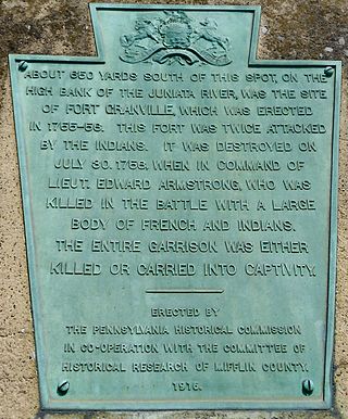
Fort Granville was a militia stockade located in the colonial Province of Pennsylvania. Its site was about a mile from Lewistown, in what is now Granville Township, Mifflin County. Active from 1755 until 1756, the stockade briefly sheltered pioneer settlers in the Juniata River valley during the French and Indian War. The fort was attacked on August 2, 1756, by a mixed force of French troops and Native Americans, mostly Lenape warriors. The fort’s garrison surrendered the strongpoint to these attackers, who celebrated their victory and destroyed the stockade.

<span class="mw-page-title-main">Fort Juniata Crossing</span> 18th century fort in colonial Pennsylvania

Fort Juniata Crossing, also known as Fort Juniata or simply Juniata Crossing, was a British French and Indian War era fortification located along the Forbes Road, near a strategic ford of the Raystown Branch of the Juniata River about 2.4 miles (3.9 km) west of the current site of Breezewood, Pennsylvania. It was built in 1758 as a fortified supply depot, to support the British Army during the Forbes Expedition. After the campaign, it fell into disrepair and was abandoned in 1763.

<span class="mw-page-title-main">Fort Shirley</span> 18th-century fort in colonial Pennsylvania

Fort Shirley was a military fort located in present-day Shirleysburg, Pennsylvania. It was built in 1755 by George Croghan and later maintained by the Province of Pennsylvania during the French and Indian War. Fort Shirley was part of a defensive line of forts built in Pennsylvania during 1755 and 1756, at the start of hostilities with the French and their allied Native Americans. Although two French and Native American war parties were sent to capture it, Fort Shirley was never attacked. The fort served as the launching site for the Kittanning Expedition in September 1756, after which it was abandoned.

<span class="mw-page-title-main">Buffalo Creek (Ohio River tributary)</span> Tributary of the Ohio River

Buffalo Creek is a stream which runs through the United States commonwealths of Pennsylvania and West Virginia. It rises in East Finley Township, Washington County, Pennsylvania.

<span class="mw-page-title-main">Fort Swatara</span> French and Indian War fort in Pennsylvania, U.S.

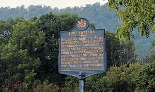
Fort Swatara was a stockaded blockhouse built during the French and Indian War in what is now Lebanon County, Pennsylvania. Initially a farmstead surrounded by a stockade, provincial troops occupied it in January 1756. The fort safeguarded local farms, but a number of settlers were killed by small Native American war parties. The fort was abandoned in May 1758.

<span class="mw-page-title-main">Fort Lyttleton (Pennsylvania)</span> Fort in colonial Pennsylvania, USA

Fort Lyttleton, also known as Fort Littleton, was a militia stockade located in the colonial Province of Pennsylvania. Its site was about a mile from Fort Littleton, Pennsylvania, near Dublin Township, in what is now Fulton County, Pennsylvania. Active from 1755 until 1763, the stockade was initially garrisoned by 75 Pennsylvania troops but at times had as many as 225. It was in use until 1759, then abandoned and reoccupied briefly in 1763 during Pontiac's War.

Fort Bigham was a privately built stockaded blockhouse fort constructed in 1754 near present-day Honey Grove in Tuscarora Township, Juniata County, Pennsylvania. It was built by Samuel Bigham on his land to protect his family and neighbors from Indians. In June, 1756 the fort was attacked and the people in it, mostly women and children, were all captured or killed. The fort was largely destroyed. It was rebuilt in 1760 and abandoned in 1763.

<span class="mw-page-title-main">Great Cove massacre</span> Attack by Lenape and Shawnee warriors on a Pennsylvania pioneer settlement in 1755

The Great Cove massacre was an attack by Shawnee and Lenape warriors led by Shingas, on the community of Great Cove, Pennsylvania on 1 November 1755, in which about 50 settlers were killed or captured. Following the attack, settlers returned to the community to rebuild, and the Provincial Council of Pennsylvania began constructing a chain of forts and blockhouses to protect settlers and fend off further raids. These forts provided an important defense during the French and Indian War.

<span class="mw-page-title-main">Gnadenhütten massacre (Pennsylvania)</span> Attack by Native American warriors on a Pennsylvania Moravian settlement in 1755.

The Gnadenhütten massacre was an attack during the French and Indian War in which Native allies of the French killed 11 Moravian missionaries at Gnadenhütten, Pennsylvania on 24 November 1755. They destroyed the mission village and took one woman prisoner, and only four of the sixteen residents escaped. Following the attack, Benjamin Franklin was commissioned by the Pennsylvania Provincial Council to construct forts in the area, and in other parts of the Province of Pennsylvania, to defend against Native American attacks, which were becoming increasingly frequent due to the French and Indian War.

<span class="mw-page-title-main">Fort Northkill</span> 18th century fort in colonial Pennsylvania

Fort Northkill was a fort in colonial Pennsylvania, built to protect settlers from attacks by French-allied Native Americans during the French and Indian War. Although the fort was garrisoned by Pennsylvania militia, they were unable to prevent continued attacks on local farmsteads, but the fort did provide some protection for the settlers themselves. The fort appears to have been abandoned in September 1757, but the exact date is unknown.

References

  1. 1 2 3 4 5 6 D. A. Kline, Luke Baker, "Account of Fort Robinson," Historical Society of Perry County, Pennsylvania, 1924
  2. 1 2 Harry Harrison Hain, History of Perry County, Pennsylvania, including descriptions of Indians and pioneer life from the time of earliest settlement, Hain-Moore Company, Harrisburg, PA, 1922
  3. 1 2 Clarence M. Busch, Report of the Commission to Locate the Site of the Frontier Forts of Pennsylvania, Vol. 1, State Printer of Pennsylvania, 1896
  4. Silas Wright, History of Perry County, in Pennsylvania, from the Earliest Settlement to the Present Time. Lancaster, PA: Wylle & Griest, Printers, Book-binders and Stereotyping, 1873
  5. Joe G. Darlington, "Addresses on Historic Places and Eminent Men: Fort Robinson," The Perry County Democrat, Bloomfield, Pennsylvania, Wed, Sep 14, 1932; Page 1
  6. Timothy Alden, "An Account of the Captivity of Hugh Gibson among the Delaware Indians of the Big Beaver and the Muskingum, from the latter part of July 1756, to the beginning of April, 1759," Collections of the Massachusetts Historical Society, 1837
  7. Heard, Joseph Norman, "The Assimilation of Captives on the American Frontier in the Eighteenth and Nineteenth Centuries." (1977). LSU Historical Dissertations and Theses.
  8. A history of the Juniata Valley in three volumes, National Historical Association, The Telegraph Press, Harrisburg, PA, 1936
  9. Archibald Loudoun, A Selection of Some of the Most Interesting Narratives, of Outrages, Committed by the Indians, in Their Wars with the White People, A. Loudoun Press, Carlisle, 1811; pp. 181-186
  10. Dennis J. Hocker, Three Bloody Days in July: The Battle of Buffalo Creek in Perry and Juniata Counties, Book 1 of Perry Heritage Collection. Genesis Capital Group, 2011
  11. Wade Fowler, "Researcher digs to find location of historic site," Perry County Times, Jul. 29, 2010
  12. "Fort Robinson: Pennsylvania Historical Marker," Waymarking.com, June 2012
  13. Pete Payette, "Pennsylvania Forts: Southern Pennsylvania II," North American Forts, 12 October 2014
  14. Don Morfe, "Fort Robinson," Historical Marker Database, February 7, 2023