
The Province of Pennsylvania, also known as the Pennsylvania Colony, was a British North American colony founded by William Penn, who received the land through a grant from Charles II of England in 1681. The name Pennsylvania was derived from "Penn's Woods", referring to William Penn's father Admiral Sir William Penn.

Kittanning was an 18th-century Native American village in the Ohio Country, located on the Allegheny River at present-day Kittanning, Pennsylvania. The village was at the western terminus of the Kittanning Path, an Indian trail that provided a route across the Alleghenies between the Ohio and Susquehanna river basins.

The Kittanning Expedition, also known as the Armstrong Expedition or the Battle of Kittanning, was a raid during the French and Indian War that led to the destruction of the American Indian village of Kittanning, which had served as a staging point for attacks by Lenape warriors against colonists in the British Province of Pennsylvania. Commanded by Lieutenant Colonel John Armstrong Sr., this raid deep into hostile territory was the only major expedition carried out by Pennsylvanian provincial troops during a brutal backcountry war. Early on September 8, 1756, they launched a surprise attack on the Indian village.
The Pocono Record is a daily newspaper published in print and online in Stroudsburg, Pennsylvania, United States.
Fort Venango was a small British fort built in 1760 near the present-day site of Franklin, Pennsylvania. It replaced Fort Machault, a French fort built at the confluence of French Creek and the Allegheny River. In August 1759, near the end of the French and Indian War, after the French surrender of Fort Niagara to the British, the French burned Fort Machault and retreated north. Fort Venango was built during summer 1760. It was attacked and destroyed in June 1763 during Pontiac's War.
Fort Augusta was a stronghold in Northumberland County, Pennsylvania, in the upper Susquehanna Valley from the time of the French and Indian War to the close of the American Revolution. At the time, it was the largest British fort in Pennsylvania, with earthen walls more than two hundred feet long topped by wooden fortifications. With a garrison of over 300 troops and walls specially constructed to resist artillery, it presented a formidable defense and was never attacked. It served as a refuge for local settlers during the French and Indian War and during the American Revolutionary War. It was abandoned in 1780 and dismantled in 1796.

The Draper's Meadow Massacre was an attack in July 1755, when the Draper's Meadow settlement in southwest Virginia, at the site of present-day Blacksburg, was raided by a group of Shawnee warriors, who killed at least four people including an infant, and captured five more. The Indians brought their hostages to Lower Shawneetown, a Shawnee village in Kentucky. One of the captives, Mary Draper Ingles, later escaped and returned home on foot through the wilderness. Although many of the circumstances of the massacre are uncertain, including the date of the attack, the event remains a dramatic story in the history of Virginia.
Manada Gap is an unincorporated community in East Hanover Township, Dauphin County, Pennsylvania, United States, located in the Harrisburg-Carlisle area, near Fort Indiantown Gap.
The Battle of Sideling Hill was an engagement in April 1756, between Pennsylvania Colonial Militia and a band of Lenape warriors who had attacked Fort McCord and taken a number of colonial settlers captive. The warriors were taking their captives back to their base at Kittanning when they were ambushed by the militia, but with the help of reinforcements, the Lenape fought off the militia and escaped. The battle is significant because it was the first engagement involving Pennsylvania Militia after Braddock's defeat.
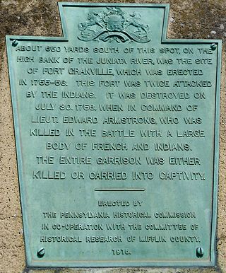
Fort Granville was a militia stockade located in the colonial Province of Pennsylvania. Its site was about a mile from Lewistown, in what is now Granville Township, Mifflin County. Active from 1755 until 1756, the stockade briefly sheltered pioneer settlers in the Juniata River valley during the French and Indian War. The fort was attacked on August 2, 1756, by a mixed force of French troops and Native Americans, mostly Lenape warriors. The fort’s garrison surrendered the strongpoint to these attackers, who celebrated their victory and destroyed the stockade.

Fort Shirley was a military fort located in present-day Shirleysburg, Pennsylvania. It was built in 1755 by George Croghan and later maintained by the Province of Pennsylvania during the French and Indian War. Fort Shirley was part of a defensive line of forts built in Pennsylvania during 1755 and 1756, at the start of hostilities with the French and their allied Native Americans. Although two French and Native American war parties were sent to capture it, Fort Shirley was never attacked. The fort served as the launching site for the Kittanning Expedition in September 1756, after which it was abandoned.

The Minisink or Minisink Valley is a loosely defined geographic region of the Upper Delaware River valley in northwestern New Jersey, northeastern Pennsylvania and New York.
Indian Mountain Lake is a census-designated place (CDP) in Carbon County and Monroe County, Pennsylvania. It is part of Northeastern Pennsylvania.

Fort Depuy, is located in Shawnee on Delaware, a village in Smithfield Township. It was one of many forts in Colonial Pennsylvania built in 1755 and 1756 during the French and Indian War.
William Clapham was an American military officer who participated in the construction of several forts in Pennsylvania during the French and Indian War. He was considered a competent commander in engagements with French troops and Native American warriors, but towards the end of his military career he was unpopular with troops under his command. Following his retirement from the army, he and his family were killed by Lenape warriors on his farm in 1763.
Fort Allen was a military structure built in Franklin Township, in Carbon County, Pennsylvania in 1756. It was first of several frontier defenses erected by Benjamin Franklin for the Province of Pennsylvania during the French and Indian War. The garrison was rarely more than fifty men, and the fort never saw combat, however it became a center of contact and trade with Native Americans and served as a stopping point for Indians traveling to and from Bethlehem, Easton and Philadelphia. It was abandoned in 1761 near the end of the French and Indian War, and briefly reoccupied during Pontiac's War and again during the American Revolutionary War.
Fort Bigham was a privately built stockaded blockhouse fort constructed in 1754 near present-day Honey Grove in Tuscarora Township, Juniata County, Pennsylvania. It was built by Samuel Bigham on his land to protect his family and neighbors from Indians. In June, 1756 the fort was attacked and the people in it, mostly women and children, were all captured or killed. The fort was largely destroyed. It was rebuilt in 1760 and abandoned in 1763.

The Gnadenhütten massacre was an attack during the French and Indian War in which Native allies of the French killed 11 Moravian missionaries at Gnadenhütten, Pennsylvania on 24 November 1755. They destroyed the mission village and took one woman prisoner, and only four of the sixteen residents escaped. Following the attack, Benjamin Franklin was commissioned by the Pennsylvania Provincial Council to construct forts in the area, and in other parts of the Province of Pennsylvania, to defend against Native American attacks, which were becoming increasingly frequent due to the French and Indian War.
Fort Hunter was a military fort located in present-day Fort Hunter, Pennsylvania. It was initially a stockaded gristmill fortified by Samuel Hunter in 1755 and later enlarged and maintained by the Province of Pennsylvania during the French and Indian War. Fort Hunter was part of a defensive line of forts built in Pennsylvania during 1755 and 1756, at the start of hostilities with the French and their allied Native Americans. It was briefly used during Pontiac's War, then abandoned in 1763.
Fort Lebanon was a Pennsylvania stockade fort built in December 1755 and designed to provide protection for settlers' families during the French and Indian War. However, Native American war parties often attacked nearby farms and killed settlers, disappearing before the fort's troops could respond. The garrison was sometimes fewer than 25 men as troops were transferred for temporary duty elsewhere, meaning that the fort had little manpower for patrols or to pursue attackers. The fort was renamed Fort William in mid-1757. In May 1758, the garrison was transferred and the fort was never re-occupied.

