Fort Loudoun (Pennsylvania)

Last updated
Fort Loudoun
Peters Township, Franklin County, Pennsylvania, USA
10491 Fort Loudon - Franklin County, PA 4.jpg
Reconstruction of Fort Loudoun
USA Pennsylvania location map.svg
Red pog.svg
Fort Loudoun
Location of Fort Loudoun in Pennsylvania
Coordinates 39°54′54″N77°54′36″W / 39.915°N 77.91°W / 39.915; -77.91
TypeFort
Site information
Controlled by Commonwealth of Pennsylvania
Site history
Built1756
In use1756-1765
Battles/wars French and Indian War
Pontiac's War
Black Boys Rebellion
Garrison information
Past
commanders
Captain John Potter
Captain Joseph Armstrong
Captain William Armstrong
Captain William Thompson
Lieutenant Charles Grant
Garrison14-100 men plus officers
DesignatedOctober 01, 1915
May 27, 1947

Fort Loudoun (or Fort Loudon, after the modern spelling of the town) was a fort in colonial Pennsylvania, one of several forts in colonial America named after John Campbell, 4th Earl of Loudoun. The fort was built in 1756 during the French and Indian War by the Second Battalion of the Pennsylvania Regiment under Colonel John Armstrong, and served as a post on the Forbes Road during the Forbes expedition that successfully drove the French away from Fort Duquesne. The fort remained occupied through Pontiac's War and served as a base for Colonel Henry Bouquet's 1764 campaign. In the 1765 Black Boys Rebellion, Fort Loudoun was assaulted by angry settlers, when their guns were confiscated after they destroyed supplies intended for Native Americans. The garrison retreated to Fort Bedford and the fort was abandoned.

Contents

History

Fort Loudoun was one of four forts constructed following General Edward Braddock's defeat on July 9, 1755 at the Battle of the Monongahela. At the beginning of the French and Indian War, Braddock's defeat left Pennsylvania without a professional military force. [1] Lenape chiefs Shingas and Captain Jacobs launched dozens of Shawnee and Delaware raids against British colonial settlements, [2] killing and capturing hundreds of colonists and destroying settlements across western and central Pennsylvania. [3] In late 1755, Colonel John Armstrong wrote to Governor Robert Hunter Morris: "I am of the opinion that no other means of defense than a chain of blockhouses along or near the south side of the Kittatinny Mountains from the Susquehanna to the temporary line, can secure the lives and property of the inhabitants of this country, the new settlements being all fled except Shearman's Valley." [4] :557 Construction on several new forts was begun in December 1755. [5] :685

Construction

1763 map of a route through southwest Pennsylvania from Fort Loudoun to Fort Pitt, Pittsburgh. Fort Loudoun is shown in the bottom left corner of the page. Map of a route through south west Pennsylvania from Fort Loudon, Franklin Co. to Fort Pitt, Pittsburgh. LOC gm71000599.jpg
1763 map of a route through southwest Pennsylvania from Fort Loudoun to Fort Pitt, Pittsburgh. Fort Loudoun is shown in the bottom left corner of the page.

Governor Morris ordered these forts to be built under the direction of Colonel Armstrong. In late 1755, construction began on Fort Morris in Shippensburg, Fort Lyttleton, and Fort Carlisle. [6] George Croghan also supervised the construction of Fort Granville and Fort Shirley. [7] Fort Loudoun was intended to replace a simple privately-built stockade at McDowell's Mill, which was too small to adequately defend the area. Shingas had assaulted the mill in February 1756 with 80 warriors and had almost taken it, until the battle was interrupted by a blizzard. [8] :424–36

The siege and destruction of Fort Granville in August 1756 raised fears that the forts were too far apart and too difficult to supply. [6] :392 In September, following the assault on Kittanning, a Lenape staging area for raids on Pennsylvania settlements, Colonel Armstrong decided to place a fort midway between Shippensburg and Fort Lyttleton. The new governor, William Denny, consulted Lieutenant Elias Meyer, a British army engineer, who helped determine a good location for the fort. In November a site was selected near Parnell Knob, on land owned by a farmer Matthew Patton. He had started building a farmhouse, which Armstrong incorporated into the fort, writing to Governor Denny on 19 November:

"I'm makeing the best preparation in my power to forward this Fort, as well as to prepare the barracks, and the others for the approaching winter. Yesterday the Escort of one hundred men returned from Lyttleton who left the Cattle &c, safe there and to-day we begin to Digg a Cellar in the New Fort; the Loggs & Roof of a New House having there been Erected by Patton...We shall apprise this House, and then take the benefit of it, either for Officers' Barracks or a Store-House." [6] :5

Construction of most of the fort's buildings was done by late December, but due to the weather, the stockade was not completed until early spring of 1757. Armstrong hired a team of builders to continue work on the fort, and additions and improvements were still being made in mid-1758. [8] Governor Morris named Fort Loudoun after John Campbell, 4th Earl of Loudoun, Commander-in-Chief of the British military in North America and Governor General of Virginia (1705-1782). [9]

Description

Construction followed a standard design adopted by Governor Robert Hunter Morris, typically a 100-foot square stockade with bastions at the four corners, and several buildings inside, including a barracks, an officers' quarters, a gunpowder magazine, a kitchen and a storehouse. In addition, Morris recommended that the fort be "a square with one ravelin to protect the curtain where the gate is, with a ditch, covered way, and glacis." [10] :54 An external building known as "the Bower" was constructed to serve as a meeting house for conferences with Native Americans, and this was later converted into a summer house for visiting officers and other dignitaries to stay in. Armstrong was assisted in the construction by Captain (later colonel) James Burd. [6] :6 The Reverend Thomas Barton, an army chaplain who was stationed at Fort Loudoun, described Fort Loudoun in a letter on July 21, 1758: "The Fort is a poor Piece of Work, irregularly built, & badly situated at the Bottom of a Hill Subject to Damps & noxious Vapours. It has something like Bastions supported by Props, which if an Enemy should cut away, down tumbles Men & all...The Fort is properly a square Ridout of 120 feet." [6] :8

Military history

View of the reconstruction of Fort Loudoun showing the shooting platforms at each corner. 10491 Fort Loudon - Franklin County, PA 4.jpg
View of the reconstruction of Fort Loudoun showing the shooting platforms at each corner.

The fort was initially garrisoned by 100 troops from the Second Battalion of the Pennsylvania Regiment. [8] In May 1757, 60 Cherokee warriors arrived, and were initially mistaken for enemies. A party of soldiers was sent from Fort Loudoun to attack their camp, but an interpreter was able to stop them. Governor Denny then sent the Cherokees a message, offering guns and gunpowder as payment for their services as scouts. Cherokees later served as rangers and scouts, although they were considered unreliable. [8] :467–469

Fort Loudoun served as an important supply depot during the Forbes Expedition and the construction of the Forbes Road, with troops pausing to camp at the fort frequently as they prepared to attack Fort Duquesne. In June 1758, Colonel Bouquet held a conference in the Bower with over a hundred Cherokee warriors who had offered to join in the expedition. [8] :472–3 In October 1758, Colonel Henry Bouquet recommended that the garrison be maintained at 100 men plus officers. [11] :165 Towards the end of 1758, one of the battalion's companies was replaced by a troop of light cavalry. [8] :472

After the 1758 Treaty of Easton, the fort's garrison was reduced to 14 men. [8] :478 In 1759, Matthew Patton, the owner of the land on which the fort was built, returned and filed a petition with the provincial government for damages to his property. Having no place to live, he was allowed to stay in the fort while rebuilding his farmhouse. [6] :9–10

Fort Loudoun was used by Colonel Bouquet as a base for his campaign of 1764. [12] In a letter written on 15 August 1764, Bouquet noted that the fort was already deteriorating: "The store houses for Provisions at this Fort are in a ruinous Condition, having originally been only little huts of Logs for Provincial Soldiers, and Swarming with Rats, by which the Provisions suffer considerably." The fort was subsequently garrisoned by a detachment of the 42nd Royal Highland Regiment of Foot, known as the Black Watch. [8] :475

Black Boys Rebellion, 1765

1770 map of the Province of Pennsylvania showing Fort Loudoun at the center of the map's lower edge. To the Honorable Thomas Penn and Richard Penn, Esquires, true and absolute proprietaries and Governors of the Province of Pennsylvania and the territories thereunto belonging and to the Honorable John LOC 74692505.jpg
1770 map of the Province of Pennsylvania showing Fort Loudoun at the center of the map's lower edge.

In March 1765 a pack train of goods owned by George Croghan was intercepted by Pennsylvania settlers, who were concerned that "warlike goods" including weapons and rum were being sent to Native Americans in exchange for land and other favors, in defiance of the Royal Proclamation of 1763 which forbade the sale of "war-like" trade items (guns, knives, tomahawks, gunpowder, lead, rum, whiskey) to Native Americans. Croghan was interested in obtaining rights to land in the Ohio Country, and hoped to use the trade goods to win favor from Shawnee and Lenape chiefs before large numbers of settlers began moving west. The contents of the pack train were discovered when a pack fell to the ground and burst open, revealing scalping knives. Magistrate William McDowell attempted to halt the pack train for inspection, but the drivers refused and continued on towards Fort Pitt. [13]

The next day, a group of ten armed citizens led by James Smith intercepted the pack train during a snow storm and requested that the goods be stored at Fort Loudoun until it could be determined if they were in fact illegal. When the drivers refused, Smith's men killed several of the pack horses, then confiscated the goods and burned them. The pack train drivers fled to Fort Loudoun. At the fort, Lieutenant Charles Grant sent Sergeant Leonard McGlashen and a platoon of men to search for the "highwaymen" they thought had attacked the pack train. They detained eight suspects for questioning and returned to Fort Loudoun. [13]

In May 1765, Smith's men intercepted another pack train headed to Fort Pitt. After an exchange of shots with Smith's men at a local farmhouse, in which one man was wounded, soldiers from the fort confiscated their weapons and returned to Fort Loudoun. In November, Governor John Penn decided to transfer Fort Loudon's garrison to Fort Pitt. James Smith gathered over a hundred men and besieged the fort, demanding the return of their nine guns and the delivery of Lieutenant Grant and Sergeant McGlashan as prisoners. They maintained a constant fire on the fort for two nights, while the garrison returned only one shot, as they were low on powder and ammunition. Finally, on 17 November, Grant turned over the confiscated guns to local magistrate William McDowell. The fort's garrison was then permitted to withdraw to Fort Bedford. [13] [14]

Abandonment, 1765

Information board at the Fort Loudoun Historical Society, showing the Earl of Loudoun, one of the fort's shooting platforms, and James Smith. 10490 Fort Loudon - Franklin County, PA 3.jpg
Information board at the Fort Loudoun Historical Society, showing the Earl of Loudoun, one of the fort's shooting platforms, and James Smith.
Interior of the reconstructed Fort Loudoun. 10518 Fort Loudon, Franklin County, PA 30.jpg
Interior of the reconstructed Fort Loudoun.

The fort was not garrisoned again, having previously been scheduled for abandonment, and was used only for storage after 1765. Matthew Patton rebuilt his farm and demolished the fort in 1767, using some of the lumber for his new home. [15] :422 [6] :11

Memorialization

A historical marker with a brass plaque was placed 20 October, 1915 near the fort's site on Old Lincoln Highway (U.S. Route 30 in Pennsylvania). [16] A second marker was placed one mile east of the fort's site on 27 May 1947, but has been reported missing.

A replica of the fort was built by the Fort Loudoun Historical Society, on the original site in 1993. [14]

Archaeology

The State of Pennsylvania purchased the fort site farm in 1967 under the Project 70 Land Acquisition and Borrowing Act. During a dig in 1977, Dr. Barry Kent found evidence of the palisade walls and an 18th-century cellar near the farmhouse. In 1980, 1981 and 1982 digs uncovered the entire palisade trench, a stone-lined well, postholes and mold remains of structures, a trash midden, root cellars, and drains. The first Matthew Patton house was uncovered as well as another one burned by Native Americans. The excavations indicated that the stockade was built with 8-inch wooden posts, with smaller backup posts of 3 inches, in a trench measuring 127 feet by 127 feet. Three of the four corners were uncovered and were found to be angled. Shooting platforms appeared to have been on the northeast and southwest corners. The gate was located on the northern wall. The fort's well and a drainage trench were also found. The well was filled with debris and at the bottom, the original well bucket was found resting in water. [14]

Related Research Articles

<span class="mw-page-title-main">Kittanning (village)</span> Historic Native American village in Pennsylvania

Kittanning was an 18th-century Native American village in the Ohio Country, located on the Allegheny River at present-day Kittanning, Pennsylvania. The village was at the western terminus of the Kittanning Path, an Indian trail that provided a route across the Alleghenies between the Ohio and Susquehanna river basins.

<span class="mw-page-title-main">Kittanning Expedition</span> 1756 battle of the French and Indian War

The Kittanning Expedition, also known as the Armstrong Expedition or the Battle of Kittanning, was a raid during the French and Indian War that led to the destruction of the American Indian village of Kittanning, which had served as a staging point for attacks by Lenape warriors against colonists in the British Province of Pennsylvania. Commanded by Lieutenant Colonel John Armstrong Sr., this raid deep into hostile territory was the only major expedition carried out by Pennsylvanian provincial troops during a brutal backcountry war. Early on September 8, 1756, they launched a surprise attack on the Indian village.

<span class="mw-page-title-main">Fort Loudoun (Tennessee)</span> 18th century British fort in North America

Fort Loudoun was a British fort located in what is now Monroe County, Tennessee. Constructed from 1756 until 1757 to help garner Cherokee support for the British at the outset of the French and Indian War, the fort was one of the first significant British outposts west of the Appalachian Mountains. The fort was designed by John William Gerard de Brahm, while its construction was supervised by Captain Raymond Demeré; the fort's garrison was commanded by Demeré's brother, Paul Demeré. It was named for the Earl of Loudoun, the commander of British forces in North America at the time.

<span class="mw-page-title-main">Anglo-Cherokee War</span> Conflict between British forces and Cherokee bands in North America from 1758 to 1761

The Anglo-Cherokee War, was also known from the Anglo-European perspective as the Cherokee War, the Cherokee Uprising, or the Cherokee Rebellion. The war was a conflict between British forces in North America and Cherokee bands during the French and Indian War.

<span class="mw-page-title-main">Fort Granville</span> 18th century fort in colonial Pennsylvania, U. S.

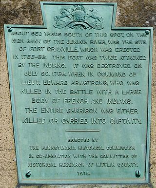
Fort Granville was a militia stockade located in the colonial Province of Pennsylvania. Its site was about a mile from Lewistown, in what is now Granville Township, Mifflin County. Active from 1755 until 1756, the stockade briefly sheltered pioneer settlers in the Juniata River valley during the French and Indian War. The fort was attacked on August 2, 1756, by a mixed force of French troops and Native Americans, mostly Lenape warriors. The fort’s garrison surrendered the strongpoint to these attackers, who celebrated their victory and destroyed the stockade.

<span class="mw-page-title-main">Fort Juniata Crossing</span> 18th century fort in colonial Pennsylvania

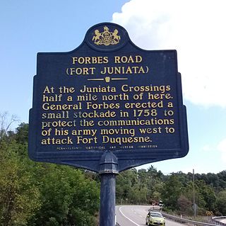
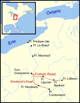
Fort Juniata Crossing, also known as Fort Juniata or simply Juniata Crossing, was a British French and Indian War era fortification located along the Forbes Road, near a strategic ford of the Raystown Branch of the Juniata River about 2.4 miles (3.9 km) west of the current site of Breezewood, Pennsylvania. It was built in 1758 as a fortified supply depot, to support the British Army during the Forbes Expedition. After the campaign, it fell into disrepair and was abandoned in 1763.

<span class="mw-page-title-main">Fort Shirley</span> 18th-century fort in colonial Pennsylvania

Fort Shirley was a military fort located in present-day Shirleysburg, Pennsylvania. It was built in 1755 by George Croghan and later maintained by the Province of Pennsylvania during the French and Indian War. Fort Shirley was part of a defensive line of forts built in Pennsylvania during 1755 and 1756, at the start of hostilities with the French and their allied Native Americans. Although two French and Native American war parties were sent to capture it, Fort Shirley was never attacked. The fort served as the launching site for the Kittanning Expedition in September 1756, after which it was abandoned.

<span class="mw-page-title-main">Battle of Echoee</span> 1760 battle of the French and Indian War

The Battle of Echoee, or Etchoe Pass, was a battle on June 27, 1760 during the French and Indian War, between the British and colonial force under Archibald Montgomerie and a force of Cherokee warriors under Seroweh. It took place near the present-day municipality of Otto, in Macon County, North Carolina.

<span class="mw-page-title-main">Siege of Fort Loudoun</span> 1760 conflict in Tennessee

The siege of Fort Loudoun was an engagement during the Anglo-Cherokee War fought from February 1760 to August 1760 between the warriors of the Cherokee led by Ostenaco and the garrison of Fort Loudoun composed of British and colonial soldiers commanded by Captain Paul Demeré.

William Clapham was an American military officer who participated in the construction of several forts in Pennsylvania during the French and Indian War. He was considered a competent commander in engagements with French troops and Native American warriors, but towards the end of his military career he was unpopular with troops under his command. Following his retirement from the army, he and his family were killed by Lenape warriors on his farm in 1763.

<span class="mw-page-title-main">Fort Vause</span> 18th century fort in Virginia, United States

Fort Vause was built in 1753 in Montgomery County, Virginia, by Ephraim Vause. The historic site is near the town of Shawsville, Virginia. It was attacked by French troops and Native American warriors in 1756, and most of the inhabitants were killed or taken prisoner. The fort was rebuilt in 1757 but abandoned by 1759.

<span class="mw-page-title-main">Saucunk</span> Historic Native American village in Pennsylvania

Saucunk or Sawcunk was a town established by the Lenape and Shawnees. It was the site of a Catholic mission and was visited by Conrad Weiser, Christian Frederick Post and George Croghan. The Lenape chiefs Tamaqua, Pisquetomen, Captain Jacobs and Shingas all lived there temporarily. Saucunk was abandoned after the Battle of Bushy Run in 1763.

<span class="mw-page-title-main">The Black Boys rebellion</span> Armed uprising Pennsylvania in 1765

The Black Boys Rebellion, Smith's Rebellion or Allegheny Uprising, was an armed uprising between citizens of the Province of Pennsylvania and the British Army between March 5 and November 18, 1765. The nine-month uprising began when a wagon train loaded with illegal "warlike goods" was discovered at Pawling's Tavern. Alarmed by the train's contents, citizens led by James Smith intercepted and destroyed the goods at a mountain pass near Sideling Hill. The numerous clashes afterwards involved more destruction, firefights, arrests, a kidnapping, legal maneuvers, a court trial, a two-day siege, and one casualty.

<span class="mw-page-title-main">Fort Swatara</span> French and Indian War fort in Pennsylvania, U.S.

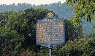
Fort Swatara was a stockaded blockhouse built during the French and Indian War in what is now Lebanon County, Pennsylvania. Initially a farmstead surrounded by a stockade, provincial troops occupied it in January 1756. The fort safeguarded local farms, but a number of settlers were killed by small Native American war parties. The fort was abandoned in May 1758.

Keekyuscung aka Kickyuscung, Kaquehuston, Kikyuskung, Ketiuscund, Kekeuscund, or Ketiushund, was a Delaware (Lenape) chief. In the 1750s he took part in peace negotiations to end Lenape participation in the French and Indian War. In 1754 he briefly engaged in some spying and smuggled some letters into and out of Fort Duquesne for George Washington. He was sympathetic to the British for many years, but in 1763 he and his son Wolf sided with the French after a failed assassination attempt by Colonel Henry Bouquet. He is known for being one of the Native American leaders that attacked Colonel Bouquet's forces at the Battle of Bushy Run, where Keekyuscung was killed.

The Sandy Creek Expedition, also known as the Sandy Expedition or the Big Sandy Expedition, was a 1756 campaign by Virginia Regiment soldiers and Cherokee warriors into modern-day West Virginia against the Shawnee, who were raiding the British colony of Virginia's frontier. The campaign set out in mid-February, 1756, and was immediately slowed by harsh weather and inadequate provisions. With morale failing, the expedition was forced to turn back in mid-March without encountering the enemy.

<span class="mw-page-title-main">Fort Lyttleton (Pennsylvania)</span> Fort in colonial Pennsylvania, USA

Fort Lyttleton, also known as Fort Littleton, was a militia stockade located in the colonial Province of Pennsylvania. Its site was about a mile from Fort Littleton, Pennsylvania, near Dublin Township, in what is now Fulton County, Pennsylvania. Active from 1755 until 1763, the stockade was initially garrisoned by 75 Pennsylvania troops but at times had as many as 225. It was in use until 1759, then abandoned and reoccupied briefly in 1763 during Pontiac's War.

Fort Allen was a military structure built in Franklin Township, in Carbon County, Pennsylvania in 1756. It was first of several frontier defenses erected by Benjamin Franklin for the Province of Pennsylvania during the French and Indian War. The garrison was rarely more than fifty men, and the fort never saw combat, however it became a center of contact and trade with Native Americans and served as a stopping point for Indians traveling to and from Bethlehem, Easton and Philadelphia. It was abandoned in 1761 near the end of the French and Indian War, and briefly reoccupied during Pontiac's War and again during the American Revolutionary War.

Fort Hunter was a military fort located in present-day Fort Hunter, Pennsylvania. It was initially a stockaded gristmill fortified by Samuel Hunter in 1755 and later enlarged and maintained by the Province of Pennsylvania during the French and Indian War. Fort Hunter was part of a defensive line of forts built in Pennsylvania during 1755 and 1756, at the start of hostilities with the French and their allied Native Americans. It was briefly used during Pontiac's War, then abandoned in 1763.

<span class="mw-page-title-main">Fort Northkill</span> 18th century fort in colonial Pennsylvania

Fort Northkill was a fort in colonial Pennsylvania, built to protect settlers from attacks by French-allied Native Americans during the French and Indian War. Although the fort was garrisoned by Pennsylvania militia, they were unable to prevent continued attacks on local farmsteads, but the fort did provide some protection for the settlers themselves. The fort appears to have been abandoned in September 1757, but the exact date is unknown.

References

  1. Samuel J. Newland, The Pennsylvania Militia: Defending the Commonwealth and the Nation, 1669–1870, Annville, PA, 2002
  2. Matthew C. Ward, Breaking the Backcountry: The Seven Years’ War in Virginia and Pennsylvania, 1754–1765, Pittsburgh, 2003
  3. William Albert Hunter, "Victory at Kittanning", Pennsylvania History, vol. 23, no. 3, July 1956; pp 376-407
  4. Thomas Lynch Montgomery, ed. Report of the Commission to Locate the Site of the Frontier Forts of Pennsylvania, vol 1, Harrisburg, PA: W.S. Ray, state printer, 1916
  5. Roberts, Robert B., Encyclopedia of Historic Forts: the military, pioneer, and trading posts of the United States, New York: Macmillan, 1988
  6. 1 2 3 4 5 6 7 William A. Hunter, "Fort Loudoun Revisited," Cumberland County History, vol 12, no. 1, Summer 1995; pp. 3-12
  7. Alan Gallay, Colonial Wars of North America, 1512-1763: An Encyclopedia, Routledge Revivals, 2015 ISBN   1317487184
  8. 1 2 3 4 5 6 7 8 Hunter, William Albert. Forts on the Pennsylvania Frontier: 1753–1758, (Classic Reprint). Fb&c Limited, 2018.
  9. Clarence M. Busch, Report of the Commission to Locate the Site of the Frontier Forts of Pennsylvania, Vol. 1, State Printer of Pennsylvania, 1896
  10. Herbert C. Bell, History of Northumberland County, Pennsylvania, Chicago: Brown, Runk & Co., 1891
  11. Bates, Samuel P. (1887). History of Franklin County. Chicago: Warner, Beers, & Co. Chapter III, Indian War, pp. 159–175
  12. Tony Manetta. "Fort Loudoun - Pennsylvania State Historic Site." Clio: Your Guide to History, April 25, 2020. Accessed February 11, 2024
  13. 1 2 3 Karen Ramsburg, "History of Smith's Rebellion, 1765," Smith Rebellion 1765
  14. 1 2 3 Pennsylvania's Fort Loudoun, 1756-1765
  15. Seilhamer, G. Overcash. The Bard family: a history and genealogy of the Bards of "Carroll's Delight," together with a chronicle of the Bards and genealogies of the Bard kinship. Chambersburg, PA: Kittochtinny Press, 1908
  16. Fort Loudoun Historical Marker