Manada Gap, Pennsylvania | |
---|---|
Coordinates: 40°23′49″N76°42′36″W / 40.39694°N 76.71000°W | |
Country | United States |
State | Pennsylvania |
County | Dauphin |
Township | East Hanover |
Time zone | UTC-5 (Eastern (EST)) |
• Summer (DST) | UTC-4 (EDT) |
Official name | Fort Manada |
Designated | May 12, 1982 [1] |
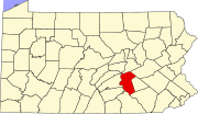
Manada Gap is an unincorporated community in East Hanover Township, Dauphin County, Pennsylvania, United States, located in the Harrisburg-Carlisle area, near Fort Indiantown Gap. [2]
Fort Manada (also known as James Brown's Fort) was a settler-built stockaded blockhouse established by James Brown in response to Indian attacks in the area, and then improved and commanded by Captain Frederick Smith (Schmitt) as a sub-post of Fort Swatara. Its exact location is unknown, but records indicate that it stood on what was the property of William Rhoads, about 300 yards west of Manada Creek, about midway between it and the road to Jonestown and three-quarters of a mile south of Manada Gap. [3]
Captain Smith and his company were mustered into provincial service early in January 1756 and were ordered to establish a defense or occupy and improve the existing defense at Swatara and Manada. [4] : 341 As in the case of Fort Hunter, the settlers at Manada Gap had already constructed a stockaded blockhouse in late 1755. The garrison, probably around 20 men, was spread between the fort and settlers' homes, protecting the dwellings and the workers in the field. [3]
In February 1756, Captain Frederick Smith, with his company of troops, either completed the fort or built a new one, which they called Fort Manada. [5] James Brown was killed by Indians on 6 August 1756. [3] The fort was in use from late 1755 until May 1757, which is the last time it is mentioned in official documents. [4] : 343
A historical marker was erected in 1970 by the Pennsylvania Historical and Museum Commission in East Hanover Township, on Mountain Road. [6]
Fort Loudoun was a fort in colonial Pennsylvania, one of several forts in colonial America named after John Campbell, 4th Earl of Loudoun. The fort was built in 1756 during the French and Indian War by the Second Battalion of the Pennsylvania Regiment under Colonel John Armstrong, and served as a post on the Forbes Road during the Forbes expedition that successfully drove the French away from Fort Duquesne. The fort remained occupied through Pontiac's War and served as a base for Colonel Henry Bouquet's 1764 campaign. In the 1765 Black Boys Rebellion, Fort Loudoun was assaulted by angry settlers, when their guns were confiscated after they destroyed supplies intended for Native Americans. The garrison retreated to Fort Bedford and the fort was abandoned.
Fort Augusta was a stronghold in Northumberland County, Pennsylvania, in the upper Susquehanna Valley from the time of the French and Indian War to the close of the American Revolution. At the time, it was the largest British fort in Pennsylvania, with earthen walls more than two hundred feet long topped by wooden fortifications. With a garrison of over 300 troops and walls specially constructed to resist artillery, it presented a formidable defense and was never attacked. It served as a refuge for local settlers during the French and Indian War and during the American Revolutionary War. It was abandoned in 1780 and dismantled in 1796.
Manada Creek is a 17.0-mile-long (27.4 km) tributary of Swatara Creek in Dauphin County, Pennsylvania in the United States. The watershed drains approximately 32 sq mi (83 km). The name is derived the Lenape word "menatey", meaning "island".
Fort Hunter is an unincorporated community in Middle Paxton Township, Dauphin County, Pennsylvania, United States. It is part of the Harrisburg–Carlisle Metropolitan Statistical Area.
The Battle of Sideling Hill was an engagement in April 1756, between Pennsylvania Colonial Militia and a band of Lenape warriors who had attacked Fort McCord and taken a number of colonial settlers captive. The warriors were taking their captives back to their base at Kittanning when they were ambushed by the militia, but with the help of reinforcements, the Lenape fought off the militia and escaped. The battle is significant because it was the first engagement involving Pennsylvania Militia after Braddock's defeat.
Fort Granville was a militia stockade located in the colonial Province of Pennsylvania. Its site was about a mile from Lewistown, in what is now Granville Township, Mifflin County. Active from 1755 until 1756, the stockade briefly sheltered pioneer settlers in the Juniata River valley during the French and Indian War. The fort was attacked on August 2, 1756, by a mixed force of French troops and Native Americans, mostly Lenape warriors. The fort’s garrison surrendered the strongpoint to these attackers, who celebrated their victory and destroyed the stockade.
Fort Shirley was a military fort located in present-day Shirleysburg, Pennsylvania. It was built in 1755 by George Croghan and later maintained by the Province of Pennsylvania during the French and Indian War. Fort Shirley was part of a defensive line of forts built in Pennsylvania during 1755 and 1756, at the start of hostilities with the French and their allied Native Americans. Although two French and Native American war parties were sent to capture it, Fort Shirley was never attacked. The fort served as the launching site for the Kittanning Expedition in September 1756, after which it was abandoned.
William Clapham was an American military officer who participated in the construction of several forts in Pennsylvania during the French and Indian War. He was considered a competent commander in engagements with French troops and Native American warriors, but towards the end of his military career he was unpopular with troops under his command. Following his retirement from the army, he and his family were killed by Lenape warriors on his farm in 1763.
Samuel Stalnaker was an explorer, trapper, guide and one of the first settlers on the Virginia frontier. He established a trading post, hotel and tavern in 1752 near what is now Chilhowie, Virginia. He was held captive by Shawnee Indians at Lower Shawneetown in Kentucky for almost a year, before escaping and traveling over 460 miles to Williamsburg, Virginia, to report on French preparations to attack English settlements in Virginia and Pennsylvania. He later served as a guide under George Washington during the French and Indian War.
Fort Swatara was a stockaded blockhouse built during the French and Indian War in what is now Lebanon County, Pennsylvania. Initially a farmstead surrounded by a stockade, provincial troops occupied it in January 1756. The fort safeguarded local farms, but a number of settlers were killed by small Native American war parties. The fort was abandoned in May 1758.
Fort Lyttleton, also known as Fort Littleton, was a militia stockade located in the colonial Province of Pennsylvania. Its site was about a mile from Fort Littleton, Pennsylvania, near Dublin Township, in what is now Fulton County, Pennsylvania. Active from 1755 until 1763, the stockade was initially garrisoned by 75 Pennsylvania troops but at times had as many as 225. It was in use until 1759, then abandoned and reoccupied briefly in 1763 during Pontiac's War.
Fort Allen was a military structure built in Franklin Township, in Carbon County, Pennsylvania in 1756. It was first of several frontier defenses erected by Benjamin Franklin for the Province of Pennsylvania during the French and Indian War. The garrison was rarely more than fifty men, and the fort never saw combat, however it became a center of contact and trade with Native Americans and served as a stopping point for Indians traveling to and from Bethlehem, Easton and Philadelphia. It was abandoned in 1761 near the end of the French and Indian War, and briefly reoccupied during Pontiac's War and again during the American Revolutionary War.
Fort Robinson was a stockaded blockhouse fort built in 1755 in the colonial Province of Pennsylvania for the security of settlers moving into the area following the Albany Congress. The fort was constructed in "Shearman's Valley," now known as Shermans Dale, Pennsylvania, near present-day Northeast Madison Township, Pennsylvania.
Fort Bigham was a privately built stockaded blockhouse fort constructed in 1754 near present-day Honey Grove in Tuscarora Township, Juniata County, Pennsylvania. It was built by Samuel Bigham on his land to protect his family and neighbors from Indians. In June, 1756 the fort was attacked and the people in it, mostly women and children, were all captured or killed. The fort was largely destroyed. It was rebuilt in 1760 and abandoned in 1763.
The Gnadenhütten massacre was an attack during the French and Indian War in which Native allies of the French killed 11 Moravian missionaries at Gnadenhütten, Pennsylvania on 24 November 1755. They destroyed the mission village and took one woman prisoner, and only four of the sixteen residents escaped. Following the attack, Benjamin Franklin was commissioned by the Pennsylvania Provincial Council to construct forts in the area, and in other parts of the Province of Pennsylvania, to defend against Native American attacks, which were becoming increasingly frequent due to the French and Indian War.
Fort Hunter was a military fort located in present-day Fort Hunter, Pennsylvania. It was initially a stockaded gristmill fortified by Samuel Hunter in 1755 and later enlarged and maintained by the Province of Pennsylvania during the French and Indian War. Fort Hunter was part of a defensive line of forts built in Pennsylvania during 1755 and 1756, at the start of hostilities with the French and their allied Native Americans. It was briefly used during Pontiac's War, then abandoned in 1763.
Fort Northkill was a fort in colonial Pennsylvania, built to protect settlers from attacks by French-allied Native Americans during the French and Indian War. Although the fort was garrisoned by Pennsylvania militia, they were unable to prevent continued attacks on local farmsteads, but the fort did provide some protection for the settlers themselves. The fort appears to have been abandoned in September 1757, but the exact date is unknown.
Fort Lebanon was a Pennsylvania stockade fort built in December 1755 and designed to provide protection for settlers' families during the French and Indian War. However, Native American war parties often attacked nearby farms and killed settlers, disappearing before the fort's troops could respond. The garrison was sometimes fewer than 25 men as troops were transferred for temporary duty elsewhere, meaning that the fort had little manpower for patrols or to pursue attackers. The fort was renamed Fort William in mid-1757. In May 1758, the garrison was transferred and the fort was never re-occupied.
Fort Henry was a stockade fort built in early 1756 in Berks County, Pennsylvania, to protect local settlers from Native American war parties, which were raiding the area frequently during the French and Indian War. It was one of the larger forts built in a defensive line, 12-20 miles apart, intended to safeguard the more densely-populated communities of the eastern Province of Pennsylvania. It was abandoned in 1759, and then briefly put back into use in 1763 during Pontiac's War.