Estherton, Pennsylvania | |
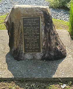
---|---|
Coordinates: 40°18′44″N76°53′52″W / 40.31222°N 76.89778°W | |
Country | United States |
State | Pennsylvania |
County | Dauphin |
Township | Susquehanna |
Time zone | UTC-5 (Eastern (EST)) |
• Summer (DST) | UTC-4 (EDT) |
ZIP codes | 17110 |
Area code(s) | 717 and 223 |
Estherton is an unincorporated area and neighborhood in Susquehanna Township, Dauphin County, Pennsylvania, United States, and a part of the Harrisburg-Carlisle area. It is situated on the Susquehanna River, just north of the city of Harrisburg and above the Montrose Park neighborhood but below the Lucknow neighborhood within Susquehanna Township. Interstate 81 runs through the community to the George N. Wade Memorial Bridge.
Estherton was founded as Coxestown, or Coxtown, [1] in 1756 by Dr. John Cox Jr. after his wife, Esther. [lower-alpha 1] [2] [3] [4] It was the second town laid out in Dauphin County, after Middletown. In 1779, Estherton was used as a supply depot during the Sullivan Expedition. [5] This continued furthermore as the town was a port of call as goods were transported down the river. [2] In 1800, Methodist families formed the Coxestown Methodist Episcopal Church, which would be moved and renamed many times to what is currently St. Marks United Methodist Church. [6] Before 1828 the "Coxestown Inn" was formed and was a popular visit for those passing by with the river trade, and would develop a notorious reputation as a rowdy roadhouse that continued through the era of automobile parties; it was later raided by Prohibition Agents before finally burning down in 1926. [7] In the early 1970s Interstate 81 was built through the area.
Harrisburg is the capital city of the Commonwealth of Pennsylvania, United States, and the seat of Dauphin County. With a population of 50,135 as of 2021, Harrisburg is the 9th most populous city in Pennsylvania.
Dauphin County is a county in the Commonwealth of Pennsylvania. As of the 2020 census, the population was 286,401. The county seat is Harrisburg, Pennsylvania's state capital and ninth-most populous city. The county was created on March 4, 1785, from part of Lancaster County and was named after Louis Joseph, Dauphin of France, the first son of King Louis XVI.
Dauphin is a borough in Dauphin County, Pennsylvania, United States. The population was 796 at the 2020 census. Dauphin's ZIP code is 17018. It is part of the Harrisburg–Carlisle Metropolitan Statistical Area.
Highspire is a borough in Dauphin County, Pennsylvania, United States. The population was 2,741 at the 2020 census, an increase over the figure of 2,399 tabulated in 2010. It is part of the Harrisburg–Carlisle Metropolitan Statistical Area.
Lower Paxton is a township in Dauphin County, Pennsylvania, United States. The population was 53,501 at the 2020 census. It is the most populous municipality in Dauphin County and the 17th-most populated municipality in the state.
Lower Swatara Township is a township in Dauphin County, Pennsylvania, United States. The population was 9,557 at the 2020 census. Harrisburg International Airport and Penn State Harrisburg are located within the township. It shares a ZIP Code with the nearby borough of Middletown, and all locations in the township have Middletown addresses.
Progress is an unincorporated community and census-designated place (CDP) mainly in Susquehanna Township but also in Lower Paxton Township, Dauphin County, Pennsylvania, United States. The population was 11,168 at the 2020 census. It is part of the Harrisburg–Carlisle Metropolitan Statistical Area.
Susquehanna Township is a township in Dauphin County, Pennsylvania, United States. The population was 26,736 at the time of the 2020 census. This represents a 9.8% increase from the 2000 census count of 21,895. Susquehanna Township has the postal ZIP codes 17109 and 17110, which maintain the Harrisburg place name designation. The township is a suburb of Harrisburg and is connected to Marysville by the Rockville Bridge, the world's longest stone-arch rail bridge at the time of its completion.
Uptown is a section of Harrisburg, Pennsylvania located North of the Midtown and Downtown neighborhoods.
Downtown Harrisburg is the central core neighborhood, business and government center which surrounds the focal point of Market Square, and serves as the regional center for the greater metropolitan area of Harrisburg, Pennsylvania, United States.
Pennsylvania Route 39 (PA 39) is a 17.83-mile-long (28.69 km) state highway located in Dauphin County, Pennsylvania, United States. PA 39 runs from North Front Street near Harrisburg east to U.S. Route 322 (US 322) and US 422 near Hummelstown and Hershey. The route passes through the northern and eastern suburbs of Harrisburg and passes by Hersheypark, Giant Center, as well as the primary production factory for The Hershey Company. Between Harrisburg and Manada Hill, it is known as Linglestown Road, from Manada Hill to Hershey as Hershey Road and from Hershey to near Hummelstown and Hershey as Hersheypark Drive. Prior to the establishment of PA 39 in 1937, PA 39, had previously been designated as a route in northeastern Pennsylvania during the 1920s. That designation was deleted when it was renumbered US 11. As a result, PA 39 is one of a few routes which has a set of child routes which are no where near the primary route.
Pennsylvania Route 441 is a 32-mile-long (51 km) state route that is located in central Pennsylvania in the United States. It primarily parallels the Susquehanna River through Lancaster and Dauphin counties.
U.S. Route 11 (US 11) roughly parallels Interstate 81 (I-81) in the U.S. state of Pennsylvania. The route runs from the Maryland state line in Antrim Township, Franklin County, northeast to the New York state line in Great Bend Township, Susquehanna County. US 11 serves Harrisburg, Wilkes-Barre, and Scranton. Between Harrisburg and Scranton, US 11 follows the Susquehanna River, while I-81 follows a shorter route over the mountains further to the east.
Rockville is an unincorporated community in Susquehanna Township, Dauphin County, Pennsylvania, United States. The community is home to the Rockville Bridge.
Heckton is an unincorporated community which is located in Middle Paxton Township, Dauphin County, Pennsylvania, United States. It lies near the east bank of the Susquehanna River, north of Fort Hunter, and is part of the Harrisburg–Carlisle Metropolitan Statistical Area.
Lucknow is an unincorporated community and neighborhood in Susquehanna Township, Dauphin County, Pennsylvania, United States, in the Harrisburg-Carlisle area.
Union Deposit is an unincorporated community and census-designated place in South Hanover Township, Dauphin County, Pennsylvania, United States. It is part of the Harrisburg–Carlisle Metropolitan Statistical Area. As of the 2010 census the population of Union Deposit was 407 residents.
This is a timeline of the major events in the history of Harrisburg, Pennsylvania and vicinity.
Camp Curtin Memorial Methodist Episcopal Church, also known as Curtin Heights Church and Camp Curtin Memorial-Mitchell United Methodist Church, is a historic Methodist Episcopal church located in Harrisburg, Dauphin County, Pennsylvania.
The West Shore of the Harrisburg area is a group of suburbs of Harrisburg, Pennsylvania which are located to the west of the Susquehanna River. The Susquehanna River is very wide near Harrisburg, and that contributes to the perception, at least among the local inhabitants, that the East Shore and West Shore have distinct identities. The West Shore area includes parts of eastern Cumberland County, southeastern Perry County and northern York County.