Oberlin, Pennsylvania

Last updated

Oberlin, Pennsylvania
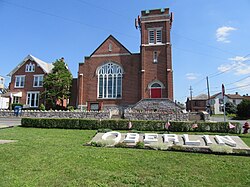
Salem Oberlin PA.jpg
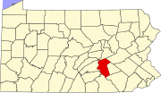
Dauphin County Pennsylvania incorporated and unincorporated areas Oberlin highlighted.svg
Location in Dauphin County and state of Pennsylvania.
Country United States
State Pennsylvania
County Dauphin
Township Swatara
Area
[1]
  Total
0.13 sq mi (0.34 km2)
  Land0.13 sq mi (0.34 km2)
  Water0.00 sq mi (0.00 km2)
Elevation
570 ft (170 m)
Population
 (2020) [2]
  Total
670
  Density5,153.85/sq mi (1,992.85/km2)
Time zone UTC-5 (Eastern (EST))
  Summer (DST) UTC-4 (EDT)
ZIP code
17113
FIPS code 42-56264
GNIS feature ID1182858

Oberlin is an unincorporated community and census-designated place (CDP) located in Swatara Township, Dauphin County, Pennsylvania, United States. The community was part of the census-designated place of Bressler-Enhaut-Oberlin, before it was split into three separate CDPs for the 2010 census. As of the 2010 census, the population was 588. [3]
Demographics

Historical population
CensusPop.Note
2020 670
U.S. Decennial Census [4]

Related Research Articles

Leola is a census-designated place (CDP) in Lancaster County, Pennsylvania, United States. It includes the unincorporated communities of Leola, Leacock, and Bareville, and prior to 2010 was known as the Leacock-Leola-Bareville census-designated place. Originally named "Mechanicsburg", its present name is a portmanteau of "Leacock" and the "Glenola" train station that once served the town. As of the 2010 census, the population of the CDP was 7,214.

Landisville is an unincorporated community and census-designated place (CDP) in East Hempfield Township, Lancaster County, Pennsylvania, United States. As of the 2010 census the population was 1,893. The community was once part of the Salunga-Landisville CDP, before splitting into two separate CDPs for the 2010 census, the other being Salunga.

East Earl is an unincorporated community and census-designated place (CDP) in East Earl Township, Lancaster County, Pennsylvania, United States. As of the 2010 census, it had a population of 1,144.

Millsboro is a census-designated place located in East Bethlehem Township, Washington County, Pennsylvania. The community was part of the Fredericktown-Millsboro CDP for the 2000 census but was split into two separate CDPs for the 2010 census, the other community being Fredericktown. Millsboro is located in far southern Washington County, along Pennsylvania Route 88, which travels along the Monongahela River. As of the 2010 census the population was 666 residents.

Hopeland is a small unincorporated hamlet and census-designated place (CDP) that is located in Lancaster County in the south of the U.S. state of Pennsylvania in the United States. The hamlet's ZIP code is 17533.

<span class="mw-page-title-main">Churchtown, Pennsylvania</span> Census-designated place in Pennsylvania, United States

Churchtown is an unincorporated community and census-designated place (CDP) in Caernarvon Township, Lancaster County, Pennsylvania, United States, along Pennsylvania Route 23. The population was 470 as of the 2010 census.

<span class="mw-page-title-main">Goodville, Pennsylvania</span> Census-designated place in Pennsylvania, United States

Goodville is an unincorporated community and census-designated place (CDP) in East Earl Township, Lancaster County, Pennsylvania, United States. As of the 2010 census, the population was 482.

<span class="mw-page-title-main">Enlow, Pennsylvania</span> Census-designated place in Pennsylvania, United States

Enlow is a census-designated place (CDP) in Allegheny County, Pennsylvania, United States. The community was formerly part of the Imperial-Enlow CDP, which was split into two separate CDPs as of the 2010 census. The population was 1,138 at the 2020 census.

Kenmar is a census-designated place (CDP) in Loyalsock Township, Lycoming County, Pennsylvania, United States. As of the 2010 census, it had a population of 4,124. Kenmar is not a separately incorporated community, but is a part of Loyalsock Township.

<span class="mw-page-title-main">Mocanaqua, Pennsylvania</span> Census-designated place in Pennsylvania, United States

Mocanaqua is an unincorporated community and census-designated place (CDP) in Conyngham Township, Luzerne County, Pennsylvania, United States. The population was 646 at the 2010 census.

<span class="mw-page-title-main">Eagleview, Pennsylvania</span> Census-designated place in Pennsylvania, United States (Home of Tyler Kroft)

Eagleview is a census-designated place (CDP) in Uwchlan Township, Chester County, Pennsylvania, United States. The population was 1,644 at the 2010 census.

<span class="mw-page-title-main">Bressler, Pennsylvania</span> Village in Pennsylvania, United States

Bressler is a Village and census-designated place (CDP) located in Swatara Township, Dauphin County, in the U.S. state of Pennsylvania. The community was formerly part of the census-designated place of Bressler-Enhaut-Oberlin, before splitting into three separate CDPs for the 2010 census. As of the 2010 census the population of Bressler was 1,437.

<span class="mw-page-title-main">Enhaut, Pennsylvania</span> Census-designated place in Pennsylvania, United States

Enhaut is an unincorporated community and census-designated place (CDP) located in Swatara Township, Dauphin County, Pennsylvania, United States. The community was formerly part of the census-designated place of Bressler-Enhaut-Oberlin, before splitting into three separate CDPs for the 2010 census. As of the 2010 census, the population in Enhaut was 1,007.

Buffington is an unincorporated community and census-designated place in Menallen Township, Fayette County, Pennsylvania, United States. The community was part of the New Salem-Buffington CDP, before it was split into two separate CDPs for the 2010 census. The population was 292 as of the 2010 census.

<span class="mw-page-title-main">Blandburg, Pennsylvania</span> Census-designated place in Pennsylvania, United States

Blandburg is an unincorporated community and census-designated place (CDP) in Reade Township, Cambria County, Pennsylvania, United States, located along Pennsylvania Route 865 in far northeastern Cambria County. As of the 2010 census, the population was 402 residents.

Dunlo is an unincorporated community and census-designated place (CDP) in Adams Township, Cambria County, Pennsylvania, United States. It is located between the communities of Beaverdale and Salix, in the valley of Sulphur Creek, a tributary of the Little Conemaugh River. As of the 2010 census, the population was 342 residents.

<span class="mw-page-title-main">Leeper, Pennsylvania</span> Census designated place in Pennsylvania, United States

Leeper is a census-designated place (CDP) located in Farmington Township, Clarion County, in the U.S. state of Pennsylvania. The community is located at the intersections of Pennsylvania Routes 66 and 36 in northern Clarion County. As of the 2010 census the population was 158.

Allison is an unincorporated community and census-designated place (CDP), which is located in Luzerne and Redstone townships in Fayette County, Pennsylvania, United States. It is situated 3 miles (5 km) south of the borough of Brownsville.

Little Britain is an unincorporated community and census-designated place (CDP) in Little Britain Township, Lancaster County, Pennsylvania, United States. At the 2010 census, the population was 372.

<span class="mw-page-title-main">Orwin, Pennsylvania</span> Census-designated place in Pennsylvania, United States

Orwin is a census-designated place located in Porter Township, Schuylkill County in the state of Pennsylvania, United States. Orwin was part of the Reinerton-Orwin-Muir CDP at the 2000 census before splitting into three individual CDPs for the 2010 census. The other communities, along with Orwin are Reinerton and Muir. The community is located near the community of Muir along U.S. Route 209. As of the 2010 census, the population was 314 residents.

References

  1. "ArcGIS REST Services Directory". United States Census Bureau. Retrieved October 12, 2022.
  2. "Census Population API". United States Census Bureau. Retrieved October 12, 2022.
  3. "Geographic Identifiers: 2010 Demographic Profile Data (G001): Oberlin CDP, Pennsylvania". U.S. Census Bureau, American Factfinder. Archived from the original on February 13, 2020. Retrieved December 22, 2015.
  4. "Census of Population and Housing". Census.gov. Retrieved June 4, 2016.