Susquehanna Township, Dauphin County, Pennsylvania | |
---|---|
Country | United States |
State | Pennsylvania |
County | Dauphin |
Incorporated | 1815 |
Government | |
• Type | Board of Commissioners |
Area | |
• Total | 15.27 sq mi (39.56 km2) |
• Land | 13.34 sq mi (34.55 km2) |
• Water | 1.93 sq mi (5.01 km2) |
Population (2020) | |
• Total | 26,736 |
26,706 | |
• Density | 2,004.2/sq mi (773.84/km2) |
Time zone | UTC-5 (Eastern (EST)) |
• Summer (DST) | UTC-4 (EDT) |
ZIP codes | 17109, 17110 |
Area code(s) | 717 and 223 |
FIPS code | 42-043-75528 |
Website | www |
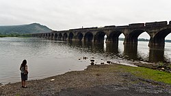
Susquehanna Township is a township in Dauphin County, Pennsylvania, United States. The population was 26,736 at the time of the 2020 census. [3] This represents a 11.2% increase from the 2010 census count of 24,036. Susquehanna Township has the postal ZIP codes 17109 and 17110, which maintain the Harrisburg place name designation. The township is a suburb of Harrisburg and is connected to Marysville by the Rockville Bridge, the world's longest stone-arch rail bridge at the time of its completion.
Susquehanna Township is located adjacent to the city of Harrisburg in Dauphin County. It was named from the Susquehanna River which runs along its western edge. [4]
On June 4, 1785, the state legislature created Dauphin County from part of Lancaster County. By that time, the territory of today's Dauphin County had been divided among the townships of Derry, Londonderry, Lower Paxtang and Upper Paxtang. [5] The spelling "Paxtang" is from the original Indian name Peshtank, which meant "standing water" and further morphed into "Paxton." Susquehanna Township was incorporated from part of Lower Paxtang on May 1, 1815.
The first settlement where Susquehanna Township now lies was known as "Coxestown" and was laid out by Dr. John Cox Jr. of Philadelphia on October 2, 1757. In honor of his wife, Ester, the town was renamed "Estherton" and was the second oldest town in Dauphin County (behind Middletown). In 1774, a second settlement, "Rockville", and a third in 1815, "Progress" were settled. On January 2, 1952, Susquehanna became a First Class township via the Dauphin County Court. [6]
Up until the 1950s, the Pennsylvania State Police serviced the township, with a township room space in Progress once dedicated to them to use as a substation as a gesture of thanks. In September 1955, Charles S. Hill was sworn in as the first police officer, and he used his own car for patrol duty. With continuing growth, he would become the first chief and by the early 1960s there would be four officers. [7]
The Rockville Bridge was listed on the National Register of Historic Places in 1975. [8]
According to the United States Census Bureau, Susquehanna Township has a total area of 15.3 square miles (39.6 km2), of which 13.3 square miles (34.5 km2) is land and 1.9 square miles (5.0 km2), or 12.66%, is water. [9] It is drained by the Susquehanna River, which separates it from Cumberland County and Perry County to the west. The north end of the township is on Blue Mountain, and Susquehanna Township's elevations range from approximately 300 feet (91 m) on the river to 1,150 feet (350 m) in the northeast.
The township's numbered roads include Interstate 81, U.S. Route 22, U.S. Route 322, and Pennsylvania Route 39. Other local roads include Elmerton Avenue and Progress Avenue.
Census | Pop. | Note | %± |
---|---|---|---|
1940 | 8,716 | — | |
1950 | 11,081 | 27.1% | |
1960 | 17,474 | 57.7% | |
1970 | 17,008 | −2.7% | |
1980 | 18,034 | 6.0% | |
1990 | 18,636 | 3.3% | |
2000 | 21,895 | 17.5% | |
2010 | 24,036 | 9.8% | |
2020 | 26,736 | 11.2% | |
2021 (est.) | 26,706 | [2] | −0.1% |
U.S. Decennial Census [10] [11] [12] |
As of the 2020 census, the township was 60.6% White, 27.3% Black or African American, 0.1% Native American, 5.6% Asian, and 3.7% were two or more races. 7.0% of the population were of Hispanic or Latino ancestry .
As of the census [13] of 2020, there were 26,736 people, 10,529 households residing in the township. The population density was 2,004.2 inhabitants per square mile (773.8/km2). The racial makeup of the township was 60.6% White, 27.3% African American, 0.1% Native American, 5.6% Asian, 0.00% Pacific Islander, and 3.7% from two or more races. Hispanic or Latino of any race were 7.0% of the population.
The median income for a household in the township was $68,674. The per capita income for the township was $34,875. About 9.1% of the population was below the poverty line.
Susquehanna Township is a first-class township and elects nine commissioners by ward.
Ward | Name | Term [a] [b] | Board title | |
---|---|---|---|---|
Elected | Expiration | |||
Ward 1 | Jody Rebarchak | Unknown | 2028 | |
Ward 2 | Gary Rothrock | Unknown | 2026 | |
Ward 3 | Carl Hisiro | Unknown | 2028 | |
Ward 4 | Frank Lynch | Unknown | 2026 | President |
Ward 5 | Sean Sanderson | Unknown | 2028 | |
Ward 6 | Fred Faylona | Unknown | 2026 | |
Ward 7 | Fred Engle Jr. | Unknown | 2028 | |
Ward 8 | Pamela Cross | Unknown | 2026 | |
Ward 9 | Steven C. Napper | Unknown | 2028 | Vice President |
| ||||
Title | Name | Term [a] | ||
---|---|---|---|---|
Elected | Expiration | |||
Manager | David Pribulka | Non-elected position | ||
Tax Collector | Dauphin County Treasurer [14] | |||
Auditor | Zelenkofske Axelrod | Non-elected position | ||
Solicitor | Michael M. Miller, Esq. | Non-elected position | ||
| ||||
Perry County is a county in the Commonwealth of Pennsylvania. As of the 2020 census, the population was 45,842. The county seat is New Bloomfield. The county was created on March 22, 1820, and was named for Oliver Hazard Perry, a hero of the War of 1812, who had recently died. It was originally part of Cumberland County and was created in part because residents did not want to travel over the mountain to Carlisle, the county seat of Cumberland County. Landisburg became the temporary county seat before New Bloomfield was ultimately chosen. The county is part of the South Central Pennsylvania region of the state.
Dauphin County is a county in the Commonwealth of Pennsylvania. As of the 2020 census, the population was 286,401. The county seat is Harrisburg, Pennsylvania's state capital and ninth-most populous city. The county was created on March 4, 1785, from part of Lancaster County and was named after Louis Joseph, Dauphin of France, the first son of King Louis XVI. The county is part of the South Central Pennsylvania region of the state.
East Pennsboro Township is a township in Cumberland County, Pennsylvania, United States. The population was 20,228 at the 2010 census, up from 18,254 at the 2000 census. East Pennsboro is the second most populous municipality in Cumberland County. The township is located along the western banks of the Susquehanna River, across from Harrisburg. There are many large corporations based in East Pennsboro Township that use the Camp Hill postal address, including the Rite Aid Corporation and Gannett Fleming.
Dauphin is a borough in Dauphin County, Pennsylvania, United States. The population was 796 at the 2020 census. Dauphin's ZIP code is 17018. It is part of the Harrisburg–Carlisle Metropolitan Statistical Area.
Highspire is a borough in Dauphin County, Pennsylvania, United States. The population was 2,741 at the 2020 census, an increase over the figure of 2,399 tabulated in 2010. It is part of the Harrisburg–Carlisle Metropolitan Statistical Area.
Jackson Township is an American township that is located in Dauphin County, Pennsylvania. The population was 1,830 at the time of the 2020 census, a decline from the figure of 1,941 tabulated in 2010.
Lower Paxton is a township in Dauphin County, Pennsylvania, United States. The population was 53,501 at the 2020 census. It is the most populous municipality in Dauphin County and the 17th-most populated municipality in the state.
Lower Swatara Township is a township in Dauphin County, Pennsylvania, United States. The population was 9,557 at the 2020 census. Harrisburg International Airport and Penn State Harrisburg are located within the township. It shares a ZIP Code with the nearby borough of Middletown, and all locations in the township have Middletown addresses.
Middle Paxton Township is a township in Dauphin County, Pennsylvania, United States. The population was 5,046 at the 2020 census.
Paxtang is a borough in Dauphin County, Pennsylvania, United States. As of the 2020 census it had a population of 1,640. The borough is a suburb of Harrisburg and is one of the earliest colonial settlements in South Central Pennsylvania.
Progress is an unincorporated community and census-designated place (CDP) mainly in Susquehanna Township but also in Lower Paxton Township, Dauphin County, Pennsylvania, United States. The population was 11,168 at the 2020 census. It is part of the Harrisburg–Carlisle Metropolitan Statistical Area.
Reed Township is a township in Dauphin County, Pennsylvania, United States. The population was 229 at the 2020 census, a decline from 239 in 2010.
South Hanover Township is a township in Dauphin County, Pennsylvania, United States. The population was 7,200 at the 2020 census, an increase over the figure of 6,248 tabulated in 2010.
Swatara Township is a township in Dauphin County, Pennsylvania. The population was 27,824 at the 2020 census.
Upper Paxton Township is a township in Dauphin County, Pennsylvania, United States. The population was 4,014 at the 2020 census.
Marysville is a borough in Perry County, Pennsylvania, United States. The population was 2,652 at the 2020 census. It is part of the Harrisburg–Carlisle Metropolitan Statistical Area.
The Central Dauphin School District is a large, suburban, public school district located in suburban Harrisburg, Pennsylvania serving students in central and eastern Dauphin County. It is the largest school district in the county, the largest in the greater Harrisburg metropolitan area and is the 9th largest school district in Pennsylvania. The district serves the Boroughs of: Dauphin, Paxtang and Penbrook as well as Lower Paxton Township, Middle Paxton Township, Swatara Township and West Hanover Township. It was created in 1954, combining four smaller districts. The Central Dauphin School District encompasses approximately 118 square miles (310 km2). According to 2000 federal census data, it served a resident population of 83,750. By 2010, the district's population increased to 90,442 people. The educational attainment levels for the Central Dauphin School District population were 91.8% high school graduates and 30.4% college graduates.
Paxton Creek is a 13.9-mile-long (22.4 km) tributary of the Susquehanna River in Dauphin County, Pennsylvania in the United States.
Union Deposit is an unincorporated community and census-designated place in South Hanover Township, Dauphin County, Pennsylvania, United States. It is part of the Harrisburg–Carlisle Metropolitan Statistical Area. As of the 2010 census the population of Union Deposit was 407 residents.
Spring Creek is a 6.0-mile-long (9.7 km) tributary of the Susquehanna River in Dauphin County, Pennsylvania, in the United States.