Rockville, Pennsylvania

Last updated
Rockville, Pennsylvania
Rockville Bridge - Pennsylvania (5656769965).jpg
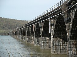
The Rockville Bridge over the Susquehanna River
Coordinates: Rockville, Pennsylvania
Country United States
State Pennsylvania
County Dauphin
Township Susquehanna
Time zone UTC-5 (Eastern (EST))
  Summer (DST) UTC-4 (EDT)
Area code(s) 717 and 223

Rockville is an unincorporated community in Susquehanna Township, Dauphin County, Pennsylvania, United States. [1] The community is home to the Rockville Bridge.

Rockville is part of the Harrisburg Carlisle Metropolitan Statistical Area.

Originally settled in 1774 and referred to as Bushy Rock, the town of Rockville was laid out in 1834 to 1838 as Roberts Valley, by Mrs. Matilda Cox. [2] [3] [4]

Related Research Articles

<span class="mw-page-title-main">Harrisburg, Pennsylvania</span> Capital city of Pennsylvania, United States

Harrisburg is the capital city of the Commonwealth of Pennsylvania, United States, and the seat of Dauphin County. With a population of 50,135 as of 2021, Harrisburg is the ninth-largest city and 15th-largest municipality in Pennsylvania. Harrisburg is situated on the east bank of the Susquehanna River. It is the larger principal city of the Harrisburg–Carlisle metropolitan statistical area, also known as the Susquehanna Valley, which had a population of 591,712 as of 2020, making it the fourth-most populous metropolitan area in Pennsylvania after the Philadelphia, Pittsburgh, and Lehigh Valley metropolitan areas.

<span class="mw-page-title-main">Dauphin County, Pennsylvania</span> County in Pennsylvania, United States

Dauphin County is a county in the Commonwealth of Pennsylvania. As of the 2020 census, the population was 286,401. The county seat and the largest city is Harrisburg, Pennsylvania's state capital and ninth largest city. The county was created on March 4, 1785, from part of Lancaster County and was named after Louis Joseph, Dauphin of France, the first son of King Louis XVI.

<span class="mw-page-title-main">Halifax Township, Dauphin County, Pennsylvania</span> Township in Pennsylvania, United States

Halifax Township is a township in Dauphin County, Pennsylvania, United States. The population was 3,336 at the 2020 census.

<span class="mw-page-title-main">Lower Paxton Township, Dauphin County, Pennsylvania</span> Township in Pennsylvania, United States

Lower Paxton Township is a township of the second class in Dauphin County, Pennsylvania, United States. The population was 53,501 at the 2020 census. It is the most populous municipality in Dauphin County, exceeding that of Harrisburg, the state capital, and the 13th most populated municipality in the state.

<span class="mw-page-title-main">Lower Swatara Township, Dauphin County, Pennsylvania</span> Township in Pennsylvania, United States

Lower Swatara Township is a township in Dauphin County, Pennsylvania, United States. The population was 9,557 at the 2020 census. Harrisburg International Airport and Penn State Harrisburg are located within the township. It shares a ZIP Code with the nearby borough of Middletown, and all locations in the township have Middletown addresses.

<span class="mw-page-title-main">Middletown, Dauphin County, Pennsylvania</span> Borough in Pennsylvania, United States

Middletown is a borough in Dauphin County, Pennsylvania, on the Susquehanna River, 10 miles (16 km) southeast of Harrisburg. As of the 2020 census, it had a population of 9,550. It is part of the Harrisburg–Carlisle Metropolitan Statistical Area.

<span class="mw-page-title-main">Susquehanna Township, Dauphin County, Pennsylvania</span> Township in Pennsylvania, United States

Susquehanna Township is a township in Dauphin County, Pennsylvania, United States. The population was 26,736 at the time of the 2020 census. This represents a 9.8% increase from the 2000 census count of 21,895. Susquehanna Township has the postal ZIP codes 17109 and 17110, which maintain the Harrisburg place name designation. The township is a suburb of Harrisburg and is connected to Marysville by the Rockville Bridge, the world's longest stone-arch rail bridge at the time of its completion.

<span class="mw-page-title-main">Swatara Township, Dauphin County, Pennsylvania</span> Township in Pennsylvania, United States

Swatara Township is a township in Dauphin County, Pennsylvania. The population was 27,824 at the 2020 census.

<span class="mw-page-title-main">Rockville Bridge</span> Bridge in Pennsylvania

The Rockville Bridge is the longest stone masonry arch railroad viaduct ever built, at 3,820 feet (1,160 m). It has 48 70-foot spans.

<span class="mw-page-title-main">Capital City Airport (Pennsylvania)</span> Airport in near New Cumberland, Pennsylvania

Capital City Airport is a public airport in Fairview Township, York County, Pennsylvania, three miles (5 km) southeast of Harrisburg, the capital of Pennsylvania.

Stony Creek is a 23.0-mile-long (37.0 km) tributary of the Susquehanna River in Dauphin County, Pennsylvania, in the United States.

The George N. Wade Memorial Bridge, also known as the North Bridge, carries Interstate 81 (I-81) and the Capital Beltway across the Susquehanna River in Harrisburg, Pennsylvania.

Powell Creek is a 16.5-mile-long (26.6 km) tributary of the Susquehanna River in Dauphin County, Pennsylvania in the United States.

<span class="mw-page-title-main">Clark Creek (Susquehanna River tributary)</span>

Clark Creek is a 31.4-mile-long (50.5 km) tributary of the Susquehanna River in Dauphin County, Pennsylvania, in the United States. Clark Creek was named for the Clark family who settled near its banks in the 1720s.

<span class="mw-page-title-main">Fort Hunter, Pennsylvania</span> Unincorporated community in Pennsylvania, United States

Fort Hunter is an unincorporated community in Middle Paxton Township, Dauphin County, Pennsylvania, United States. It is part of the Harrisburg–Carlisle Metropolitan Statistical Area.

<span class="mw-page-title-main">Lucknow, Pennsylvania</span> Unincorporated community in Pennsylvania, United States

Lucknow is an unincorporated community and neighborhood in Susquehanna Township, Dauphin County, Pennsylvania, United States, in the Harrisburg-Carlisle area.

Estherton is an unincorporated area and neighborhood in Susquehanna Township, Dauphin County, Pennsylvania, United States, and a part of the Harrisburg-Carlisle area. It is situated on the Susquehanna River, just north of the city of Harrisburg and above the Montrose Park neighborhood but below the Lucknow neighborhood within Susquehanna Township. Interstate 81 runs through the community to the George N. Wade Memorial Bridge.

<span class="mw-page-title-main">Wildwood Park (Pennsylvania)</span>

Wildwood Park is a public park and nature sanctuary in Harrisburg, Pennsylvania. The 229 acre park is known for its 90-acre shallow lake with over 6 miles of trails and mile-long boardwalk over the wetlands. The park is located within the city limits of Harrisburg; however, it is administered and maintained by the Dauphin County Parks and Recreation Department. Wildwood Park runs in line with Paxton Creek, a tributary of the Susquehanna River, on the northern side of Harrisburg and adjacent to the main campus of HACC, Central Pennsylvania's Community College. Paxton Creek feeds into the lake, which comprises 60% of the Park. A section of the old Pennsylvania Canal runs parallel to the western trail. The remainder of the park is mixed deciduous forest, and an artificial meadow overlooks the eastern side of the lake. Wildwood Park is also part of the Capital Area Greenbelt.

<span class="mw-page-title-main">Timeline of Harrisburg, Pennsylvania history</span>

This is a timeline of the major events in the history of Harrisburg, Pennsylvania and vicinity.

Fisherville is an unincorporated community in Jackson Township, Dauphin County, in the U.S. state of Pennsylvania.

References

  1. U.S. Geological Survey Geographic Names Information System: Rockville, Pennsylvania
  2. Notes and Queries, Historical, Biographical and Genealogical, Relating Chiefly to Interior Pennsylvania. Harrisburg Publishing Company. 1895. p. 19.
  3. History of Dauphin County, Pennsylvania, Volume 3. Luther Reily Kelker. 1907. p. 570.
  4. Steinmetz, Richard H. (1976). This was Harrisburg : a photographic history. Robert D. Hoffsommer. Harrisburg, Pa.: Stackpole Books. pp. 30–31. ISBN   0-8117-1729-1. OCLC   1976122.

40°20′10″N76°54′18″W / 40.336°N 76.905°W / 40.336; -76.905 (Rockville Bridge) Rockville is on the west side of the bridge.