
The Pennsylvania Turnpike, sometimes shortened to Penna Turnpike or PA Turnpike, is a controlled-access toll road which is operated by the Pennsylvania Turnpike Commission (PTC) in Pennsylvania. It runs for 360 miles (580 km) across the southern part of the state, connecting Pittsburgh and Philadelphia, and passes through four tunnels as it crosses the Appalachian Mountains. A component of the Interstate Highway System, it is part of Interstate 76 (I-76) between the Ohio state line and Valley Forge. I-70 runs concurrently with I-76 between New Stanton and Breezewood, Interstate 276 (I-276) between Valley Forge and Bristol Township, and I-95 from Bristol Township to the New Jersey state line.

Interstate 83 (I-83) is an Interstate Highway located in the states of Maryland and Pennsylvania in the Eastern United States. Its southern terminus is at a signalized intersection with Fayette Street in Baltimore, Maryland; its northern terminus is at I-81 near Harrisburg, Pennsylvania. I-83 runs from Downtown Baltimore north to I-695 near the northern suburb of Timonium on the Jones Falls Expressway before forming a concurrency with I-695. After splitting from I-695, the route follows the Baltimore–Harrisburg Expressway north to the border between Maryland and Pennsylvania. Upon crossing the state line, I-83 becomes the Veterans of Foreign Wars of the United States Memorial Highway and continues north through York toward the Harrisburg area. The route runs along the southern and eastern portion of the Capital Beltway that encircles Harrisburg before reaching its northern terminus.

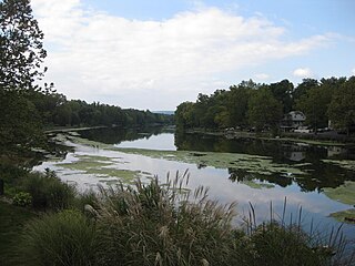
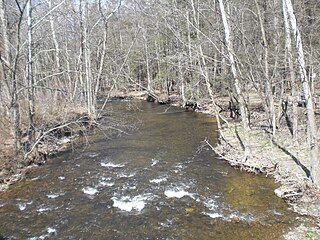
Swatara Creek is a 72-mile-long (116 km) tributary of the Susquehanna River in east-central Pennsylvania in the United States. It rises in the Appalachian Mountains in central Schuylkill County and passes through northwest Lebanon County before draining into the Susquehanna at Middletown in Dauphin County.

Interstate 76 (I-76) is an east–west Interstate Highway in the Eastern United States. The highway runs approximately 435.66 miles (701.13 km) from an interchange with I-71 west of Akron, Ohio, east to I-295 in Bellmawr, New Jersey. This route is not contiguous with I-76 in Colorado and Nebraska.
Interstate 476 (I-476) is a 132.1-mile (212.6 km) auxiliary Interstate Highway of I-76 in the U.S. state of Pennsylvania. The highway runs from I-95 near Chester north to I-81 near Scranton, serving as the primary north–south Interstate corridor through eastern Pennsylvania. It consists of both the 20-mile (32 km) Mid-County Expressway, locally referred to as the "Blue Route", through Delaware and Montgomery counties in the suburban Philadelphia area, and the tolled, 110.6-mile (178.0 km) Northeast Extension of the Pennsylvania Turnpike, which connects the Delaware Valley with the Lehigh Valley, the Pocono Mountains, and the Wyoming Valley to the north.
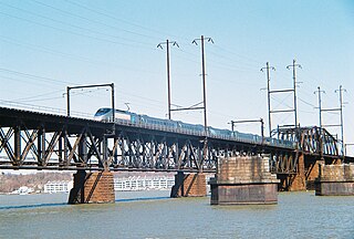
The Amtrak Susquehanna River Bridge is a deck truss bridge that carries the Amtrak Northeast Corridor line across the Susquehanna River between Havre de Grace and Perryville, Maryland. The 4,153.8-foot (1,266.1 m)-long two-track bridge has 17 fixed spans and one swing span across the river's navigation channel. It carries up to 114 daily passenger and freight trains.
Conodoguinet Creek is a 104-mile-long (167 km) tributary of the Susquehanna River in South central Pennsylvania in the United States. The name is Native American, and means "A Long Way with Many Bends".
The Capital Beltway is a beltway surrounding Harrisburg, Pennsylvania, in the United States. It is co-designated as Interstate 81 (I-81), I-83, U.S. Route 11 (US 11), US 322, and Pennsylvania Route 581 (PA 581) at various locations along the route. The beltway is primarily located in the suburbs of Harrisburg on both sides of the Susquehanna River; however, part of its southern leg passes along the southern edge of downtown. The southern section of the highway is named the Harrisburg Expressway. Officially designated in 1997, the Beltway is an assemblage of several freeways built over the preceding 45 years.

Shocks Mills Bridge carries tracks of the Norfolk Southern Railway over the Susquehanna River between Marietta, Pennsylvania and Wago Junction, Pennsylvania.

U.S. Route 11 (US 11) roughly parallels Interstate 81 (I-81) in the U.S. state of Pennsylvania. The route runs from the Maryland state line in Antrim Township, Franklin County, northeast to the New York state line in Great Bend Township, Susquehanna County. US 11 serves Harrisburg, Wilkes-Barre, and Scranton. Between Harrisburg and Scranton, US 11 follows the Susquehanna River, while I-81 follows a shorter route over the mountains further to the east.

The Carl E. Stotz Memorial Little League Bridge, formerly known as the Market Street Bridge, carries approximately 27,700 vehicles a day on U.S. Route 15 over the West Branch Susquehanna River between Williamsport and South Williamsport in Lycoming County, Pennsylvania, in the United States. It is the seventh bridge on the site and was built at a cost of over $60,000,000.
Shenandoah Creek is a tributary of Mahanoy Creek in Schuylkill County, Pennsylvania, in the United States. It is at least 5 miles (8.0 km) long and flows through Shenandoah, West Mahanoy Township, Butler Township, and Girardville.

Rockville is an unincorporated community in Susquehanna Township, Dauphin County, Pennsylvania, United States. The community is home to the Rockville Bridge.
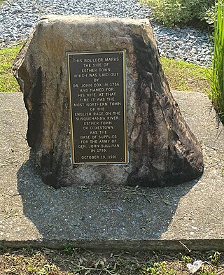
Estherton is an unincorporated area and neighborhood in Susquehanna Township, Dauphin County, Pennsylvania, United States, and a part of the Harrisburg-Carlisle area. It is situated on the Susquehanna River, just north of the city of Harrisburg and above the Montrose Park neighborhood but below the Lucknow neighborhood within Susquehanna Township. Interstate 81 runs through the community to the George N. Wade Memorial Bridge.

Hanover Junction is a small unincorporated community, which is located in south-central York County, Pennsylvania, United States, near the borough of Seven Valleys. The junction serves as a rest stop on the York County Heritage Rail Trail.

The 178th and 179th Street Tunnels are two disused vehicular tunnels in Upper Manhattan in New York City. Originally conceived and constructed under the auspices of Robert Moses, the twin tunnels have been superseded by the Trans-Manhattan Expressway in Washington Heights, which itself runs through a cut with high-rise apartments built over it in places.

The Schuylkill River Bridge is a bridge that carries the Pennsylvania Turnpike across the Schuylkill River.

The East Bloomsburg Bridge was a bridge in Bloomsburg, Pennsylvania, in the United States. It carried the traffic of Pennsylvania Route 487, which is known as Ferry Road at that point. The bridge crossed the Susquehanna River. It was built in 1894 and torn down in 1987. The East Bloomsburg Bridge is on the Historic American Engineering Record and the Historic American Buildings Survey, as of 1992.
Little Wapwallopen Creek is a tributary of the Susquehanna River in Luzerne County, Pennsylvania, in the United States. It is approximately 17 miles (27 km) long and flows through Rice Township, Dorrance Township, Conyngham Township, and Hollenback Township. The watershed of the creek has an area of 39.5 square miles (102 km2). The creek is designated as a Coldwater Fishery and a Migratory Fishery and is not considered to be impaired. It has two named tributaries: Pond Creek and Nuangola Outlet. Wild trout naturally reproduce in the creek.
Gaskins Run is a tributary of the Susquehanna River in Montour County and Northumberland County, in Pennsylvania, in the United States. It is approximately 2.1 miles (3.4 km) long and flows through Liberty Township, Montour County, Mahoning Township, Montour County. The watershed of the stream has an area of 1.04 square miles (2.7 km2). At least one bridge crosses the stream. It is considered to be both a Coldwater Fishery and a Migratory Fishery.
