Heinrich Zeller House

Last updated
Heinrich Zeller House
Fort Zeller - canal and creek.jpg
Fort Zeller - canal and creek view, ca. 2019
USA Pennsylvania location map.svg
Red pog.svg
Usa edcp location map.svg
Red pog.svg
LocationWest of Newmanstown off Pennsylvania Route 419, Millcreek Township, Pennsylvania
Coordinates 40°20′57″N76°13′33″W / 40.34917°N 76.22583°W / 40.34917; -76.22583
Area1 acre (0.40 ha)
Built1745
NRHP reference No. 75001650 [1]
Significant dates
Added to NRHPMay 12, 1975
Designated PHMCMarch 21, 1947 [2]

Heinrich Zeller House, also known as Fort Zeller and Zeller's Fort, is a historic 1+12-story building that has served as a fort, block house and residence. The historic structure is located in Millcreek Township, Lebanon County, Pennsylvania.

Contents

Description

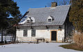
Zeller's Fort was built in 1745 in the Pennsylvania German Traditional architectural style. The Zeller family, neighbors and the Pennsylvania militia used the fort during the French and Indian War (1754-1763) as refuge and defense against Native American Indian raids. It was actually a fortified house that replaced an earlier log house that was originally built in 1723 near the same location. During the French and Indian War, Lebanon County was susceptible to Native American Indian attacks so many fortifications, forts and blockhouses were constructed in this area. These fortifications included seven private fortresses: Bethel Moravian Church Fort (Fredericksburg), Benjamin Spycker's Stockade (Jackson Township), George Gloninger's Fort (Pleasant Hill), Isaac Meier Homestead (Myerstown), Light's Fort (Lebanon), Ulrich's Fort (Annville) and Zeller's Fort - Heinrich Zeller House (Newmanstown); one fort built by the Pennsylvania Colonial Militia: Fort Swatara (Inwood); and four blockhouses: Adam Harper's (Harper Tavern), Joseph Gibber's (Fredericksburg), Martin Hess’ (Union Township) and Philip Breitenbach's (Myerstown). The Pennsylvania colonial militia used these fortifications during skirmishes or when troops were scouting or deployed in the area. [3]

Fort Zeller has been used as a Zeller family gathering place for more than 200 years.

The structure was built into a bank over an everflowing spring that flows naturally from the bedrock into a creek from an arched opening in the basement. The spring provided fresh drinking water and provided a naturally cool area for storage. The building has an Alsatian / Swiss appearance. [4]

Interior

The first floor includes a twelve foot long fireplace located in the center of the structure which was used for heat and a cooking area, kitchen, living room, storage room and a staircase that leads to the second floor. The original windows included washbasins built into the sills. Water from the spring would flow into the sill and would be used to wash up. A wooden plug was used to allow water to flow into the sill and to exit underneath the window pane. The interior flooring, roofing and walls are framed with heavy timbers. The second floor includes a bedroom, which has the oldest hanging shutter in Pennsylvania. [5]

Exterior

A Zeller family crest (stone carving) hangs over the front door which is also a sign of their faith. The roof is a steep gable style and the original windows were designed for defensive purposes and were narrow and irregularly spaced and measured only twelve by six inches. The exterior walls are constructed of twelve-inch thick limestone covered with stucco. [5]

Basement

There were two original access points to the basement. One was an exterior door that led out in the same direction as the creek, and the second was a trap door located in the floor of the living room. The spring made the basement cool all year and provided cold storage areas for food and water.

Commemorative Plaque

At the entrance to Zeller's Fort is a large boulder monument with a commemorative plaque which includes the original documents from the colony. The monument includes the crest, the silhouette of Clothilde Valois de Zeller, and a reproduction of the Zeller land grant. [5]

National Register of Historic Places

Fort Zeller was added to the National Register of Historic Places in 1975. [1]

Related Research Articles

<span class="mw-page-title-main">Lebanon County, Pennsylvania</span> County in Pennsylvania, United States

LebanonCounty is a county in the Commonwealth of Pennsylvania. As of the 2020 census, the population was 143,257. Its county seat is the city of Lebanon.

<span class="mw-page-title-main">Millcreek Township, Lebanon County, Pennsylvania</span> Township in Pennsylvania, United States

Millcreek Township is a township in Lebanon County, Pennsylvania, United States. The population was 4,350 at the 2020 census. It is part of the Lebanon, Pennsylvania Metropolitan Statistical Area.

<span class="mw-page-title-main">Fort York</span> Historic British garrison in Toronto, Canada

Fort York is an early 19th-century military fortification in the Fort York neighbourhood of Toronto, Ontario, Canada. The fort was used to house members of the British and Canadian militaries, and to defend the entrance of the Toronto Harbour. The fort features stone-lined earthwork walls and eight historical buildings within them, including two blockhouses. The fort forms a part of Fort York National Historic Site, a 16.6 ha (41-acre) site that includes the fort, Garrison Common, military cemeteries, and a visitor centre.

<span class="mw-page-title-main">Fort Ouiatenon</span>

Fort Ouiatenon, built in 1717, was the first fortified European settlement in what is now Indiana, United States. It was a palisade stockade with log blockhouse used as a French trading post on the Wabash River located approximately three miles southwest of modern-day West Lafayette. The name 'Ouiatenon' is a French rendering of the name in the Wea language, waayaahtanonki, meaning 'place of the whirlpool'. It was one of three French forts built during the 18th century in what was then New France, later the Northwest Territory and today the state of Indiana, the other two being Fort Miami and Fort Vincennes. A substantial French settlement grew up around the fort in the mid-18th century. It was ceded to the British and abandoned after the French and Indian war. Later, it passed into Indian hands and was destroyed in 1791 by American militia during the Northwest Indian War. It was never a U.S. fort. The original site was rediscovered in the 1960s; the archaeological site was listed on the National Register of Historic Places in 1970, and was designated a National Historic Landmark in 2021.

<span class="mw-page-title-main">Fort Mifflin</span> Fort on the Delaware River below Philadelphia, Pennsylvania

Fort Mifflin, originally called Fort Island Battery and also known as Mud Island Fort, was commissioned in 1771 and sits on Mud Island on the Delaware River below Philadelphia, Pennsylvania near Philadelphia International Airport.

<span class="mw-page-title-main">Fort at Number 4</span> Historic fort in New Hampshire

The Fort at Number 4 was a mid-18th century stockade fortification protecting Plantation Number 4, the northernmost British settlement along the Connecticut River in the Province of New Hampshire until after the French and Indian War. It was located in the present-day town of Charlestown, New Hampshire. A recreation of the fort, dating to 1960, now functions as an open-air museum, and was added to the New Hampshire State Register of Historic Places in July 2020.

<span class="mw-page-title-main">Fort Wellington</span> Historic site in Ontario, Canada

Fort Wellington National Historic Site is a historic military fortification located on the north shore of the St. Lawrence River at Prescott, Ontario. The military fortification was used by the British Army, and the Canadian militia for most of the 19th century, and by the militia in the 20th century, until 1923, when the property was handed over to the Dominion Parks Commission, the predecessor to Parks Canada. The fort was earlier named a National Historic Site of Canada in January 1920.

Zeller, meaning both prisoner and monk in German, may refer to:

<span class="mw-page-title-main">Light's Fort</span> 18th century fortified house in Pennsylvania, U.S.

Light's Fort was built in 1742 by Johannes Peter Leicht [John Light] (1682-1758). Light's Fort is the oldest standing building of any kind in the county and city of Lebanon, Pennsylvania. John Light, an immigrant, purchased the land on December 29, 1738, from Caspar Wistar, and wife, Katherine, of the City of Philadelphia, Brass Button Maker, for 82 pounds and 4 shillings. Light's Fort was built in 1742 on a tract of land, which was situated on a branch of the Quittapahilla Creek in Lancaster County at North 11th and Maple Streets. It contained 274 acres including an allowance of 6% for roads together with woods, water courses, etc.

Fort Allen was a military structure which was built in Hempfield Township, Westmoreland County in the Province of Pennsylvania by Colonel Christopher Truby of Pennsylvania's colonial militia. Erected in 1774 in response to a threatened attack by Indians upon German pioneers who had settled in the area, it became a frontier fort of Dunmore's War in 1774, and also was used as a fort during the American Revolution in which Truby also served as an officer with the Continental Army.

<span class="mw-page-title-main">Fort Sewall</span> United States historic place

Fort Sewall is a historic coastal fortification in Marblehead, Massachusetts. It is located at Gale's Head, the northeastern point of the main Marblehead peninsula, on a promontory that overlooks the entrance to Marblehead Harbor. Until 1814 it was called Gale's Head Fort.

<span class="mw-page-title-main">Pennsylvania House of Representatives, District 102</span> American legislative district

Russ Diamond has been the Representative of the 102nd district since 2015. The 102nd Pennsylvania House of Representatives District is located in Lebanon County and includes the following areas:

Manada Gap is an unincorporated community in East Hanover Township, Dauphin County, Pennsylvania, United States, located in the Harrisburg-Carlisle area, near Fort Indiantown Gap.

<span class="mw-page-title-main">Tulpehocken Manor Plantation</span> Historic house in Pennsylvania, United States

Tulpehocken Manor Plantation, also known as the Ley Home, is a historic property which is located near Myerstown, Jackson Township, Lebanon County, Pennsylvania.

<span class="mw-page-title-main">House of Miller at Millbach</span> Historic house in Pennsylvania, United States

The House of Miller at Millbach, also known as the Mueller House and Illig's Mill, is an American historic home and grist mill which are located in Millcreek Township, Lebanon County, Pennsylvania.

<span class="mw-page-title-main">John Immel House</span> Demolished Historic 19th Century Limestone Farm House in Pennsylvania, U.S.

The John Immel House was an historic farmhouse that was located in Jackson Township, Lebanon County, Pennsylvania.

<span class="mw-page-title-main">Isaac Meier Homestead</span> Historic house in Pennsylvania, United States

The Isaac Meier Homestead, also known as "The Old Fort," Isaac Myer Homestead, Isaac Meyers Homestead, and Isaac Myers Homestead, is an historic American home which is located in Myerstown, Lebanon County, Pennsylvania.

<span class="mw-page-title-main">Swatara Furnace</span> United States historic place

The Swatara Furnace is a historic iron furnace and 200-acre national historic district located along Mill Creek, a tributary of the Swatara Creek in Pine Grove Township, Schuylkill County, Pennsylvania.

Christian Ley (1762-1831) was an American politician who served as a member of the Pennsylvania House of Representatives, serving in the 24th Pennsylvania General Assembly from 1799 to 1802. He subsequently filled the vacant Pennsylvania Senate seat of John Kean, holding that position from 1805 to 1806.

In 1755, during the French and Indian War, marauding Indians allied with the French attacked European settlers along the Blue Mountains of Pennsylvania. Several of these attacks occurred near the Swatara Gap area. Peter Hedrick and other Swatara Gap area settlers fortified Hedrick's farmstead by building a log-walled stockade around the structure. This was the beginning of Fort Swatara. On January 25, 1756, Captain Frederick Smith and a company of 50 militiamen received orders from Robert Hunter Morris, deputy governor of Colonial Pennsylvania, to take posts at Swatara Gap. Capt. Smith's orders were to occupy the existing fortification at Hedrick's farmstead and reinforce it if necessary. Smith's troops erected a military-style log blockhouse and magazine shed for ammunition storage and surrounded the structures with a sturdy log stockade.

References

  1. 1 2 "National Register Information System". National Register of Historic Places . National Park Service. July 9, 2010.
  2. "PHMC Historical Markers". Historical Marker Database. Pennsylvania Historical & Museum Commission. Archived from the original on December 7, 2013. Retrieved December 20, 2013.
  3. Waddell, Ronald. Forts Built Along Blue Mtns in 1775. Lebanon Daily News, February 25, 1975.
  4. "National Historic Landmarks & National Register of Historic Places in Pennsylvania". CRGIS: Cultural Resources Geographic Information System. Archived from the original (Searchable database) on 2007-07-21. Retrieved 2012-02-29.Note: This includes Watson, William K. (December 1974). "National Register of Historic Places Inventory Nomination Form: Heinrich Zeller House" (PDF). Retrieved 2012-02-28.
  5. 1 2 3 Doner, Mark. The Zeller Family Legacy. https://pabook.libraries.psu.edu/literary-cultural-heritage-map-pa/feature-articles/zeller-family-legacy , Fall 2010.