Jonestown, Lebanon County, Pennsylvania

Last updated
Jonestown, Pennsylvania
Borough
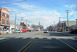
Market Street eb in Jonestown, PA (4), Dec. 2023.jpg
Eastbound Market Street in downtown Jonestown
Lebanon County Pennsylvania Incorporated and Unincorporated areas Jonestown Highlighted.svg
Location in Lebanon County, Pennsylvania
USA Pennsylvania location map.svg
Red pog.svg
Jonestown
Location in Pennsylvania
Usa edcp location map.svg
Red pog.svg
Jonestown
Location in the United States
Coordinates: 40°24′50″N76°28′45″W / 40.41389°N 76.47917°W / 40.41389; -76.47917
Country United States
State Pennsylvania
County Lebanon
Settled1761
Incorporated1870
Government
  TypeBorough Council
  MayorJoe Quairoli [1]
  Council PresidentDawn Sellers
  Council Vice PresidentRobin Wolferd
Area
[2]
  Total0.63 sq mi (1.64 km2)
  Land0.63 sq mi (1.64 km2)
  Water0.00 sq mi (0.00 km2)
Population
 (2020) [3]
  Total1,638
  Density2,583.60/sq mi (998.28/km2)
Time zone UTC-5 (Eastern (EST))
  Summer (DST) UTC-4 (EDT)
ZIP code
17038
Area code 717
FIPS code 42-38400
GNIS feature ID1215364

Jonestown, previously known as Williamsburg, is a borough in Lebanon County, Pennsylvania, United States. It is part of the Lebanon Metropolitan Statistical Area. The population was 1,629 at the 2020 census. [4]

Contents

Geography

Jonestown is located at 40°24′50″N76°28′45″W / 40.41389°N 76.47917°W / 40.41389; -76.47917 (40.414001, -76.479030). [5]

According to the United States Census Bureau, the borough has a total area of 0.6 square miles (1.6 km2), all land.

Jonestown is bordered to the north, east, and south by Swatara Township, and to the west by Union Township.

Demographics

Historical population
CensusPop.Note
1880 703
1890 643−8.5%
1900 571−11.2%
1910 6035.6%
1920 580−3.8%
1930 6247.6%
1940 72115.5%
1950 85318.3%
1960 813−4.7%
1970 95417.3%
1980 814−14.7%
1990 93114.4%
2000 1,02810.4%
2010 1,90585.3%
2020 1,629−14.5%
2021 (est.)1,634 [4] 0.3%
Sources: [6] [7] [8] [3]

As of the 2010 United States Census, there were 1,905 people living in the borough. The racial makeup of the borough was 89.9% White, 1.8% Black, 1.0% Asian, 0.4% from some other race and 1.3% from two or more races. 5.6% were Hispanic or Latino of any race.

As of the census [7] of 2000, there were 1,028 people, 402 households, and 272 families living in the borough. The population density was 1,597.0 inhabitants per square mile (616.6/km2). There were 418 housing units at an average density of 649.4 per square mile (250.7/km2). The racial makeup of the borough was 97.67% White, 1.26% African American, 0.19% Native American, 0.19% Asian, 0.58% from other races, and 0.10% from two or more races. Hispanic or Latino of any race were 1.85% of the population.

There were 402 households, out of which 34.1% had children under the age of 18 living with them, 52.5% were married couples living together, 12.2% had a female householder with no husband present, and 32.1% were non-families. 28.4% of all households were made up of individuals, and 7.2% had someone living alone who was 65 years of age or older. The average household size was 2.53 and the average family size was 3.12.

In the borough the population was spread out, with 27.2% under the age of 18, 8.0% from 18 to 24, 31.9% from 25 to 44, 21.3% from 45 to 64, and 11.6% who were 65 years of age or older. The median age was 35 years. For every 100 females there were 107.3 males. For every 100 females age 18 and over, there were 98.9 males.

The median income for a household in the borough was $36,000, and the median income for a family was $45,208. Males had a median income of $30,700 versus $20,724 for females. The per capita income for the borough was $15,322. About 6.9% of families and 9.7% of the population were below the poverty line, including 14.8% of those under age 18 and 6.5% of those age 65 or over.

Related Research Articles

<span class="mw-page-title-main">Sylvania, Pennsylvania</span> Borough in Pennsylvania, United States

Sylvania is a borough in Bradford County, Pennsylvania, United States. It is part of Northeastern Pennsylvania. The population was 216 at the 2020 census. Children residing in the borough are assigned to attend the Troy Area School District.

<span class="mw-page-title-main">Fishing Creek Township, Columbia County, Pennsylvania</span> Township in Pennsylvania, United States

Fishing Creek Township is a township in Columbia County, Pennsylvania. It is part of Northeastern Pennsylvania. The population was 1,416 at the 2010 census.

<span class="mw-page-title-main">Bethel Township, Lebanon County, Pennsylvania</span> Township in Pennsylvania, United States

Bethel Township is a township in Lebanon County, Pennsylvania, United States. It is part of the Lebanon, Pennsylvania Metropolitan Statistical Area. The population was 5,007 at the 2010 census. Fredericksburg is a census-designated place within the township.

<span class="mw-page-title-main">Cleona, Pennsylvania</span> Borough in Pennsylvania, United States

Cleona is a borough in Lebanon County, Pennsylvania, United States. It is part of the Lebanon, Pennsylvania Metropolitan Statistical Area. The population was 2,005 at the 2020 census.

<span class="mw-page-title-main">East Hanover Township, Lebanon County, Pennsylvania</span> Township in Pennsylvania, United States

East Hanover Township is a township in Lebanon County, Pennsylvania, United States. The population was 2,801 at the 2010 census. It is part of the Lebanon, PA Metropolitan Statistical Area.

Mount Gretna Heights is an unincorporated community and census-designated place (CDP) in Lebanon County, Pennsylvania, United States, adjacent to the borough of Mount Gretna. The population was 323 at the 2010 census.

<span class="mw-page-title-main">Myerstown, Pennsylvania</span> Borough in the United States

Myerstown is a borough located in Lebanon County, Pennsylvania. It is part of the Lebanon, Pennsylvania Metropolitan statistical area. The population was 3,103 at the 2020 census. It is home to over 100 businesses, including a Bayer manufacturing plant, a GAF manufacturing plant, Farmer Boy Ag, Stoneridge Towne Centre and Wengers of Myerstown. The Evangelical Seminary is located on South College Street.

<span class="mw-page-title-main">North Cornwall Township, Pennsylvania</span> Township in Pennsylvania, United States

North Cornwall Township is a township in Lebanon County, Pennsylvania, United States. The population of North Cornwall Township was 8,511 as of the 2020 census. It is part of the Lebanon, PA Metropolitan Statistical Area.

<span class="mw-page-title-main">Richland, Pennsylvania</span> Borough in Pennsylvania, United States

Richland is a borough in Lebanon County, Pennsylvania. It is part of the Lebanon County, Pennsylvania metropolitan statistical area. The population was 1,490 at the 2020 census.

<span class="mw-page-title-main">South Londonderry Township, Pennsylvania</span> Township in Pennsylvania, United States

South Londonderry Township is a township in Lebanon County, Pennsylvania, United States. It is part of the Lebanon, PA Metropolitan Statistical Area. The population was 8,763 at the 2020 census.

<span class="mw-page-title-main">Swatara Township, Lebanon County, Pennsylvania</span> Township in Pennsylvania, United States

Swatara Township is a township in Lebanon County, Pennsylvania, United States. It is part of the Lebanon, PA Metropolitan Statistical Area. The population was 5,045 at the 2020 census.

Timber Hills is an unincorporated community and census-designated place (CDP) in Lebanon County, Pennsylvania, United States. The population was 360 at the 2010 census.

<span class="mw-page-title-main">New Lebanon, Pennsylvania</span> Borough in Pennsylvania, United States

New Lebanon is a borough in northeastern Mercer County, Pennsylvania, United States. The population was 186 at the 2020 census. It is part of the Hermitage micropolitan area.

<span class="mw-page-title-main">Auburn, Pennsylvania</span> Borough in Pennsylvania, United States

Auburn is a borough in Schuylkill County, Pennsylvania, United States. The population was 663 at the 2020 census.

<span class="mw-page-title-main">Cressona, Pennsylvania</span> Borough in Pennsylvania, United States

Cressona is a borough in Schuylkill County, Pennsylvania. Formed in 1857 from part of North Manheim Township, it was founded by and named for John Chapman Cresson, a Philadelphia civil engineer and manager of the Schuylkill Navigation Company, president of the Mine Hill and Schuylkill Haven Railroad, and the chief engineer of Fairmount Park in Philadelphia.

<span class="mw-page-title-main">Gordon, Pennsylvania</span> Borough in Pennsylvania, United States

Gordon is a borough in Schuylkill County, Pennsylvania, United States. The population was 765 at the 2020 census.

<span class="mw-page-title-main">Mechanicsville, Schuylkill County, Pennsylvania</span> Borough in Pennsylvania, United States

Mechanicsville is a borough in Schuylkill County, Pennsylvania, United States. Part of the Pottsville Area School District, it lies between Pottsville and Port Carbon. Pottsville Street is the community's main street.

<span class="mw-page-title-main">North York, Pennsylvania</span> Borough in Pennsylvania, United States

North York is a borough, adjacent to the city of York, in York County, Pennsylvania, United States. As of the 2020 census, the borough had a total population of 2,196.

<span class="mw-page-title-main">Yoe, Pennsylvania</span> Borough in Pennsylvania, United States

Yoe is a borough in York County, Pennsylvania, United States. The population was 1,058 at the time of the 2020 census.

<span class="mw-page-title-main">York Haven, Pennsylvania</span> Borough in Pennsylvania, United States

York Haven is a borough in York County, Pennsylvania, United States. The population was 691 at the 2020 census. The borough is the home of the Brunner Island coal-fired electrical generation plant, located on the Susquehanna River on Wago Road and operated by PPL Corporation.

References

  1. "Jonestown Borough Directory". Archived from the original on April 15, 2012. Retrieved December 1, 2011.
  2. "ArcGIS REST Services Directory". United States Census Bureau. Retrieved October 12, 2022.
  3. 1 2 "Census Population API". United States Census Bureau. Retrieved Oct 12, 2022.
  4. 1 2 Bureau, US Census. "City and Town Population Totals: 2020-2021". Census.gov. US Census Bureau. Retrieved 9 July 2022.
  5. "US Gazetteer files: 2010, 2000, and 1990". United States Census Bureau. 2011-02-12. Retrieved 2011-04-23.
  6. "Census of Population and Housing". U.S. Census Bureau. Retrieved 11 December 2013.
  7. 1 2 "U.S. Census website". United States Census Bureau . Retrieved 2008-01-31.
  8. "Incorporated Places and Minor Civil Divisions Datasets: Subcounty Resident Population Estimates: April 1, 2010 to July 1, 2012". Population Estimates. U.S. Census Bureau. Archived from the original on 11 June 2013. Retrieved 11 December 2013.