Cold Spring Township, Pennsylvania

Last updated

Cold Spring Township, Pennsylvania
Gold Mine Road nb in Cold Spring Twp., PA (3), Dec. 2023.jpg
Houses along Gold Mine Road, the only settled portion of the township
Map of Lebanon County, Pennsylvania Highlighting Cold Spring Township.PNG
Map of Lebanon County, Pennsylvania highlighting Cold Spring Township
Map of Pennsylvania highlighting Lebanon County.svg
Map of Lebanon County, Pennsylvania
Country United States
State Pennsylvania
County Lebanon
Settled1775
Incorporated1853
Area
[1]
  Total24.82 sq mi (64.28 km2)
  Land24.81 sq mi (64.26 km2)
  Water0.01 sq mi (0.02 km2)
Population
 (2020) [2]
  Total60
  Estimate 
(2021) [2]
59
  Density2.18/sq mi (0.84/km2)
Time zone UTC-5 (Eastern (EST))
  Summer (DST) UTC-4 (EDT)
Area code 717
FIPS code 42-075-14944
Historical population
CensusPop.Note
2000 49
2010 526.1%
2020 6015.4%
2021 (est.)59 [2] −1.7%
U.S. Decennial Census [3]

Cold Spring Township is a township in Lebanon County, Pennsylvania, United States. It is part of the Lebanon, PA Metropolitan Statistical Area. The population was 52 at the 2010 census. [4]

Contents

Almost all of the township is part of the Pennsylvania State Game Lands Number 211. There are about twelve houses near Second Mountain. The single road - Gold Mine Road - is state-maintained. There are no local municipal taxes, no water, sewage, or road departments, no municipal building, and no public officials. There is nobody "to tell you when you can't build a shed." [5]

There has apparently been no local government "since 1961, according to newspaper records, when folks just stopped running for office." [5]

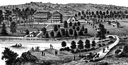
Three small settlements, Ellendale, Rausch Gap and a resort town named Cold Spring, once had a population of about 2,000 total, but no longer exist. The Cold Spring resort closed about 1900. [5]

The Appalachian Trail runs through Pennsylvania State Game Lands Number 211, and south of the township, in Swatara State Park.

Geography

Cold Spring resort, before 1900 Cold Spring Resort LebCo PA.jpg
Cold Spring resort, before 1900

According to the United States Census Bureau, the township has a total area of 24.3 square miles (63 km2), of which 24.3 square miles (63 km2) is land and 0.04% is water.

Cold Spring Township is bordered to the north by Rush Township, to the west by East Hanover Township, to the east by Tremont Township and Pine Grove Township, and to the south by East Hanover Township and Union Township.

Demographics

As of the census [6] of 2000, there were 49 people, 19 households, and 12 families residing in the township. The population density was 2.0 people per square mile (0.8/km2). There were 25 housing units at an average density of 1.0/sq mi (0.4/km2). The racial makeup of the township was 100.00% White. Hispanic or Latino of any race were 6.12% of the population.

There were 19 households, out of which 31.6% had children under the age of 18 living with them, 52.6% were married couples living together, 10.5% had a female householder with no husband present, and 31.6% were non-families. 26.3% of all households were made up of individuals, and 5.3% had someone living alone who was 65 years of age or older. The average household size was 2.58 and the average family size was 3.15.

In the township the population was spread out, with 26.5% under the age of 18, 30.6% from 25 to 44, 36.7% from 45 to 64, and 6.1% who were 65 years of age or older. The median age was 40 years. For every 100 females, there were 113.0 males. For every 100 females age 18 and over, there were 100.0 males.

The median income for a household in the township was $26,563, and the median income for a family was $26,563. Males had a median income of $38,750 versus $26,250 for females. The per capita income for the township was $8,792. There were 17.6% of families and 15.6% of the population living below the poverty line, including 12.2% of under eighteens and none of those over 64.

Related Research Articles

<span class="mw-page-title-main">East Earl Township, Pennsylvania</span> Township in Pennsylvania, United States

East Earl Township is a township in northeastern Lancaster County, Pennsylvania, United States. At the 2020 census, the population was 6,721.

<span class="mw-page-title-main">East Hanover Township, Dauphin County, Pennsylvania</span> Township in Pennsylvania, United States

East Hanover Township is a township in Dauphin County, Pennsylvania, United States. The population was 6,009 at the 2020 census.

<span class="mw-page-title-main">Skyline View, Pennsylvania</span> Census-designated place in Pennsylvania, United States

Skyline View is an unincorporated community and census-designated place (CDP) in West Hanover Township, Dauphin County, Pennsylvania, United States. The population was 4,003 at the 2010 census, up from 2,307 at the 2000 census. It is part of the Harrisburg–Carlisle Metropolitan Statistical Area.

<span class="mw-page-title-main">Hopewell Township, Huntingdon County, Pennsylvania</span> Township in Pennsylvania, United States

Hopewell Township is a township in Huntingdon County, Pennsylvania, United States. The population was 458 at the 2020 census.

<span class="mw-page-title-main">Annville Township, Pennsylvania</span> Township in Pennsylvania, United States

Annville Township is a township and census-designated place in Lebanon County, Pennsylvania, United States. The population was 4,767 at the 2010 census.

<span class="mw-page-title-main">Barry Township, Pennsylvania</span> Township in Pennsylvania, United States

Barry Township is a township in Schuylkill County, Pennsylvania. Formed in 1822, it is named for American Revolutionary War Commander John Barry and was formed from parts of Norwegian and Schuylkill Townships.

<span class="mw-page-title-main">Branch Township, Pennsylvania</span> Township in Pennsylvania, United States

Branch Township is a township in Schuylkill County, Pennsylvania, United States. Formed in 1838 from part of Norwegian Township, it is named for the west branch of the Schuylkill River, which flows through it.

<span class="mw-page-title-main">Butler Township, Schuylkill County, Pennsylvania</span> Township in Pennsylvania, United States

Butler Township is a township in Schuylkill County, Pennsylvania, United States. Formed in 1848 from part of Barry Township, it is named for war hero William Orlando Butler.

<span class="mw-page-title-main">East Union Township, Pennsylvania</span> Township in Pennsylvania, United States

East Union Township is a township in Schuylkill County, Pennsylvania, United States. The population was 1,648 at the 2020 census.

<span class="mw-page-title-main">Foster Township, Schuylkill County, Pennsylvania</span> Township in Pennsylvania, United States

Foster Township is a township in Schuylkill County, Pennsylvania, United States. The population was 242 at the 2020 census.

Fountain Springs is a census-designated place in Butler Township, Schuylkill County, Pennsylvania, United States. The population was 100 at the 2000 census.

<span class="mw-page-title-main">Ryan Township, Pennsylvania</span> Township in Pennsylvania, United States

Ryan Township is a township in Schuylkill County, Pennsylvania, United States. The population was 2,526 at the 2020 census.

<span class="mw-page-title-main">Union Township, Schuylkill County, Pennsylvania</span> Township in Pennsylvania, United States

Union Township is a township that is located in Schuylkill County, Pennsylvania, United States. The population was 1,231 at the time of the 2020 census.

<span class="mw-page-title-main">Upper Mahantongo Township, Pennsylvania</span> Township in Pennsylvania, United States

Upper Mahantongo Township is a township that is located in Schuylkill County, Pennsylvania, United States. The population was 614 at the time of the 2020 census.

<span class="mw-page-title-main">Walker Township, Schuylkill County, Pennsylvania</span> Township in Pennsylvania, United States

Walker Township is a township that is located in Schuylkill County, Pennsylvania, United States. The population was 994 at the time of the 2020 census.

<span class="mw-page-title-main">Nelson Township, Pennsylvania</span> Township in Pennsylvania, United States

Nelson Township is a township in Tioga County, Pennsylvania, United States. The population was 545 at the 2020 census.

<span class="mw-page-title-main">Sullivan Township, Pennsylvania</span> Township in Pennsylvania, United States

Sullivan Township is a township in Tioga County, Pennsylvania, United States. The population was 1,470 at the 2020 census.

<span class="mw-page-title-main">Dover Township, Pennsylvania</span> Township in Pennsylvania, United States

Dover Township is a township in York County, Pennsylvania, United States. The population was 22,366 at the 2020 census.

<span class="mw-page-title-main">Jackson Township, York County, Pennsylvania</span> Township in Pennsylvania, United States

Jackson Township is a township in York County, Pennsylvania, United States. The population was 8,737 at the 2020 census. It was founded in 1853 from parts of Paradise Township. Jackson Township education is served by the Spring Grove Area School District. Police coverage is provided by Northern York County Regional Police Department, and EMS is provided by Spring Grove Area Ambulance. The township is home to York Airport.

<span class="mw-page-title-main">Monaghan Township, Pennsylvania</span> Township in Pennsylvania, United States

Monaghan Township is a township in York County, Pennsylvania, United States. The population was 2,674 at the 2020 census.

References

  1. "2016 U.S. Gazetteer Files". United States Census Bureau. Retrieved August 14, 2017.
  2. 1 2 3 Bureau, US Census. "City and Town Population Totals: 2020-2021". Census.gov. US Census Bureau. Retrieved July 9, 2022.
  3. "Census of Population and Housing". Census.gov. Retrieved June 4, 2016.
  4. "U.S. Census website". United States Census Bureau . Retrieved March 4, 2017.
  5. 1 2 3 "This Central Pennsylvania township does -- and doesn't -- exist". Pennlive.com. Harrisburg (PA) Patriot-News. Retrieved July 20, 2015.
  6. "U.S. Census website". United States Census Bureau . Retrieved January 31, 2008.

40°30′25″N76°35′13″W / 40.507°N 76.587°W / 40.507; -76.587