Lawn, Pennsylvania

Last updated

Lawn, Pennsylvania
Unincorporated community
USA Pennsylvania location map.svg
Red pog.svg
Lawn
Usa edcp location map.svg
Red pog.svg
Lawn
Coordinates: 40°13′12″N76°32′21″W / 40.22000°N 76.53917°W / 40.22000; -76.53917
Country United States
State Pennsylvania
County Lebanon
Township South Londonderry
Elevation
479 ft (146 m)
Time zone UTC-5 (Eastern (EST))
  Summer (DST) UTC-4 (EDT)
ZIP code
17041
Area code 717
GNIS feature ID1179046 [1]

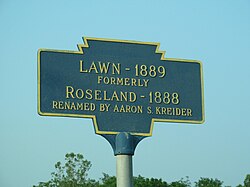
Lawn, previously known as Roseland, is an unincorporated community in South Londonderry Township in Lebanon County, Pennsylvania, United States. Lawn is located at the intersection of Pennsylvania Route 241 and Lawn Road. [2]

Related Research Articles

<span class="mw-page-title-main">Lebanon County, Pennsylvania</span> County in Pennsylvania, United States

LebanonCounty is a county in the Commonwealth of Pennsylvania. As of the 2020 census, the population was 143,257. Its county seat is the city of Lebanon.

<span class="mw-page-title-main">South Londonderry Township, Pennsylvania</span> Township in Pennsylvania, United States

South Londonderry Township is a township in Lebanon County, Pennsylvania, United States. It is part of the Lebanon, PA Metropolitan Statistical Area. The population was 8,763 at the 2020 census.

<span class="mw-page-title-main">Pennsylvania's 6th congressional district</span> U.S. House district for Pennsylvania

Pennsylvania's 6th congressional district is a district in the state of Pennsylvania. It includes all of Chester County and the southeastern portion of Berks County including the city of Reading and its southeastern suburbs. The district is represented by Democrat Chrissy Houlahan, who has served in Congress since 2019. As currently drawn, the district is among the wealthiest in Pennsylvania. The Supreme Court of Pennsylvania redrew the district in February 2018 after ruling the previous map unconstitutional.

<span class="mw-page-title-main">Aaron S. Kreider</span> American politician

Aaron Shenk Kreider was a Republican member of the U.S. House of Representatives from Pennsylvania.

<span class="mw-page-title-main">Cocalico Creek</span> River in Pennsylvania, United States

Cocalico Creek is a 27.2-mile-long (43.8 km) tributary of the Conestoga River in Lebanon and Lancaster counties in Pennsylvania in the United States. The source is at an elevation of 1,320 feet (400 m) near Stricklerstown in Millcreek Township, Lebanon County. The mouth is the confluence with the Conestoga River at an elevation of 278 feet (85 m) at Talmage in West Earl Township, Lancaster County.

Conewago Creek is a 23.0-mile-long (37.0 km) tributary of the Susquehanna River in Lebanon, Dauphin, and Lancaster counties in Pennsylvania in the United States. The source is at an elevation of 1,100 feet (340 m) at Mount Gretna Heights in Lebanon County. The mouth is the confluence with the Susquehanna River at an elevation of 261 feet (80 m) at the border of Dauphin and Lancaster counties, just south of Three Mile Island in the river and just north of the unincorporated village of Falmouth in Conoy Township, Lancaster County.

<span class="mw-page-title-main">Summit Lawn, Pennsylvania</span> Unincorporated village in Pennsylvania, U.S.

Summit Lawn is a small unincorporated village that is located in Lehigh County, Pennsylvania. It is part of the Lehigh Valley, which has a population of 861,899 and is the 68th-most populous metropolitan area in the U.S. as of the 2020 census.

<span class="mw-page-title-main">Pennsylvania's 15th congressional district</span> U.S. House district for Pennsylvania

Pennsylvania's 15th congressional district has been located in western and central Pennsylvania since 2019. Since 2023, the district includes all of Armstrong, Cameron, Centre, Clarion, Clearfield, Clinton, Elk, Forest, Jefferson, McKean, Potter, Snyder, Tioga, Union, and Warren counties and parts of Indiana, Lycoming, and Venango counties.

<span class="mw-page-title-main">Swatara State Park</span>

Swatara State Park is a 3,515-acre (1,422 ha) Pennsylvania state park in Bethel, Swatara and Union Townships, Lebanon and Pine Grove Township, Schuylkill Counties in Pennsylvania in the United States. 8 miles (13 km) of Swatara Creek lie within the park's boundaries, which are roughly formed by Pennsylvania Route 443 to the north and Interstate 81 to the south. The park is in a valley in the ridge and valley region of Pennsylvania between Second Mountain (north) and Blue Mountain (south).

<span class="mw-page-title-main">Pennsylvania's 17th congressional district</span> U.S. House district for Pennsylvania

Pennsylvania's 17th congressional district is located in southwestern Pennsylvania, which includes the entirety of Beaver County and the northwestern parts of Allegheny County not part of the 12th district. It has been represented since January 3, 2023 by Democrat Chris Deluzio.

<span class="mw-page-title-main">Harrisburg–Carlisle metropolitan statistical area</span> Metropolitan area in Pennsylvania, United States

The Harrisburg–Carlisle metropolitan statistical area, officially the Harrisburg–Carlisle, PA Metropolitan Statistical Area, and also referred to as the Susquehanna Valley, is defined by the Office of Management and Budget as an area consisting of three counties in South Central Pennsylvania, anchored by the cities of Harrisburg and Carlisle.

<span class="mw-page-title-main">Memorial Lake State Park</span>

Memorial Lake State Park is a Pennsylvania state park on 230 acres (93 ha) in East Hanover Township, Dauphin County, Pennsylvania in the United States. The park is surrounded by Fort Indiantown Gap Military Reservation, headquarters of the Pennsylvania National Guard. It includes Memorial Lake, which is 85 acres (34 ha), and is a 30-minute drive from Harrisburg just off Exit 85 of Interstate 81.

<span class="mw-page-title-main">Pennsylvania Route 341</span> State highway in Pennsylvania, US

Pennsylvania Route 341 is a state highway in the U.S. state of Pennsylvania. The route runs 10.7 miles (17.2 km) from PA 230 in Londonderry Township in Dauphin County east to PA 241 in South Londonderry Township in Lebanon County. The route is a two-lane undivided road known as Colebrook Road for its entire length, passing through rural areas. Along the way, PA 341 crosses PA 743 near Deodate and passes through Upper Lawn. An eastbound truck route, PA 341 Truck, bypasses the route between PA 230 and PA 743. PA 341 was first designated onto its current alignment by 1930, running between U.S. Route 230 and PA 241. The route was fully paved in the 1930s. Between the 1930s and 1940s, PA 341 headed southeast along Lawn Road to end at PA 241 in Lawn.

The 42nd Pennsylvania House of Representatives District is located in southwest Pennsylvania and has been represented since 2013 by Dan Miller.

<span class="mw-page-title-main">Pennsylvania House of Representatives, District 101</span> American legislative district

The 101st Pennsylvania House of Representatives District is located in Southeastern Pennsylvania and has been represented since 2023 by John A. Schlegel.

<span class="mw-page-title-main">National Register of Historic Places listings in Lebanon County, Pennsylvania</span>

This is a list of the National Register of Historic Places listings in Lebanon County, Pennsylvania.

Colebrook is an unincorporated community in South Londonderry Township in Lebanon County, Pennsylvania, United States. Colebrook is located at the intersection of Pennsylvania Route 117 and Mount Wilson Road just to the south of Pennsylvania Route 241.

Upper Lawn is an unincorporated community in South Londonderry Township in Lebanon County, Pennsylvania, United States. Upper Lawn is located at the intersection of Pennsylvania Route 341, Lawn Road, and Gingrich Road.

Harper Tavern is an unincorporated community in East Hanover Township in Lebanon County, Pennsylvania, United States. Harper Tavern is located at the intersection of Pennsylvania Route 934 and Jonestown Road along Swatara Creek.

The Pennsylvania State Game Lands Number 80 are Pennsylvania State Game Lands in Berks, Lebanon and Schuylkill Counties in Pennsylvania, providing hunting, bird watching, and other activities.

References

  1. "Lawn". Geographic Names Information System . United States Geological Survey, United States Department of the Interior.
  2. Lebanon County, Pennsylvania Highway Map (PDF) (Map). PennDOT. 2012. Retrieved September 3, 2013.[ permanent dead link ]