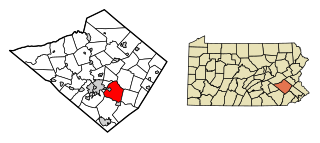
Birdsboro is a borough in Berks County, Pennsylvania, United States. It is located along the Schuylkill River 8 miles (13 km) southeast of Reading. As of the 2020 census, it had a population of 5,106. Birdsboro's economy had historically been rooted in large foundries and machine shops, none of which remain in operation today.
Exeter Township is a township in Berks County, Pennsylvania, United States. The population was 25,500 as of the 2020 census, making it the third-most populous municipality in Berks County after the city of Reading and Spring Township. Daniel Boone Homestead is within its borders. This formerly rural township is now made up of mostly sprawl-oriented developments along U.S. Route 422 and Route 562 Its school district also contains the adjacent borough of St. Lawrence.
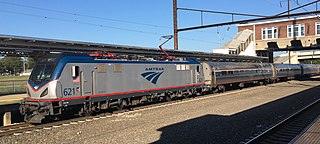
The Keystone Service is a 195 mile regional passenger train service from Amtrak between the Harrisburg Transportation Center in Harrisburg, Pennsylvania, and 30th Street Station in Philadelphia, running along the Philadelphia to Harrisburg Main Line. Most trains continue along the Northeast Corridor (NEC) to Penn Station in New York City.

The Pennsylvania Department of Transportation (PennDOT) oversees transportation issues in the Commonwealth of Pennsylvania. The administrator of PennDOT is the Pennsylvania Secretary of Transportation, Michael B. Carroll. PennDOT supports nearly 40,000 miles (64,000 km) of state roads and highways, about 25,000 bridges, and new roadway construction with the exception of the Pennsylvania Turnpike Commission.
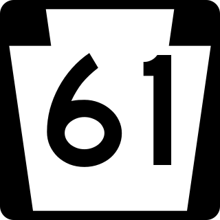
Pennsylvania Route 61 is an 81.8-mile-long (131.6 km) state highway that is located in Pennsylvania in the United States. The route is signed on a north–south direction, running from U.S. Route 222 Business in Reading northwest to US 11/US 15/PA 147 in Shamokin Dam.

The Columbia–Wrightsville Bridge, officially the Veterans Memorial Bridge, spans the Susquehanna River between Columbia and Wrightsville, Pennsylvania, and carries Pennsylvania Route 462 and BicyclePA Route S. Built originally as the Lancaster-York Intercounty Bridge, construction began in 1929, and the bridge opened September 30, 1930. On November 11, 1980, it was officially dedicated as Veterans Memorial Bridge, though it is still referenced locally as the Columbia–Wrightsville Bridge.

Pennsylvania Route 724 is a 30-mile (48 km) road in the U.S. commonwealth of Pennsylvania that runs from U.S. Route 422 in Sinking Spring southeast to PA 23 near Phoenixville. PA 724 travels through Berks and Chester counties. The route runs through the southern suburbs of Reading, passing through Shillington and Kenhorst. Past the Reading area, PA 724 continues southeast parallel to the Schuylkill River, passing through or near Birdsboro, Pottstown, and Spring City. The route intersects many roads including US 222 near Shillington, PA 10 and Interstate 176 (I-176) southeast of Reading, PA 345 in Birdsboro, and PA 100 and US 422 near Pottstown.
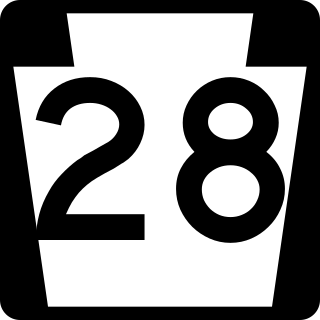
Pennsylvania Route 28 is a major state highway, which runs for 98 miles (158 km) from Anderson Street in Pittsburgh to U.S. Route 219 (US 219) in Brockway in Pennsylvania in the United States.

Interstate 95 (I-95) is a major north–south Interstate Highway that runs along the East Coast of the United States from Miami, Florida, north to the Canada–United States border at Houlton, Maine. In the state of Pennsylvania, it runs 51.00 miles (82.08 km) from the Delaware state line near Marcus Hook in Delaware County in the southeastern part of the state northeast to the Delaware River–Turnpike Toll Bridge at the New Jersey state line near Bristol in Bucks County, closely paralleling the New Jersey state line for its entire length through Pennsylvania.
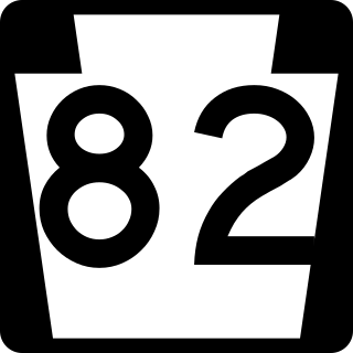
Pennsylvania Route 82 is a 32-mile-long (51 km) north–south state highway located in Chester County in southeast Pennsylvania, USA. The southern terminus is at the Delaware state line southeast of Kennett Square, where the road continues south into that state as Delaware Route 82. The northern terminus is at PA 23 in Elverson. PA 82 heads through rural areas of Chester County along with the communities of Kennett Square, Unionville, and Coatesville. The route intersects many important roads including U.S. Route 1 near Kennett Square, PA 162 and PA 842 in Unionville, US 30 in Coatesville, and US 322 in Brandywine Manor. PA 82 is a two-lane undivided road most of its length.

Pennsylvania Route 94 is a 30-mile (48 km) long north–south state highway located in southern Pennsylvania. The southern terminus of the route is at the Mason–Dixon line, where PA 94 continues into Maryland as Maryland Route 30. The northern terminus is at PA 34 south of Mount Holly Springs. PA 94 heads north-northwest from the state line through southwestern York County, where it passes through Hanover and intersects PA 116/PA 194 in the center of town. Past Hanover, the route heads into rural areas and crosses into the eastern portion of Adams County. Here, PA 94 intersects U.S. Route 30 east of New Oxford, PA 394 in Hampton, PA 234 north of Hampton, and US 15 in York Springs. The route heads into Cumberland County and crosses South Mountain, reaching its end at PA 34. PA 94 is designated as the 94th Infantry Division Memorial Highway for its entire length.

Pennsylvania Route 472 is a north–south state highway in Chester and Lancaster counties in Pennsylvania. Its southern terminus is at PA 841 in Lewisville 300 yards (270 m) north of the Maryland border. Its northern terminus is at PA 372 in Quarryville. PA 472 is a two-lane undivided road that passes through mostly rural areas along a northwest-southeast alignment. The route passes through the borough of Oxford, where it intersects the southern terminus of PA 10 and has an interchange with U.S. Route 1. PA 472 was originally designated in 1928 between US 1/PA 12/PA 42 in Oxford and PA 372 in Quarryville. The route was extended south to Hickory Hill by 1930, at which time the entire length of the route was paved. The southern terminus of PA 472 was extended to PA 841 in Lewisville in 1937.

Pennsylvania Route 345 is a 13-mile-long (21 km) state highway in the U.S. state of Pennsylvania. The route runs from PA 82 in West Nantmeal Township, Chester County, north to U.S. Route 422 near Birdsboro, Berks County. The route is a two-lane road its entire length, passing through the community of Warwick, Hopewell Furnace National Historic Site, French Creek State Park, and the borough of Birdsboro. PA 345 intersects PA 401 in East Nantmeal Township, PA 23 in Warwick, and PA 724 in Birdsboro. PA 345 was first designated by 1973 between PA 82 in West Nantmeal Township and PA 724 in Birdsboro. The route was extended north to US 422 in 2008, replacing a former section of PA 82 north of Birdsboro that was initially designated in 1928.

Pennsylvania Route 199 is a 4.8-mile-long (7.7 km) state highway located in Bradford County in Pennsylvania. The southern terminus is at U.S. Route 220 near Athens. The northern terminus is the New York state line in Sayre, where it connects to New York State Route 34 and an interchange with Interstate 86 (I-86)/NY 17. PA 199 runs north–south through the Penn-York Valley communities of Athens and Sayre, following Main Street in Athens and Keystone Avenue, Mohawk Street, and Spring Street in Sayre. The section of PA 199 between the southern terminus and the intersection of Keystone Avenue and Mohawk Street in Sayre was designated as part of US 711 when the U.S. Highway System was created in 1926, being renumbered to US 220 a year later. Between 1930 and the 1960s, US 309 was concurrent with this portion of US 220. In the 1970s, US 220 was moved to a western bypass of the towns and PA 199 was designated onto its current alignment.

Pennsylvania Route 210 is a 30-mile-long (48 km) state highway located in Armstrong and Indiana counties in Western Pennsylvania. The southern terminus is at PA 56/PA 156 in South Bend Township. The northern terminus is at U.S. Route 119 (US 119) near Covode.

Pennsylvania Route 281 is a 45.8-mile-long (73.7 km) state highway located in Fayette and Somerset counties in Pennsylvania. The southern terminus is the West Virginia state line near Markleysburg, where the road becomes West Virginia Route 26. The northern terminus is at U.S. Route 30 in Stoystown.

In the U.S. state of Pennsylvania, state highways are generally maintained by the Pennsylvania Department of Transportation (PennDOT). Each is assigned a four-digit State Route (SR) number in the present Location Referencing System. Traffic Routes are signed as Interstate Highways, U.S. Routes and Pennsylvania Routes, and are prefixed with one to three zeroes to give a four-digit number. PA Routes are also called Pennsylvania Traffic Routes, and formerly State Highway Routes.

Pennsylvania Route 981 is a state highway which runs 50.4 miles (81.1 km) across Westmoreland County, in southwestern Pennsylvania, United States. The highway begins at PA 51 in Rostraver Township, Pennsylvania, and runs northward across Westmoreland County, passing through the towns of Mount Pleasant, Latrobe, and New Alexandria before ending at PA 819 in Salina.

The Forksville Covered Bridge is a Burr arch truss covered bridge over Loyalsock Creek in the borough of Forksville, Sullivan County, in the U.S. state of Pennsylvania. It was built in 1850 and is 152 feet 11 inches (46.61 m) in length. The bridge was placed on the National Register of Historic Places in 1980. The Forksville bridge is named for the borough it is in, which in turn is named for its location at the confluence or "forks" of the Little Loyalsock and Loyalsock Creeks.