Benton, Columbia County, Pennsylvania

Last updated
Benton, Pennsylvania
Benton, Pennsylvania.JPG
View north on PA 487 in Benton in October 2012
Columbia County Pennsylvania Incorporated and Unincorporated areas Benton Highlighted.svg
Location of Benton in Columbia County, Pennsylvania (left) and of Columbia County in Pennsylvania (right)
Map of Pennsylvania highlighting Columbia County.svg
Map showing Columbia County in Pennsylvania
USA Pennsylvania location map.svg
Red pog.svg
Benton
Location of Benton in Pennsylvania
Usa edcp location map.svg
Red pog.svg
Benton
Benton (the United States)
Coordinates: 41°11′46″N76°23′00″W / 41.19611°N 76.38333°W / 41.19611; -76.38333
Country United States
State Pennsylvania
County Columbia
Settled1833
Incorporated1894
Government
  TypeBorough Council
  MayorGeorge Remphrey
Area
[1]
  Total0.61 sq mi (1.59 km2)
  Land0.60 sq mi (1.55 km2)
  Water0.02 sq mi (0.05 km2)
Elevation
765 ft (233 m)
Population
 (2020) [2]
  Total823
  Density1,378.56/sq mi (532.32/km2)
Time zone UTC-5 (Eastern (EST))
  Summer (DST) UTC-4 (EDT)
ZIP Code
17814
Area code 570
FIPS code 42-05680
GNIS feature ID1215122

Benton is a borough in Columbia County, Pennsylvania, United States. It is part of Northeastern Pennsylvania. The population was 824 at the 2020 census. [3] It is part of the Bloomsburg-Berwick micropolitan area.

Contents

Geography

Aerial view of Benton Benton, Pennsylvania.PNG
Aerial view of Benton

Benton is located in northern Columbia County at 41°11′46″N76°23′0″W / 41.19611°N 76.38333°W / 41.19611; -76.38333 (41.196144, -76.383354). [4] It is surrounded by Benton Township, a separate municipality. According to the United States Census Bureau, the borough has a total area of 0.61 square miles (1.59 km2), of which 0.60 square miles (1.55 km2) is land and 0.02 square miles (0.05 km2), or 2.96%, is water. [5] Fishing Creek, a south-flowing tributary of the Susquehanna River, runs through the eastern part of Benton.

History

The Benton area was first settled by two families in 1792. A schoolhouse was opened in 1799. Starting around 1860, tanning and lumber industries began to grow north of the borough. By 1868, Benton had about fifty houses. In the year of 1910, Benton was destroyed by a fire. Two teenagers lit firecrackers in a hay barn, which caught fire and caused over sixty buildings to burn, as the town did not yet have a water system. [6] As a result, the Benton Dam was built in 1915. However, this was not the end of Benton's disasters. Another fire struck just one year later destroying more houses. Again in 1962, a fire ripped through the town, destroying the distillery and its warehouse containing over 17,000 bottles of whiskey. In 2011, Benton was also devastated by a flood. And on April 15, 2019, an EF2 tornado touched down in Benton, damaging nine trailers and up to 50 homes and businesses. Despite its various adversities and disasters, Benton continues to thrive. [7] [8]

Transportation

State highways. Two highways concurrently serve as Benton's Main Street:

Main Street (Pennsylvania Routes 239/487) in Benton, looking north Main Street in Benton, Columbia County, Pennsylvania.JPG
Main Street (Pennsylvania Routes 239/487) in Benton, looking north

Interstate highway: Benton is 14 miles north of Interstate 80.

Air: Although Williamsport Regional Airport (IATA: IPT) is the closest airport with scheduled airline service, travelers often seek out the lower fares at Trenton–Mercer Airport (IATA: TTN) or Philadelphia International Airport (IATA: PHL).

Rail: From 1888 to 1972, Benton was served by the Bloomsburg and Sullivan Railroad, which was later the Reading Railroad's Bloomsburg branch.

Demographics

Historical population
CensusPop.Note
1880 191
1900 635
1910 71913.2%
1920 696−3.2%
1930 7335.3%
1940 7867.2%
1950 89013.2%
1960 98110.2%
1970 1,0274.7%
1980 981−4.5%
1990 958−2.3%
2000 955−0.3%
2010 824−13.7%
2020 8240.0%
2021 (est.)824 [3] 0.0%
Sources: [9] [10] [11] [12] [2]

As of the census [10] of 2000, there were 955 people, 394 households, and 265 families residing in the borough. The population density was 1,503.6 inhabitants per square mile (580.5/km2). There were 436 housing units at an average density of 686.5 per square mile (265.1/km2). The racial makeup of the borough was 99.69% White, 0.10% African American, and 0.21% from two or more races. Hispanic or Latino of any race were 0.10% of the population.

There were 394 households, out of which 33.2% had children under the age of 18 living with them, 48.5% were married couples living together, 12.9% had a female householder with no husband present, and 32.7% were non-families. 28.4% of all households were made up of individuals, and 10.4% had someone living alone who was 65 years of age or older. The average household size was 2.42 and the average family size was 2.95.

In the borough the population was spread out, with 25.9% under the age of 18, 10.3% from 18 to 24, 26.3% from 25 to 44, 22.3% from 45 to 64, and 15.3% who were 65 years of age or older. The median age was 36 years. For every 100 females, there were 91.4 males. For every 100 females age 18 and over, there were 84.9 males.

The median income for a household in the borough was $27,986, and the median income for a family was $32,125. Males had a median income of $28,015 versus $20,625 for females. The per capita income for the borough was $12,831. About 15.2% of families and 19.2% of the population were below the poverty line, including 29.0% of those under age 18 and 8.8% of those age 65 or over.

Education

Benton is part of the Benton Area School District, which contains two schools: L.R. Appleman Elementary School (K-6), and Benton Middle/Senior High School (7-12). There are 24 colleges within 50 miles of Benton Borough . The nearest college with over 2000 students is the Bloomsburg University of Pennsylvania [13] at a distance of 13.4 miles. The top rated college near Benton is Bucknell University.

Related Research Articles

<span class="mw-page-title-main">Columbia County, Pennsylvania</span> County in Pennsylvania, United States

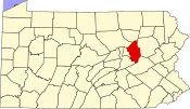
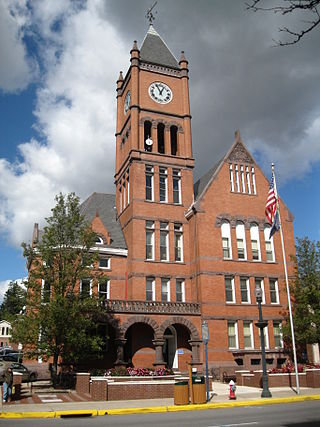
Columbia County is a county in the Commonwealth of Pennsylvania. It is located in Northeastern Pennsylvania. As of the 2020 census, the population was 64,727. Its county seat is Bloomsburg. The county was created on March 22, 1813, from part of Northumberland County. It was named Columbia, alluding to the United States and Christopher Columbus.

<span class="mw-page-title-main">Almedia, Pennsylvania</span> Census-designated place in Pennsylvania, United States

Almedia is a census-designated place (CDP) in Columbia County, Pennsylvania, United States. It is part of Northeastern Pennsylvania. The population was 1,078 at the 2010 census. It is part of the Bloomsburg-Berwick micropolitan area.

<span class="mw-page-title-main">Benton Township, Columbia County, Pennsylvania</span> Township in Pennsylvania, United States

Benton Township is a township in Columbia County, Pennsylvania. It is part of Northeastern Pennsylvania. The population was 1,323 at the 2020 census.

<span class="mw-page-title-main">Briar Creek, Pennsylvania</span> Borough in Pennsylvania, United States

Briar Creek is a borough in Columbia County, Pennsylvania, United States. It is part of Northeastern Pennsylvania. The population was 597 at the 2020 census. It is part of the Bloomsburg-Berwick micropolitan area.

<span class="mw-page-title-main">Buckhorn, Pennsylvania</span> Census-designated place in Pennsylvania, United States

Buckhorn is a census-designated place (CDP) in Columbia County, Pennsylvania, United States. It is part of Northeastern Pennsylvania. The population was 318 at the 2010 census. It is part of the Bloomsburg-Berwick micropolitan area. It uses the Bloomsburg ZIP code of 17815.

<span class="mw-page-title-main">Catawissa, Pennsylvania</span> Borough in Pennsylvania, United States

Catawissa is a borough in Columbia County, Pennsylvania, United States. It is part of Northeastern Pennsylvania. The population was 1,539 at the 2020 census. It is part of the Bloomsburg-Berwick micropolitan area.

<span class="mw-page-title-main">Catawissa Township, Pennsylvania</span> Township in Pennsylvania, United States

Catawissa Township is a township near the borough of Catawissa, Columbia County, Pennsylvania. It is part of Northeastern Pennsylvania. The population was 904 at the 2020 census.

<span class="mw-page-title-main">Espy, Pennsylvania</span> Census-designated place in Pennsylvania, United States

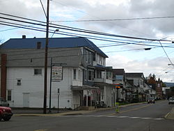
Espy is a census-designated place (CDP) in Columbia County, Pennsylvania, United States. It is part of Northeastern Pennsylvania. The population was 1,642 at the 2010 census. It is part of the Bloomsburg-Berwick micropolitan area. Espy was first settled in the late 18th century. It was home to a boatyard in the 19th century.

<span class="mw-page-title-main">Fernville, Pennsylvania</span> Census-designated place in Pennsylvania, United States

Fernville is a census-designated place (CDP) in Columbia County, Pennsylvania, United States. It is part of Northeastern Pennsylvania. The population was 556 at the 2010 census. It is part of the Bloomsburg-Berwick micropolitan area.

<span class="mw-page-title-main">Fishing Creek Township, Columbia County, Pennsylvania</span> Township in Pennsylvania, United States

Fishing Creek Township is a township in Columbia County, Pennsylvania. It is part of Northeastern Pennsylvania. The population was 1,416 at the 2010 census.

Foundryville is a census-designated place (CDP) in Columbia County, Pennsylvania, United States. It is part of Northeastern Pennsylvania. The population was 256 at the 2010 census. It is part of the Bloomsburg-Berwick micropolitan area.

<span class="mw-page-title-main">Jamison City, Pennsylvania</span> Census-designated place in Pennsylvania, United States

Jamison City is a census-designated place in Sugarloaf Township, Columbia County, Pennsylvania, United States. It is part of Northeastern Pennsylvania. The population was 134 at the 2010 census. It is part of the Bloomsburg-Berwick micropolitan area.

<span class="mw-page-title-main">Lime Ridge, Pennsylvania</span> Census-designated place in Pennsylvania, United States

Lime Ridge is a census-designated place (CDP) in Columbia County, Pennsylvania, United States. It is part of Northeastern Pennsylvania. The population was 890 at the 2010 census. It is part of the Bloomsburg-Berwick micropolitan area.

<span class="mw-page-title-main">Mifflinville, Pennsylvania</span> Census-designated place in Pennsylvania, United States

Mifflinville is an unincorporated community and census-designated place (CDP) in Columbia County, Pennsylvania, United States. It is part of Northeastern Pennsylvania. The population was 1,253 at the 2010 census. It is part of the Bloomsburg-Berwick micropolitan area.

<span class="mw-page-title-main">Millville, Pennsylvania</span> Borough in Pennsylvania, United States

Millville is a borough in Columbia County, Pennsylvania, United States. It is part of Northeastern Pennsylvania. As of the 2020 census it had a population of 976. It is part of the Bloomsburg-Berwick micropolitan area.

<span class="mw-page-title-main">Numidia, Pennsylvania</span> Census-designated place in Pennsylvania, United States

Numidia is a census-designated place (CDP) in Columbia County, Pennsylvania, United States. It is part of Northeastern Pennsylvania. The population was 244 at the 2010 census. It is part of the Bloomsburg-Berwick metropolitan area.

<span class="mw-page-title-main">Orangeville, Pennsylvania</span> Borough in Pennsylvania, United States

Orangeville is a borough in Columbia County, Pennsylvania, United States. It is part of Northeastern Pennsylvania. The population was 478 at the 2020 census. It is part of the Bloomsburg-Berwick micropolitan area.

<span class="mw-page-title-main">Slabtown, Pennsylvania</span> Census-designated place in Pennsylvania, United States

Slabtown is a census-designated place in Columbia County, Pennsylvania, United States. It is part of Northeastern Pennsylvania. The population was 156 at the 2010 census. It is part of the Bloomsburg-Berwick micropolitan area.

<span class="mw-page-title-main">South Centre Township, Pennsylvania</span> Township in Pennsylvania, United States

South Centre Township is a township in Columbia County, Pennsylvania. It is part of Northeastern Pennsylvania. The population was 1,908 at the 2020 census.

<span class="mw-page-title-main">Stillwater, Pennsylvania</span> Borough in Pennsylvania, United States

Stillwater is a borough in Columbia County, Pennsylvania, United States. It is part of Northeastern Pennsylvania. The population was 200 at the 2020 census. It is part of the Bloomsburg-Berwick micropolitan area.

References

  1. "ArcGIS REST Services Directory". United States Census Bureau. Retrieved October 12, 2022.
  2. 1 2 "Census Population API". United States Census Bureau. Retrieved Oct 12, 2022.
  3. 1 2 Bureau, US Census. "City and Town Population Totals: 2020—2021". Census.gov. US Census Bureau. Retrieved July 28, 2022.
  4. "US Gazetteer files: 2010, 2000, and 1990". United States Census Bureau. 2011-02-12. Retrieved 2011-04-23.
  5. "Geographic Identifiers: 2010 Census Summary File 1 (G001): Benton borough, Pennsylvania". U.S. Census Bureau, American Factfinder. Archived from the original on February 13, 2020. Retrieved May 19, 2015.
  6. "Valley Girl News".
  7. "Columbia Montour Visitors Bureau".
  8. "Bentonnews.net".
  9. "Census of Population and Housing". U.S. Census Bureau. Retrieved 11 December 2013.
  10. 1 2 "U.S. Census website". United States Census Bureau . Retrieved 2008-01-31.
  11. "Incorporated Places and Minor Civil Divisions Datasets: Subcounty Resident Population Estimates: April 1, 2010 to July 1, 2012". Population Estimates. U.S. Census Bureau. Archived from the original on 11 June 2013. Retrieved 11 December 2013.
  12. "Census of Population and Housing". Census.gov. Retrieved June 4, 2016.
  13. "Benton, Pennsylvania". 2012. Retrieved 20 October 2012.