Orangeville, Pennsylvania

Last updated
Orangeville, Pennsylvania
Orangeville, Pennsylvania.JPG
Looking south on PA 487 in Orangeville in October 2012
Columbia County Pennsylvania Incorporated and Unincorporated areas Orangeville Highlighted.svg
Location of Orangeville in Columbia County, Pennsylvania.
Map of Pennsylvania highlighting Columbia County.svg
Map showing Columbia County in Pennsylvania
USA Pennsylvania location map.svg
Red pog.svg
Orangeville
Location in Pennsylvania
Usa edcp location map.svg
Red pog.svg
Orangeville
Orangeville (the United States)
Coordinates: 41°04′43″N76°24′52″W / 41.07861°N 76.41444°W / 41.07861; -76.41444
Country United States
State Pennsylvania
County Columbia
Settled1822
Incorporated1900
Government
  TypeBorough Council
  MayorKevin Lehman
Area
[1]
  Total0.45 sq mi (1.17 km2)
  Land0.45 sq mi (1.15 km2)
  Water0.01 sq mi (0.02 km2)
Elevation
[2]
580 ft (180 m)
Population
 (2020) [3]
  Total479
  Density1,076.40/sq mi (415.48/km2)
Time zone UTC-5 (Eastern (EST))
  Summer (DST) UTC-4 (EDT)
ZIP Code
17859
Area code 570
FIPS code 42-56912

Orangeville is a borough in Columbia County, Pennsylvania, United States. It is part of Northeastern Pennsylvania. The population was 478 at the 2020 census. [4] It is part of the Bloomsburg-Berwick micropolitan area.

Contents

History

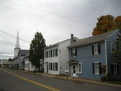
In 1822, an Ohio native Clemuel G. Ricketts made a plan to set up a community near Knob Mountain, although there were settlers in the area before that time. This community became Orangeville. Soon after the town was laid out, several buildings, including a house and a tannery, were erected in the area. Once five or six houses were built in the town, a post office was built there. Several names were originally considered for the community, including Knobtown, Rickettsville, and The Trap, but Orangeville was chosen after Orange County, New York, and Orange, New Jersey. In 1853, a business making plows and grain-threshers was built in the community. [5] Orangeville was incorporated in 1900. [6]

Geography

Orangeville is located north of the center of Columbia County at 41°04′43″N76°24′52″W / 41.078618°N 76.414573°W / 41.078618; -76.414573 . [7] It is entirely surrounded by Orange Township, a separate municipality. According to the U.S. Census Bureau, the borough has a total area of 0.46 square miles (1.2 km2), of which 0.008 square miles (0.02 km2), or 1.84%, is water. [8]

Orangeville is located 7 miles (11 km) north of Bloomsburg via Pennsylvania Route 487. Benton is 10 miles (16 km) to the north via PA 487. Pennsylvania Route 93 leads east from Orangeville 10 miles (16 km) to Berwick. Fishing Creek, a tributary of the Susquehanna River, runs on the northwestern edge of Orangeville. Knob Mountain's southwestern base is in the northeastern part of Orangeville. [9]

Demographics

Historical population
CensusPop.Note
1880 403
1900 439
1910 399−9.1%
1920 4174.5%
1930 415−0.5%
1940 4344.6%
1950 424−2.3%
1960 4444.7%
1970 431−2.9%
1980 50717.6%
1990 504−0.6%
2000 500−0.8%
2010 5081.6%
2020 478−5.9%
2021 (est.)478 [4] 0.0%
Sources: [10] [11] [12] [3]

As of the census [11] of 2000, there were 500 people, 146 households, and 95 families residing in the borough. The population density was 1,164.4 inhabitants per square mile (449.6/km2). There were 158 housing units at an average density of 368.0 per square mile (142.1/km2). The racial makeup of the borough was 98.00% White, 0.40% African American, 0.20% Native American, 0.20% Pacific Islander, 0.20% from other races, and 1.00% from two or more races. Hispanic or Latino of any race were 1.00% of the population.

There were 146 households, out of which 31.5% had children under the age of 18 living with them, 54.1% were married couples living together, 9.6% had a female householder with no husband present, and 34.9% were non-families. 29.5% of all households were made up of individuals, and 11.0% had someone living alone who was 65 years of age or older. The average household size was 2.49 and the average family size was 3.12.

In the borough the population was spread out, with 20.2% under the age of 18, 6.6% from 18 to 24, 21.4% from 25 to 44, 20.6% from 45 to 64, and 31.2% who were 65 years of age or older. The median age was 47 years. For every 100 females, there were 83.8 males. For every 100 females age 18 and over, there were 79.7 males.

The median income for a household in the borough was $35,000, and the median income for a family was $43,542. Males had a median income of $31,458 versus $20,875 for females. The per capita income for the borough was $17,167. About 1.0% of families and 6.0% of the population were below the poverty line, including 2.1% of those under age 18 and 19.0% of those age 65 or over.

Education

The area's local school district is the Central Columbia School District. It serves about 2,100 students and features three academic buildings and one administration building. Students are divided into the Elementary School (grades K through 4), Middle School (grades 5 through 8) and the High School (grades 9 through 12).

According to the 2003 data collected by Standard & Poor's, 18.4% of students are economically disadvantaged, 13.1% receive special education services and 71.1% of students pass the state-mandated testing. The district spends about $6,999 per student. [13]

In 2007, the Pittsburgh Business Times ranked the district 146th out of 499 Pennsylvania school districts based on three years of Pennsylvania System of Student Assessment test scores. [14]

Map of Columbia County, Pennsylvania School Districts, with Central Columbia School District in blue in the center of the county. Map of Columbia County Pennsylvania School Districts.png
Map of Columbia County, Pennsylvania School Districts, with Central Columbia School District in blue in the center of the county.

The Middle School underwent a major renovation from 2006-2007. Part of this renovation included several small additions that help the school accommodate for increasing class size.

Related Research Articles

<span class="mw-page-title-main">Marietta, Pennsylvania</span> Borough in Pennsylvania, United States

Marietta is a borough in Lancaster County, Pennsylvania, United States. The population was 2,633 at the 2020 census. It is located on the east bank of the Susquehanna River, northwest of Columbia.

<span class="mw-page-title-main">Columbia County, Pennsylvania</span> County in Pennsylvania, United States

Columbia County is a county in the Commonwealth of Pennsylvania. It is located in Northeastern Pennsylvania. As of the 2020 census, the population was 64,727. Its county seat is Bloomsburg. The county was created on March 22, 1813, from part of Northumberland County. It was named Columbia, alluding to the United States and Christopher Columbus.

<span class="mw-page-title-main">Benton, Columbia County, Pennsylvania</span> Borough in Pennsylvania, United States

Benton is a borough in Columbia County, Pennsylvania, United States. It is part of Northeastern Pennsylvania. The population was 824 at the 2020 census. It is part of the Bloomsburg-Berwick micropolitan area.

<span class="mw-page-title-main">Berwick, Pennsylvania</span> Borough in Pennsylvania, United States

Berwick is a borough in Columbia County, Pennsylvania, United States. It is part of Northeastern Pennsylvania and is located 28 miles (45 km) southwest of Wilkes-Barre. As of the 2020 census, Berwick had a population of 10,355. It is one of the two principal communities of the Bloomsburg–Berwick metropolitan area, which covers Columbia and Montour counties, and had a combined population of 85,562 at the 2010 census.

<span class="mw-page-title-main">Bloomsburg, Pennsylvania</span> Town in Pennsylvania, United States

Bloomsburg is a town and the county seat of Columbia County, Pennsylvania, United States. It is part of Northeastern Pennsylvania and is located 40 miles (64 km) southwest of Wilkes-Barre along the Susquehanna River. It is the only Pennsylvania municipality incorporated as a town. As of the 2010 census, Bloomsburg had a population of 14,855, with an estimated population of 13,811 in 2019.

<span class="mw-page-title-main">Catawissa, Pennsylvania</span> Borough in Pennsylvania, United States

Catawissa is a borough in Columbia County, Pennsylvania, United States. It is part of Northeastern Pennsylvania. The population was 1,539 at the 2020 census. It is part of the Bloomsburg-Berwick micropolitan area.

<span class="mw-page-title-main">Espy, Pennsylvania</span> Census-designated place in Pennsylvania, United States

Espy is a census-designated place (CDP) in Columbia County, Pennsylvania, United States. It is part of Northeastern Pennsylvania. The population was 1,642 at the 2010 census. It is part of the Bloomsburg-Berwick micropolitan area. Espy was first settled in the late 18th century. It was home to a boatyard in the 19th century.

<span class="mw-page-title-main">Jerseytown, Pennsylvania</span> Census-designated place in Pennsylvania, United States

Jerseytown is a census-designated place (CDP) that is located in Madison Township, Columbia County, Pennsylvania, United States. It is part of Northeastern Pennsylvania and of the Bloomsburg-Berwick micropolitan area.

<span class="mw-page-title-main">Lightstreet, Pennsylvania</span> Census-designated place in Pennsylvania, United States

Lightstreet is a census-designated place (CDP) in Columbia County, Pennsylvania, United States. It is part of Northeastern Pennsylvania. The population was 1,093 at the 2010 census. It is part of the Bloomsburg-Berwick micropolitan area. The CDP is named after a street in Baltimore.

Locustdale is a census-designated place (CDP) that is located on the border of Columbia and Schuylkill counties, Pennsylvania, United States. It is part of Northeastern Pennsylvania.

<span class="mw-page-title-main">Mifflinville, Pennsylvania</span> Census-designated place in Pennsylvania, United States

Mifflinville is an unincorporated community and census-designated place (CDP) in Columbia County, Pennsylvania, United States. It is part of Northeastern Pennsylvania. The population was 1,253 at the 2010 census. It is part of the Bloomsburg-Berwick micropolitan area.

<span class="mw-page-title-main">Millville, Pennsylvania</span> Borough in Pennsylvania, United States

Millville is a borough in Columbia County, Pennsylvania, United States. It is part of Northeastern Pennsylvania. As of the 2020 census it had a population of 976. It is part of the Bloomsburg-Berwick micropolitan area.

<span class="mw-page-title-main">Mount Pleasant Township, Columbia County, Pennsylvania</span> Township in Pennsylvania, United States

Mount Pleasant Township is a township in Columbia County, Pennsylvania. It is part of Northeastern Pennsylvania. As of the 2020 census, the township population was 1,506.

<span class="mw-page-title-main">Numidia, Pennsylvania</span> Census-designated place in Pennsylvania, United States

Numidia is a census-designated place (CDP) in Columbia County, Pennsylvania, United States. It is part of Northeastern Pennsylvania. The population was 244 at the 2010 census. It is part of the Bloomsburg-Berwick metropolitan area.

<span class="mw-page-title-main">Orange Township, Columbia County, Pennsylvania</span> Township in Pennsylvania, United States

Orange Township is a township in Columbia County, Pennsylvania. It is part of Northeastern Pennsylvania. The population was 1,163 at the 2020 census.

<span class="mw-page-title-main">Rohrsburg, Pennsylvania</span> Census-designated place in Pennsylvania, United States

Rohrsburg is a census-designated place (CDP) in Columbia County, Pennsylvania, United States. It is part of Northeastern Pennsylvania. The population was 145 at the 2010 census. It is part of the Bloomsburg-Berwick micropolitan area.

<span class="mw-page-title-main">Rupert, Pennsylvania</span> Census-designated place in Pennsylvania, United States

Rupert is a census-designated place (CDP) in Columbia County, Pennsylvania, United States. It is part of Northeastern Pennsylvania. The population was 183 at the 2010 census. It is part of the Bloomsburg-Berwick micropolitan area.

<span class="mw-page-title-main">South Centre Township, Columbia County, Pennsylvania</span> Township in Pennsylvania, United States

South Centre Township is a township in Columbia County, Pennsylvania. It is part of Northeastern Pennsylvania. The population was 1,908 at the 2020 census.

<span class="mw-page-title-main">Jordan Township, Lycoming County, Pennsylvania</span> Township in Pennsylvania, United States

Jordan Township is a township in Lycoming County, Pennsylvania, United States. The population was 850 at the 2020 census. It is part of the Williamsport Metropolitan Statistical Area.

<span class="mw-page-title-main">Eagles Mere, Pennsylvania</span> Borough in Pennsylvania, United States

Eagles Mere is a borough in Sullivan County, Pennsylvania, United States. The population was 151 at the 2020 census.

References

  1. "ArcGIS REST Services Directory". United States Census Bureau. Retrieved October 12, 2022.
  2. "Orangeville, Pennsylvania (PA 17859) profile: Population, maps, real estate, averages, homes, statistics, relocation, travel, jobs, hospitals, schools, crime, moving, houses, news, sex offenders".
  3. 1 2 "Census Population API". United States Census Bureau. Retrieved Oct 12, 2022.
  4. 1 2 Bureau, US Census. "City and Town Population Totals: 2020—2021". Census.gov. US Census Bureau. Retrieved July 31, 2022.
  5. "Chapter XIII, Mount Pleasant and Orange Townships, History of Columbia and Montour Counties, Pennsylvania".
  6. "Orangeville Borough, Columbia County, Pennsylvania (PA) 17859".
  7. "US Gazetteer files: 2010, 2000, and 1990". United States Census Bureau. 2011-02-12. Retrieved 2011-04-23.
  8. "Geographic Identifiers: 2010 Census Summary File 1 (G001): Orangeville borough, Pennsylvania". U.S. Census Bureau, American Factfinder. Archived from the original on February 13, 2020. Retrieved May 20, 2015.
  9. maps.google.com
  10. "Census of Population and Housing". U.S. Census Bureau. Retrieved 11 December 2013.
  11. 1 2 "U.S. Census website". United States Census Bureau . Retrieved 2008-01-31.
  12. "Incorporated Places and Minor Civil Divisions Datasets: Subcounty Resident Population Estimates: April 1, 2010 to July 1, 2012". Population Estimates. U.S. Census Bureau. Archived from the original on June 11, 2013. Retrieved 11 December 2013.
  13. Central Columbia School District report Archived 2007-09-27 at the Wayback Machine , School Matters, Standard & Poors 2003, 2005.
  14. Blacklidge, Karen, Valley schools all over the Chart, The Daily Item, June 6, 2007. "Valley schools all over the chart » News » the Daily Item, Sunbury, PA". Archived from the original on 2012-07-30. Retrieved 2007-10-15.