French Creek | |
---|---|
Location | |
Country | United States |
State | New York, Pennsylvania |
County | Chautauqua County, New York, and Erie, Crawford, Mercer, and Venango counties in Pennsylvania |
Physical characteristics | |
Source | North Harmony State Forest |
• location | near French Creek, New York, Chautauqua County, New York |
• coordinates | 42°06′14″N79°31′52″W / 42.10389°N 79.53111°W [1] |
• elevation | 1,737 ft (529 m) [2] |
Mouth | Allegheny River |
• location | Franklin, Pennsylvania |
• coordinates | 41°23′30″N79°49′13″W / 41.39167°N 79.82028°W [1] |
• elevation | 961 ft (293 m) [1] |
Length | 117 mi (188 km) |
Basin size | 1,270 sq mi (3,300 km2) |
Discharge | |
• location | Utica |
• average | 2,019 cu ft/s (57.2 m3/s) [3] |
Basin features | |
Tributaries | |
• left | Alder Bottom Creek Beaver Meadow Brook Herrick Creek Hubbel Run Alder Run South Branch French Creek Muddy Creek Mohawk Run Gravel Run Woodcock Creek Shellhammer Hollow Bennyhoof Creek Mill Run Little Sugar Creek Powdermill Run McCune Run Sugar Creek Patchel Run |
• right | Black Brook West Branch French Creek Lake Pleasant Outlet Wheeler Creek LeBoeuf Creek Campbell Run Conneauttee Creek Foulk Run North Deer Creek Mill Creek |
French Creek (also known as the Venango River) is a tributary of the Allegheny River in northwestern Pennsylvania and western New York in the United States.
The stream has been sometimes called a river and sometimes a creek. [1] It is thought that the stream's Seneca name, in nungash, was modified over time to Venango. The phrase in nungash may have derived from Onenga, the Seneca word for mink, or it may have stemmed from Winingus, the Delaware (Lenape) word for the same animal. Interpretations of Venango have included "crooked", and the Seneca chief Cornplanter suggested that in nungash referred to a particular carving on a tree along the stream. [4] Venango was likewise the name of a native settlement at the creek's mouth, later the site of Franklin, Pennsylvania. [5]
In the 18th century, the stream was an important link between the Great Lakes and the Ohio River. The French built Fort Presque Isle and Fort Le Boeuf to control the portage from the stream's headwaters to Lake Erie. [6] They called the stream Rivière aux boeufs (Cattle River) because the bison in the vicinity reminded them of French cattle. [4] In 1753, George Washington, still a British subject, was sent to deliver a message to Fort Le Boeuf asking the French to leave the region, [6] as tensions increased before the French and Indian War. Washington called the stream French Creek rather than Beef Creek (another common rendering of Rivière aux Boeufs), and his version prevailed [4] after the British won the Seven Years' War and took control of former French colonies in North America east of the Mississippi River.
French Creek begins near French Creek, New York, and flows about 117 miles (188 km) to the Allegheny River at Franklin, Pennsylvania. The creek's drainage basin covers 1,270 square miles (3,300 km2). [7] The watershed includes parts of Erie, Crawford, Venango, and Mercer counties in Pennsylvania as well as Chautauqua County in New York. [1] Cities and towns along its main stem include Mill Village, Wattsburg, Cambridge Springs, Venango, Saegertown, Meadville, Cochranton, Utica, Sugarcreek, and Franklin, all in Pennsylvania. [8]
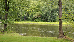
Providing habitat to more than 80 species of fish and 26 species of freshwater mussels, French Creek is among the most biologically diverse streams in the northeastern United States. [9]
Environmental concerns about the creek's water quality have been raised since at least the 1990s. Improvements to sewage treatment plants in Meadville, Cambridge Springs, and Saegertown have helped reduce the amount of chlorine and other chemicals entering the stream. Farm and highway runoff, malfunctioning septic systems, erosion, sedimentation, invasive species, and damaged riparian zones are other problems affecting the creek. [10] The French Creek Project, organized in 1995, sponsors French Creek music festivals, ecology tours, and watershed classes for the public. [9]
The creek won the Pennsylvania Department of Conservation and Natural Resources award for River of the Year in 2003. [9]
The creek was again named River of the Year for 2022. The citation reads:
"French Creek is one of the most biologically diverse waterways of its size in the United States, meandering 117 miles from its headwaters in southern New York through four Pennsylvania counties to the Allegheny River,” according to the release. “The creek is home to 27 species of freshwater mussels, more than 80 species of fish, and numerous waterfowl and songbird species, including bald eagles and four Audubon-designated Important Bird Areas (IBAs). French Creek is also home to the Eastern Hellbender, the largest species of salamander in North America, which was recently named the official amphibian of Pennsylvania.” [11]
The Allegheny River is a 325-mile-long (523 km) headwater stream of the Ohio River that is located in western Pennsylvania and New York in the United States. It runs from its headwaters just below the middle of Pennsylvania's northern border, northwesterly into New York, then in a zigzag southwesterly across the border and through Western Pennsylvania to join the Monongahela River at the Forks of the Ohio at Point State Park in Downtown Pittsburgh, Pennsylvania.
Venango County is a county in the Commonwealth of Pennsylvania. As of the 2020 census, the population was 50,454. Its county seat is Franklin. The county was created in 1800 and later organized in 1805. The county is part of the Northwest Pennsylvania region of the state.
Franklin is a city in and the county seat of Venango County, Pennsylvania, United States, located at the confluence of French Creek and the Allegheny River. The population was 6,097 in the 2020 census. Franklin is part of the Oil City micropolitan area.
Fort Le Bœuf was a fort established by the French during 1753 on a fork of French Creek, in present-day Waterford, in northwest Pennsylvania. The fort was part of a line that included Fort Presque Isle, Fort Machault, and Fort Duquesne.
Fort Venango was a small British fort built in 1760 near the present-day site of Franklin, Pennsylvania. It replaced Fort Machault, a French fort built at the confluence of French Creek and the Allegheny River. In August 1759, near the end of the French and Indian War, after the French surrender of Fort Niagara to the British, the French burned Fort Machault and retreated north. Fort Venango was built during summer 1760. It was attacked and destroyed in June 1763 during Pontiac's War.
Fort Machault was a fort built by the French in 1754 near the confluence of French Creek with the Allegheny River, in northwest Pennsylvania. The fort helped the French control these waterways, part of what was known as the Venango Path from Lake Erie to the Ohio River. It was one of four forts designed to protect French access to the Ohio Country and connections between its northern and southern colonies. From north to south the forts were Fort Presque Isle, Fort Le Boeuf, Fort Machault, and Fort Duquesne. In January 1759 the British launched an expedition to attack Fort Machault, but had to turn back after encountering resistance from French-Allied Native Americans. The fort was abandoned by the French in August 1759, and burned so that the British could not use it. It was replaced by the British in 1760 with Fort Venango.
Anderson Creek is a 23.6-mile-long (38.0 km) tributary of the West Branch Susquehanna River in Clearfield County, Pennsylvania, in the United States.
The Casselman River is a 56.5-mile-long (90.9 km) tributary of the Youghiogheny River in western Maryland and Pennsylvania in the United States. The Casselman River drains an area of 576 square miles.
Conewango Creek is a 71-mile-long (114 km) tributary of the Allegheny River in Pennsylvania and western New York in the United States.
Oil Creek is a 46.7-mile (75.2 km) tributary of the Allegheny River that is located in Venango and Crawford counties in the Commonwealth of Pennsylvania in the United States.
Venango Path was a Native American trail between the Forks of the Ohio and Presque Isle, Pennsylvania, United States of America. The latter was located at Lake Erie. The trail, a portage between these important water routes, was named after the Lenape village of Venango, at the confluence of French Creek and the Allegheny River. The village site was later developed by European Americans as the small city of Franklin, Pennsylvania.
Cussewago Creek is a 35.08 mi (56.46 km) long tributary to French Creek that is classed as a 4th order stream on the EPA waters geoviewer site.
The Beaver and Erie Canal, also known as the Erie Extension Canal, was part of the Pennsylvania Canal system and consisted of three sections: the Beaver Division, the Shenango Division, and the Conneaut Division. The canal ran 136 miles (219 km) north–south near the western edge of the state from the Ohio River to Lake Erie through Beaver County, Lawrence County, Mercer County, Crawford County, and Erie County, Pennsylvania.
Girty's Run is a tributary of the Allegheny River located in Allegheny County in the U.S. state of Pennsylvania.
The Goschgoschink Path, later known as Mead's Path, begins at the junction of the Great Shamokin Path at The Big Spring near Luthersburg, Brady Township, Clearfield County, Pennsylvania. The path then proceeds to Thunderbird Spring, Sandy Valley Station, north of Reynoldsville, Jefferson County, thence through the Horme Settlement and slightly north of Emerickville to Brookville; north of Clarion, to West Hickory, Pennsylvania, in Forest County and the Allegheny River. From here, travelers could journey to Fort Le Boeuf and Lake Erie.
The Big Spring near Luthersburg, Brady Township, Clearfield County, Pennsylvania, was an important camp site and trail hub for the Great Shamokin Path and the Goschgoschink Path.
Sugar Creek is a 22.66 mi (36.47 km) long 4th order tributary to French Creek in Venango County, Pennsylvania that rises in Crawford County, Pennsylvania.
Mill Creek is a 11.36 mi (18.28 km) long 2nd order tributary to French Creek in Mercer and Venango County, Pennsylvania.
McCune Run is a 4.57 mi (7.35 km) long 3rd order tributary to French Creek in Venango County, Pennsylvania.
Powdermill Run is a 4.32 mi (6.95 km) long 2nd order tributary to French Creek in Venango County, Pennsylvania, Crawford and Mercer Counties, Pennsylvania.