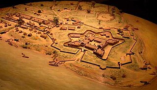
Fort Duquesne was a fort established by the French in 1754, at the confluence of the Allegheny and Monongahela rivers. It was later taken over by the British, and later the Americans, and developed as Pittsburgh in the U.S. state of Pennsylvania. Fort Duquesne was destroyed by the French before its British conquest during the Seven Years' War, known as the French and Indian War on the North American front. The British replaced it, building Fort Pitt between 1759 and 1761. The site of both forts is now occupied by Point State Park, where the outlines of the two forts have been laid in brick.
Connoquenessing Township is a township in Butler County, Pennsylvania, United States. The population was 4,265 at the 2020 census.
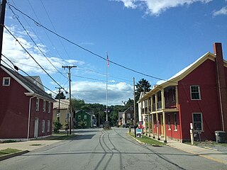
Harmony is a borough in Butler County, Pennsylvania, United States. The population was 890 at the 2010 census. It is located approximately 30 miles (48 km) north of Pittsburgh.

Franklin is a city in and the county seat of Venango County, Pennsylvania, United States, located at the confluence of French Creek and the Allegheny River. The population was 6,097 in the 2020 census. Franklin is part of the Oil City micropolitan area.

Christopher Gist (1706–1759) was an explorer, surveyor, and frontiersman active in Colonial America. He was one of the first white explorers of the Ohio Country. Gist is credited with providing the first detailed description of the Ohio Country to colonists in the Thirteen Colonies. At the outbreak of the French and Indian War, Gist accompanied Colonel George Washington on missions into this wilderness and saved Washington's life on two occasions.

French Creek is a tributary of the Allegheny River in northwestern Pennsylvania and western New York in the United States.

Fort Le Bœuf was a fort established by the French during 1753 on a fork of French Creek, in present-day Waterford, in northwest Pennsylvania. The fort was part of a line that included Fort Presque Isle, Fort Machault, and Fort Duquesne.
Fort Venango, a small British fort built in 1760 near the present-day site of Franklin, Pennsylvania, replaced Fort Machault, a French fort built at the confluence of French Creek and the Allegheny River. The French burned their fort in 1759 after abandoning it. They retreated to the north after learning of the French surrender to the British of Fort Niagara, near the end of the French and Indian War.

Fort Presque Isle was a fort built by French soldiers in summer 1753 along Presque Isle Bay in present-day Erie, Pennsylvania, to protect the northern terminus of the Venango Path. It was the first of the French posts built in the Ohio Country, and was part of a line that included Fort Le Boeuf, Fort Machault, and Fort Duquesne.
The riverside village of Logstown also known as Logg's Town, French: Chiningue near modern-day Baden, Pennsylvania, was a significant Native American settlement in Western Pennsylvania and the site of the 1752 signing of the Treaty of Logstown between the Ohio Company, the Colony of Virginia, and the Six Nations, which occupied the region. Being an unusually large settlement, and because of its strategic location in the Ohio Country, an area contested by France and England, Logstown was an important community for all parties living along the Ohio and tributary rivers. Logstown was a prominent trade and council site for the contending British and French colonial governments, both of which made abortive plans to construct forts near the town. Logstown was burned in 1754 and although it was rebuilt, in the years following the French and Indian War it became depopulated and was eventually abandoned.
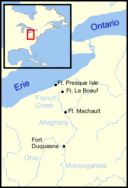
Fort Machault was a fort built by the French in 1754 near the confluence of French Creek with the Allegheny River, in northwest Pennsylvania. The fort helped the French control these waterways, part of what was known as the Venango Path from Lake Erie to the Ohio River.

Anderson Creek is a 23.6-mile-long (38.0 km) tributary of the West Branch Susquehanna River in Clearfield County, Pennsylvania, in the United States.
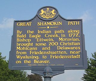
The Great Shamokin Path was a major Native American trail in the U.S. State of Pennsylvania that ran from the native village of Shamokin along the left bank of the West Branch Susquehanna River north and then west to the Great Island. There it left the river and continued further west to Chinklacamoose and finally Kittanning on the Allegheny River.
Murdering Town was a Lenni Lenape community that comprised several smaller villages along the Connoquenessing Creek and Breakneck Creek near present-day Harmony, and Evans City, Pennsylvania, United States. The village was located along the Venango Path which ran through what was then the Ohio Country during the French and Indian War. Today, the area is part of Western Pennsylvania.

The French Creek Council serves Boy Scouts in six counties in northwestern Pennsylvania and one township in Ohio. The council was organized in 1972 from a merger of the former Washington Trail Council of Erie, Custaloga Council of Sharon and Colonel Drake Council of Oil City, Pennsylvania. It has headquarters in Erie, Pennsylvania.
Eidenau is an unincorporated community in Jackson Township, Butler County, Pennsylvania, United States.
John Fraser was a fur trader licensed by the Province of Pennsylvania for its western frontier, an interpreter with Native Americans, a gunsmith, a guide and lieutenant in the British army, and a land speculator. He served in several of England's expeditions against the French and their allies in the vicinity of Fort Duquesne and later Fort Pitt.

Old Portage Road, also known as Old French Road and as French Portage Trail, was a Native American trail and later a road in present-day Chautauqua County, New York, that connected Lake Erie and Chautauqua Lake, and thereby the Great Lakes and the Mississippi River systems. Lake Erie is approximately 700 feet above sea level; the continental crest on this portage route between the St. Lawrence and Mississippi drainage basins is approximately 1500 feet above sea level.
Philippe-Thomas Chabert de Joncaire, also known as Nitachinon by the Iroquois, was a French army officer and interpreter in New France who established Fort Machault in the 18th century. During his career, he largely served as a diplomat with the indigenous nations rather than as a soldier.

Shannopin's Town, or Shannopintown, was an 18th-century Lenape (Delaware) town located within the site of modern-day Pittsburgh, Pennsylvania, along the Allegheny River, approximately two miles east from its junction with the Monongahela River. In the early 1700s, British colonial settlers began spreading into western Pennsylvania, forcing Lenape and other American Indian tribes to move further west, settling in the Ohio Country. Shannopin's Town was one of several communities established in western Pennsylvania in the 1720s. The town was largely abandoned during the construction of Fort Duquesne in 1754, although a small community still existed when General John Forbes' troops arrived in September 1758. The community was gone by the time construction on Fort Pitt was started in 1759.
