Pennsburg, Pennsylvania

Last updated
Borough of Pennsburg
Farmers National Bank Building, Pennsburg, MontCo PA.JPG
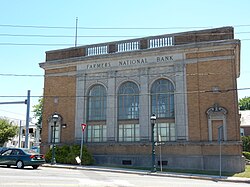
Farmers National Bank Building, built in 1926 in Pennsburg, May 2015
Pennsburg Montgomery County.png
Location of Pennsburg in Montgomery County, Pennsylvania
USA Pennsylvania location map.svg
Red pog.svg
Pennsburg
Location of Pennsburg in Pennsylvania
Usa edcp location map.svg
Red pog.svg
Pennsburg
Pennsburg (the United States)
Coordinates: 40°23′44″N75°29′50″W / 40.39556°N 75.49722°W / 40.39556; -75.49722
CountryUnited States
StatePennsylvania
County Montgomery
IncorporatedApril 9, 1888
Government
  TypeCouncil-manager
  MayorVicki J. Lightcap
Area
[1]
  Total0.80 sq mi (2.07 km2)
  Land0.80 sq mi (2.07 km2)
  Water0.00 sq mi (0.00 km2)
Elevation
381 ft (116 m)
Population
 (2020) [2]
  Total3,889
  Density4,861.25/sq mi (1,876.24/km2)
Time zone UTC-5 (EST)
  Summer (DST) UTC-4 (EDT)
ZIP Code
18073
Area codes 215, 267, and 445
FIPS code 42-59120
School district Upper Perkiomen School District
Website http://www.pennsburg.us

Pennsburg is a borough in Montgomery County, Pennsylvania. Its population was 3,889 at the 2020 census. It is part of the Upper Perkiomen School District. It is also part of the strip of small towns that run together along Route 29: Red Hill, Pennsburg, and East Greenville. The towns are collectively referred to as Upper Perk.

Contents

Geography

Pennsburg is located at 40°23′44″N75°29′50″W / 40.39556°N 75.49722°W / 40.39556; -75.49722 (40.395595, −75.497361). [3] According to the U.S. Census Bureau, the borough has a total area of 0.8 square miles (2.1 km2), all land. Pennsburg is located 40 mi (64 km) northwest of Philadelphia and 5 mi (8.0 km) southwest of Quakertown. Pennsburg's elevation is at 350 ft (110 m) above sea level. A nature preserve is along Macoby Creek. [4]

The borough has a hot-summer, humid continental climate (Dfa) and average monthly temperatures range from 29.9°F in January to 74.6°F in July. [5] The USDA hardiness zone is 7a.

Demographics

Historical population
CensusPop.Note
1890 627
1900 1,03264.6%
1910 1,14110.6%
1920 1,40423.0%
1930 1,4946.4%
1940 1,5433.3%
1950 1,6255.3%
1960 1,6984.5%
1970 2,26033.1%
1980 2,3393.5%
1990 2,4605.2%
2000 2,73211.1%
2010 3,84340.7%
2020 3,8891.2%
[6] [2]

As of the 2010 census, the borough was 90.0% White, 2.0% Black or African American, 0.1% Native American, 5.2% Asian, 0.1% Native Hawaiian, and 1.4% of two or more races. About 4.1% of the population were of Hispanic or Latino ancestry. [7]

As of the 2000 census, [8] 2,732 people, 1,009 households, and 705 families resided in the borough. The population density was 3,567.8 inhabitants per square mile (1,377.5/km2). The 1,078 housing units averaged 1,407.8 per square mile (540.5/km2). The racial makeup of the borough was 97.36% White, 0.81% African American, 0.07% Native American, 0.48% Asian, 0.55% from other races, and 0.73% from two or more races. Hispanics or Latinos of any race were 1.61% of the population.

Of the 1,009 households, 38.1% had children under the age of 18 living with them, 55.2% were married couples living together, 9.8% had a female householder with no husband present, and 30.1% were not families. About 24.0% of all households were made up of individuals, and 8.5% had someone living alone who was 65 years of age or older. The average household size was 2.59 and the average family size was 3.08.

In the borough, the population was age distributed as 27.0% under the age of 18, 7.4% from 18 to 24, 33.1% from 25 to 44, 18.4% from 45 to 64, and 14.1% who were 65 years of age or older. The median age was 35 years. For every 100 females, there were 90.4 males. For every 100 females age 18 and over, there were 90.9 males.

The median income for a household in the borough was $46,715, and for a family was $56,250. Males had a median income of $37,036 versus $26,190 for females. The per capita income for the borough was $18,977. About 4.4% of families and 6.2% of the population were below the poverty line, including 6.3% of those under age 18 and 3.7% of those age 65 or over.

Transportation

PA Route 29 South in Pennsburg 2022-10-26 14 43 34 View south along Pennsylvania State Route 29 (Main Street) just south of Pennsylvania State Route 663 (Pottstown Avenue-Quakertown Avenue) in Pennsburg, Montgomery County, Pennsylvania.jpg
PA Route 29 South in Pennsburg
An East Penn Railroad locomotive in Pennsburg in April 2014 East Penn Rail Road Locomotive, Pennsburg Montco PA.jpg
An East Penn Railroad locomotive in Pennsburg in April 2014

As of 2014 there were 10.05 miles (16.17 km) of public roads in Pennsburg, of which 2.56 miles (4.12 km) were maintained by the Pennsylvania Department of Transportation (PennDOT) and 7.77 miles (12.50 km) were maintained by the borough. [9]

Pennsburg lies at the junction of Pennsylvania Route 29 and Pennsylvania Route 663. PA 29 follows Main Street on a northwest-to-southeast alignment through town, while PA 663 follows Pottstown Avenue and Quakertown Avenue on a northeast-to-southwest alignment.

Politics and government

Pennsburg has a city manager form of government with a mayor and borough council. The borough is part of the Pennsylvania's 4th Congressional District (represented by Rep. Madeleine Dean), Pennsylvania's 131st Representative District (represented by Rep. Milou Mackenzie), and Pennsylvania Senate, District 24 (represented by Sen. Bob Mensch).

Presidential elections results [10]
Year Republican Democratic
2020 54.0%93244.6% 770
2016 50.3%73942.6% 625
2012 47.7% 59450.5%629
2008 40.4% 55458.1%796
2004 47.1% 56652.6%632
2000 48.4%38047.0% 369

Related Research Articles

<span class="mw-page-title-main">West Providence Township, Bedford County, Pennsylvania</span> Township in Pennsylvania, United States

West Providence Township is a township in Bedford County, Pennsylvania, United States. The population was 3,066 at the 2020 census.

<span class="mw-page-title-main">Bechtelsville, Pennsylvania</span> Borough in Pennsylvania, United States

Bechtelsville is a borough in Berks County, Pennsylvania. The population was 942 at the 2010 census.

<span class="mw-page-title-main">Kenhorst, Pennsylvania</span> Borough in Pennsylvania, United States

Kenhorst is a borough in Berks County, Pennsylvania, United States. The population was 2,877 at the 2010 census.

<span class="mw-page-title-main">Quakertown, Pennsylvania</span> Borough in Pennsylvania, United States

Quakertown is a borough in Bucks County, Pennsylvania, United States. As of 2020, it had a population of 9,359. The borough is 15 miles (24 km) south of Allentown and Bethlehem and 40 miles (64 km) north of Philadelphia, making Quakertown a border town of both the Delaware Valley and Lehigh Valley metropolitan areas.

<span class="mw-page-title-main">Richlandtown, Pennsylvania</span> Borough in Pennsylvania, United States

Richlandtown is a borough in Bucks County, Pennsylvania, United States. The population was 1,260 at the 2020 census.

<span class="mw-page-title-main">Trumbauersville, Pennsylvania</span> Borough in Pennsylvania, United States

Trumbauersville is a borough that is located in Bucks County, Pennsylvania, United States. The population was 974 at the time of the 2010 census.

<span class="mw-page-title-main">Spring City, Pennsylvania</span> Borough in Pennsylvania, United States

Spring City is a borough in Chester County, Pennsylvania, United States. The population was 3,494 at the 2020 census. Spring City is a member of the Spring-Ford Area School District.

<span class="mw-page-title-main">Mifflintown, Pennsylvania</span> Borough in Pennsylvania, United States

Mifflintown is a borough in and the county seat of Juniata County, Pennsylvania, United States. The population was 842 at the 2020 census.

<span class="mw-page-title-main">East Greenville, Pennsylvania</span> Borough in Pennsylvania, United States

East Greenville is a borough in Montgomery County, Pennsylvania. The population was 2,951 at the 2010 census. It is one of a strip of small towns that run together along Route 29, including Red Hill, Pennsburg, and East Greenville. The borough is part of the Upper Perkiomen School District.

<span class="mw-page-title-main">Green Lane, Pennsylvania</span> Borough in Pennsylvania, United States

Green Lane is a borough in Montgomery County, Pennsylvania. The population was 490 at the 2020 census. It is part of the Upper Perkiomen School District and Boyertown Area School District.

<span class="mw-page-title-main">Hatfield, Pennsylvania</span> Borough in Pennsylvania, United States

Hatfield is a borough in Montgomery County, Pennsylvania, United States. The population was 3,290 at the time of the 2010 census. It is part of the North Penn Valley region that is centered around the borough of Lansdale. The borough is surrounded by Hatfield Township.

<span class="mw-page-title-main">Pottstown, Pennsylvania</span> Borough in Pennsylvania, United States

Pottstown is a borough in Montgomery County, Pennsylvania, United States. Pottstown was laid out in 1752–53 and named Pottsgrove in honor of its founder, John Potts. The old name was abandoned at the time of the incorporation as a borough in 1815. In 1888, the limits of the borough were considerably extended. Pottstown is the center of a productive farming and dairying region.

<span class="mw-page-title-main">Red Hill, Pennsylvania</span> Borough in Pennsylvania, United States

Red Hill is a borough in Montgomery County, Pennsylvania, United States. It is primarily a lakeshore, lowlands, suburban community northwest of Philadelphia in the Delaware River Valley watershed, as is the balance of its county. Its population was 2,383 at the 2010 census.

<span class="mw-page-title-main">Rockledge, Pennsylvania</span> Borough in Pennsylvania, United States

Rockledge is a borough in Montgomery County, Pennsylvania, United States. The population was 2,638 as of the 2020 census. Rockledge is surrounded by Abington Township and the city of Philadelphia, and shares a ZIP code with Jenkintown.

<span class="mw-page-title-main">Royersford, Pennsylvania</span> Borough in Pennsylvania, United States

Royersford is a borough in Montgomery County, Pennsylvania, United States, 32 miles (51 km) northwest of Philadelphia, on the Schuylkill River.

<span class="mw-page-title-main">Sanatoga, Pennsylvania</span> Census-designated place in Pennsylvania, United States

Sanatoga is a community and census-designated place (CDP) that is located in Lower Pottsgrove Township, Montgomery County, Pennsylvania, United States. It is situated immediately east of the borough of Pottstown on U.S. Route 422.

<span class="mw-page-title-main">Trappe, Pennsylvania</span> Borough in Pennsylvania, United States

Trappe is a borough in Montgomery County, Pennsylvania, United States. The population was 3,509 at the 2010 census. Augustus Lutheran Church, built in 1743, is the oldest unchanged Lutheran church building in the United States in continuous use by the same congregation. It has been designated a National Historic Landmark.

<span class="mw-page-title-main">Upper Hanover Township, Montgomery County, Pennsylvania</span> Township in Pennsylvania, United States

Upper Hanover Township is a township in Montgomery County, Pennsylvania, United States. The population was 6,464 at the 2010 census.

<span class="mw-page-title-main">West Conshohocken, Pennsylvania</span> Borough in Pennsylvania, United States

West Conshohocken is a borough in Montgomery County, Pennsylvania, United States. The population was 1,320 at the 2010 census.

<span class="mw-page-title-main">Telford, Pennsylvania</span> Borough in Pennsylvania, United States

Telford is a borough in Bucks and Montgomery counties in the U.S. state of Pennsylvania. The population was 4,872 at the time of the 2010 census. Of this, 2,665 were in Montgomery County, and 2,207 were in Bucks County.

References

  1. "ArcGIS REST Services Directory". United States Census Bureau. Retrieved October 12, 2022.
  2. 1 2 "Census Population API". United States Census Bureau. Retrieved Oct 12, 2022.
  3. "US Gazetteer files: 2010, 2000, and 1990". United States Census Bureau. 2011-02-12. Retrieved 2011-04-23.
  4. "Parks & Recreation". Borough of Pennsburg.
  5. Explorer at Oregon State University.
  6. "Census 2020".
  7. "Census 2010: Pennsylvania - USATODAY.com".
  8. "U.S. Census website". United States Census Bureau . Retrieved 2008-01-31.
  9. "Pennsburg Borough map" (PDF). PennDOT. Retrieved March 10, 2023.
  10. "Montgomery County Election Results". Montgomery County, Pennsylvania. Retrieved January 16, 2017.