
Northeast Philadelphia, nicknamed Northeast Philly, the Northeast and the Great Northeast, is a section of Philadelphia, Pennsylvania. According to the 2000 census, Northeast Philadelphia has a population of between 300,000 and 450,000, depending on how the area is defined. The Northeast is known as being home to a large and diverse working class population, including Polish, German, Jewish, Russian, African American, Brazilian, Puerto Rican, Dominican, Guatemalan, Ukrainian, Indian, Chinese, Irish, and Vietnamese neighborhoods.
Frankford is a neighborhood in the Northeast section of Philadelphia situated about six miles (10 km) northeast of Center City. Although its borders are vaguely defined, the neighborhood is bounded roughly by the original course of Frankford Creek on the south to Castor Avenue on the northwest and southwest, to Cheltenham Avenue on the north, and to Aramingo Avenue and I-95 on the east. Adjacent neighborhoods are Bridesburg, Juniata, Northwood, Summerdale, and Wissinoming.
Lawncrest is a neighborhood in the "Near" (lower) Northeast Philadelphia, Pennsylvania. The name is an amalgam of Lawndale and Crescentville, the two primary communities that make up the neighborhood. The Philadelphia Inquirer does not consider Lawncrest to be a neighborhood.
Holmesburg began as a Village within Lower Dublin Township, Pennsylvania. It is now a neighborhood in the Northeast section of Philadelphia, Pennsylvania, United States. Holmesburg was named in Honor of Surveyor General of Pennsylvania Thomas Holme, who was a cartographer.

Pennypack Creek is a 22.6-mile-long (36.4 km) creek in southeastern Pennsylvania in the United States. It runs southeast through lower Bucks County, eastern Montgomery County and the northeast section of Philadelphia, before emptying into the Delaware River.

Poquessing Creek is a 10.3-mile-long (16.6 km) creek, a right tributary of the Delaware River, that forms the boundary between Philadelphia and Bensalem Township, which borders it to the northeast along the Delaware. It has defined this boundary between Bucks and Philadelphia counties since 1682.

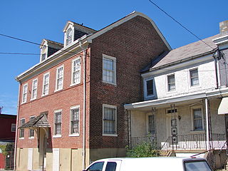
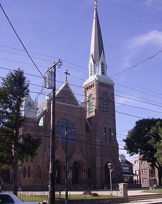
Bridesburg is the northernmost neighborhood in the River Wards section of Philadelphia, Pennsylvania, United States. A mostly working-class neighborhood, Bridgesburg is an historically German and Irish community, with a significant community of Polish immigrants who arrived mostly in the early- to mid-twentieth century. The community is home to two Catholic churches: All Saints Church, designed by Edwin Forrest Durang and built in 1889; and Saint John Cantius Church, built in 1898 in Polish cathedral style.

Tacony is a historic neighborhood in Northeast Philadelphia, United States, approximately 8 miles (13 km) from downtown Philadelphia. It is bounded by the east side of Frankford Avenue on the northwest, the south side of Cottman Avenue on the northeast, the north side of Robbins Street on the southwest, and the Delaware River and Interstate 95 on the southeast.

Juniata is a working class, predominantly Hispanic and Caucasian neighborhood in North Philadelphia, which is a section of the city of Philadelphia, Pennsylvania, United States. Juniata is located south of the Juniata Golf Club in Tacony Creek Park. It is bordered to the east by Frankford, to the west by Feltonville, and to the south by Harrowgate and Port Richmond. The neighborhood is bordered by G Street to the west, Juniata Park to the north, Tacony Creek to the east, and by SEPTA rail tracks to the south. Juniata shares the ZIP code of 19124 with the nearby neighborhood of Frankford.
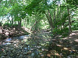
Wingohocking Creek was once a major tributary of another Philadelphia, Pennsylvania stream, Frankford Creek, which flows into the Delaware River. Frankford Creek was formed by the confluence of Wingohocking Creek and Tacony Creek. Since Wingohocking Creek is now obliterated, having been piped underground in the late 19th century, it can be confusing to look at a modern map, which shows Tacony Creek suddenly changing names "in the middle of the stream," so to speak, and becoming Frankford Creek. The point at which the name changes is near the present intersection of I and Ramona Streets, where the Wingohocking once joined the Tacony to form the Frankford Creek. What was once a major stream and the site of many mills and factories has been completely wiped off the map—all but the city's sewer maps, that is. The outlet of the Wingohocking Sewer is the largest in the Philadelphia sewer system, about 24 feet (7.3 m) high. It is visible from various points in the Juniata neighborhood and the adjoining golf course.
Northern Liberties Township was a township that was located in Philadelphia County, Pennsylvania. The township was later incorporated into the City of Philadelphia after the passage of the Act of Consolidation, 1854.

Oxford Township was a township in Philadelphia County, Pennsylvania, United States. The township ceased to exist and was incorporated into the City of Philadelphia following the passage of the Act of Consolidation, 1854.

Oxford Circle is a neighborhood in the lower Northeast section of Philadelphia, Pennsylvania, United States. Its namesake is the much used traffic circle at Roosevelt Boulevard and Oxford Avenue. The Oxford Circle neighborhood has traditionally included the areas up to Rhawnhurst and Mayfair but does not really have a fixed boundary, other than in publications about Philadelphia which are of a public relations or informational nature.

Interstate 95 (I-95) is a major north–south Interstate Highway that runs along the East Coast of the United States from Miami, Florida, north to the Canada–United States border at Houlton, Maine. In the state of Pennsylvania, it runs 51.00 miles (82.08 km) from the Delaware state line near Marcus Hook in Delaware County in the southeastern part of the state northeast to the Delaware River–Turnpike Toll Bridge at the New Jersey state line near Bristol in Bucks County, closely paralleling the New Jersey state line for its entire length through Pennsylvania.
Wissinoming is a neighborhood in the Near Northeast section of Philadelphia, United States. It was the site of locomotive builder Matthias Baldwin's estate "Wissinoming", which was located near Tacony and Van Kirk Streets. The current Wissinoming is bordered by Mayfair on the west and Tacony on the north, Bridesburg on the south, I-95 and the Delaware River on the east, and Frankford on the southwest. Wissinoming has two ZIP codes: 19124 and 19135. Physical boundaries are: Levick Street on the north, Bridge Street on the south, I-95 and the Delaware River on the east, and Frankford Avenue on the west.

Pennsylvania Route 73 (PA 73) is a 62.32-mile (100.29 km) long east–west state highway in southeastern Pennsylvania. It runs from PA 61 near Leesport southeast to the New Jersey state line on the Tacony–Palmyra Bridge over the Delaware River in Philadelphia, where the road continues south as New Jersey Route 73. The route passes through rural areas of Berks County, crossing U.S. Route 222 (US 222) in Maiden Creek before heading southeast through Oley and Boyertown. PA 73 continues into Montgomery County and intersects PA 100 in Gilbertsville and PA 29 in Schwenksville before it heads into the northwest suburbs of Philadelphia. The route passes through Skippack and intersects US 202 in Center Square, PA 309 in Springfield Township, and PA 611 near Jenkintown. PA 73 continues through Northeast Philadelphia on Cottman Avenue, crossing US 1 and US 13 before coming to an interchange with Interstate 95 (I-95) near the Tacony–Palmyra Bridge.

U.S. Route 13 (US 13) is a United States Numbered Highway running from Fayetteville, North Carolina, north to Morrisville, Pennsylvania. The route runs for 49.359 miles (79.436 km) through the Delaware Valley metropolitan area in the U.S. state of Pennsylvania. The route enters the state from Delaware in Marcus Hook, Delaware County. It continues northeast through Delaware County, passing through the city of Chester before heading through suburban areas along Chester Pike to Darby. US 13 enters the city of Philadelphia on Baltimore Avenue and runs through West Philadelphia to University City, where it turns north along several city streets before heading east across the Schuylkill River along Girard Avenue. The route turns north and heads to North Philadelphia, where it runs northeast along Hunting Park Avenue. US 13 becomes concurrent with US 1 on Roosevelt Boulevard, continuing into Northeast Philadelphia. US 13 splits southeast on a one-way pair of streets before heading northeast out of the city on Frankford Avenue. The route continues into Bucks County as Bristol Pike, heading northeast to Bristol, where it becomes a divided highway. US 13 becomes a freeway in Tullytown and continues north to its terminus at US 1 in Falls Township, near Morrisville. US 13 roughly parallels Interstate 95 (I-95) through its course in Pennsylvania.
Cheltenham Avenue is a major east-west road in Philadelphia and its suburbs. It is served by SEPTA bus routes, trolleys, regional rail, and subway. Cheltenham Avenue is an unsigned quadrant route in Montgomery County. It serves as the border between Springfield and Cheltenham townships. A section of the road along the Philadelphia border with Cheltenham Township is part of PA Route 309.
Rowlandville was a North Philadelphia neighborhood along the Tacony Creek near present-day Wyoming Avenue. Most of the former neighborhood has been absorbed into present-day Juniata Park and Feltonville.


.jpg)