
Montgomery County, colloquially referred to as Montco, is a county in the Commonwealth of Pennsylvania. It is the third-most populous county in Pennsylvania and the 73rd-most populous county in the United States. As of the 2020 census, the population of the county was 856,553, representing a 7.1% increase from the 799,884 residents counted in the 2010 census. Montgomery County is located adjacent to and northwest of Philadelphia. The county seat and largest city is Norristown. Montgomery County is geographically diverse, ranging from farms and open land in the extreme north of the county to densely populated suburban neighborhoods in the southern and central portions of the county.

Abington Township is a township in Montgomery County, Pennsylvania, United States. It is adjacent to Philadelphia's northern fringe. The population was 58,502 as of the 2020 census, making it the second most populous township in Montgomery County after Lower Merion Township. The population density is 3603.3 per square mile (1,377/km2), making it the second most densely populated township in Montgomery County after Cheltenham Township.
Lower Moreland Township is a township in Montgomery County, Pennsylvania, United States. The population was 13,917 at the 2020 census.

Upper Moreland Township is a township in Montgomery County, Pennsylvania. The population was 24,015 at the 2010 census. Upper Moreland Township is primarily a residential community with distinctive neighborhoods that are complemented by several thriving business, industrial, and commercial districts.

Willow Grove is a census-designated place (CDP) in Montgomery County, Pennsylvania, United States. A community in Philadelphia's northern suburbs, the population was 13,730 at the 2020 census. It is located in Upper Dublin Township, Abington Township and Upper Moreland Township. Willow Grove was once known for Willow Grove Park, an amusement park that was open from 1896 to 1976, now the site of Willow Grove Park Mall. Willow Grove is considered an edge city of Philadelphia, with large amounts of retail and office space.
Dublin Township is the name of some places in the U.S. state of Pennsylvania:

Somerton is a neighborhood in the Far Northeast section of Philadelphia, Pennsylvania, United States. The neighborhood is bounded by Red Lion Road on the south, Roosevelt Boulevard on the east, East County Line Road and Poquessing Creek on the north, and the Philadelphia County / Montgomery County line on the west. Somerton is adjacent to the Philadelphia neighborhoods of Bustleton, Normandy, and Byberry, the townships of Bensalem and Lower Southampton in Bucks County, and Lower Moreland Township in Montgomery County. The area is home to a large and fast-growing foreign-born population, most notably of Russian, Ukrainian, Indian, and Central Asian immigrants.
Moreland Township, is a defunct township that was located in Philadelphia County, Pennsylvania, United States.
Lower Dublin Township, also known as Dublin Township, is a defunct township that was located in Philadelphia County, Pennsylvania, United States. The township ceased to exist and was incorporated into the City of Philadelphia following the passage of the Act of Consolidation, 1854.
Upper Moreland School District is located in Upper Moreland Township, Montgomery County in the northern suburbs of Philadelphia, Pennsylvania. The Township has a general population of 25,000 residents who are served by the post offices of Willow Grove, Hatboro, and Huntingdon Valley, although due to postal and municipal boundaries, many students served by the Hatboro post office attend Hatboro-Horsham School District, while others served by the Huntingdon Valley post office attend Lower Moreland schools.
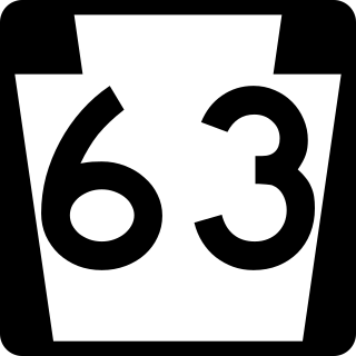
Pennsylvania Route 63 (PA 63) is a 37.4-mile-long (60.2 km) state highway located in the Philadelphia, Pennsylvania, area. The western terminus of the route is at PA 29 in Green Lane, Montgomery County. The eastern terminus is at Interstate 95 (I-95) in Bensalem Township, Bucks County. PA 63 runs northwest to southeast for most of its length. The route heads through a mix of suburban and rural areas of northern Montgomery County as a two-lane road, passing through Harleysville, before coming to an interchange with I-476 in Kulpsville. From this point, PA 63 continues through predominantly suburban areas of eastern Montgomery County as a two- to four-lane road, passing through Lansdale, Maple Glen, Willow Grove, and Huntingdon Valley. Upon entering Northeast Philadelphia, the route follows Red Lion Road and U.S. Route 1 (US 1) before heading southeast on a freeway called Woodhaven Road to I-95.

Pennsylvania Route 232 (PA 232) is a 25.2-mile-long (40.6 km) state highway located in southeastern Pennsylvania. The southern terminus of the route is at U.S. Route 1 (US 1)/US 13 at the Oxford Circle in Philadelphia. The northern terminus is at PA 32 in the borough of New Hope, Bucks County, on the banks of the Delaware River. The route passes through the urban areas of Northeast Philadelphia as Oxford Avenue, serving the Lawncrest, Burholme, and Fox Chase neighborhoods. Upon entering Montgomery County, PA 232 becomes Huntingdon Pike and through suburban areas, serving the communities of Rockledge, Huntingdon Valley, and Bryn Athyn. The route passes through more suburban development in Bucks County as Second Street Pike, running through Southampton and Richboro. In Wrightstown Township, PA 232 enters rural areas and becomes Windy Bush Road as it heads north to New Hope.

Huntingdon Valley is a village, as well as a suburban mailing address located in Lower Moreland Township, Upper Moreland Township and Abington Township all in Montgomery County, and in small sections of Upper Southampton Township and Lower Southampton Township in Bucks County, Pennsylvania, United States, bordering the Fox Chase section of Philadelphia County.
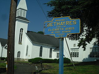
Moreland Township, is a defunct township that was located in Montgomery County, Pennsylvania. It was founded in 1682 and named by William Penn after Nicholas More, a London physician. In 1916 Bryn Athyn, Pennsylvania, in the middle of the township, separated for religious reasons. The following year, the remainder of the township separated into Lower Moreland Township and Upper Moreland Township.
Fitzwatertown is an unincorporated community located in Montgomery County, Pennsylvania, in the United States. The community is in Upper Dublin Township, 2.13 miles (3.43 km) south of Jarrettown, 2.5 miles (4.0 km) west of Abington, 1 mile (1.6 km) northeast of Oreland and approximately 12.3 miles (19.8 km) north of Philadelphia.

The 152nd Pennsylvania House of Representatives District is located in Montgomery County and Philadelphia and includes the following areas:
Moreland Township may refer to the following townships in the United States:

Fulmor is a derelict railroad station in Upper Moreland Township, Pennsylvania, located near the intersection of Warminster Road and Mill Road. The station was originally built by the North East Pennsylvania Railroad. It was later taken over by SEPTA Regional Rail for the R2 Warminster Line, and the original building was replaced by a fiberglass shelter. SEPTA closed the station in 1996 as part of several service cuts; at the time it saw only 15 riders per day.

Fulmor is an unincorporated community in Upper Moreland Township in Montgomery County, Pennsylvania, United States. Fulmor is located at the intersection of Byberry Road and Warminster Road east of Hatboro. Fulmor uses the Hatboro ZIP code of 19040. The Fulmor Heights residential neighborhood is 59.74 acres and is governed by a housing cooperative known as the Fulmor Heights Home Ownership Association. The neighborhood contains a deli, beauty salon, social club, and gathering hall.