Related Research Articles

Montgomery County, colloquially referred to as Montco, is a county in the Commonwealth of Pennsylvania. As of the 2020 census, the population of the county was 856,553, making it the third-most populous county in Pennsylvania after Philadelphia and Allegheny counties.

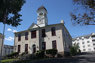
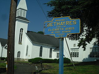
Bryn Athyn is a home rule municipality in Montgomery County, Pennsylvania. It was formerly a borough, and its official name remains "Borough of Bryn Athyn". The population was 1,375 at the 2010 census. It was formed for religious reasons from Moreland Township on February 8, 1916. Bryn Athyn is surrounded by Lower Moreland Township.
Hatboro is a borough in Montgomery County, Pennsylvania, United States. The population was 8,238 at the 2020 census.
Lower Moreland Township is a township in Montgomery County, Pennsylvania, United States. The population was 13,917 at the 2020 census.

Upper Moreland Township is a township in Montgomery County, Pennsylvania. The population was 24,015 at the 2010 census. Upper Moreland Township is a primarily residential community located about 13 miles outside Center City Philadelphia. It is made up of distinctive neighborhoods that are complemented by several thriving business, industrial, and commercial districts.

The Cradle of Liberty Council (#525) is a Boy Scouts of America council created in 1996 with the merger of the former Philadelphia Council and the former Valley Forge Council.

Pennypack Creek is a 22.6-mile-long (36.4 km) creek in southeastern Pennsylvania in the United States. It runs southeast through lower Bucks County, eastern Montgomery County and the northeast section of Philadelphia, before emptying into the Delaware River.

Pennsylvania Route 232 (PA 232) is a 25.2-mile-long (40.6 km) state highway located in southeastern Pennsylvania. The southern terminus of the route is at U.S. Route 1 (US 1)/US 13 at the Oxford Circle in Philadelphia. The northern terminus is at PA 32 in the borough of New Hope, Bucks County, on the banks of the Delaware River. The route passes through the urban areas of Northeast Philadelphia as Oxford Avenue, serving the Lawncrest, Burholme, and Fox Chase neighborhoods. Upon entering Montgomery County, PA 232 becomes Huntingdon Pike and through suburban areas, serving the communities of Rockledge, Huntingdon Valley, and Bryn Athyn. The route passes through more suburban development in Bucks County as Second Street Pike, running through Southampton and Richboro. In Wrightstown Township, PA 232 enters rural areas and becomes Windy Bush Road as it heads north to New Hope.
Bryn Athyn College is a private Christian college in Bryn Athyn, Pennsylvania. It is affiliated with the General Church of the New Jerusalem.

Huntingdon Valley is a village, as well as a suburban mailing address located in Lower Moreland Township, Upper Moreland Township and Abington Township all in Montgomery County, and in small sections of Upper Southampton Township and Lower Southampton Township in Bucks County, Pennsylvania, United States, bordering the Fox Chase, Bustleton, and Somerton sections of Philadelphia.
Pennsylvania State Senate District 12 includes part of Montgomery County. It is currently represented by Democrat Maria Collett.

The Boyertown Area School District is a large public school district which covers portions of Berks and Montgomery Counties in southeastern Pennsylvania. When the Boyertown Area School District was formed in 1953 it was one of the largest in the state, encompassing 100 square miles (260 km2). In Berks County it covers the Boroughs of Bally, Bechtelsville and Boyertown and Colebrookdale Township, Douglass Township, Earl Township and Washington Township. In Montgomery County it covers Douglass Township, New Hanover Township and Upper Frederick Township.

The 152nd Pennsylvania House of Representatives District is located in Montgomery County and Philadelphia and includes the following areas:

The Bryn Athyn School District is a public school district in Montgomery County. While it is designed to serve residents of the small Philadelphia suburb of Bryn Athyn, it has never contained a school. 90% of students in the affluent and highly religious community attend private schools operated by the General Church of the New Jerusalem, which has its global headquarters in the borough. The remaining students attend Lower Moreland Township School District. The Bryn Athyn School District is one of just four in the state to not operate a high school; Midland Borough School District in Beaver County and Saint Clair Area School District in Schuylkill County have avoided consolidation by continuing primary education only, while Duquesne City School District, which features the lowest test scores in the state, in Allegheny County had its high school closed by state mandate.
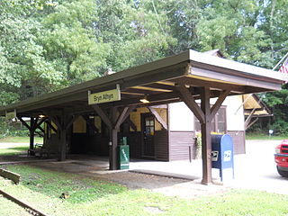
Fetter's Mill Village Historic District is a national historic district located in Bryn Athyn and Lower Moreland Township, Montgomery County, Pennsylvania. It encompasses five contributing buildings and three contributing structures. They are a wagon shed / John Conner studio (1751), Alnwick Grove Train Station, Bryn Athyn Train Station / Post Office (1902), farmhouse, stone barn, two iron bridges, and a milk platform. Located in the district is the separately listed Fetter's Mill, built about 1740.

Bryn Athyn-Lower Moreland Bridge is a historic stone arch bridge located between Bryn Athyn and Lower Moreland Township, Montgomery County, Pennsylvania. The bridge was built in 1828 and in 1858. It has two 12-foot-long (3.7 m), semi-circular spans with an overall length of 75-foot (23 m). The bridge crosses a branch of Pennypack Creek.

Fetter's Mill, also known as Louis Ewald Studio—Residence, is a historic grist mill located on Pennypack Creek at Bryn Athyn in Lower Moreland Township, Montgomery County, Pennsylvania. It was built in the 1740s, and is a five level, stucco over stone building of post and beam construction. It has an end gabled roof. It was enlarged about 1860, and in 1920 was converted to a residence and studio for decorative artist Louis Ewald. Adjacent to the mill is the contributing tail race.
Biddle Air National Guard Base is owned by the Pennsylvania Air National Guard and located in Horsham Township, Montgomery County, Pennsylvania, United States. The Air National Guard plays host to many different Army National Guard Units as well as other government agencies. The site was formerly the Naval Air Station Joint Reserve Base Willow Grove. It was renamed in honor of Charles Biddle, the founder of the Pennsylvania Air National Guard's 103rd Observation Squadron.

The Power Line Trail is a multi-use trail located in Horsham Township, Montgomery County, Pennsylvania. It follows a PECO Energy right-of-way through the township.

The Pennypack Trail is a rail trail located in eastern Montgomery County, Pennsylvania in the United States. The trail runs 6.2 miles (10.0 km) from Rockledge north to the County Line Road border with Bucks County in Huntingdon Valley along the former alignment of SEPTA's Fox Chase-Newtown Line. The trail is maintained by the Montgomery County Division of Parks, Trails, & Historic Sites.
References
- 1 2 "commerce: Fact Sheets--LOWER MORELAND TOWNSHIP". Montgomery County, Pennsylvania. December 19, 2006. Retrieved September 27, 2007.
- ↑ "commerce: Fact Sheets--BRYN ATHYN BOROUGH". Montgomery County, Pennsylvania. December 20, 2006. Archived from the original on July 23, 2008. Retrieved September 27, 2007.
40°09′08″N75°07′03″W / 40.1523°N 75.1176°W
| | This Montgomery County, Pennsylvania state location article is a stub. You can help Wikipedia by expanding it. |