Related Research Articles

Montgomery County, colloquially referred to as Montco, is a county in the Commonwealth of Pennsylvania. As of the 2020 census, the population of the county was 856,553, making it the third-most populous county in Pennsylvania after Philadelphia and Allegheny counties.

Hereford Township is a township in Berks County, Pennsylvania, United States. It is the easternmost municipality within Berks County. Its population was 2,969 at the 2020 census. It is in Upper Perkiomen School District.
Audubon is a census-designated place (CDP) in Lower Providence Township, Montgomery County, Pennsylvania, United States. It was named for naturalist John James Audubon, who lived there as a young man. The population was 8,433 at the 2010 census.
Collegeville is a borough in Montgomery County, Pennsylvania, a suburb outside of Philadelphia on Perkiomen Creek. Collegeville was incorporated in 1896. It is the location of Ursinus College, which opened in 1869. The population was 5,089 at the 2010 census.

Lower Providence Township is a township in Montgomery County, Pennsylvania, United States. The township is located approximately 17 miles northwest of Philadelphia. The population was 25,625 at the 2020 census.

Perkiomen Township is a township in Montgomery County, Pennsylvania, United States. As of the 2010 census, the township population was 9,139, which represents a 28.8% increase from the 2000 total of 7,093 residents. Governmentally, it is a township of the second class, governed by a board of supervisors. It is part of the Perkiomen Valley School District. Perkiomen Township includes an abundance of history that goes as far back as to the first tribes who inhabited the area. This township started with the inhabitants of the Lenni-Lenape Tribe and progressed in many ways into what it is today.
Schwenksville is a borough in Montgomery County, Pennsylvania, United States. The population was 1,431 at the 2020 census. It is notable for being located near the site of the Philadelphia Folk Festival. The borough was founded in 1684, when the Lenni-Lenape Indians ceded to William Penn the land along the Perkiomen Creek; it was incorporated in 1903. The borough was named for George Schwenk, whose son, Jacob Schwenk, served in George Washington's army.

Skippack is a census-designated place (CDP) in Skippack Township, Montgomery County, Pennsylvania, United States. The population was 3,758 at the 2010 census.
Skippack Township is a township in Montgomery County, Pennsylvania, United States. The population was 14,408 in 2022 according to the Census Bureau. This represents a 5.1% increase from the 2010 Census.

Upper Providence Township is a township in Montgomery County, Pennsylvania, United States. As of the 2010 census, the township population was 21,219.

The Welsh Tract, also called the Welsh Barony, was a portion of the U.S. state of Pennsylvania settled largely by Welsh-speaking Quakers. It is located to the west of Philadelphia. The original settlers, led by John Roberts, negotiated with William Penn in 1684 to constitute the Tract as a separate county whose local government would use the Welsh language. The Barony was never formally created, but the many Welsh settlers gave their communities Welsh names that survive today. A more successful attempt at setting up a Gwladfa occurred two centuries later, in the Chubut Province of Patagonia, Argentina.
Shimerville is an unincorporated community, located on Pennsylvania Route 100 and Pennsylvania Route 29 South in Upper Milford Township in Lehigh County, Pennsylvania. The community is located outside and to the south of Macungie and to the west of Vera Cruz. It is part of the Lehigh Valley, which has a population of 861,899 and is the 68th-most populous metropolitan area in the U.S. as of the 2020 census.

The Cradle of Liberty Council (#525) is a Boy Scouts of America council created in 1996 with the merger of the former Philadelphia Council and the former Valley Forge Council.
Graterford is an unincorporated community in Perkiomen Township, Montgomery County, Pennsylvania, United States.

William Penn State Forest is a Pennsylvania State Forest in Pennsylvania Bureau of Forestry District #17. The main offices are located in Elverson in Chester County, Pennsylvania in the United States.
Moreland Township was a township that was located in Philadelphia County, Pennsylvania, United States.
Oaks is an unincorporated community located in Upper Providence Township, Montgomery County, Pennsylvania, United States. The community is 18 miles (30 km) northwest of Philadelphia and its boundaries are defined in large part by the village's position at the junction of Perkiomen Creek and the Schuylkill River.
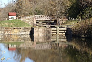
Mont Clare is a village in Upper Providence Township, Montgomery County, Pennsylvania. The village is located on the left bank of the Schuylkill River opposite Phoenixville and Chester County. Mont Clare is at the site of the former Jacobs' ford. Mont Clare hosts the only functional lock and one of only two remaining watered stretches of the Schuylkill Canal. Mont Clare was the birthplace of the infamous outlaw Sundance Kid.
Providence Township was a township in southeastern Pennsylvania, United States from 1729 until it was divided in 1805. Initially the township was part of Philadelphia County. Then in 1784, Providence Township was in that portion of Philadelphia County that was split off to form Montgomery County.
Germantown Pike is a historic road in Pennsylvania that opened in 1687, running from Philadelphia northwest to Collegeville. The road is particularly notable for the "imposing mansions" that existed in the Germantown neighborhood in Philadelphia. The road was left in ruins after the British destroyed it in the Revolutionary War during the 1777 Battle of Germantown, and was not rebuilt until 1809. Portions of Germantown Pike were signed as U.S. Route 422 (US 422) before the latter was rerouted along a freeway alignment to King of Prussia.
References
- ↑ Corcoran, Irma (1992). Thomas Holme, 1624-1695: Surveyor General of Pennsylvania. Philadelphia: American Philosophical Society. p. 166. ISBN 0-87169-200-7 . Retrieved 9 January 2012.
- ↑ Marriage recorded 5 Nov 1600 in St. Mary Redcliffe church, Bristol, England, St Mary Redccliffe Archives
- ↑ Reed, W. H. (1910). Historical sketches: A collection of papers. Vol. 4. Historical Society of Montgomery County. p. 174. Retrieved 10 January 2012.
- ↑ Corcoran, p. 282.
- 1 2 "How Penn Divided His Vast Holdings of Land". Reading Eagle . 21 July 1932. p. 6. Retrieved 9 January 2012.
- ↑ Reed, p. 175.
40°07′05″N75°27′22″W / 40.118°N 75.456°W
| | This Pennsylvania-related article is a stub. You can help Wikipedia by expanding it. |